Part of a series of articles titled Yellowstone Science - Volume 26 Issue 1: Archeology in Yellowstone.
Article
A Look Back, Historic Relief Model Helped the Public Understand the Human Relationship to Yellowstone Geology
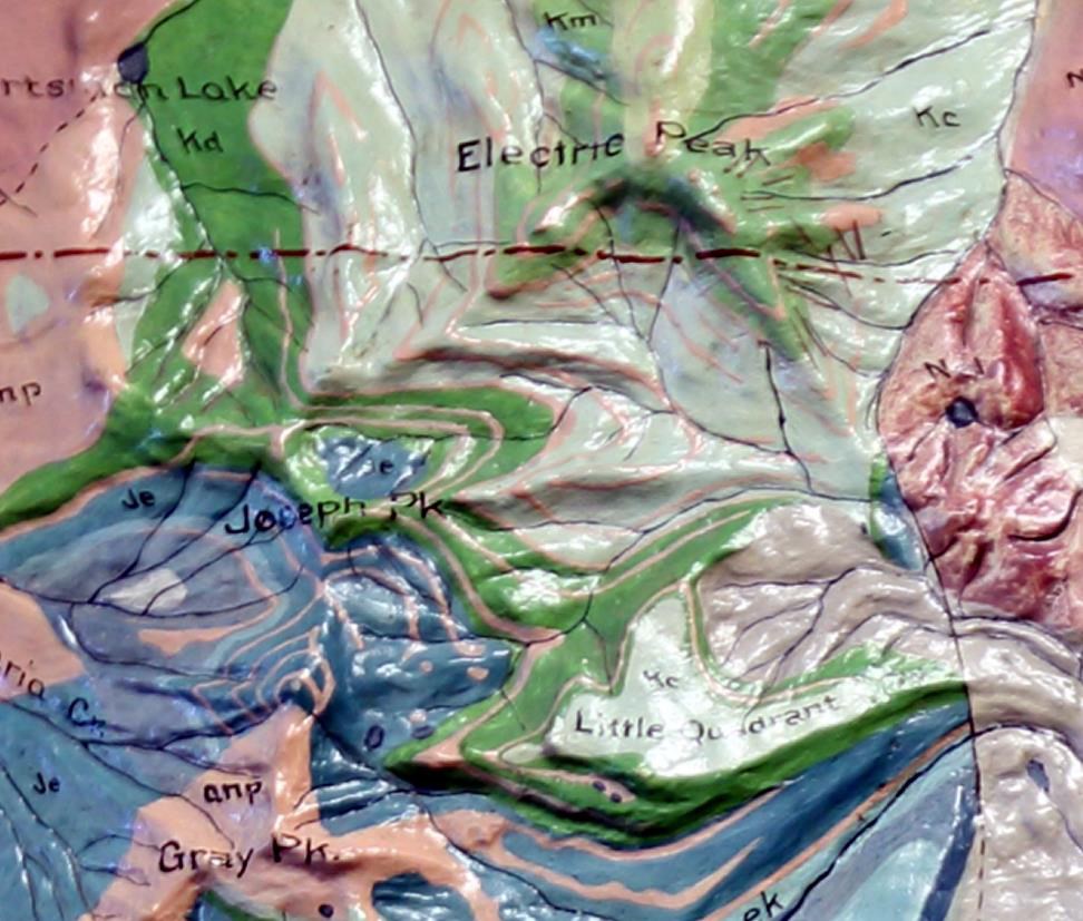
Photo - M. McCalmont
Historic Relief Model Helped the Public Understand the Human Relationship to Yellowstone Geology
by Melanie Schleeter McCalmont
In the Yellowstone Justice Center in Mammoth, Wyoming, is a historic 1897 geologic relief model of Yellowstone National Park and the Absaroka Range by Edwin E. Howell. At 7 ft. square, it’s a stunning scientific sculpture of a beloved geologic region in the U.S. (figure 1). It was donated to the park in 1921 and was installed in the old Information Center in Mammoth. A second relief model crafted by the Western Museum Laboratory in the 1930s is a cast copy of the Howell model and is installed at the Mammoth Community Center.
This article tells the relief model’s cultural anthropology—how it arrived, why it was built, and its historic role in the scientific study of Yellowstone National Park (YNP). While the actual data on the maps have been superseded by modern satellite and ground imagery, these historic maps and their educational interactions with park visitors persist to this day.
What’s a Relief Model?
A relief model is a three-dimensional terrain map. From the 1870s to 1950s, relief models were a popular interpretive object for museums, schools, and offices to display a landscape and its science.
Standing in front of it at the old Information Center in 1921, tourists of any educational level had an immediate grasp of the entire park. They could understand the relationship of geologic to cultural features—geysers, mountains, and fossil forests crossed by a network of rails, trails, and hotels—and so could better understand their human relationship to the science under their feet. Howell was a master at combining art and science in relief models for the public understanding.
Description of the Relief Model
The YNP relief model is about 7 ft. square and represents about 6,800 square miles, or about 4.3 million acres (figure 2). The 1897 model is colored geologically, based on the Arnold Hague U.S. Geological Survey (USGS) survey of the 1880-1890s (Hague 1899). Around the edge is a flat apron with the label “5000 Ft. Above Sea Level.” This apron was a standard method for relief models to show the base elevation and allow a more realistic vertical scale.
On either side of the title block are two geologic legends: on the left are geologic color patches of the major sedimentary formations and on the right, color patches for the major igneous flows. Within each legend, the formation patches are arranged from most recent to oldest formations reading left to right. On the model’s map surface, the legend colors are labeled with the text key (e.g., Cm for Carboniferous Madison formation). A small symbol “FAULTS ----- - - -” in the right igneous legend indicates the many fault lines on the map.
Although not in the legend, the park’s cultural geography of the time is shown as a reference. Solid red lines indicate improved stage and carriage roads of the time, and red dashed horse and foot trails branch off from the main roads to popular sights. Park hotels are small black squares with labels. The Continental Divide is shown as a long-dash red line running from the Madison Plateau southeast to Twin Ocean Pass. The boundary line shown on the relief model is the pre-1929 boundary.
At first glance, some railroad track symbols appear to be on the YNP relief model, for example, along the north shore of Yellowstone Lake (figure 3). But railroads were not in the park in 1897 when the original map was created. The ‘track’ symbols are actually later road corrections made on the map. You can see corrections between Bunsen Peak and Mt. Everts, the old road line (red) has been crossed out and moved from the north to the south side of the valley. The road between Junction Butte and Crescent Hill, now the Northeast Entrance Road, has been redrawn. Roads have been altered on the Solfatara Plateau, near Kepler Cascade, and along the northwest shore of Yellowstone Lake. Not just roads, but physical features were corrected. What was previously labeled as the Stinkingwater River has been crossed out (figure 4) and changed to Shoshone River by park artisans due to the Wyoming legislature’s name change (State of Wyoming 1901).
Edwin Howell was skilled at using color themes to help the viewer intuitively grasp the geologic story. Starting with a deep red color, the map lightens this red shade of each younger igneous flow until it becomes white at the most recent eruptions. Deep and light orange likewise display the age of these unusual intrusive formations in the Absarokas. For sedimentary rock, Howell uses greens and blues, again making them lighter in color as they get younger. For a tourist public, Howell’s deliberate and consistent color themes helped them visualize their own human lifespan in relation to geologic time. The stacked colors were a layer cake of volcanic lava, ocean-bottom sediment, violent fissures, and trickling erosion that created Yellowstone’s features. Yellowstone was not just their vacation spot; they were participating in earth’s history.
Like many of Edwin Howell models, the geologic coloring continues below the “surface” of the land. When you visit the relief model at the Yellowstone Justice Center, look at the edges. The geologic strata continues along the sides so the viewer could imagine how the surface geologic features warped or faulted below the surface and possibly emerged at another point at the surface.
Today, with the YNP relief model over 120-years-old, it has sustained some damage. The model was first installed in the park’s new Mammoth Information Center in 1921, then moved to the Norris Museum, and likely moved many more times before its present location. A long horizontal gouge runs across the model just below the park border, exposing the core plaster. Because this model type had its frame recessed from the terrain, many of the higher mountain tops are sheared off the lower half of the model. The corners are cracked, a few carved initials can be discovered, and a puncture is on Coulter Creek. Even so, the relief model is in good enough shape that visitors and researchers could use it today as a comparison against newer maps.
Finally, some mistakes and corrections can be found on the YNP relief model. “The Thunderer” is labeled “The Thundere” missing the last ‘r’ named after the famous John Philips Sousa march that was popular during the pre-park surveys.
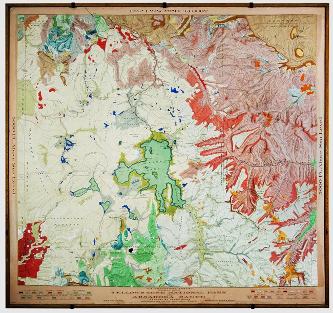
Photo - ©M. McCalmont.
The Scientific Origins of This Relief Model
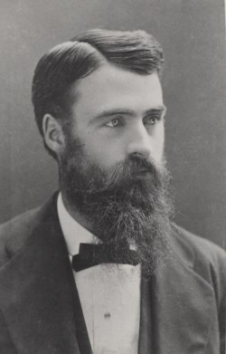
The model at Yellowstone today was crafted by Edwin E. Howell (1845-1911, figure 5), a premier relief model maker in the U.S. with a knack for making beautiful scientific maps. Howell crafted models for scientific luminaries of the time, such as geologists Grove Karl Gilbert, John Wesley Powell, and Clarence King, and had personally worked in the Wheeler and Powell surveys of the West. He was a friend and colleague of Arnold Hague, F.V. Hayden, and Charles Wolcott, all with a keen interest in Yellowstone (Biel 2004, McCalmont 2015, Russell 1934).
Howell was asked by USGS Director John Wesley Powell to draw up a relief model of YNP for the August 1891 International Congress of Geologists (IGC). Members of the IGC traveled to Yellowstone with Powell as a post-congress field trip (Howell 1891). Powell used it as an illustration on USGS work in the field. The model was a simple light brown topographic version with the major water and cultural features labeled. This early version resides in the Library of Congress Map Division.
From the 1891 IGC publicity, Edwin E. Howell received a new order from U.S. Government Board of Control to construct an updated relief model of the YNP for exhibition at the upcoming 1898 Trans-Mississippi and International Exposition in Omaha, Nebraska. The board wanted to illustrate the boundaries of the new 1891 national forest reserves and to feature the ongoing USGS survey data of the Yellowstone area by Arnold Hague (Science 1897). This model is the version the park has today.
On August 28, 1897, Howell walked over from his shop on 17th and F Street in Washington, D.C., to the U.S. Geological Survey offices to discuss the new Yellowstone model (Howell 1897). He met with Arnold Hague, the Geologist-in-charge of the ongoing USGS Survey of the YNP and vicinity. Hague’s published work on Yellowstone would become USGS Monograph 32 and USGS Geologic Atlas GF-30 (Hague 1896). After a review of the Hague’s data thus far, Hague promised Howell some improved draft geologic map sheets by October for the updated model.
Howell redesigned the Yellowstone relief model in two larger halves (the faint joint can be seen today if one looks from left to right from the words “Above” to “Sea”). To build up a relief model, Howell would enlarge USGS topographic sheets and dissect its contours for pasting onto special cardboard. The cardboard contours were stacked, glued, and nailed together with control markings every 500 ft. A layer of special clay was applied and carved into the correct terrain by his longtime geographic modeler, Miss Dawson. A mould was crafted; then the positive plaster model was cast, sanded, and sealed. The geologic markings from Hague’s data were precisely applied to the surface with artists’ paint, using all available photographs, field notes, stereographic sections, and historic maps. The title block lettering was applied by the woman artist who lettered all the signage at the National Museum. For the model’s final critique on April 9, 1897, Arnold Hague and his field assistants from the 1883 Yellowstone survey, Joseph Iddings and Walter Weed, spent the day at Howell’s model shop to validate the geologic model and terrain. Updates were made to the geology. For Howell, this in-person critique was a required quality control step. Geologic relief models were scientific illustrations.
In May, the nearly-complete model’s last visitor was USGS Director Charles Walcott, a longtime friend of Howell, who approved the model and then stayed for lunch to discuss the problem of how much scientific work was still undone at Yellowstone (Howell 1897, Smith 2006). Wolcott later ordered a copy of this YNP relief model for its Geology Room at the U.S. National Museum (now the Smithsonian Museum), where it was displayed for decades next to fossils, rocks, and specimens from the park (US National Museum, 1918).
On May 13, 1897, the YNP geologic relief model was shipped to the Omaha Trans-Mississippi and International Exposition by train and installed in the government building. At the exposition, the director of the South Kensington Museum, now the Science Museum of London, was so impressed by the Yellowstone model that he purchased the display model on the spot and had it shipped to London when the fair closed.
In January 1899, Arnold Hague wrote to Edwin Howell that he had been invited to give a March 8 capstone speech on his Yellowstone geologic research at the 89th meeting of the Geological Society of Washington. Hague’s USGS Monograph 32 and Geologic Atlas GF-30 would be published, or nearly published, by then; and the geologic community was anxious to hear Hague’s report (Hague 1896, Iddings 1919). Hague ordered a copy of the model to illustrate this speech. Howell crafted it in February, making a few corrections; and on March 8, they carefully packed it and shipped it the few miles to the Cosmos Club in Washington, D.C. Edwin Howell and Miss Dawson, the modelmakers, attended Hague’s talk that evening (GSW 1899). On March 11, 1899, Howell carried it to the USGS Hooe Building and had Yellowstone National Park and the Absaroka Range map installed in Dr. Hague’s office.
The journal Science acclaimed Hague’s March 8th Yellowstone talk, setting a photograph of the model as its main illustration. They noted, “Mr. Hague stated that he hoped the map would be sent to the Paris Exposition next year,” and Howell did send it as an example of American scientific strength. In July 1901, Howell fulfilled an order from the University of Wyoming for a copy of the 1897 YNP model, along with a model of Mt. Vesuvius. After Howell’s death in 1911, former Howell employees, the Robertson brothers of Washington D.C., continued to sell copies of the Yellowstone relief model to universities and museums worldwide until the 1930s.
How Did This Model Come to the Park?
During the summer of 1921, the YNP and Absaroka Range geologic relief model was installed in the new Information Office for Yellowstone (USNPS 1921). It was a gift to the park by longtime national park champions, Mr. and Mrs. Alvah Davison of New York City.
The Davisons were wealthy publishers of commercial books and part of the “Brooklyn Eagle,” a travel group sponsored by the Brooklyn Daily Eagle newspaper. The Eagle group, like many of its kind nationwide, had keen interests in all the new national parks. Intrepid stewards, they had attended the dedication of Hawaiian National Park, Grand Canyon National Park, and Mount McKinley National Park as guests of National Park Service (NPS) Director Stephen Mather, longtime friends of the Davisons. But more than just tourists, the Davisons felt strongly that parks, from their inception, needed stewardship and scientific study (Brooklyn Daily Eagle 1922). The Davisons, having seen the effectiveness of Howell relief models at natural science museums in New York, contacted the modeling company and placed an order.
Horace M. Albright, superintendent of YNP, on receipt of the model, wrote Mr. Davison:
I am happy to advise you that the new relief map of Yellowstone National Park made by Robertson Brothers, Washington, D.C., has been received and placed in our big new information office. The map is entirely satisfactory in every respect and is a source of unending pleasure to the tourists who crowd about it during every hour of the day. I wish that you and Mrs. Davison might have an opportunity to see how much pleasure it is giving the Park visitors.
The Davison’s gift allowed visitors to better appreciate why viewpoints and trails had been built in those places. They could recognize volcanic cones, breccia with basketball-sized boulders embedded in other rock, entombed fossil fish and trees, and active fault zones. As for hydrogeology, visitors could trace the sources of three of the largest rivers in America within a radius of 10 miles and, of most interest, could visualize the pattern of geysers and mineral springs within the park.
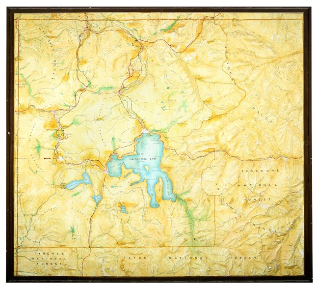
Photo - ©M. McCalmont
Is This the Only Relief Model at Yellowstone?
Today, YNP also has an interesting copy of the Howell model that is installed in the Mammoth Community Center in the park. The model has no title block, but its features and cultural sites date it the late 1930s and is a cast of the Howell relief model. The model size and topography are nearly exact, but it was painted and labeled without the geologic map coloring of the original. A large red arrow at the Lower Geyser visitor center as a “you are here” locator suggests it was installed at Lower Geyser as an area map.
Whereas the Howell model is an example of the cultural impact of Yellowstone science, this Yellowstone model is an example of federal works programs and their cultural impact on national parks (Fechner 1935, Lewis 1993, Smith 2014). Ned J. Burns wrote in the Field Manual for Museums in 1934 that:
Under the Emergency Conservation Work program supervisors and technicians were employed to guide the work of Civilian Conservation Corp, enrollees assigned to the laboratories to manufacture relief maps and other interpretative devices needed in the park museums. Civil Works Administration employees were made available as curators and research workers (Burns 1941).
Under the direction of Ansell Hall, chief naturalist of the NPS, and the landscape artist Ferdinand Burgdorff in Berkeley, California, over 100 men and women at the Western Museum Laboratory (WML) learned museum artisan skills and produced educational maps, posters, dioramas, and displays for many national parks (Bend Bulletin 1933, Berkeley Daily Gazette 1934). Despite federal defunding and post-war changes, the WML remained a source for museum exhibits for western national parks until the 1960s.
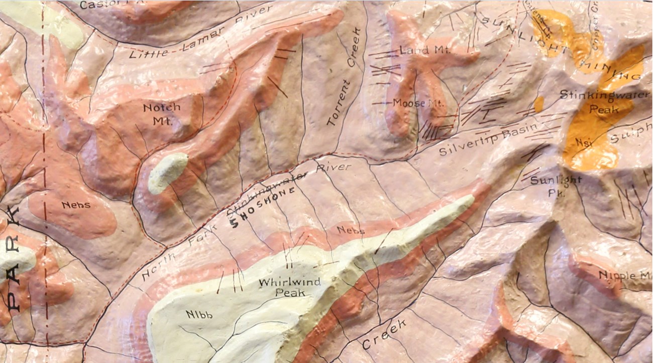
Photo - ©M. McCalmont
Literature Cited
Bend Bulletin. 1933. World’s largest map depicts west. Bend, Oregon, USA.
Berkeley Daily Gazette. January 8, 1934. Local artists aided by WPA. https://news.google.com/newspapers?id=Rzk¬yAAAAIBAJ&sjid=4-MFAAAAIBAJ&pg=932%2C608682
Biel, A.W. 2004. The bearer has permission. Yellowstone Science 12:3.
Brooklyn Daily Eagle. Janaury 22, 1922. Yellowstone map gift to park. Brooklyn, New York, USA.
Burns, N.J. 1941. Field manual for museums. United States Government Printing Office. Washington, D.C., USA.
Fechner, R. 1935. Two years of emergency conservation work. Civilian Conservation Corps. http://ir.library.oregonstate.edu/xmlui/handle/1957/16409
Geological Society of Washington Notes. 1899. Societies and academies. Science 9:221.
Hague, A.. 1899. The early tertiary volcanoes of the Absaroka range. Science 9:221.
Hague, A., J.P. Iddings, W.H. Weed, C.D. Walcott, G.H. Girty, T. W. Stanton, and F. H. Knowlton. 1899. Geology of the Yellowstone National Park; Part I. General geology (not published), Part II. Descriptive geology, petrography, and paleontology. Government Printing Office, Washington, D.C., USA.
Hague, A, W.H. Weed, J.P. Iddings. 1896. Yellowstone National Park folio, Wyoming. GF-30 Geologic Atlas of the United States. U.S. Geological Survey, Washington, D.C., USA.
Howell, E.E. 1891. Yellowstone National Park. Relief model. Library of Congress Map Division, Washington, D.C., USA.
Howell, E.E. 1897. Yellowstone National Park and the Absaroka Range. Relief model. Yellowstone Justice Center, Mammoth, Wyoming, USA.
Howell, E.E. Multiple years. Personal manuscripts. University of Rochester Special Collections, Rochester, New York, USA.
Iddings, J.P. 1919. Biographical memoir of Arnold Hague, 1840-1917. National Academy of Sciences Biographical memoirs, Volume IX. National Academy Press, Washington, D.C., USA.
Lewis, R.H. 1993. Museum curatorship in the National Park Service, 1904-1982. Department of the Interior, National Park Service, Curatorial Services Division, Washington, D.C., USA.
McCalmont, M. 2015. A wilderness of rocks: the impact of relief models on data science. Friesen Press, Vancouver, British Columbia, Canada.
Russell, C.P. 1934. Concise history of scientists and scientific investigations in Yellowstone National Park with a bibliography of the results of research and travel in the park area. U.S. Office of National Parks, Buildings, and Reservations, Washington, D.C., USA.
Scientific Notes and News. 1897. News item about E. E. Howell. Science 6(148):659–664.
Smith, D., and E. Yochelson. 2006. Charles Doolittle Wolcott: forgotten researcher. Yellowstone Science 14:4.
Smith, H. 2014. Berkeley and the New Deal. Arcadia Publishing, Charleston, South Carolina, USA.
State of Wyoming. 1901. Chapter 39: Stinking water River name change. Session laws of the State of Wyoming. Chaplin, Spafford, & Mathis, Laramie, Wyoming, USA.
U.S. National Museum. 1918. Report on the progress and condition of the United States National Museum for the year ending June 30, 1917. Government Printing Office, Washington, D.C., USA.
U.S. National Park Service. 1920. Reports of the Director of the National Park Service to the Secretary of the Interior 1919-1925. Government Printing Office, Washington, D.C., USA.
U.S. National Park Service. 1921. Report of the Director of the National Park Service to the Secretary of the Interior. Government Printing Office, Washington, D.C., USA.
Yellowstone National Park Relief Model. c.1938. Western Museum Laboratory. Mammoth Community Center, Mammoth, WY.
Last updated: April 10, 2019
