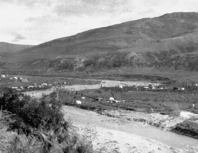
1922 U.S. Geological Survey, P.S. Smith Collection #1404
In 1903, very little was known about the Denali region when Judge James Wickersham made the first attempt to climb Mount McKinley. Although unsuccessful in reaching the summit of Mount McKinley, Wickersham played a pivotal role in the mining history of the area. He found a little gold in Chitsia Creek in the northern Kantishna Hills and staked four claims.
Alaska, having experienced both major and minor gold rushes for the previous twenty years, was primed and the news of Wickersham’s discovery spread. By 1904 numerous prospectors were picking and panning the creeks draining the Kantishna Hills. The Kantishna stampede was the result of relatively simultaneous gold discoveries by Joe Dalton on Eureka Creek and Joe Quigley on Glacier Creek. News of these discoveries in June of 1905 brought thousands of prospectors into the area. Towns such as Diamond, Glacier City, and Roosevelt were quickly established as supply points along the northern river routes used by the stampeders to reach the gold fields of the Kantishna Hills. In very short order, most of the creeks in the Kantishna Hills were staked from beginning to end (Capps 1918).
By the fall of 1905, Eureka, on Moose Creek at the mouth of Eureka Creek, became the hub of the district. Numerous stores in Eureka supplied the local miners, and a restaurant which commanded $4.50 a day for board alone was a successful enterprise (Prindle 1907). In addition to the commercial establishments, a few cabins and about 20 tents were located in Eureka (Sheldon 1930). In December 1905 a post office was established, officially changing the name of the community to Kantishna (Dickerson 1989, Orth 1967). A permanent land recording office was established in 1909, with Bill Lloyd, a local miner, serving as the first commissioner of Kantishna. In 1919-20, C. Herbert Wilson became Kantishna’s commissioner, constructing the Kantishna roadhouse as a residence for his family (Brown 1991).
Over the years, the building became a focal point of the community, serving as the post office, the commissioner’s office, and a place for travelers and others to spend the night. The historic Kantishna Roadhouse still stands on its original site. Placer gold (gold washed from creek gravels) was found in many of the creeks throughout the district, but before long all those who rushed into Kantishna realized that the only areas which were showing a profit were the placer gold claims on Eureka and Glacier Creeks, most of which were held by Dalton and Quigley. As fast as it grew, Kantishna’s population diminished during the spring of 1906. Kantishna survived the population decrease because those who remained in the area, Joe Dalton and Joe and Fannie Quigley, continued to turn a profit. They stayed for most of the rest of their lives. Glacier City also survived for several more years, owing to its location as a transportation point and lumber resources. However, the other communities soon faded from existence. During the early years of placer gold mining in Kantishna, annual gold production fluctuated between $20,000 and$30,000 from several creeks, including Moose, Eureka, Glacier, Caribou, Glen, and Friday Creeks (Brooks and Martin 1921).
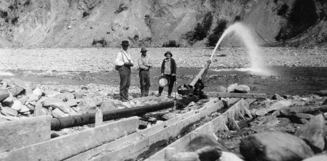
Placer miners, with pick and shovel, used the open-cut method, groundsluicing the upper gravel layer, then shoveling the lower layer, down to bedrock, into sluice boxes. Using automatic dams, the miners collected a large amount of water, which when released, enabled them to ground-sluice a large area in a short amount of time. The remoteness of the region, as well as the relatively narrow drainages of the gold bearing creeks, dictated the use of simple mining methods. Supplies and equipment had to be barged on the rivers from Fairbanks or Nenana and then hauled overland using sleds or wagons. Transportation difficulties and lack of space to operate large equipment in the narrow creek drainages prohibited the use of hydraulic and mechanized mining methods and restricted mining to shallow deposits.

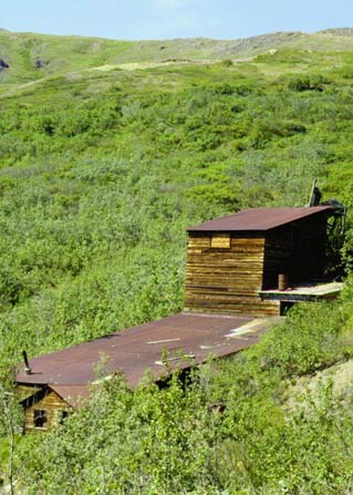
NPS Photo
Placer gold was primary to the mining activity, but was not the only mineral found in quantity. Gold lodes, mineral found in veins in bedrock, were not plentiful in the district, but other mineral lode mines were discovered as a result of the quest for gold lodes. The Quigleys were responsible for much of the exploration and development of both gold and other ore deposits, including galena and stibnite, which contain lead and antimony. Lode mining of these ores, as well as silver, zinc, and copper occurred throughout the district. Profitable quantities of antimony, used in hardening lead (mainly for munitions and as an alloy for other metals), were found on Stampede, Slate and Caribou Creeks, while lead-silver deposits were located on the ridge between Eureka and Friday Creeks.
Although Quigley was the dominant mining figure in Kantishna, several others played a significant role in the district. Miners William Taylor, Pete Anderson, Charles McGonagall, and Tom Lloyd are probably better known for the 1910 Sourdough Expedition, the first successful ascent of Mount McKinley’s north peak, than they are for mining. However, these men lived and mined in the Kantishna District for the better part of their lives.
Transportation of equipment into Kantishna and shipments of ore out of the district played a crucial role in the success or failure of mining ventures. Over and over again transportation expenses had a major impact on the district. During the first years of mining, access to the district was from the north traveling the Yukon River to the Tanana River to the Kantishna River. At the community of Roosevelt on the Kantishna River a rather crude over-land corduroy road, constructed using logs as a base with dirt over the top, extended to the southeast for approximately thirty miles to Glacier City and into the Kantishna Mining District. Naturally, the rivers were only navigable in summer at which time the road was a virtual quagmire. Consequently, equipment and ore had to be shipped over the road in the winter requiring the stockpiling of goods in the fall at Roosevelt, waiting for the road to freeze.
In 1917 Congress created Mount McKinley National Park encompassing an area to the south and east of the mining district. By the early 1920s, the Alaska Railroad (ARR) was completed from Seward to Fairbanks skirting the eastern boundary of the park. A winter sled road from Kobe to the east at the Nenana River on the railroad provided an alternate route for shipping, but did not solve the transportation problems for the district; this road, too, became a swamp during the summer months.
By the early 1920s gold production was on the decline. Even so, large scale hydraulic placer mines were beginning to operate in some areas, where drainage width allowed. Two companies set up hydraulic operations on the wider drainages of Moose, Caribou, and Glacier Creeks. The Kantishna Hydraulic Company constructed a twelve thousand foot long ditch system, including dams and piping, to bring water from Wonder Lake to Moose Creek, just above Eureka Creek. Along the banks of Moose Creek in the Eureka/Kantishna settlement five hydraulic giants were used to strip the gravel and run it through the sluice boxes (Bundtzen 1978). Although the Kantishna Hydraulic Company developed a rather extensive operation on Moose Creek, the amount of gold recovered was not nearly as much as anticipated. The mining enterprise was soon scaled back, but it did continue for a few years.
Mount McKinley Gold Placer Company, Incorporated, began setting up hydraulic operations on Caribou Creek in 1920. As with the Kantishna Hydraulic Company on Moose Creek, an extensive ditch and flume system was associated with this mining venture. In 1922 the mine was in full operation, but the high investment in equipment, wages, and transportation soon took its toll. The amount of gold recovered was not nearly enough to offset the high costs, and the operation was suspended in 1923. The Mount McKinley Gold Placer Co. also held claims on Glacier Creek but there is no evidence that any work occurred on this creek during that time period (Buzzell 1989).
In the mid-1920s the mining activity in Kantishna was in serious decline. In 1925 only thirteen miners were successfully producing gold (Bundtzen 1978). Dalton, the Quigleys, and a few others remained, despite the decline. Mining in the Kantishna area continued to decline until the mid-1930s. Two events occurred that helped bring about an increase in production of both gold and the various ores from the lode mines. In 1934 President Roosevelt raised the price of gold to $35.00 an ounce, making gold mining much more profitable. In 1938 the Alaska Road Commission (ARC) finally completed the road from the ARR at McKinley Park Station to the Kantishna Mining District, greatly diminishing the transportation problems and making Kantishna accessible year round. Mining in Kantishna began to change once again as it moved into a boom period. Several mills were constructed to process the ores from lode mines, and placer mining moved into a new phase with the introduction of new equipment. As a result, over the next few years, the Kantishna District produced more gold, both lode and placer, than at any earlier time (Buzzell 1989).

Denali Museum Collection, DENA 16-1.6
In the 1930s the Carrington Company of Fairbanks, also known as Caribou Mines, leased claims on Caribou Creek from William Taylor and began placer mining using a dry-land dredge which had a trommel screen, sand elevator, belt stackers, and recovery tables. A dragline fed the gold-bearing gravel into the dredge (Bundtzen 1978). The Carrington Mines operated three seasons on Caribou Creek, from 1939-41, and became the most productive placer-gold mining operation in the history of the Kantishna District. U.S. Geological Survey geologist Edward Cobb wrote in 1973 that the total gold production on Caribou Creek in 1940 was 4,000 ounces, most of which came from the Carrington Mines (Cobb 1973). By the late 1930s and early 1940s the mining industry in the Kantishna Hills was prospering. The Banjo Mill of the Red Top Mining Company was milling and shipping tons of gold ore, and the Carrington Company was mining a large section of Caribou Creek with the drag-line system. At a time when gold mining in the Denali region was thriving, World War II shut down the industry as a whole. Federal Order L-208 directed the closure of gold mining operations as a non-essential wartime industry. All the larger placer and lode operations in Kantishna closed, with only a few small operators continuing to work during the war years.
The end of the war brought renewed interest in mining, but at much lower levels than before the war. The Carrington mine on Caribou Creek reopened in 1946 and continued as the largest gold producing operation until 1948, when they leased the equipment to the Glacier Creek Mining Company for use on Glacier Creek. However, in 1949 both Carrington and the Glacier Creek Mining Company closed down; the gold on both creeks had been depleted.
For the first 40 years of mining (1905-45) in the Denali region, mining methods changed very little. However, after World War II, the bulldozer became a very important piece of mining equipment, not only in Kantishna, but industry-wide. Some of the small one- or two-man placer operations, Johnny Busia on Moose Creek for instance, continued using the simple pick and shovel techniques and the hydraulic equipment; but the bigger operations turned to the bulldozer-hydraulic combination, increasing efficiency and productivity.
Throughout the 1950s and 1960s and into the 1970s, placer mining continued in the heart of Kantishna, but there were no major strikes. Most of the claims were worked with heavy equipment such as bull-dozers and front end loaders.
With the passage of Alaska National Interest Lands Conservation Act (ANILCA) in 1980, Kantishna became part of Denali National Park and Preserve. There were over 400 patented and unpatented mining claims in the ANILCA additions. While not all of these claims were actively mined, there was still substantial mining activity occurring. Section 202(3) of ANILCA directed the Alaska Land Use Council, in cooperation with the Secretary of the Interior, to conduct a study to evaluate the resources of the Kantishna Hills and Dunkle Mine areas. Information compiled for this study was to include mineral potential, estimated cost of acquiring the mining properties, and the environmental impacts of mineral development. ANILCA permitted mining to continue during the study period, subject to regulation.
In 1985, the Park Service was directed to do a Environmental Impact Study of mining. The final report, issued in 1990, recommended that the NPS acquire all patented and valid unpatented mining claims in the park. This, of course, would be a long drawn-out process involving validity exams, land appraisals, and more lawsuits filed by miners. Today this process still is not complete, but the vast majority of the claims are now Park Service property.
References
Brooks, Alfred Hulse, and G. C. Martin. 1921.
The Alaska Mining Industry, The Future of Alaska Mining and the Alaskan Mining Industry in 1919. U.S. Geological Survey Bulletin 714-A. Government Printing Office. Washington, D.C.
Brown, William E. 1991.
A History of the Denali – Mount McKinley Region, Alaska. National Park Service, Southwest Regional Office. Santa Fe, NM.
Bundtzen, Thomas K. 1981.
Geology and Mineral Deposits of the Kantishna Hills, Mount McKinley Quadrangle, Alaska. MA Thesis. University of Alaska Fairbanks. Fairbanks, AK.
Bundtzen, Thomas K. 1978.
A History of Mining in the Kantishna Hills. The Alaska Journal (Spring 1978).
Buzzell, Rolfe. 1989.
Overview of Mining in the Kantishna District. Unpublished manuscript. National Park Service. Anchorage, AK:
Capps, Stephen R. 1918.
Mineral Resources of the Kantishna Region, Mineral Resources of Alaska: Report on Progress of Investigations in 1916. US. Geological Survey Bulletin 662. Government Printing Office. Washington, D.C.
Dickerson, Ora B. 1989.
120 Years of Alaska Postmasters. Carl J. Cammarata. Scotts, MI
Orth, Donald J. 1967.
Dictionary of Alaska Place Names. Geological Survey Professional Paper 567. Government Printing Office. Washington, D.C.
Prindle, L.M. 1907.
The Bonnifield and Kantishna Regions, Report on Progress of Investigations of Mineral Resources of Alaska in 1906. U.S. Geological Survey Bulletin 314. Government Printing Office. Washington, D.C.
Sheldon, Charles. 1930.
The Wilderness of Denali: Explorations of a Hunter-Naturalist in Northern Alaska. Charles Scribner’s Sons. New York.
Last updated: October 26, 2021
