Courtesy of Steve Estes, Alaska Earthquake Information Center
Denali lies in the heart of earthquake country, and visitors may be treated to a ground shaking experience. Scientists, on the other hand, view the park as a natural laboratory for studying earthquakes and tectonics.
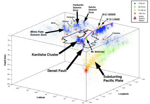
This was never more evident than in the fall of 2002, when two large earthquakes occurred. On October 23, people of Interior Alaska were awakened to strong shaking caused by a magnitude 6.7 earthquake. The epicenter was located west of Nenana Mountain on the Denali fault, 2.6 miles (4.2 km) beneath the ground surface. Though damage from this quake was limited to a small area around the epicenter, it was only the beginning of a larger sequence of events. Ten days later on November 3, a magnitude 7.9 earthquake began to the east of the Nenana Mountain earthquake and ruptured for nearly 217 miles (350 km) to the east. The fact that the Denali fault continues from the eastern boundary of the park westward into the park is one of the many reasons that the Alaska Earthquake Information Center (AEIC) maintains an active monitoring and research program in Denali.
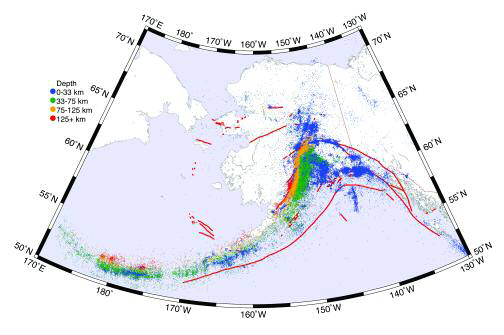
The tectonics of Alaska is dominated by the processes associated with plate tectonics. Earthquakes are caused by the movements of tectonic plates that form the earth’s crust and occur at the boundaries where the plates meet. Along the southern coast of Alaska, the Pacific plate is colliding with Alaska (the North American plate), with a convergence rate of 2-3 inches (5-7.5 cm) per year. This gives rise to the subduction zone (the sinking of the Pacific plate underneath Alaska) and the cause of the many deep earthquakes that occur throughout Alaska and the Aleutian Islands. The subducting Pacific plate makes a fairly sharp bend directly under Denali and is particularly seismically active at that location. This seismicity is often referred to as the McKinley Cluster.
Courtesy of Steve Estes, Alaska Earthquake Information Center
In addition to convergence by subduction, deformation of the continental plate due to this collision extends far into the Interior creating a system of long crustal faults. The Denali massif is bounded to the north by such a fault, the Denali Fault, where inferred right-lateral motions are ~0.5 in/yr (~1 cm/yr). This fault extends from Southeast Alaska, through the Alaska Range and Denali National Park, and west towards the Bering Sea. The lateral horizontal motion of this fault is a result of the Pacific plate pushing the Yakatat block against North America in Southcentral Alaska. The crustal material south of the fault is essentially rotating past the crust to the north with a pole of rotation near the Kenai Peninsula. The question remains when, not if, an earthquake will occur on sections of this fault not ruptured in 2002.
Just north of Denali, on the other side of the Denali Fault, is a second cluster of seismic activity. Over the last several decades, the crustal seismicity in the Interior of Alaska has been dominated by the Kantishna cluster, located at the western end of Denali. Events in the Kantishna cluster are commonly felt by the people of Kantishna, the employees of the park, and the half-million or so tourists that visit the park each year.
A seismic station near the Eielson Visitor Center, at the western end of the park, has recorded dozens of small local earthquakes each day, earthquakes in the magnitude 2 range nearly every other day, and at least one event over magnitude 4 each year. Over the last ten years over 2,700 events have been recorded (about 270/year) with 163 each year greater than or equal to magnitude 2. The largest earthquake to occur in the cluster was magnitude 5.2.
While the Kantishna cluster is not on the visible trace of the Denali fault, it may be related to the Denali fault system. The Kantishna cluster also lies along the southwest extension of the Minto Flats Seismic Zone, a northeast-southwest striking zone of earthquakes between the Tintina fault to the north and the Denali fault to the south.
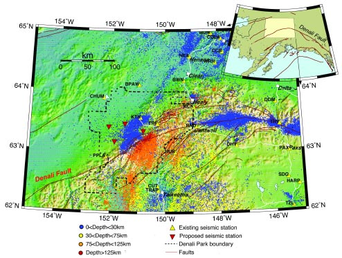
It is clear that many earthquakes occur on structures (faults) that radiate from or are parallel to the Denali Fault. The more interesting question is to understand why the Kantishna cluster is more active than the other major features in the area, including the Denali fault.
Is it possible that motion associated with the Denali fault system is being redirected to other active features? How is this motion related to the uplift associated with Denali? The recent magnitude 7.9 Denali fault earthquake provides additional motivation to understand the seismicity in the region. Will the rupture of the central segment of the Denali fault have a noticeable effect on the western section of the fault running through the park? Will the western section of the Denali fault rupture in the near future producing another large earthquake? Broader questions include: What factors contribute to the continued growth of Denali? Is there a relationship between the Kantishna cluster, the Minto Flats Seismic Zone, and the McKinley cluster?
Answers to these questions will come from careful analysis of the seismic observations of the earthquakes and associated deformations. To accomplish this, AEIC has been upgrading and expanding the seismic network in Denali and the surrounding area. Currently, there are three seismic stations installed in the park, with another seven surrounding the park. In order to observe the seismic wavefield from an earthquake for advanced analysis we need stations every 6 to 12.5 miles (10-20 km). Future plans are to move in this direction, particularly around the Kantishna area and Denali fault. The first step is a new station to be installed to the west of Kantishna in summer 2006.
Through the partnership between the park and AEIC, much of the Denali Seismic Network will be available for use in the Murie Science and Learning Center. This will create the opportunity for public education on how seismic waves are recorded, analyzed, and used in research to study tectonics and earthquakes. Park staff have already been instrumental in the deployment, maintenance, and telemetry of the seismic stations and data, and continued interaction will expand public displays and presentations related to this ongoing research.
Part of a series of articles titled Alaska Park Science - Volume 5 Issue 1: Scientific Studies in Denali.
Last updated: October 23, 2021
