By By Dennis R. Lassuy, John F. Payne, and Robert A. Winfree

Bureau of Ocean Energy Management (BOEM)
The North Slope Science Initiative (NSSI) is leading an effort to use scenarios to envision the plausible future story of development on Alaska’s North Slope and the adjacent waters of the Beaufort and Chukchi Seas (Figure 1). Scenarios will help NSSI to identify the appropriate science strategies to invest in now to better inform management decisions in the future. The NSSI was collectively formed by federal, state, local, and Native entities in Alaska and formally authorized under the Energy Policy Act of 2005, to serve as an intergovernmental forum for science collaboration. The NSSI is administered through the Bureau of Land Management, a major land resources manager on the North Slope. The National Park Service is an active federal member and has recently chaired the group’s governing board.

Doug Kane, UAF
With over 203,000 square miles (526,000 square kilometers) of land and sea, the North Slope and its adjacent seas are believed to hold some of the largest remaining oil (Figure 2), gas, and coal potential in the United States. These areas are also home to a diverse array of fish (Figure 3), wildlife (Figure 4), and plant resources that support a vibrant subsistence culture. Future development on the North Slope and the Beaufort and Chukchi Seas could be shaped by many forces and many voices. Energy demand and alternative sources, new oil and gas finds, local needs, oil prices, social priorities, food security (Figure 5), climate change, international politics—all of these and more may come into play. Key stakeholders will include the communities of the North Slope, energy and resource extraction and related industries, academia, conservation organizations, and the Native, local, state, and federal resource managers of the North Slope Science Initiative.

Gordon Brower, North Slope Borough
The use of scenarios is an effective exploratory and analytical approach in complex and uncertain situations. “Complex” and “uncertain” are good descriptors for the Arctic and its future. In Alaska, scenarios have recently been applied to questions about marine shipping (Arctic Council 2009), climate change (Winfree et al. 2013), port site selection, and now energy and resource development.
Scenarios will be used by NSSI in a deliberative and inclusive process that engages these diverse stakeholders in thinking creatively about plausible futures. The NSSI recognized the need for this dialogue and has recently begun a scenarios process as one approach to “Integrated Arctic Management” (Clement et al. 2013). The elicitation of development scenarios and an analysis of their potential implications will help prepare U.S. Arctic managers to make informed decisions about the needed research and monitoring. U.S. Arctic managers will need this science to help sustain natural resources and plan for safe energy and resource development in the face of impending changes.

Brian Person, North Slope Borough
The process will move from scenarios to strategies. All involved will help develop the plausible stories (scenarios) of future U.S. Arctic development. Then we will assess the science needed to understand the implications of each scenario so that regardless of which scenario comes to pass, U.S. Arctic resource managers will be prepared with strategies to collect the appropriate information to make effective decisions.
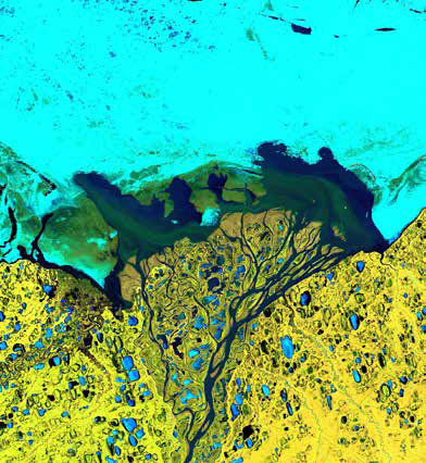
Early in NSSI’s assessment of the state of the science for the North Slope and adjacent seas, its Science Technical Advisory Panel (STAP) and Senior Staff Committee prepared a series of “Emerging Issue Summaries.” Broad topics like sea ice conditions (Figure 6), permafrost (Figure 7), hydrology (Figure 8), increasing marine activities (Figure 9), and several others were identified by the NSSI Oversight Group (its governing board), and then questions and specific issues related to each broad topic were developed by experienced agency scientists. The STAP developed the emerging issue summaries through an iterative process that combined input from agencies with information from external subject matter experts.

Gordon Brower, North Slope Borough
In compiling these summaries, the STAP recognized a number of “connectivities” (similarities and linkages between the kinds of information required to address science needs across a number of topics). They also published a paper in the journal Arctic, in which they laid out a number of “overarching priorities” (Streever et al. 2011). First among those overarching priorities was a “systematic assessment of the range of potential development scenarios” for the North Slope and adjacent seas “in a manner that will contribute to refinement of specific research priorities.” The individual issue summaries provided excellent information on the current state of the science and existing information gaps. However, the STAP felt that more was needed in the face of increasing pressure for energy development and a rapidly changing environment. A high priority was an analysis of plausible future conditions to help understand what agencies’ future science needs may be and the context in which that science may be developed, undertaken, and used. In short, scenarios were “important for prioritizing and implementing temporally and spatially appropriate research and monitoring.”

NOAA
To address this priority need, a cooperative agreement was entered into in late 2013 between the NSSI and a team formed by personnel from the University of Alaska Fairbanks (with their extensive Arctic and North Slope experience) and GeoAdaptive LLC (a consulting firm with vast experience in participatory scenarios projects and geospatial analysis). Materials on the scenarios project are available online.
The materials posted on the NSSI website provide some general background on what scenarios are and how they have been used. However, scenarios are basically descriptions of how the future may unfold—often in the form of narratives, accompanied by graphic representations of what each scenario may generally “look like” on-the-ground/in-the-water. The process of developing those scenarios allows us to consider, in an informed, inclusive, and systematic way, a range of potential alternative conditions under which management decisions may play out in an uncertain future.

Ben Jones, USGS
In order to be realistic in assessing what the shapes of those scenarios may be and which among them are truly plausible, the process is informed by first reviewing and synthesizing current knowledge (building on the past and present to help understand the future) and projections of expected changes (e.g., models). The process is inclusive (gathering input from diverse sources of knowledge and thought) in order to think broadly and help understand the full range of factors that may influence, or be influenced by, the direction of future changes.
The process is systematic because it requires that we organize and assess our assumptions, compare and contrast a range of potential drivers of change, and consider the internal consistency of the scenarios that emerge from the analysis. A general depiction of the scenarios elicitation process is presented in Figure 10.

USGS
The above description is where many scenario processes stop, leaving the discussion of scenarios and their implications to the involved parties (e.g., companies, agencies, or organizations) to use as they see fit. For the North Slope Science Initiative, however, it’s all about the science and being agile enough in our science strategies to be able to inform management decisions under any plausible scenario. The NSSI scenarios project will therefore move beyond this by having a diverse group of scientists and other knowledge holders undertake an analysis of the scenarios and implications that the broader group of stakeholders has produced.

NPS Photo / Robert A. Winfree
The priority product of this additional analysis is scenario-informed guidance on what kind of research (Figure 11) and monitoring (Figure 12) will be needed to detect, assess, and respond to the identified range of plausible development-driven changes on the North Slope and adjacent seas. This approach allows decision makers flexibility to monitor and adapt to unexpected events. However, it is also important to consider that one of the most important short- and long-term benefits is that the scenarios process itself can strengthen the level of shared understanding among an involved and informed community of stakeholder participants.

As the North Slope Science Initiative scenarios project progresses, occasional updates and eventual outcomes will be shared in future issues of Alaska Park Science. The project is expected to be completed by the fall of 2015.
Ben Jones, USGS
References
Arctic Council. 2009.
Arctic Marine Shipping Assessment 2009 Report. Second Printing. 194 pp. Download this report
Clement, J.P., J.L. Bengtson, and B.P. Kelly. 2013.
Managing for the future in a rapidly changing Arctic. A report to the President. Interagency Working Group on Coordination of Domestic Energy Development and Permitting in Alaska (D. J. Hayes, Chair), Washington, D.C., 59 pp. Download this report

Terri Lomax, ADEC
Streever, B., R. Suydam, J.F. Payne, R. Shuchman, R.P. Angliss, G. Balogh, J. Brown, J. Grunblatt, S. Guyer, D.L. Kane, J.J. Kelley, G. Kofinas, D.R. Lassuy, W. Loya, P. Martin, S.E. Moore, W.S. Pegau, C. Rea, D.J. Reed, T. Sformo, M. Sturm, J.J. Taylor, T. Viavant, D. Williams, and D. Yokel. 2011.
Environmental change and potential impacts: Applied research priorities for Alaska’s North Slope. ARCTIC, 64(3):390-397.
Winfree, R., B. Rice, J. Morris, J. Mow, D. Callaway, D. Weeks, N. Fresco, and L. Krutikov. 2013.
Climate change scenario planning lessons from Alaska. Alaska Park Science. 12(1) 74-79.
Part of a series of articles titled Alaska Park Science - Volume 13 Issue 2: Mineral and Energy Development.
Last updated: June 15, 2015