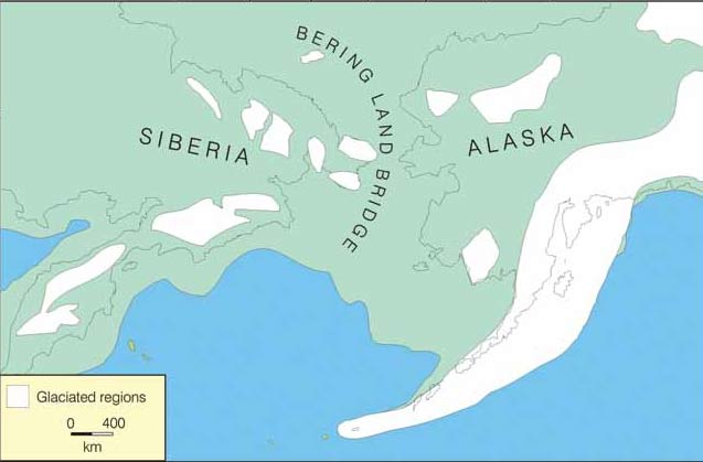
If you live in Alaska, you may or may not be aware that you are living in the remnants of a once vast super-continental region called Beringia. The name ‘Beringia’ comes from the Bering Strait, and it is used to describe an enormous territory that extended from the Lena River (Siberia) in the west to the Mackenzie River (Yukon) in the east. The western and eastern sectors of Beringia were joined together by the Bering Land Bridge

The Bering Land Bridge formed during the glacial periods of the last 2.5 million years. Every time an ice age began, a large proportion of the world’s water got locked up in massive continental ice sheets.
This draw-down of the world’s liquid water supply caused major drops in sea level: up to 328’ (100 m) or more. Because the basins beneath the Chukchi and Bering seas are relatively shallow, they became dry land during glacial intervals. For perhaps 80% of the last million years, Alaska has been joined to Siberia by this land bridge.
The land bridge did more than link the two continents. It also ushered in a new climatic regime to the entire Beringian region by blocking Pacific moisture from entering the interior regions of both Alaska and north-eastern Siberia. Thus these regions became much drier than they are today. In fact they became so dry that their lowlands remained ice-free, even during the coldest climatic episodes of the ice ages. While virtually all of the rest of Canada, parts of western Siberia, and much of northern Europe were buried ice during glaciations, Beringia remained ice-free, except for the mountain regions that managed to catch enough moisture to build up a heavy snowpack. This made Beringia unique: a high northern region without ice cover. It could therefore serve as a refuge for arctic plants and animals, and in fact many arctic species did survive the ice ages in this refuge.

NPS Photo
Beringian Fossils
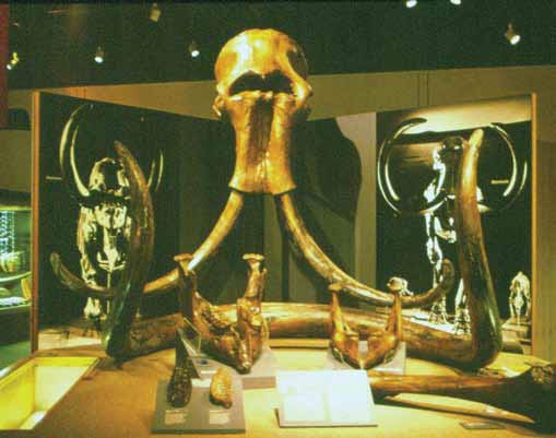
Beringia was home to an amazing menagerie of large woolly beasts, such as the woolly mammoth, woolly rhinoceros (on the Siberian side of the land bridge), giant short-faced bear, scimitar cat, and Pleistocene camels, horses, bison and musk-oxen. The skeletons (and sometimes mummified remains) of these Beringian beasts fill museum displays from Anchorage to Whitehorse.
But they were not the only animals who lived in Beringia. My interest is in the small critters: the insects that were buzzing around the landscape. Beetles, in particular, are hard-bodied insects that preserve well as fossils in the kinds of organic-rich sediments commonly found along the high river banks of Alaska’s streams and rivers. Because of permafrost conditions, the fossils I examine have most often been frozen since the first winter after they died, even if that winter took place a million years ago.
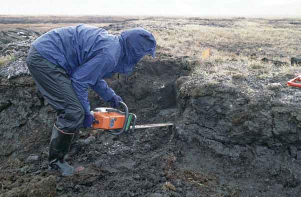
Frozen sediments preserve insect skeletons (theirs are on the outside, while ours are on the inside) extremely well – so much so that a fossil beetle that is upwards of a million years old looks as if it died in the last century or two. Now sometimes it is extremely difficult to get this frozen sediment out of the ground. It can be as hard as concrete. I have had to resort to using chain saws to cut blocks of peaty sediments out of the ground (Figure 2). A colleague of mine even tried dynamite! But in the end, such efforts are rewarded by a treasure trove of shiny, highly decorated beetle ‘bits’ that I can study and identify under the microscope.
Beetles are the largest group of insects on the planet. We do not have an exact count, but recent estimates of the beetle fauna put the total number of species at about 1500 that live in Alaska (Anderson 1997). This represents three-quarters of the number of all the Alaskan plant species (Hultén 1968); it is more than triple the number of birds (Armstrong 1995), and about fourteen times the number of mammal species.
So the beetles are out there – in large numbers – telling us things about the landscape by where they live, what they eat, how cold they can take it in the winter, and how warm they need it to be in the summer. In fact their relatively high diversity in Alaska is, itself, a product of their longevity in the Beringian refuge.

The Nature of Beringia
Eastern Beringia, the unglaciated lowlands of Alaska and the Yukon, was not a barren arctic wasteland during the last glaciation – far from it! Instead, it was a very productive landscape, dominated by grasses and other herbs, mixed with arctic tundra plants. This ecosystem has been called ‘steppe-tundra,’ and it was extremely widespread, from the Yukon region in the east, all the way across the unglaciated parts of Siberia, to the unglaciated parts of Western Europe. The steppe-tundra supported a wide range of large grazing mammals and their predators. Herds of Pleistocene camels, bison, horses, mammoths, and musk-oxen grazed the dry grasslands of interior Alaska and the Yukon. All but the musk-ox died out at the end of the last glaciation, between about 15,000 and 11,000 years ago. But running around beneath the feet of these ice-age behemoths were hundreds of species of beetles. None of the steppe-tundra beetle species became extinct. They survive today, although some of them now live in different regions than they did in the ancient past. By studying their modern ecology, we can piece together what the ancient Beringian landscapes were like.
One of the puzzles that intrigues Beringian scientists is the actual extent of the steppe-tundra ecosystem. How much of Alaska did it cover? Did it spread out onto the Bering Land Bridge, or was that region covered by some other kind of vegetation? Did it form a continuous band of grassy landscapes that linked Western Beringia (unglaciated northeastern Siberia) to Eastern Beringia, or was there an ecological gap between the two mega-regions? I have been fortunate enough to be able to address some of these questions in my fossil beetle research. It turns out that there are beetle species that are quite characteristic of the steppe-tundra habitat. Some of these are plant feeders associated with the semi-arid steppe-tundra vegetation, such as beetles that feed on sage brush. Some are predators that live today on the cold grasslands of north western Canada. On the flip side of the equation, there are also groups of beetles that are completely unsuited to steppe-tundra, but flourish in the low shrub tundra habitats we see today in north western Alaska. Thus, by identifying which groups of beetles are found in a fossil assemblage, it is relatively easy to identify which ecosystem existed at the time and place the beetles were living. There is a beetle ‘signature’ on the landscape that can differentiate between the different ancient ecosystems.

Fossil Sampling
As we all know, Alaska is an enormous state, and much of it cannot easily be reached except by float plane or helicopter (very expensive means of transportation). So unlike some other parts of the world, where fossil study sites dot the landscape like a veritable pin cushion, the number of fossil study sites in place like western and northern Alaska are few and far between.
Nevertheless, some patterns are emerging that are shedding light on the steppe-tundra question. One of the most fascinating sources of fossil materials has been cores of sediment that were drilled from the sea bed in the Bering and Chukchi Seas. Back in the 1970s and 1980s, the U. S. Geological Survey commissioned a study of the geology of the Chukchi and Bering Sea beds, mostly as an aid to the development of oil and gas supplies. The USGS punched holes into the sea floor in many localities, taking cores that went down into the Cretaceous in some cases (where the oil and gas deposits are to be found).
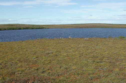
But at the very tops of those cores, a meter or more of soft sediments were sampled. Those sediments accumulated on the surface of the Bering Land Bridge, during the last ice age. Colleagues and I were able to sample organic-rich sediments that contained plant detritus, pollen, and insects that had lived and died on the land bridge. Out of the thousands of cores taken by the USGS, we were able to find Late Pleistocene fossils in about 20. The peaty sediments we studied most likely accumulated in shallow ponds or bogs on the land bridge.
What Was the Land Bridge Like?
Our results, combined with those of other scientists, are starting to reveal an interesting pattern (Elias et al. 1996). Most of the ancient ecosystems we studied from the land bridge were quite similar to what is found in north western Alaska today. This is called mesic tundra: low tundra vegetation that requires a medium amount of moisture to grow.
It is dominated by dwarf shrubs of birch and willow, mixed with tundra herbs. There is very little grass in it – not enough to feed a hungry mammoth, for instance. This zone of mesic tundra covered much of the central and northern parts of the land bridge, and it extended east onto parts of upland Alaska, but not in a uniform pattern. Parts of south western Alaska around the Bristol Bay region were dominated by mesic tundra, as well as much of north western Alaska.
But parts of the Seward Peninsula clearly had a cover of steppe-tundra. Furthermore, some of the modern-day islands in the Bering Sea, including St Lawrence Island, had steppe-tundra vegetation. These islands would have been highlands overlooking the broad plains of the ancient land bridge. So the pattern that is emerging is that much of the center of Beringia – the land bridge – was wetter than the surrounding uplands on either side. Paleontologist Dale Guthrie (2001) has called this the buckle in the steppe-tundra belt.
This wetter region, with its dwarf-shrub cover, may have posed a barrier to migration for some (but not all) of the large grazers that lived on either side of the land bridge. For instance, the woolly rhinoceros lived throughout Western Beringia, as well as other grassy parts of Eurasia, during the Late Pleistocene. This rhino made it right up to the edge of the Bering Land Bridge, but it did not manage to cross over (Elias and Crocker 2008). Its feet were adapted to firm, dry ground, and it needed large quantities of grasses to survive, so it may have shied away from the damp, shrubby land bridge. But the land bridge did not prevent other species from migrating across. The woolly mammoth, for instance, managed to live on both sides of Beringia.
Alaskan national parks have provided many of the fossil sites used in the study of ancient Beringian landscapes and ecosystems. Important sites have been studied in Denali National Park, Gates of the Arctic National Park and Preserve, Noatak National Preserve, Bering Land Bridge National Preserve, and Katmai National Park and Preserve. Park Service scientists have worked in collaboration with researchers from the U. S. Geological Survey and various universities in Alaska and the lower 48 states to develop Beringian studies. One aspect of the research that interests all parties is the human story.
When did our species enter the New World? Did they use the Bering Land Bridge to get here, or did they embark from Asia by canoe, and paddle along the Pacific coast of the Americas? What were the conditions like when they first arrived in Alaska? As discussed in a recent book by Hoffecker and Elias (2007), the human story cannot be separated from the environment. Perhaps these little beetles have as much or more to tell us about about ourselves than do the big beasts!
Part of a series of articles titled Alaska Park Science - Volume 12 Issue 2: Climate Change in Alaska's National Parks.
Last updated: August 11, 2015
