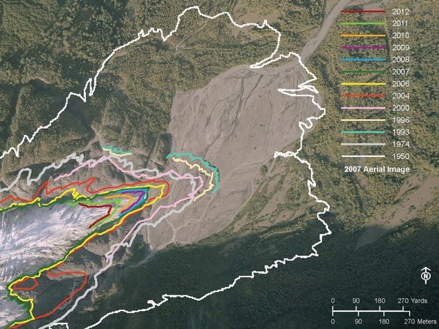
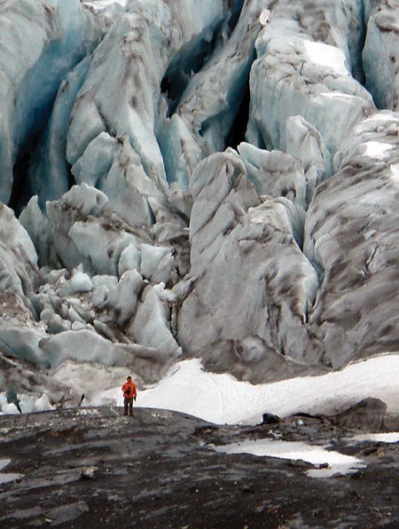
Until fairly recently, most National Park Service (NPS) planners, engineers, and architects had not factored climate change into their designs for projects in Alaska. Planners relied on the Environmental Atlas of Alaska (Hartman and Johnson 1978) as an important reference for 35 years, but the book is now out-of-date and out-of-print. Conditions in Alaska are not static. Fortunately, permafrost thaw was a major consideration for the design and construction of the Trans-Alaska Pipeline System (built in 1974-77), but planning based on past environmental conditions created problems for other facilities and infrastructure projects that were constructed both before and after the pipeline project. For examples, roads, residences and other structures in the Fairbanks, Alaska area have tilted or buckled where permafrost thawed beneath them. The U.S. Forest Service visitor center at Portage Lake originally featured views of Portage Glacier calving into the lake, but the glacier has since retreated from view. Visitors come to Exit Glacier in Kenai Fjords National Park for up-close iconic views of the glacier, but the glacier terminus has thawed back rapidly in recent years, causing NPS to chase the retreating glacier (Figures 1 and 2) with trail extensions. Planners and designers have previously assumed a somewhat static environment, but as these and other examples show, such is not the case today.
Rapidly changing conditions in the Arctic are due largely to sea ice retreat and reduced albedo in summer (Comiso et al. 2008, http://www.nasa.gov/topics/earth/features/2012-seaicemin.htmlreferences), which feeds back to accelerate melting of snow, ice, and permafrost in the area. Climate-induced changes in Southcentral and Southwestern Alaska have slowed in recent years, presumably because of a switch in the Pacific Decadal Oscillation (PDO) from a warm phase, from about 1976 to about 2006, to the cold phase of the PDO in recent years (Wendler et al. 2012). Though winters and summers have been cooler in the southern parts of Alaska in recent years, glaciers have continued to retreat overall from previous decades (Molnia 2008, Molnia and Puckett 2008, and McKittrick et al. 2011). Increased precipitation in the southern half of the state onto recently deglaciated terrain and unvegetated barrens with reduced water storage has resulted in increased potential for flashy hydrological conditions (http://en.wikipedia.org/wiki/Retreat_of_glaciers_since_1850#Alaska, http://www.wunderground.com/climate/Glaciers.asp#Header1_6).
In the southern half of the state, the NPS has been contending with higher risks of flooding or other effects from glacial retreat. In coastal areas storm surges on top of sea level rise, tidal fluxes, and permafrost thaw, which has been monitored across the Alaska for a few decades (Romanovsky et al. 2012 and Ostercamp 2008), have increased risks to natural and cultural resources and infrastructure in these areas.
Increased incidence of beetle-killed trees, presumably resulting from warmer winters (Juday and Marler 1997, Juday et al. 1997, http://www.cgc.uaf.edu/newsletter/gg6_1/beetles.html, http://e360.yale.edu/feature/whats_killing_the_great_forests_of_the_american_west/2252/, http://www.usgcrp.gov/usgcrp/nacc/education/alaska/ak-edu-refs.htm) and dry warm summers have resulted in massive wildland fires in Interior and Southcentral Alaska. Two of the three largest fires seasons on record occurred in 2004 and 2005, burning about six million and 4 million acres, respectively.
Federal Policies on Climate Change and Environmental Analysis
NPS Photo
In 2009, NPS issued interim guidance for considering climate change in environmental analysis (NPS 2009), and recommend that two key questions be addressed:
- What is the contribution of proposed project to climate change, as indicated by greenhouse gas emissions associated with the project?
- What is the impact of climate change on park resources, and specifically, the resources that will be impacted by the project?
The White House Council on Environmental Quality’s Draft NEPA Guidance on Consideration of the Effects of Climate Change and Greenhouse Gas Emissions also recommended for consideration of climate change in NEPA analyses of environmental effects and reasonable alternatives to mitigate impacts, including:
- The greenhouse gas emissions effects of a proposed action and alternative actions; and
- The relationship of climate change effects to a proposed action or alternatives, including the relationship to proposal design, environmental impacts, mitigation, and adaptation measures.
In November 2012, NPS Director Jon Jarvis released the National Park Service Climate Change Action Plan (NPS 2012a). The goal of the plan is to build flexible, coordinated capacity to deal with climate change. This plan lays out “no-regrets” actions that parks can take now and in preparation for future conditions. Jarvis stated, “While the plan lays out specific actions, flexibility is a key component. Even as we embrace the uncertainties and dynamic nature of climate change, we know that new information, technologies, and ideas will emerge over the coming years to help us respond. The National Park Service is making changes in its operations because of what we’ve learned about climate change.”
An expanding body of empirical evidence and national policies make it clear that climate change needs to be considered and factored into a wide range of project planning including but not limited to: the design and location of buildings, roads, and trails; management of wildland fires; and in natural and cultural resources management (see DeGange et al. and Winfree et al. in this issue). This article focuses on examples from planning for wildland fire management, facilities design, and road and trails location.
Wildland Fire
Historical evidence and modeling indicate that woody vegetation, shrubs and trees, are expanding to higher altitudes and higher latitudes with more frequently and widespread incidence of forest pests and diseases (Vose et al. 2012). University of Alaska Scenarios Network for Alaska/Arctic Planning (SNAP) modeling indicates high probability of warmer and drier conditions in the future. With warmer and drier conditions, the potential for fire is likely to increase. More area burned in Alaska in the last decade than the previous 50 years of records (Kasischke et al. 2010), although this was largely driven by the fire seasons of 2004 and 2005. Evidence also suggests that environmental changes in the Arctic may be affecting tundra fire regimes. For example, during the summer of 2010, thirty-seven fires occurred in the Noatak National Preserve, the largest number of fires occurring in this area since record keeping began in 1950. Three years prior, the Anaktuvuk River Fire on Alaska’s North Slope, more than doubled the recorded area burned north of the Brooks Range (Higuera et al. 2011). Although wildland fires have not been nearly as dramatic since 2004/05, NPS recognizes that severe conditions could return any year, and it is best to be prepared.
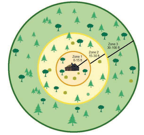
The NPS Alaska Region is currently preparing an environmental assessment to address a management plan to reduce hazardous vegetative fuels within several parks in Alaska (not to include Denali National Park, which already has such a plan in place, or Southeast Alaska rainforest areas). The plan proposes to conduct hazardous fuel reduction projects around infrastructure, values at risk or near communities adjacent to park lands in order to provide defensible space and to help mitigate wildfire risks. This plan builds upon existing park fire management plans and the Alaska Interagency Wildland Fire Management Plan of 2010. Specifically the plan proposes to adopt Alaska Firewise concepts to clear fire-prone vegetation with appropriate methods from around structures in developed areas (Figure 4) and remote backcountry settings. Furthermore, the NPS is considering whether, where, and when to use prescribed fire to enlarge protection zones around structures set amid particularly fire-prone vegetation types such as black spruce or beetle-killed white spruce.
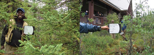
The NPS Fire Management program has reduced hazardous fuels around the Denali Wilderness Access Center as part of a front country fuels reduction project to reduce the risk of wildfire (Figures 5 and 6). The pre-treatment photo on the left shows thick, flammable spruce and the photo on the right shows one year post treatment with the spruce cleared adjacent to the building. The fire ecology program has monitored these sites to determine effectiveness of the fuels project.
Facilities
NPS Photos
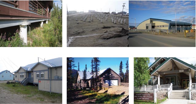
In Denali National Park and Preserve and in Arctic NPS areas, several buildings have been constructed with consideration of permafrost thaw. The Wilderness Access Center near the entrance to Denali National Park was constructed on “warm” permafrost with a ground temperature just under 32 °F (0°C), also known as the melting temperature. The designers recognized that a slight warming of the ground due to climate change or human activities could result in the complete thawing of the permafrost on which the foundation was built. Consequently, the building was constructed on driven piles with provisions to add refrigerant cooling, if needed, into the pilings (Figure 7).
The relatively new Northwest Alaska Heritage Center in Kotzebue, Alaska was built on driven hollow pilings in an area known to have permafrost (Figure 8). The completed building is elevated completely off the ground and insulated all around. Park housing duplexes for Bering Land Bridge National Preserve in Nome, Alaska were similarly built on pilings driven into permafrost-rich ground (Figure 9). Housing for Gates of the Arctic National Park and Preserve employees in Coldfoot, Alaska (one of the coldest spots in the nation), is constructed on adjustable post and pad foundation to account for changing permafrost conditions (Figure 10).
Permafrost is discontinuous or absent in South-Central Alaska, south of the Alaska Range, except under glaciers. Talkeetna, Alaska, where the Denali climbing rangers base their operations, is located within a floodplain. Here, the NPS visitor and climbing center was built upon an elevated pad and hardened base (Figure 11). The value of forward-thinking design became very clear in September 2012, when a 100-year flood inundated Talkeetna and the surrounding lowlands, devastating many homes and businesses. The ranger station was spared major damages. In spring 2013, the community was again bracing for flooding, with radio programs broadcasting for emergency preparations. Community leaders also requested scenario planning assistance from NPS to prepare for future extreme events.
The land in Glacier Bay National Park and surrounding areas of Southeast Alaska is responding to glacial retreat in a much different way than in Northern Alaska. Here the land has been measured to be rebounding at a rate of about 2 in (5 cm) a year. This effect (isostatic rebound) is a geologic readjustment to tremendous weight removed from the Earth’s crust by melt and retreat of the land-based and tidewater glaciers from within the park and surrounding areas. Although sea level is also rising from freshwater inflows and thermal expansion, land surfaces in some areas of Southeast and Southwest Alaska are currently rising even faster. The NPS is preparing to construct the Huna House on the shores of Bartlett Cove near park headquarters (Figure 12). The NPS Development Advisory Board considered elevating the building to account for sea level rise, but concluded that relative sea level rise was not an issue in this particular location. The land around Bartlett Cove is actually expected to rise relative to adjacent sea level for the foreseeable future, due to isostatic rebound. Although a design change was not needed in this case, this example shows the importance of conducting a reasonable assessment of the plausible effects of climate change.
Sea level rise, storm surges, and coastal erosion are severe issues for coastal communities in Western and Arctic Alaska, such as the village of Shishmaref, which is situated amid coastal segments of Bering Land Bridge National Preserve. Thawing permafrost, progressive sea ice retreat, and delayed onset of sea ice formation during fall storm seasons have resulted in the exposure of Shishmaref and other coastal communities to devastating coastal erosion and/or flooding, which threaten buildings and lives (Figure 14). Shishmaref has garnered international press over their plight, and they are requesting funds to reinforce their shoreline with massive rock revetments to buy time for eventual relocation. Both options are extremely expensive, and reduced federal funding complicates the village relocation efforts. With assistance from the State of Alaska, Shishmaref has investigated construction of a road across NPS lands to Native-owned lands at Ear Mountain, where construction materials could be mined and moved to reinforce the existing village site or to a future village site. In this example, we see how climate change pressures on a community outside an NPS area could also lead to environmental impacts (road construction) within the Preserve itself.
Roads and Trails
NPS Photos
Addressing the impacts of climate change to park transportation systems is one of the five key goals for NPS in the Long-Range Transportation Plan for Alaska (NPS 2012b). This plan calls for science, adaptation, mitigation, and communication to address impacts on transportation, and also emphasizes implementing performance measures. Scientific research, monitoring, and a proposed Vulnerability Assessment for Alaska Transportation Infrastructure are needed to understand and respond to climate change challenges to transportation systems in Alaska units. Adaptation is needed to manage existing transportation assets and to plan for new systems in face of climate change. Mitigation will help NPS reduce its carbon footprint associated with park operations and visitation. Communication involves sharing compelling stories about climate change with the public as related to transportation.
The Exit Glacier Road in Kenai Fjords National Park (located between mileposts MP 7 and MP 8), is frequently flooded from the Exit Glacier drainage. This section of the road had not previously been observed to flood during mid-summer months. Over time the flood changed from infrequent to more of an annual expectation during fall of the last couple of years. Here, flooding appears to be associated with intense storm activity and/or increased melt and runoff from Exit Glacier, which damages the road and impedes visitor access to the Exit Glacier area. Park managers also suspect a changing hydrologic regime in the area, possibly due to massive amounts of outwash material deposited in the outwash plain below receding Exit Glacier and in Exit Creek delta with its braided streams. These changes contribute to massive water flows that overwhelm the road (Figures 15 and 16). While new studies are being conducted to verify presumed causes of the unusual flooding events, the NPS is also redesigning the road to address the recurring problem.
In Denali National Park, mud and vegetation slumps onto the Denali Park Road “more frequently and aggressively than in the old days” according to long-term east district road maintenance foreman Tim Taylor. The park road was cut into mostly south-facing slopes where permafrost lays at depth beneath, but other contributing circumstances have also been building for decades. Clearing and widening of road ditches and annual clearing of culverts of debris, may have led to more thaw and sliding of vegetation above permafrost beds. In places, huge cracks have opened in the tundra above the road, and some slumping has also occurred below the road. One example of these events is at mile 20.5 of the park road (Figures 17 and 18), where maintenance workers are responding with fixes to minimize road closures. The NPS recognizes that human activities play a role in these events, but with his 33-years’ park experience to draw on, Taylor says these slumps are now more frequent, widespread, and larger than decades before. He suspects that something bigger is affecting the road. Ongoing NPS natural resources inventory and monitoring may help to reveal the answers.
In summary, Alaska’s national parks face new and unexpected planning, design, and maintenance challenges as we enter a new era of climate change. It behooves the NPS to pay attention to these changes and plan and act accordingly. Foresight and flexibility are extremely important in dealing with highly uncertain future conditions, including changes resulting partly or wholly from climate change. A temporary cold phase of the PDO appears to have recently slowed or reversed recent warming trends south of the Arctic, as compared to previous decades, but atmospheric changes are still occurring. Localized cooling trends could quickly reverse or be overwhelmed by wider-scale changes. Nimble and prudent planning, and preparations for plausible future conditions resulting from climate change effects, are warranted and desirable.
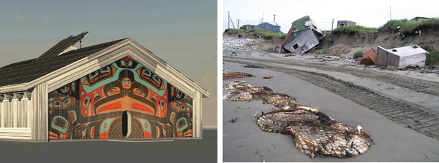
Figure 12 (above left). Glacier Bay Huna Tribal House Site will be built next to ocean, but the surrounding land is expected to rise more quickly than sea level in coming decades due to iso-static rebound in this area.
Figure 13 (above right). Storm damage along shore at Shishmaref, Alaska. In Shishmaref, Alaska, where there is an ongoing battle with the rising sea, seawalls made of various materials are being constructed as houses are undermined by severe erosion on the coastline. A wall made of sandbags was the first attempt to keep the water out. Local resident Heather ‘’Anunuk’’ Sinnok shares her frustration as part of the Por-traits of Resilience project: ‘’How are sandbags going to help us? We’re made out of sand!! We had such high hopes for the second wall made of cement blocks.’’ The second wall also had little success, and is now sinking into the thawing permafrost beneath the island.
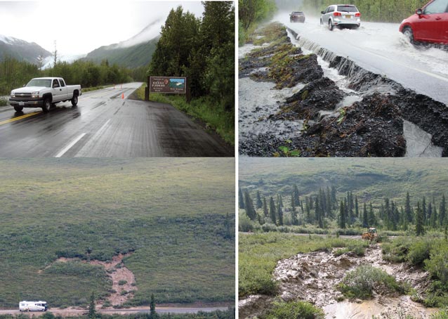
Clockwise, from top left:
Figure 14. NPS photograph of Exit Glacier Road during high water event in 2009.
Figure 15. Flood waters washing over Exit Glacier Road in 2010.
Figure 17. Maintenance at hillside slump at Mile 20.5 of Denali Park Road, August 1, 2005.
Figure 16. Hillside slump impedes traffic at mile 20.5 of Denali Park Road, August 1, 2005.
Part of a series of articles titled Alaska Park Science - Volume 12 Issue 2: Climate Change in Alaska's National Parks.
Last updated: October 23, 2021
