The objective of any search and rescue (SAR) mission is to locate and provide aid to persons who are missing and feared to be in distress. A priority during this type of operation is to minimize loss of life, injury, and property loss or damage of the missing subject as well as mitigate similar risks to rescue personnel. A SAR incident manage-ment team can employ geographic information systems (GIS) to evaluate the current situation and manage the search operation. Maps provide a visual reference that otherwise might be difficult to describe. And by reviewing and analyzing geospatial data, including real-time data collected during the mission, the management team can make better informed decisions when planning search strategies and scheduling resources. Ultimately, the use of GIS during a SAR mission may reduce operational costs and response times by allowing for a systematic approach to searching an area of interest (US Coast Guard 2009).

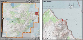
The NPS Alaska GIS community provided valuable support during the Branch SAR effort in Katmai National Park and Preserve, after a single engine floatplane carrying three NPS employees and a pilot went missing on August 21, 2010, near Swikshak Bay (Figure 3). Geospatial technologies were integrated into the daily operations as new search data were collected, analyses were performed, and updated maps were generated. The SAR GIS team processed a daily workflow and worked with the Incident Commander and Planning and Operations sections to develop re-usable tools for use during and beyond this single incident. The Branch SAR GIS was kept current with the most recent data at all times and was utilized in the daily planning process to provide situational awareness and safely maximize resources.
During a SAR mission, visualizations are frequently requested. To create timely and effective maps, a SAR GIS team must have access to accurate and relevant base data, as well as mission data that has been captured on handheld Global Positioning System (GPS) units. Since a SAR operation is time critical and the data being collected is always changing, a structured geo-spatial workflow and file structure must be established early in the operation; it should include the retrieval and integration of newly collected data also.
During the Branch SAR effort, the SAR GIS team and Alaska Region GIS team worked together to assemble the most current and useful base data to underlie the mission data. By integrating existing imagery and other data already in the NPS Alaska GIS data stack with newly received data from GeoEye, FAA, and military sources, the SAR GIS team was able to establish “best available” base layers on which to build maps and perform analyses.
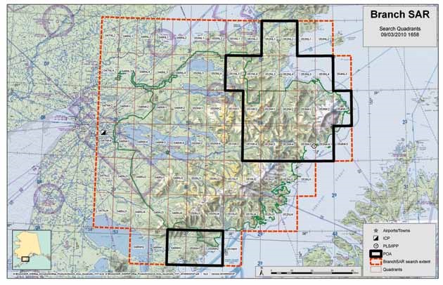
With base layers established and mission reporting data constantly updated, GIS was used to plan air operations: search missions did not overlap, and the search area had comprehensive coverage. During pilot briefings each morning, pilots received custom quadrant maps of their individual search areas for the day. The SAR GIS team developed a script to automatically create these 84 customized maps so that the map series could be easily regenerated with different base layers and features, to emphasize specific topographical elements and search focuses.
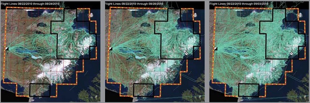
Each search aircraft also carried a GPS unit specifi-cally for tracking the day’s flight path. After the data was downloaded from the units each night, it was combined with aircraft tracks from that day and all previous days to produce a cumulative dataset (Figure 1). In addition to the information generated by the GPS units, the SAR GIS team populated valuable attribute information such as pilot name, aircraft tail number, and conditions that were encountered during the flight. Information on the prob-ability of detection in the areas covered were recorded on pilot debrief forms and entered into the geospatial database. This was then related back to the flight lines and search areas. The maps that were most useful to the SAR Incident Management Team integrated this data with elevation data and annotated satellite imagery to provide an accurate depiction of the search progress along the area’s landforms, vegetation, and other resources.
Not only were daily maps generated to produce current visualizations of the search progress, but the underlying data was used to help spatially analyze the search area coverage. Initially, pilots searched areas based on terrain and the most likely routes the missing aircraft may have taken. As more resources became available, a more methodical approach was taken, where pilots flew one mile intervals across 15 minute (9 x 17 mile) quadrants in both the north-south and east-west directions forming a grid-like pattern of flight tracks. By examining all these flight paths and determining the areas between intersecting tracks of the searching aircraft, the SAR GIS team developed custom analysis to show the overall search density (Figure 2). This information was updated and visualized on daily maps and used alongside maps displaying the current probability of detection to help the planning and operations sections determine where to send resources for additional searching.
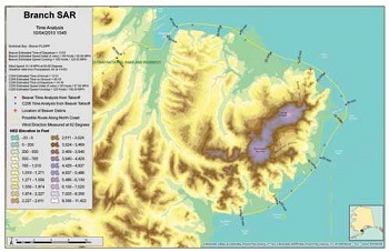
Additional distance and directional analyses were completed in the area immediately surrounding the last known location of the missing aircraft. Variables including the estimated time of departure, aircraft cruising speed, and wind speed and direction at that time were used to map possible routes the aircraft may have flown. These calculated routes were overlaid with maps of radio propagation and compared against another aircraft in the vicinity of the disappearance for possible points of overlap in radio communication.
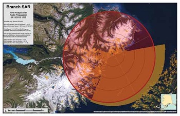
Geospatial software, hardware, and data are likely the best technology available at this time to accurately process and efficiently manage the voluminous amount of data associated with an air search of this magnitude. During the Branch SAR effort, there were up to a dozen small aircraft, three civilian helicopters, Coast Guard C-130 and Jayhawk, and National Guard C-130 and Blackhawks in the air and collecting data on any given day. These aircraft covered the rugged terrain of an area exceeding four million acres and in two weeks accumulated more than 60,000 miles of search flights. Without the geospatial tools to visualize and analyze this information, the SAR Incident Management Team could not have operated as systematically and effectively as they did. GIS was used throughout the duration of this search mission and the SAR GIS team worked diligently to support this effort by providing the planning and operations sections with up-to-date maps and analysis results so they could make the best informed decisions possible. The workflow used by the SAR GIS team, including the procedures developed to make the most out of the incoming data, were documented and developed in such a way that they can be reused or expanded upon should another emergency situation arise in the future.
References
United States Coast Guard. April 3, 2009. SAR Program Information. http://www.uscg.mil/hq/cg5/cg534/SAR_Program_Info.asp (accessed December 7, 2010).
Part of a series of articles titled Alaska Park Science - Volume 10 Issue 2: Connections to Natural and Cultural Resource Studies in Alaska’s National Parks.
Last updated: August 8, 2016
