Part of a series of articles titled Alaska Park Science - Volume 19, Issue 1 - Below the Surface: Fish and Our Changing Underwater World.
Article
Fish Inventories of the Upper Kobuk and Koyukuk River Basins

ADF&G/NATE CATHCART
The Alaska Freshwater Fish Inventory (AFFI) program was established by the Alaska Department of Fish & Game (ADF&G) in 2002. Tasked with documenting freshwater fish species assemblages throughout the state, this program is a major contributor to ADF&G’s Catalog of Waters Important for the Spawning Rearing or Migration of Anadromous Fishes or the Anadromous Waters Catalog (AWC). Alaska state law affords special protection to lakes and rivers that support anadromous fish species under the Anadromous Fish Act (Alaska Statute 16.05.871). Qualifying water bodies are recorded in the AWC. There are physical maps and an online mapping application of the AWC that specify the location and extent of water bodies that are documented by ADF&G to support anadromous fishes and are therefore protected by state law. Anadromous describes a life history strategy where fish are born in freshwater, migrate to the ocean as juveniles, then return to freshwater to spawn as adults. The most commonly acknowledged species of anadromous fish in Alaska are the five species of Pacific salmon, but there are at least 21 species of anadromous fish documented in Alaska including Dolly Varden (Salvelinus malma), Arctic lamprey (Lampetra camtschatica), and three whitefish species, including sheefish (Stenodus leucichthys). In addition to documenting the distribution of anadromous fishes, these inventory efforts also document various freshwater resident fish species including round whitefish (Prosopium cylindraceum), longnose sucker (Catostomus catostomus), northern pike (Esox lucius), and Alaska blackfish (Dallia pectoralis). Some species have variable life histories in Alaska, whereby some populations can have both freshwater resident and anadromous life histories such as Dolly Varden, rainbow trout (Oncorhynchus mykiss), and sheefish.
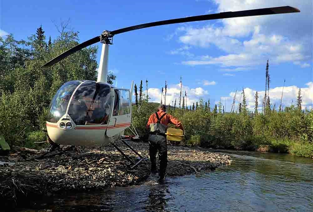
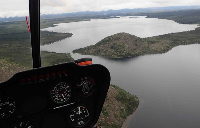
Each year, AFFI project staff identify a project area with a high concentration of water bodies with limited or no fish distribution information. Typically, staff use helicopters to access these remote areas where they conduct a rapid, systematic inventory of fish species using multiple gear types including electrofishers, minnow traps, seine nets, and hook-and-line gear. Data on aquatic and riparian habitats are also gathered at each site. Ultimately, the information collected is added to the AFFI database and streams found to support anadromous fish species are nominated to the AWC. All collected data are available through an interactive mapping application available on the ADF&G website.
In late 2017, AFFI staff were contacted by a wildlife biologist with the National Park Service (NPS) who had recently tracked GPS-collared grizzly bear (Ursus arctos) movement concentrated in stream corridors along the southern boundary of the Gates of the Arctic National Park & Preserve, one of the northernmost national parks in the United States. In several instances they documented bears feeding on chum salmon (Oncorhynchus keta) in tributaries of the upper Koyukuk and Kobuk river basins. NPS staff noted that the extents of anadromous species distribution in several of these water bodies were not accurately represented in the AWC. Together, NPS and AFFI staff designed a field survey to meet AFFI objectives and provide valuable fisheries information to the NPS by inventorying fish communities along the southern edge of the Brooks Range in the upper Koyukuk and Kobuk river basins.
Kobuk and Koyukuk River Basins
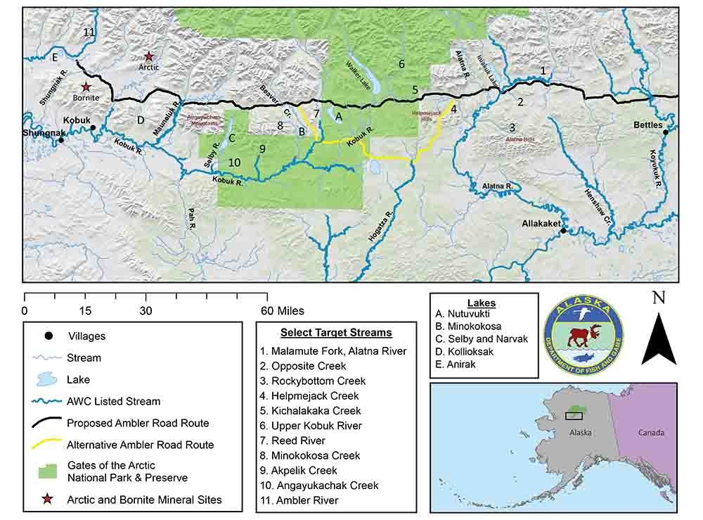
The 2018 AFFI project study area covered roughly 400 square miles (1,036 km2) of the upper Koyukuk and Kobuk river basins just north of the Arctic Circle. The landscape within the project area is made up of low, rolling mountains, interspersed with boggy lowlands underlain by permafrost, and bordered along its northern edge by the tall rugged mountains of the Brooks Range. In 1980, the United States Congress designated a portion of the upper reaches of the Koyukuk and Kobuk rivers as part of the National Wild and Scenic Rivers System. The focus of this article is on a stretch of land between the easterly village of Bettles and the western village of Kobuk (Figure 1). The water bodies across this area had not previously been systematically sampled, although some traditional information pertaining to fish distributions exists as a helpful guide (Yukon River Drainage Fisheries Association 2008).

These two river systems support important subsistence and commercial fishery harvests. The most recent ADF&G annual report published by the Division of Subsistence in 2017 (Fall et al. 2017) indicates that 101,772 salmon and 187,465 non-salmon fish were harvested within these subsistence fisheries areas in 2014. In 2017, approximately 462,000 chum salmon were harvested in the commercial fishery in Kotzebue Sound near the mouth of the Kobuk River. The Koyukuk River appears to be the largest single contributor to the summer chum salmon run on the Yukon River. The Koyukuk River drainage Chinook salmon (Oncorhynchus tshawytscha) run has been identified by ADF&G as a Stock of Concern (5 AAC 39.222) since 2000 and is an important subsistence fishery.
These lands and waters are remote, largely undeveloped, and support subsistence lifestyles; however, the area has some industrial development and is open to potential development in the future. Accurate fish distribution data are critical to the agencies that manage these lands and the stakeholders that rely on the fish resources of the region. Active and proposed developments include the Bornite and Arctic mines, respectively, in the Ambler Mining District (Figure 1). Another proposed development is the Ambler Road, a 211-mile (339 km) industrial access road starting at the Dalton Highway, south of Wiseman, and stretching west to its terminus north of Kobuk, near Lake Anirak. This longitudinal corridor is bordered by the Brooks Range to the north and a progression of foothills rising to the south. The southern boundary includes the Alatna Hills of the Koyukuk Basin, the Helpmejack Hills (a conjunctive landform between the Kobuk and Koyukuk river basins), and the Angayucham Mountains of the Kobuk River valley. In 1980, the Alaska National Interest Lands Conservation Act (ANILCA) established a right-of-way across Gates of the Arctic National Park & Preserve for the pro-posed industrial road to access the Ambler Mining District. Documenting fish distributions here will assist management agencies, local villagers, and private companies in making informed decisions about important fish communities that may be sensitive to resource development, changing land uses, or shifting climate patterns.

ADF&G/NATE CATHCART
From Bear Surveys to Fish Surveys
Within the project area, geographic information system (GIS) mapping software was used to select and rank potential sample sites. The highest rank was given to the site that would add the most mileage to the AWC if anadromous fish were documented. Additional considerations were made to ensure that sampling effort would not be too concentrated in certain drainages and to ensure that sample sites were accessible given helicopter fuel and payload limitations. Once in the field, staff navigated to selected sites using professional judgement to identify a safe landing zone proximal to selected target sites. Fortunately, AFFI staff had the additional benefit of information from the NPS wildlife biologist who provided valuable data on grizzly bear distributions that identified specific locations where salmon were likely to be spawning.
Due to the remoteness of the project areas, AFFI staff relied on two helicopters to transport two 2-person crews that primarily used electrofishing methods to sample fish. Electrofishing involves passing a current through the water to induce “taxis” where fish are briefly immobilized or involuntarily forced to swim toward the source of the electrical current. Once immobilized or attracted toward the electrical source, fish are netted, then transferred to a bucket or livewell before being identified, measured, photographed, and released following a period of recovery. There are three major benefits of electrofishing: (1) when performed correctly, the majority of fish are not harmed; (2) it is less selective than many capture methods, allowing staff to collect a broad range of species and life stages in a single effort and; (3) it is time efficient, allowing crews to visit a greater number of sites per day. On a typical day, the raft crew floated one stream, continuously sampling for several miles, while the headwater crew visited four to eight sites sampling a 500 to 1,000 feet (150 to 300 m) stream reach at each site.
Electrofishing was the primary method of fish sampling, but not the sole method. Aerial surveys were used to determine if adult salmon were present or spawning in water that was clear enough to identify species from the air. The headwater crew occasionally used hook-and-line surveys in deeper waters where electrofishing was less effective, and minnow traps to sample for juvenile salmon (and other fishes). Non-lethal tissue samples were collected for genetic testing by the ADF&G Division of Commercial Fisheries. Voucher specimens and tissue from select fish species were also collected for the University of Alaska Fairbanks Museum of the North for their collection of Alaskan fish species.
AFFI field crews also recorded baseline habitat data at each target stream and took photos of the sample reach. Habitat data included a suite of riparian and geomorphic habitat measurements as well as water quality parameters. These variables provide a qualitative and quantitative assessment of the sample locations and provide some information about the habitat quality for various fish species and life history requirements (i.e., size of stream substrates, pH, presence of large wood for cover, or water temperature).

ADF&G/NATE CATHCART
Project Outcomes
From July 24 to August 13, 2018 the two AFFI field crews spent 20 days in the field and documented 14 fish species in total across the project area, 13 of which were present in waters adjacent to the proposed road corridor. Individual fish ranged from 3-inch (76 mm) Alaska blackfish to large adult sheefish reaching 3.5 feet (914 mm) in length. Anadromous species encountered along the proposed Ambler Road corridor included Dolly Varden, chum salmon, Chinook salmon, and humpback whitefish (Coregonus pidschian). Freshwater residents were represented by Arctic grayling (Thymallus arcticus), lake trout (Salvelinus namaycush), round whitefish, burbot (Lota lota), longnose sucker, northern pike, and slimy sculpin (Cottus cognatus). The 14 species documented in 2018 by the AFFI program accounts for almost 25% of the approximately 55 Alaskan fish species that inhabit freshwater during some part of their lives (Morrow 1980). AFFI sampling efforts likely underestimated the actual diversity in the study area because staff did not encounter species previously documented such as broad whitefish (Coregonus nasus), least cisco (Coregonus sardinella), coho salmon (Oncorhynchus kisutch), and lake chub (Couesius plumbeus; Mecklenburg et al. 2002). This is likely a result of our sampling timeframe, effort, and location relative to those species’ life histories. Although sampling was scheduled when anadromous fish were expected to be present in the target water bodies, natural variation in species distributions and run timing does not exactly coincide with all sampling efforts. Another limitation of the project is work was focused primarily on streams and, in general, AFFI staff do not target fish communities in lakes. Accordingly, Iniakuk, Walker, Nutuvukti, Minokokosa, Narvak, Selby, and Kollioksak lakes will need further examination to document fish species dependent on these lake habitats.
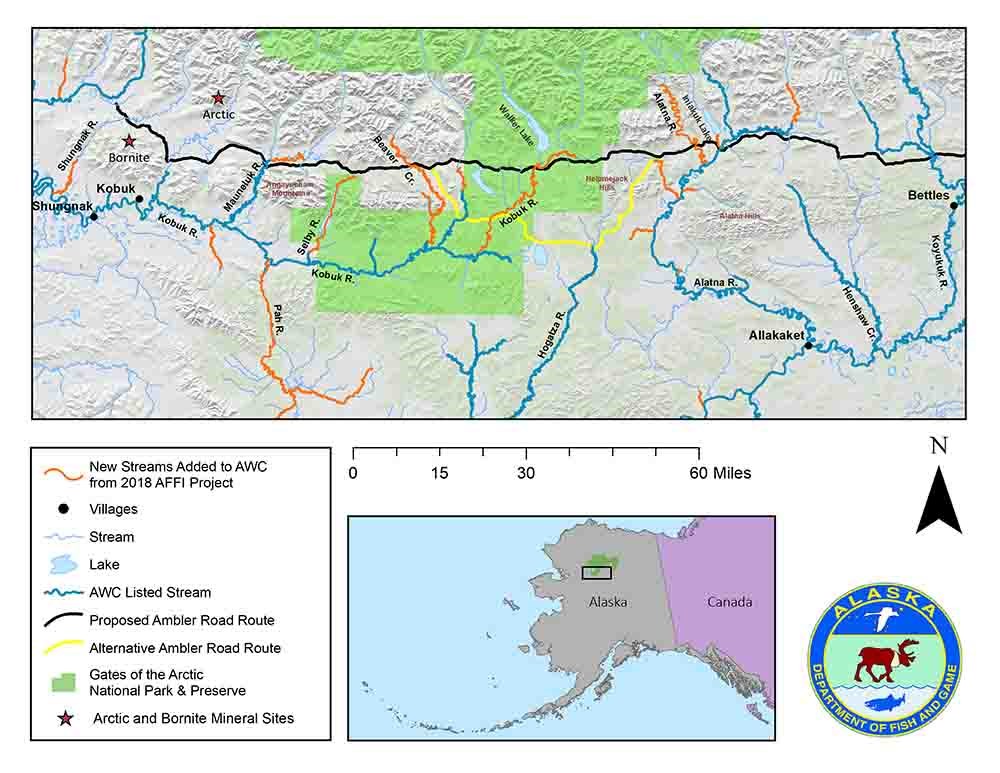
This field work culminated in adding or extending 41 streams to the AWC, totaling 481.4 miles (774.7 km) of newly documented anadromous fish habitats. In the proposed road corridor, 12 AWC streams were added or extended that would be crossed by the proposed Ambler Road (Figure 2), along with resident fishes documented throughout. Observations of spawning adult and rearing juvenile Chinook salmon were limited to the upper Koyukuk River basin including Helpmejack Creek and the Malamute Fork Alatna River and its tributaries. Chum salmon were present throughout this corridor including the Alatna River and its tributaries (Rockybottom and Helpmejack creeks) in the Koyukuk River drainage; they were also in the upper Kobuk River, Reed River, Beaver Creek, Mauneluk River, Shungnak River, and a tributary to the Ambler River (i.e., the end of the proposed road) from the Kobuk River drainage. Other creeks peripheral to the corridor that supported chum salmon and Dolly Varden included Akpelik Creek and the Selby River downstream of Angayukachak Creek. Dolly Varden were also found far upstream in the easternmost site of the Kobuk River drainage, Kichalakaka Creek, and upstream of Minokokosa Lake. Interestingly, a single humpback whitefish was captured at the outlet of Walker Lake; this is an anadromous whitefish species with no prior documented presence in the Kobuk drainage raising further questions about their distribution and abundance in Alaska.

Post-field season, AFFI staff contacted village residents and biologists familiar with the area. This was done in an attempt to locate supplemental information that would corroborate AFFI sampling results in locations where the sampling efforts did not capture species that were anticipated or only in limited numbers. For example, searches for additional documentation of species in lakes of the upper Koyukuk River drainage led to information on (and pictures of) the presence of least cisco in Iniakuk Lake as well as evidence of chum salmon spawning in the lake’s tributaries—observations project staff did not experience. Information such as this can be used to guide additional sampling efforts.

ADF&G/JOE GIEFER (left), NATE CATHCART (center), KATELYN ZONNEVILLE (right).
Summary
The 2018 AFFI season in the Brooks Range added hundreds of new miles to the AWC and improved overall knowledge of fish species assemblage, distribution, and abundance in this region. The information gathered by this study will be useful for stakeholders of this region and can guide management actions and future studies of aquatic resources.
The two crews had extraordinarily nice weather for the three weeks of field work that equated to about 20 minutes spent in rain gear. This not only kept morale high and flying safe, but also allowed for more effective sampling on the water and in the air since our vision was not impeded by rippled water. Indeed, aerial surveys identifying spawning chum salmon provided the bulk of miles added to the AWC by the headwater crew. Proposed future work seeks to build off this success by performing more aerial surveys later in the year when chum salmon (and potentially coho salmon) would be more likely to have reached their spawning locations. Unfortunately, the wonderful run of good weather should not be considered typical.
All AFFI data are publicly accessible and stakeholders are encouraged to use the online tools provided by the ADF&G. To visualize the AWC and explore AFFI sampling events, the annually updated Fish Resource Monitor Internet Map Service can be accessed from the ADF&G website or found in our references. Users can view species distributions, note sampled locations and unsampled streams, dive deeper into site-specific data (including pictures), and download a form to nominate water bodies for inclusion in the AWC.
Acknowledgments
We are extremely grateful for the conceptual, logistical, and material support from Mat Sorum (NPS), the assistance of helicopter pilots Luke Fledderman (Coastal Helicopters) and Eryk de la Montana (Quicksilver Air), and the field crews (as well as the cooking skills) of Josh Brekken, Maxwell Newton, Lisa Stuby, and Katelyn Zonneville. Duncan Green and Guy Moyer provided essential gear and personnel logistics in Bettles and Kobuk, respectively. Judy Jesperson and Brooks Range Aviation were instrumental in moving our base camp from Bettles to Dahl Creek. We appreciate permitting from the BLM (April Rabuck and Robin Walthour) and US Fish and Wildlife Service (Tina Moran and Bob Rebarchik). Any use of trade names does not imply endorsement.
This project has been funded wholly or in part by the United States Environmental Protection Agency under assistance agreement 83590301 to the US Endowment for Forestry and Communities. The contents of this document do not necessarily reflect the views and policies of the Environmental Protection Agency, nor does the EPA endorse trade names or recommend the use of commercial products mentioned in this document. The US Endowment for Forestry and Communities, Inc. is a not-for-profit corporation that works collaboratively with partners in the public and private sectors to advance systemic, transformative and sustainable change for the health and vitality of the nation’s working forest and forest-reliant communities. Additional funding for this project was provided by the Alaska Sustainable Salmon Fund (AKSSF), a State Wildlife Grant (SWG), and State Fish and Game funds.
References
Alaska Department of Fish and Game, Division of Sport Fish. 2018.
Alaska Freshwater Fish Inventory. Available at: http://www.adfg.alaska.gov/index.cfm?adfg=ffinventory.main (accessed November 7, 2018)
Alaska Department of Fish and Game, Division of Sport Fish. 2018.
Fish Resource Monitor Interactive Mapper. https://adfg.maps.arcgis.com/apps/webappviewer/index.html?id=f5aac9a8e4bb4bf49dc39db33f950bbd (accessed November 7, 2018)
Fall, J. A., A. Godduhn, L. Hutchinson-Scarsbrough, B. Jones, M. Kukkonen, L. A. Sill, A. Trainor, and T. Lemons. 2017.
Alaska subsistence and personal use salmon fisheries 2014 annual report. Alaska Department of Fish and Game Division of Subsistence, Technical Paper No. 427, Anchorage.
Mecklenburg, C. W., T. A. Mecklenburg, and L. K. Thorsteinson. 2002.
Fishes of Alaska. American Fisheries Society. Bethesda, MD.
Morrow, J. E. 1980.
The freshwater fishes of Alaska. Alaska Northwest Publishing Company, Anchorage, AK.
Yukon River Drainage Fisheries Association. 2008.
Middle Koyukuk River of Alaska: An atlas of fishing places and traditional place names. National Oceanic and Atmospheric Administration. Anchorage, AK.
Last updated: May 29, 2020
