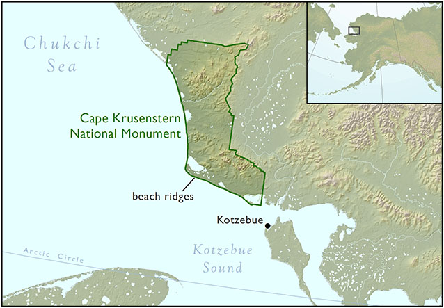
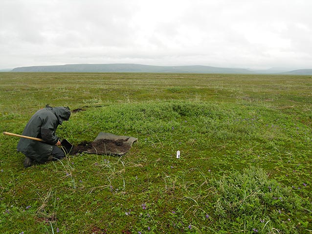
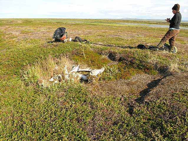
Archaeologists cruised the low-lying, undulating topography of Cape Krusenstern on Kotzebue Sound’s north shore (Figure 1). They were looking for remnants of the past; anything that indicated that someone, sometime, stopped here to sharpen a stone tool, build a fire, or even spend a season. From both published descriptions and previous experience, the crew knew what to look for: glimpses under the sparse tundra vegetation of fire-reddened rocks, angular pieces of broken chert, or subtle variations in vegetation in the gravel ridge tops (Figure 2). At complex archaeological sites, such as the beach ridges of Cape Krusenstern, there are often multiple pasts to discover. People of several different cultures have lived here for more than 4,000 years. In some cases, a more recent past must also be taken into account. In this case, archaeologists were excited when they found items like rusty sardine cans, wooden barrel staves, and a broken shovel handle. These items were clues to previous archaeological research that occurred here in the 1950s and ‘60s (Figure 3). These clues, in turn, helped the archaeology crew from the University of Washington integrate recent finds with existing documentation. With a better understanding of how new archaeological data overlapped with, and differed from, existing documentation, researchers are able to evaluate new models and interpretations more critically.
NPS Photo / Adam Freeburg
NPS Photo / Adam Freeburg
From 2007 to 2012, researchers from the University of Washington, in a collaborative project with the National Park Service’s Western Arctic Parklands, conducted field and laboratory research to identify patterns of dynamic human and environmental interactions within the beach ridge complex of Cape Krusenstern National Monument. To our great benefit, the pioneering work of J. Louis Giddings and Douglas D. Anderson provided a strong framework on which to base renewed archaeological questioning and further archaeological inquiry of Northwest Alaska. To make the most of this existing work, a great deal of time was spent incorporating these “legacy data” into our methods. As described by Anderson and others (2009), information from published sources as well as original field and laboratory documentation was recorded and integrated into the project GIS, where the data were used to inform survey areas, sampling locations, analyses, and interpretations. These legacy spatial locations, and their accompanying annotations and feature information, form the basis of the analyses and comparisons that are part of the continuing outcomes of this project.
Overall Legacy Results
A complete legacy database of 688 features was ultimately compiled. This is considered a conservative estimate for the total number of features that Giddings’ team noted in their investigation at the beach ridge complex in the 1950s and ‘60s, but represents the most complete list possible from available sources. Without some idea of spatial location, information about a feature is of little value. In all, over 600 features could at least be attributed to a particular beach ridge or segment. The vast majority of these features could be attributed to annotated points on a digitized and georeferenced photomosaic (see Anderson et al. 2009). There is not a one-to-one ratio of features to points, since some point locations represent multiple features. By loading these locations onto GPS units, field crews were able to anticipate and investigate the approximate locations of features recorded by Giddings. A large number of features were relocated and determined to be Giddings’ features with a relatively high degree of confidence (Figure 4). In some cases, several features were located near the reported location of the legacy feature, so no definitive results could be determined. At other legacy feature locations, there was simply nothing found.
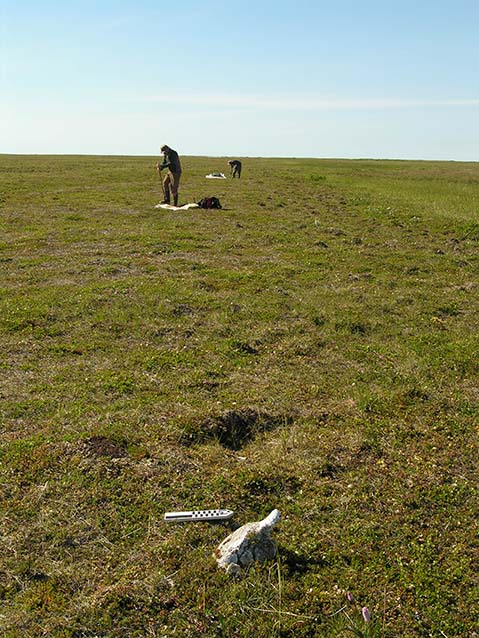
Photo courtesy of Liz Penttila
New Impressions of Old Sites, Denbigh Hearths
At Cape Krusenstern, the beach ridges have built up gradually over time, starting as a series of gravel spits extending from the east. The earliest people to occupy these nascent beach ridges were people that used a specific stone tool technology, which in Alaska is known as the Denbigh Flint culture. Originally discovered on Norton Sound (Giddings 1967), this technology was used by people who are recognized as the first to routinely inhabit northern Alaska coastlines. The Denbigh Flint culture is ascribed to the larger Arctic Small Tool tradition, bearers of which continued from Alaska across the Arctic to Canada and Greenland.
No known remains of Denbigh structures have been found at Cape Krusenstern. Instead, the most common indicators of human presence are hearths of campfires, often built with flat stones that contrast with the rounded pea-sized gravels that make up the beach ridges. Giddings and Anderson (1986) interpreted these hearths to be the remains of late-spring or early summer campsites, when Denbigh people would pitch tents of animal skin on the coast and hunt seals. Because these were temporary camps, the resulting archaeological material and features can be difficult to distinguish. Luckily, both the flat stones and the beach gravels are often oxidized from the fire, resulting in a reddish hue that can be noticed between the sparse tundra vegetation (Figure 5). Stone tools, such as microblades, microblade cores, and burins, are sometimes found with the hearths (Figure 6). Hearths were often reported by Giddings and Anderson (1986) as occurring in linear series along a beach ridge. It is unknown if the close proximity of multiple hearths implies contemporaneity, but it is generally assumed that the number of features resulted from a small number of people returning to the beach ridge complex over the course of multiple years.
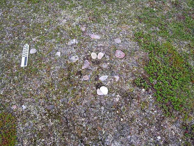
Photo courtesy of Fawn Carter
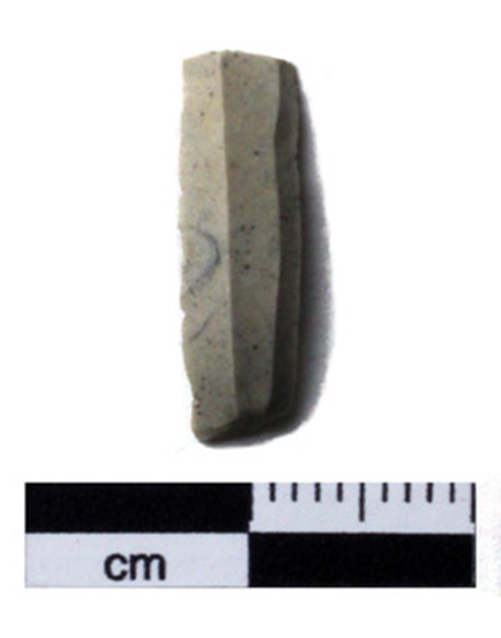
Photo courtesy of Shelby Anderson
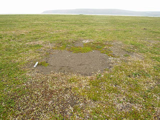
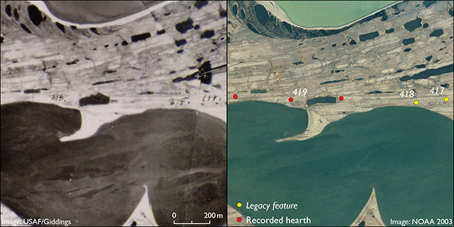
Legacy feature 419 was one hearth attributed to the Denbigh culture that fell within the survey area investigated by the University of Washington team. This feature serves as an excellent example of the accuracy with which the legacy features were often able to be placed on the photomosaic by Giddings. Within two meters of the derived feature location shown by the photomosaic in GIS, we found a deflated surface lacking vegetation, but containing a concentration of rocks cracked and reddened by fire (Figure 7, Figure 8). Therefore, we confirmed legacy feature 419 to be a previously excavated hearth. Though excavated, a thorough surface search was conducted in and around the area to determine if any artifacts were present, but nothing further was found. Two other hearths (legacy features 417 and 418) were nearby according to Giddings’ photomosaic, but their locations fell outside of the new project’s survey area, so relocation was not attempted (see Figure 8).
NPS Photo / Adam Freeburg
Three additional hearths were recorded by the University of Washington team in the central beach ridge complex, including another known site recorded in the 1980s. In this location, features are generally assigned to the Denbigh culture. None of these hearths appeared to have been previously excavated. Charcoal was found and collected from two of the hearths. An additional charcoal sample associated with a biface fragment was found eroding out of a nearby lakeshore cutbank. Both artifacts were collected, and the charcoal was submitted for dating along with charcoal from the hearths. The dates of each sample falls well within the Denbigh culture period. These are the first absolute dates on Denbigh-period materials from Cape Krusenstern (Table 1).
Table 1. Denbigh feature radiocarbon (RC) dating results.
| Catalog Number | Material | Description | RC Age | Calibrated Date |
|---|---|---|---|---|
| CAKR 13580 | Charcoal | Picea | 3760 ± 35 | 2289 BC - 2041 BC |
| CAKR 14011 | Charcoal | Salicacea, cf. Salix | 3620 ± 30 | 2119 BC - 1893 BC |
| CAKR 13389 | Charcoal | Picea | 3450 ± 30 | 1880 BC - 1688 BC |
A Refined Chronological Model
Throughout the project, the scenario described above for locating and confirming legacy features was carried out simultaneously with systematic pedestrian survey and testing. Ultimately, this work not only contributed data for our overall results and interpretations, but also provided a closer look at the data behind past interpretations of the beach ridge complex. The broad strokes of culture history and occupation still stand as determined by Giddings and Anderson (1986), a testament to their pioneering work. Their intra-site interpretations, made possible due to their methods of full-feature excavation and recovery of diagnostic materials, remain the definitive work for the beach complex. We have been able to refine the existing chronological model and provide new detail, however, due to our systematic, intensive survey with a focus on recovery of dateable materials, as well as our use of high-resolution GPS data collection.
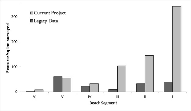
Giddings’ (1966) innovative use of prograding shorelines, such as Cape Krusenstern, as a horizontal stratigraphy was based on the tenet that people would always choose to camp closest to the sea. Mapping and dating of over 2,000 features and artifacts across the beach ridge complex shows use of the entire landscape, with people using all the beaches that existed in their time for a variety of purposes and activities (see Anderson and Freeburg 2013), though Giddings’ tenet generally holds for settlements. In addition to the horizontal stratigraphy provided by individual ridges, different depositional and erosional sequences have formed geomorphologically distinct groups of beach ridges that Giddings termed “segments.” These segments are useful analytical units with which to compare new and old data, and are identified by roman numerals (“I” for the youngest, closest to the active beach and “VI” for the oldest, closest to the lagoon). A comparison of legacy features and newly recorded features found within the University of Washington’s survey area shows marked differences in archaeological feature density (Figure 9). We interpret this to be due to the research methods of the current project, which included systematic survey with tightly spaced transects. While the previous survey work resulting in the legacy data was extensive across the site complex, it was not as systematic or intensive as the recent work. So, while these results support the overall patterns established by Giddings and Anderson (1986), they also indicate much higher population estimates for the site complex (see Anderson and Freeburg 2014). They also indicate a more intensive use of the beaches starting about 2,500 years ago, with an increasing trend. How this changes local and regional archaeological interpretations is the subject of continuing study by the project team.
Conclusions
With such a large geographic extent to cover, archaeologists in Alaska are often covering new ground. Increasingly, however, archaeologists are returning to previously researched sites. At Cape Krusenstern, the work done by Giddings and Anderson provided not only an excellent foundation for renewed archaeological investigation, but also insightful points of comparison in both methods and results. These comparisons highlight the usefulness of legacy data, as well the importance of continued archaeological study, allowing researchers to bring new ideas, new methods, and new perspectives to established ideas of the past.
References
Anderson, S. L. and A. K. Freeburg. 2014.
High latitude coastal settlement patterns: Cape Krusenstern, Alaska. The Journal of Island and Coastal Archaeology 9(3):295-318.
Anderson, S. L. and A. K. Freeburg. 2013.
A high-resolution chronology for the Cape Krusenstern Site Complex, northwest Alaska. Arctic Anthropology 50(1):49-71.
Anderson, S., A. Freeburg, and B. Fitzhugh. 2009.
Cultural vulnerability and resilience in the Arctic: preliminary report on archaeological fieldwork at Cape Krusenstern, northwest Alaska. Alaska Park Science 8(2):42-45.
Giddings, J. L. 1966.
Cross-dating the archaeology of northwestern Alaska. Science 153(3732):127-135.
Giddings, J. L. 1967.
The Archaeology of Cape Denbigh. Brown University Press. Providence, RI.
Giddings, J. L. and D. D. Anderson. 1986.
Beach ridge archaeology of Cape Krusenstern: Eskimo and pre-Eskimo settlements around Kotzebue Sound, Alaska. Publications in Archaeology 20. National Park Service. Washington, D.C.
National Oceanic and Atmospheric Administration (NOAA). 2003.
High-resolution orthorectified imagery for the coastal areas of Bering Land Bridge National Preserve and Cape Krusenstern National Monument. Collaborators: National Park Service Arctic Network Inventory and Monitoring Program, University of Colorado Institute of Arctic and Alpine Research, AeroMap US, Aero-Metric Inc., NOAA National Geodetic Survey.
United States Air Force (USAF).
U.S. Air Force aerial photographs of northwest Alaska. Scale 1:43,000. Acquired 1949-1956. Ink annotations by J. L. Giddings.
Part of a series of articles titled Alaska Park Science - Volume 16 Issue: Science in Alaska's Arctic Parks.
Last updated: March 6, 2017
