Article

World War II Aleut Relocation Camps in Southeast Alaska - Chapter 7: Ward Lake CCC Camp
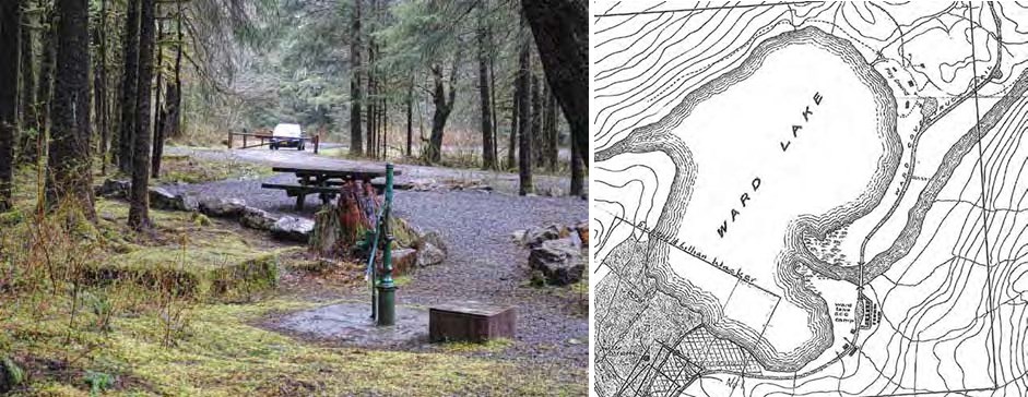
Composite image: left: forested picnic area with car in background. Right: line drawing map of Ward Lake area
Figures 202 and 204. Left: The Ward Lake CCC camp is now the site of a USFS picnic area, here viewed to the southwest. Right: A 1935 map of Ward Lake shows the road crossing the Wacker homestead, passing between the CCC shop and garage, then immediately entering the residential area of the camp.

Right: Ketchikan Museum

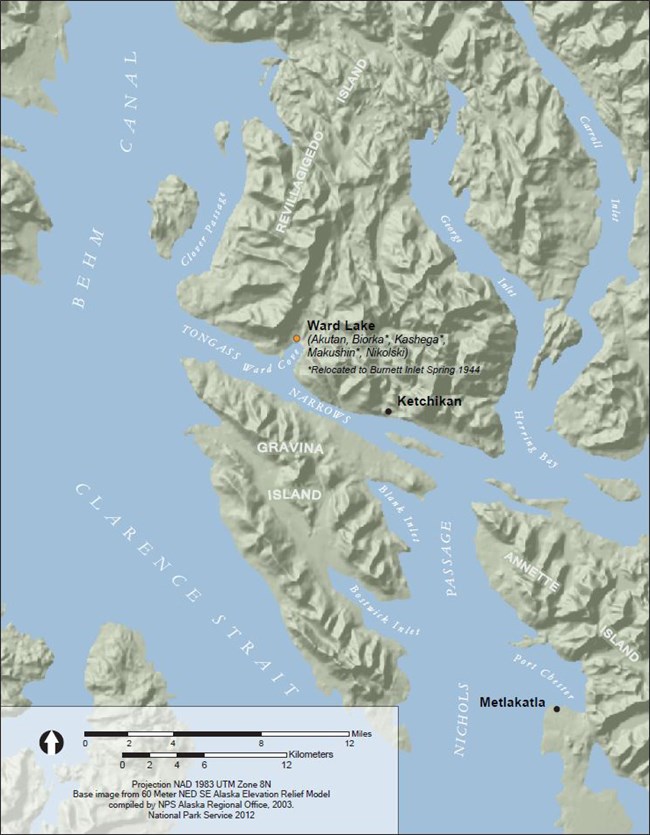
The Ward Lake CCC camp – a federal work camp north of Ketchikan – became the wartime home for Aleuts from Akutan, Biorka, Kashega, Makushin, and Nikolski. Ketchikan is the southernmost town in southeast Alaska, in the heart of Alaska’s temperate rain forest. The average annual rainfall of 236 inches grows huge spruce, hemlock, and red and yellow cedar trees (U.S. Department of Commerce 1978:54), creating a deeply shaded understory (Figure 202). Ten miles northwest of Ketchikan along the shore of Revillagigedo Island is Ward Cove, fed by Ward Creek, which drains Ward Lake (Figure 203). Near the southeast shore of the lake, at the base of a mountain where the sun rarely shines, is the Ward Lake CCC camp (Figure 204).
Map showing islands and waterways including Clarence Straight, Gravina Island, and locations of Ward Lake and Ketchikan
Figure 203. Villagers from Akutan, Biorka, Kashega, Makushin, and Nikolski were interned at a CCC camp at Ward Lake, ten miles northwest of Ketchikan by road. Some men subsequently found employment at a military airfield under construction near the Tsimshian village of Metlakatla, on Annette Island.

Early Years

Ward Cove saw commercial activity as early as 1883-84 with the establishment of a saltery (Orth 1967:1028). Then, in 1912 – the same year the Burnett Inlet cannery was built, a cannery was built at Ward Cove (MacDonald 1949:33). In the late 1910s Eugene Wacker claimed a homestead between Ward Cove and Ward Lake, and his 160 acres became known as Wacker – later absorbed by the community of Ward Cove (Orth 1967:1028). In 1924 a coastal road known as the Tongass Highway was completed between Ketchikan and Ward Cove, and in that year Eugene Wacker began a commercial bus service between the two points (Ostlund 1980). This coincided with new federal policies supporting recreational use of public forests. Responding to the Ketchikan Women’s Club’s two new picnic areas built near the mouth of Ward Creek in 1925, and a Territorial Fisheries Department’s trail cut that same year, USFS during the following two years extended the trail around the lake and stationed two rowboats for public use (Ketchikan Museum 2008).

Composite of two black and white images. Left: aerial view of people gathered on a forested shore. Right. Dirt road with two garages and trees.
Figures 205-206. Left: The Ward Lake picnic area was a popular destination in the late 1930s. Right: Just before reaching the CCC camp the Ward Lake Road traveled between the CCC shop (left) and garage (right), here looking northeast in 1936.

Left: Ketchikan Museum 99.2.1.4. Right: Ketchikan Museum

A decade later, public recreational facilities (Figure 205), workshops (Figure 206), and a residential camp were built at Ward Lake by the Civilian Conservation Corps (CCC) through the U.S. Forest Service (Rakestraw 1981:95-108). The CCC was created in 1933 under Franklin D. Roosevelt’s administration “to furnish employment, vocational training and educational opportunities for unemployed youth, to enable young men enrolled in the CCC to provide aid for their dependent families, and to advance a nationwide conservation program on forest, park, and farm lands” (Federal Security Agency 1940:1). By 1937 the CCC had over 1,000 men working in southeast Alaska to address “practically every human need in the territory, including airstrips, housing, fire and flood control, demolition, communications, sanitation, wells, cabins, trails, roads, bridges, shooting ranges, fences, floats and docks, dams, hatcheries, totem pole restoration, and archaeology” (Mobley 1992:4).
Blueprint with white lines and some yellow areas. Text reads "Ward Lake Camp Scale 1" = 20'"
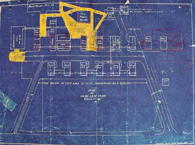
Figure 207. A 1935 blueprint of the CCC camp, filed with USFS in Ketchikan, conforms to the layout in archival photographs. The red overdrawing shows proposed building orientations that were not built; the meaning of the yellow overlay is unknown.

Ketchikan Museum U.S. Forest Service collection

Six small bunkhouses were completed at Ward Lake in 1935, soon followed by more buildings, creating a self-contained camp with the capacity for 65 men (Ketchikan Museum 2008). The bunkhouses were narrow cabins measuring 10’ x 20’, set on low piling foundations, with shallow rounded roofs. The standardized design was also used for other functions: a foreman’s cabin, cook’s storeroom, washroom, and laundry (Figure 207). The modular design allowed construction of a generator shed half the size of the cabins (Figure 208). One of the buildings was used as a kitchen, with two more appended at a right angle as mess halls.The identical buildings were aligned 20’ apart in two rows with their gable ends facing each other across a 20’ wide street. Other buildings on the plan include a large recreation hall, a large bunkhouse (18 ’x 52’), coal shed, bake shop, meat house, cook’s room, and toilet. These were frame buildings with gable roofs; archival photographs show some sheathed with board-and batten siding (Figure 209).

Composite of two black and white photos. Left: small white building. Right: cluster of small wooden buildings.
Figures 208-209. Left: The CCC camp had its own electrical system powered by a diesel generator housed in a cabin modified with vents and an exhaust stack. Right: The CCC cabins at Ward Lake consisted of more than a dozen simple arched-roof buildings in two parallel rows, among several larger gable-roofed buildings. At left is the recreation hall; behind it is the gable roof of the large bunkhouse, and right of center is the dry room (with smoke from chimney).

Left: Ketchikan Museum. Right: Ketchikan Museum U.S. Forest Service collection
Black and white photo of men standing between rows of identical small houses.
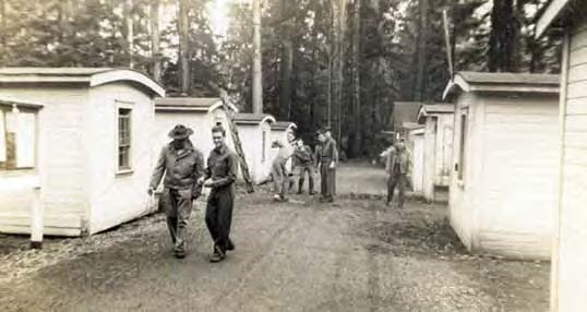
Figure 210. Soldiers with the U.S. Army Air Corps Marine Rescue Squadron clown behind their officer’s back upon completion of semaphore training at the Ward Lake CCC camp in June, 1942. The gable-roofed recreation hall can be seen at the end of the right row in this view north.

Ketchikan Museum 99.2.15.18

Over the winter of 1940-41 and into the summer of 1941 the Ward Lake camp “served as one of the staging areas for the CCC and engineer troops, their one hundred trucks, five thousand tons of cargo, and one hundred prefabricated houses bound for Annette Island,” where a large airfield was being built as part of a chain of military aviation bases along the Pacific Coast (Sorensen 1995:239). For a short time during the winter of 1941-42 the CCC camp was unoccupied, then in late spring it was rehabilitated for housing and training the first class of “crash-boat” crews (Figure 210), the units deployed along Alaska’s coasts to rescue downed airmen (Bartholomew 1995:131). By Congressional decree the CCC ceased to exist in the autumn of 1942, and the U.S. Forest Service turned over all their equipment and supplies to the U.S. Army (Gruening 1942:5). The Army unit then vacated the Ward Lake CCC camp.

World War II and the Camp Experience

Bartholomew (1995:131) says his arriving military unit cleaned up the CCC camp buildings, which had been vacant less than a year, and lived in them until ordered to vacate so Aleut evacuees could move in. At that time the original 15-building CCC camp was intact, and in a photograph labeled June of 1942 all visible buildings are in their original locations (Figure 210). Villagers testifying in 1981 mentioned nine small cabins and three large buildings, approximating the original camp configuration. A timeline prepared by the Ketchikan Museum (2008) states that the CCC camp was closed in April of 1942, conflicting with the June date attributed to Figure 210, but either way the archival record suggests that the facility was intact and functional when it was turned over to the evacuees.

But when the 163 Aleut evacuees arrived at Ward Lake they found a compound designed for a group less than half their number. Kohlhoff (1995:103-104) says the “abandoned…camp consisted of a mess hall, a ‘toilet lavatory and urinal building,…two bunk houses and two cabins,’”in which “Aleuts had ‘to sleep…on the floor in their bedrolls and blankets’” or “had to stay in tents brought from Wrangell.” Construction began immediately on 16 new cabins using lumber shipped from Wrangell to Ketchikan on the same barge with the evacuees (Figure 211). Some of the new buildings were aligned to create a row parallel to the original cabins (Figure 212). These were probably located just west of the original cabins where, in 1935, planners had directed that “the brush in this area is to be preserved as a screen” (Figure 207). None of the cabins had running water, and one large privy served the entire community (Kohlhoff 1995:105, 109).

Composite image of two black and white photos. Left: children with wheelbarrow. Right:  Children in front of a Ward Lake Evacuation Camp sign
Figures 211-212. Left: Unlike the prefabricated CCC buildings with their arched roofs, cabins built by the villagers had shallow-pitched roofs and unstandardized door, window, and porch arrangements. Mike and George Bezezekoff (left and center) and other boys pose with a wheelbarrow of canned food. Right: Children (left to right: Mike Bezezekoff, Olga Tcheripanoff, George Bezezekoff, and Angela Chercasen) pose with a sign announcing the Aleut camp at Ward Lake.

Left: Alaska State Library Butler/Dale collection PCA 306-1047. Right:  Alaska State Library Butler/Dale collection PCA 306-1044.

Black and white photo of 11 people from baby to adult standing in front of a bus.
Figure 213. Eugene Wacker had a commercial bus service that took villagers to Ketchikan and back. Left to right, according to photographer Faye Schlais, are Hugh McGlashan, Annie McGlashan, Matrona (Mattie), Agnes, Vera, Axel Jr., Eugene Wacker, Mattie, Helen McGlashan, Freddie, and Steve McGlashan.

Aleutian Pribilof Islands Association Faye Schlais collection.

The experience of the Ward Lake evacuees differed from that of the others because their camp was in easy reach of a major coastal town. With a long history as Alaska’s southernmost port of entry and a major Coast Guard base automatically under Navy jurisdiction during wartime (Mobley 1995), Ketchikan was a bustling maritime community during World War II. Kohlhoff (1995:105) asserts that “no regular transportation into the city was available to the Aleuts,” but Eugene Wacker had long provided commercial bus service from Ward Cove to Ketchikan (Figure 213), and thus the new arrivals had access to employment, merchandise, and entertainment to be found in the larger town. Day jobs could be had – something almost impossible to get at other relocation camps, and some men got construction work on the new military airbase being built at Metlakatla (Figure 203). Nonetheless, medical services were difficult to access, sanitation was poor, and disease was prevalent (Kohlhoff 1995:105). The Ketchikan community was disappointed that their favorite swimming lake was being polluted, and some citizens were vocal in their unfavorable opinions about the displaced Aleut communities camped at the end of the road. Meanwhile the unhealthy circumstances and poor medical care contributed to a high mortality rate for the camp’s residents. To help alleviate the overcrowding approximately 46 residents from Biorka, Kashega, and Makushin were moved to the Unalaska camp at Burnett Inlet in the late spring of 1944 (Kohlhoff 1995:130).

By war’s end both the Aleuts at Ward Cove and their host community welcomed the villagers’ departure as a sign of returning normalcy. When the Ketchikan Alaska Chronicle for April 17, 1945, reported on page 6 that “Aleuts Return to Aleutians,” the USAT David W. Branch had already boarded the Ward Lake villagers and left port for Burnett Inlet and Killisnoo to pick up the communities of Unalaska and Atka. The newspaper went on to announce that the camp’s removal was to begin the following day.

Post-War Development

Even before the Aleuts left Ward Lake USFS was arranging for Tlingit villagers from Saxman, just south of Ketchikan, to haul the materials away for their use. “Many of the structures will be removed intact,” said the newspaper account. A USFS agent immediately took responsibility for the camp, and it went back into USFS management after the war. Shortly thereafter the CCC camp was “leveled” and covered with crushed rock, and the last remaining buildings were sold in 1953 (Ketchikan Museum 2008). In the 1950s the USFS redeveloped the site and renamed it Three Cs Campground (Stanford 2006:23). Plans have been filed to again redesign the Three Cs Campground (Stanford 2007), but as of 2011 no redevelopment had begun.

Current Condition

The Ward Lake CCC camp was investigated May 4, 2011 – almost three years later than the other five camp sites. The team of Charles Mobley and Rachel Mason spent several rainy hours at the site, walking and photographing features with the aid of maps from two USFS cultural resource reports (Stanford 2006, 2007). A few historic features are discernible among the gravel-fill driveways and parking areas, picnic tables, pavillions, and well (Figure 202). These include two concrete pedestals, a large cobble and boulder pad bordering the small nearby creek, and remnants of a wood plank bridge, boardwalk, and stairs leading up the creek. Bark-stripped trees indicating traditional Native forest exploitation were also noted. A quick visit to the nearby site of the old CCC garage and shop (Figure 206) indicated that it contained more archaeological features than the camp location.

Line drawn map of orange site markers over black building locations.
Figure 214. Proposed improvements to the Three Cs Campground by the U.S. Forest Service prompted Stanford (2007:5) to superimpose a schematic of the existing public facilities over the old CCC camp building locations. This version of the CCC camp plan has incorrect stream placement.

The field investigation at Ward Lake documented the absence of CCC buildings, leaving a landscape vaguely correlated with the camp’s building arrangement. Stanford (2007) superimposed the existing campground improvements over an undated archival plan of the CCC camp (Figure 214). It provides a useful visualization, although the creek doesn’t bend around the south side of the camp as drawn (see Figure 204 for correct placement), and the building arrangements don’t exactly match the archival photographs (the 1935 plan – Figure 207 – is more accurate). The drive that ran between the two rows of CCC cabins and connected at either end with the road has been kept as the primary access for the campground (Figure 215).

Composite of two moder photos. Left: wide flat road among trees. Right: Car on road with concrete shape in swampy area.
Figures 215-216. The main drive through Three Cs Campground, here looking north, is the same alignment as that separating the two rows of original CCC cabins. Just south of the south entrance to the Three Cs Campground is a concrete pedestal (right) where the CCC camp’s generator house stood.

The south entrance to the contemporary campground matches that of the original CCC camp, and a concrete pedestal just south of the gate overlies perfectly the Generator House plotted in 1935 (Figure 207). The pedestal measures 4’x8’x4’ high; no bolts or bolt holes were noticed and vegetation obscured much of the feature’s surface (Figure 216). A second concrete pedestal is located near the campground’s water pump, about 150’ from the first (Figure 202). This is where the original camp privy was once located (Figure 207). The second pedestal pedestal is located near the campground’s water pump, about 150’ from the first (Figure 202). This is where the original camp privy was once located (Figure 207). The second pedestal measures approximately 4’ square and is about 20” above the present ground surface. Stanford (2006:25) reported the first pedestal as measuring 6’x3’x3’ and correlated it with the CCC camp’s generator shack; he reported the second pedestal as about two and one-half feet square (Stanford 2007:8).

Broken moss-covered wooden bridge and stream.
Figure 217. Immediately east of the camp site is a small creek spanned by a broken plank bridge.

Bounding the camp on the northeast is a small stream just losing its gradient to shortly enter Ward Creek (Figure 204). A broken wood plank bridge (Figure 217) crosses the small creek and connects with a dilapidated boardwalk (Figure 218) and steps leading upstream. The bridge is 14’ long and made of 2”x12”-4’ planks nailed to two 3”x12” stringers. Stanford (2007:8) cites Autrey (1990) and says “according to Forest Service Recreation employees this foot bridge is part of the old trail head for the Perseverance Trail which was relocated about 100 meters to the south back in 1990.” That doesn’t address the features’ age or whether they date to the CCC camp, but the trail up the creek likely leads to a concrete dam which USFS archaeologists have recorded as part of the CCC camp (the first-described concrete pedestal is included with the garage, shop, and dam as KET-072, while the second pedestal and the remainder of the CCC camp and the recreational beach area to the north are part of KET-087 (Stanford 2006:25-26, 2007:14).

The dam wasn’t part of the 2011 field investigation, and it’s purpose isn’t clear. Stanford (2006:25) doesn’t report a flume or pipe but states a burned building at the dam site may have been a pumphouse. Was the dam built to provide the camp with domestic water or hydroelectric power, or both? If so, where was the powerhouse? The limited archival and field research did not address that question, but it did turn up a building that could have been a powerhouse.

Composite of four images. Top: Mossy forest with ruins. Bottom: Line drawn maps of camp features.
Figures 218-221. Top: The bridge leads to a rotten moss-covered boardwalk. Immediately east of the camp, across a small stream, is a rock platform. Bottom: Diagram of rock feature. Location of concrete pedestals around Ward Camp.

Bounding the small stream across from the camp site is a substantial boulder and cobble platform (Figures 219-221). Stanford (2007:8) described the feature as “two series of stacked rock walls...probably built to help channel the creek perhaps to prevent erosion,” and suggested they dated to the CCC camp due to the amount of plant growth. The portion of the feature along the creek is higher than the remainder, forming a rock wall (Figure 220). The feature’s shape and size (35’x20’ with a rectangular indentation on one side) indicates a building foundation, while its location immediately adjacent to a creek with a dam upstream brings to mind the possibility that it could have handled water from that dam. Conjecture, to be sure. Neither the 1935 map (Figure 204) nor the 1935 plan (Figure 207) show a building in that location, but the ridge of a gabled building in that vicinity does appear in an undated archival photograph (Figure 209). Another undated archival photograph apparently shows the building that once stood in that location, with horizontal and vertical pipes at one corner (Figure 222). A conservative interpretation is that the rock platform represents the foundation of a utility building constructed at the CCC camp after 1935.

Black and white photo of a small house.
Figure 222. An undated archival photograph shows a building where now only a rock platform is to be found. Note pipes at the building’s back left corner, and arced-roof cabins at right.

Ketchikan Museum 1680

Several culturally modified trees (CMTs) were noted at the Ward Lake CCC camp. CMTs are trees containing scars from culturally removed wood or bark; if sufficient bark is left, the tree begins to heal itself, often eventually hiding the scar inside the trunk (Mobley and Eldridge 1992). Tlingit and other Northwest Coast cultures made extensive use of wood and bark harvested from live red and yellow cedar, spruce,and hemlock trees. The year the scar was made can be dated using the healing lobes’ tree rings, and since some trees live to be over 400 years old they contain a potential record of traditional Native forest use many generations into the past (Mobley and Lewis 2009).

Composite of two images. Left: tree trunks in a mossy area. Right: Tree trunk with swath of bark missing.
Figure 223-224. Two bark-stripped cedar trees (both left of center) reflect traditional Tlingit forest exploitation probably long before the CCC camp was constructed. A recently stripped cedar tree with a short ragged scar was probably not harvested during the optimal season when the bark is looser.

Of the four CMTs noted at the Ward Lake camp, one was a spruce with a large irregular scar at chest level that was not mapped. Two others were cedar trees with triangular scars up their trunks and substantial healing lobes (Figure 223). The trees are less than two feet in diameter, and the scars extend no more than 10’ up the tree. The two CMTs likely predate the CCC camp construction, since traditional Native bark-stripping in the Ketchikan area drastically decreased after 1900 (Mobley and Lewis 2009:266). The fourth CMT recorded at the camp is a cedar with a very recent bark removal (Figure 224). Horizontal hack marks show at the bottom of the removal, and the bark tore raggedly and for only a short distance – suggesting the scar was made by a novice outside of the spring season when the bark strips off most easily.

Rusted, moss-covered metal box.
Figure 225. South of the Three Cs Campground is the site of the old CCC garage, containing two rusting ore carts.

Overall, evidence of the CCC era was scarce at the camp, due to the USFS’s demolition and redevelopment of the site (which began immediately upon the evacuees’ departure). This is in contrast to the CCC garage location (still part of site KET-072) about 300’ to the south. The shop (Figure 206) footprint was likely destroyed by road widening over the last 60 years, but the garage and some of the equipment it contained was left to descend into the archaeological record. Stanford (2006:25) listed at the site “two 36” x 59” x 25” rusted metal ore cars (Figure 225), a badly deteriorated wagon bed, the chassis from a Ford Model A, a pile of yellow bricks, a spool of 1.5” diameter metal strand cable, another spool of 1” diameter metal strand cable, a 6.5’ diameter penstock hoop, five 2”wide rails, two sections of 2” diameter galvanized pipe, and some angle iron.” Most of these items were discernible in 2011.

Information kiosk on gravel surface in front of trees.
Figure 226. An information kiosk erected in 2009 tells of the Aleut internment at the Ward Lake CCC camp.

In 2009, “in partnership with the Tongass Historical Society” (Stanford 2007:6), USFS erected an information kiosk in the parking lot at Three Cs Campground (Figure 226). The interpretive sign had been advocated by the City of Ketchikan for almost 10 years, according to Mayor Dave Kiffer. Done through the Youth Conservation Corps (YCC), the two poster-size panels display a map, four archival photographs, and six paragraphs telling the story of the Aleut experience at Ward Lake within the greater context of World War II in Alaska. It is the only interpretive sign marking any of the six World War II Aleut relocation camps in southeast Alaska.

Summary

Very little of the Ward Lake CCC camp remains to be seen in 2011. Features of some age include two concrete pedestals, a rock and boulder pad, and two culturally modified trees of Tlingit origin. None evoke the Aleut occupation at Ward Lake. Though a number of the camp’s occupants died during the war, they were buried in the Ketchikan city cemetery rather than in a separate plot near the camp, as was done at Funter Bay and Killisnoo. Buildings from the camp were moved to the Tlingit village of Saxman immediately after the war, but no investigation was done there to determine if any remain. The site of the CCC camp’s garage contains a few interesting remnants reflecting that use, but it doesn’t directly relate to the Aleut relocation experience. The Ward Lake CCC camp rivals the Wrangell Institute and Burnett Inlet cannery for having the least physical evidence from the Aleut internment period of any of the six sites.

Part of a series of articles titled World War II Aleut Relocation Camps in Southeast Alaska.

Aleutian Islands World War II National Historic Area

Last updated: February 14, 2021