Part of a series of articles titled World War II Aleut Relocation Camps in Southeast Alaska.
Article
World War II Aleut Relocation Camps in Southeast Alaska - Chapter 2: Funter Bay Cannery, pt. 2

Current Conditions
Funter Bay now holds several dozen parcels of private property, many with dwellings occupied seasonally or year-round by individuals with 30 years or more of residency – 75 years in the case of mine-steward Sam Pekovich. The State’s public floats are in almost the same location as the original cannery floats (compare Figures 20 and 29). According to Zacharof (2002), the cannery’s 11.5 acres were subdivided into 13 lots, and in 2008 at least nine landowners had a property interest in the historic cannery site. Almost all of the cannery’s buildings are gone – either destroyed or decaying into the archaeological record, but many remnants are discernible. Some historic cannery features, as well as the Aleut cemetery, are on USFS land. Because the site investigation was brief and done at a high tide, few intertidal features were observed. This discussion of the Funter Bay cannery’s current condition briefly notes new construction, then goes on to describe standing buildings, building ruins, and non-architectural features that date to World War II or earlier. The site’s AHRS number is JUN-029.
Three relatively modern dwellings are maintained on what was once U.S. Mineral Survey 560 (Figure 25). A fourth modern residence has been built immediately northeast of the cannery tract (near the trail to the Aleut cemetery) to replace Harold Hargrave’s original home that was destroyed by fire. One of the three dwellings on the former cannery property is Reed Stoops’ one-story cabin built where the old mess hall used to be. A two-story cabin belonging to Randall Gray resides where the China House once stood (Figures 8, 29). And the cannery’s former power house site is now occupied by Gordon Harrison’s one-story frame cabin and several small sheds all painted a bright red (Figure 30). Whereas the two log cabins feature milled logs of obviously recent construction, the frame cabin is a gabled dwelling with a shed-roofed dormer facing the bay, a metal roof, and wood shingles, together giving the appearance of an older building (Figure 30).
Standing Buildings
Two original cannery buildings are standing in good shape – the watchman’s cabin and the carpenter shop.Three other original buildings – two cabins and a water tank enclosure – are standing in fair or poor shape. The only original dwelling still used for that purpose is the former watchman’s cabin. Prior to 1942 the watchman occupied a multi-roomed house at the west end of the main boardwalk (Figure 12), but later that dwelling was enlarged for the new superintendent, and the watchman moved into a smaller cabin immediately east (Figure 25). In 2008 the building displayed one large gabled block measuring about 14’x25’, with a small 4’x6’ shed-roofed block appended to the south corner (Figure 31). Remnants of different roof pitches and vertical seams in the siding attest to a sequence of building modifications, and comparison of the 1942 and 1962 plans (Figures 12,25) indicate that a 6’ addition across the entire northwest elevation was added during the intervening years.The building has mostly multi-pane windows, including 6- and 12-pane examples – the first singly and in ganged pairs and the last only in ganged pairs.The roof is of corrugated metal painted red, and the exterior walls are of gray-painted drop siding and plain planks.
The cannery’s old carpenter shop (Figure 32) is in good shape in its original location on creosote pilings installed in the early 1990s. In replacing the foundation the building was probably elevated above its original floor level. The building is a long wood-frame building with a wide hinged freight door centered on the south gable end and about a dozen original 6/6 double-sash windows penetrating the walls. A window is centered on each gable. The roof is now covered with ribbed metal painted red, and a large loading deck is appended to the south elevation. The building’s dimensions are approximately 24’ x 60’. It’s construction date is unknown but it appears on the 1942 map (Figure 12), on which it is labeled as the “TOOL HQ” rather than “CARP SHOP” as on the 1962 map (Figure 25).

Less than 100’ northwest of the watchman’s cabin is a woodshed, a small water tank with a framed enclosure, and a cylindrical metal fuel tank (Figure 33). The woodshed is a small metal-clad frame building that in the 1970s (and perhaps still) held an old two-cylinder Lister diesel engine, according to local resident Joe Giefer.The other building measures about 8’ x 8’ and 12’ high, with a ribbed-metal shed roof. Missing and broken siding revealed vertical 8” x 8” posts at each corner inside the building that support a water tank. The age of the building is unknown but Joe Giefer said that by the early 1970s it was unsafe to enter; old nail holes in the plain plank siding indicate that the boards were once nailed to a different set of studs. According to Giefer, muskeg water was pumped into the tank from the shallow pond behind the carpenter shop and used by the occupants for all but drinking. The metal fuel tank matches the two in their original location near the former power house, and the isolated example was probably moved to serve the watchman’s cabin in the decades since cannery operation or Aleut internment.
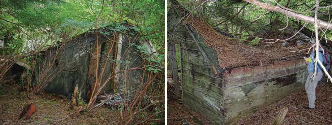
A dilapidated but standing cannery cabin off U.S. Mineral Survey 560 to the west, on USFS land, still has remnants of magazine pages papering the ceiling and parts of the walls (Figures 34-35). The building is a one-story frame affair with many exposed interior studs, and likely represents one of the five cabins numbered four through eight at the far west end of the 1942 map (Figure 12); the 1962 map (Figure 25) was not carried far enough west to include those buildings. Papering the cabin’s ceiling are pages from The Saturday Evening Post and Collier’s Weekly magazines, with at least one page dated 1919.

Corresponding to either the centrally located “GUEST HOUSE” or “CABIN” plotted on the 1962 map (Figure 25) is a small one-story frame building missing its windows. The cabin measures approximately 12’ x 20’ and has board-and-batten siding (Figure 36), but was not inspected further.
Building Ruins
In contrast to the five standing buildings left from the cannery and internment periods are numerous features classed here as building ruins. The distinction is an arbitrary division of the integrity continuum; one criterion considered is whether a building could be made habitable (a term relative to the experience and fortitude of the potential inhabitant). The brief field investigation at the Funter Bay cannery allowed photography of many building ruins and correlation of some with the 1942 and 1962 maps. Completely gone by 2008 were the main cannery building, warehouses, power house, machine shop, parts room, store, and mess hall. Remaining were remnants of the Filipino House from the cannery era, as well as wrecked Quonset huts, frame cabins, and outhouses from the Aleut internment period.
Of the pair of two-story bunkhouses from the cannery period – the China House and the Filipino House – only the latter (the westernmost example) survives in close to a recognizable form (Figure 37). Visible in the twisted pile of lumber are walls constructed of 2” x 4” studs covered with diagonal 1” x 6” plank sheathing, overlain by tarpaper and 1” x 4”drop siding. Window and corner trim boards are coated in a faded, oxidized green paint. Pieces of corrugated metal roofing protrude from the pile, as do round untreated pilings approximately 10” in diameter.

Of the wartime buildings erected at the Funter Bay cannery, the Quonset huts are easily identified by their steel metal frames. A group of three and a group of two Quonset huts were plotted on the 1962 map (Figure 25), and the remains of all five were found in 2008. The trio appear in an archival photograph (Figure 26), and were found in their original location (Figure 38). The other two were found in their plotted 1962 locations (which likely represent their 1942 locations as well). None of the Quonsets have any corrugated metal roofing or siding left, and likely the sheets were salvaged by locals long ago. The steel frames have mostly collapsed, and scraps of plywood and beaverboard are visible among the debris.

Two sets of cabin ruins were found corresponding to the two rows of “HOUSES” built for Aleut evacuees in 1942-43 behind the Filipino and China bunkhouses (Figure 25). A group of five buildings near the pair of Quonset huts are tumbling down but most still have at least one standing wall (Figures 39-41).
The 1942 cannery map shows two outhouses: one over the intertidal zone reached by a boardwalk from the China House, and another along the shore 500’ to the northeast (Figure 12). The example near the China House is likely the one shown in Figure 19. One of two small building ruins hanging off the bluff northeast of the industrial area in 2008 (Figures 42-43) likely represent the second outhouse mapped in 1942 – the one further to the northeast (Figure 12). Other building ruins not observed during the brief 2008 field investigation likely remain to be found.

The huge wood-stave oil tank once located at the peninsula’s point (Figure 14) and the water tank upslope from the two-story bunkhouses (Figure 25) were both demolished years ago, but the water tank foundation remains in place. It consists of about two dozen untreated round pilings supporting heavy timber stringers, which in turn supports a circular plank platform (Figure 46). Moss and small trees and shrubs have gained a footing on the rotten platform, which sags over the pilings in several places.
The cannery had at least two and possibly more water sources – all inadequate for the cannery’s commercial operation. Near the carpenter shop the water table is high and a dark pool of water about 14’ across with a low berm around it obviously represents an improved source, but the dark muskeg water was not potable. A dam was also built to tap a creek at the far northeast edge of the 1962 cannery map (Figure 25, upper image), near the Aleut cemetery, and it was still in place in 2008. The modest structure consists of two parallel rows of small pilings stretching across the bottom of the creek, each held in place by a horizontal log (one upstream and another downstream), with gravel filling the space between (Figure 47).
A 2” galvanized steel pipe protrudes downstream from the dam face. The cannery’s industrial compound was built on pilings over a short reef protruding into Funter Bay, creating another feature type observed Figure 51. Two large fuel oil tanks of about 1000 gallons each are located behind Gordon Harrison’s cabin (left), probably in or close to their original position from the cannery days in 2008. Circular depressions about 12” in diameter and up to 10” deep are carved into the bedrock where the pilings were set beneath what would have been the east warehouse.
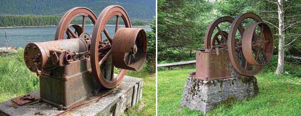

Stationary equipment observed in 2008 consisted of three machines, each a low-horsepower (10-20 hp range) gasoline engine affixed to a concrete pedestal. One large Fairbanks Morse engine sits prominently in a grassy clearing to mark the machine shop’s location (Figure 48). A second Fairbanks Morse engine missing its cylinder is located at the former power house site (Figure 49). A third gasoline engine of unknown manufacture, also minus its cylinder, is located inland among second-growth forest (Figure 50).
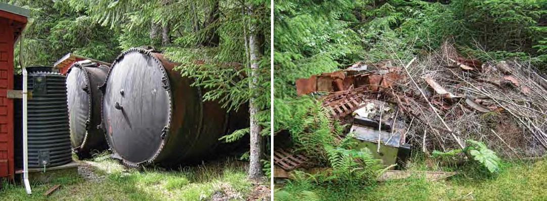

Several other features at the cannery are large but not stationary. Two cylindrical fuel oil tanks of about 1000 gallons each are located behind Gordon Harrison’s house (Figure 51). They may be in their original position (Figure 25). The tanks are identical to the one beside the enclosed little water tank near the old watchman’s cabin (Figure 33). A debris pile north of the superintendent’s house site contains mangled strap steel representing dozens of racks to hold cans in the cannery retorts (Figure 52). The cannery grounds undoubtedly hold smaller features like coal scatters (Figure 53) that escaped observation during the brief 2008 investigation.

Aleut Cemetery
The cemetery ( JUN-975) in which both St. George and St. Paul interred their dead during the war is located near the cannery dam (Figure 47), northeast of the separate parcel on which former cannery caretaker Harold Hargrave once resided. Management of the land may have shifted from USFS to Alaska with the creation of a state marine park at Funter Bay (Zacharof 2002), but the state park as mapped does not include the cemetery (Reid 1994:165), and agency officials were not able to verify the transfer. Twenty-three graves are marked on the west side of the creek, on a low rocky bench otherwise surrounded by the stream canyon’s steep sides. The surrounding forest is composed of second-growth spruce and hemlock. A wood arch painted white has been erected where the trail from saltwater enters the cemetery, and 18 of the graves have white-painted wood Russian Orthodox crosses (Figure 54). The graves are roughly parallel and each has a marker at the end nearest the creek. Vertical wood plank borders that once outlined the graves (according to archival photographs) are gone and most of the graves are now outlined with rocks placed there in 2000 (Zacharof 2002). The wood cross at the head of each grave is made of 2” x 2” stock, to replace older wooden markers made of 2” x 4” stock which have been left inside the grave outline (Figure 55). Colorful paper-and-plastic icons have been affixed to the centers of most crosses, and at least one plastic flower arrangement was noted. Associated with five individual graves are stone monuments (of which at least one postdates WW II). The Aleut cemetery at Funter Bay is well-maintained under the remote circumstances. The 2000 “restoration followed Orthodox Church doctrine...” (Zacharof 2002). As part of this investigation, AHRS number JUN-975 was acquired for the site to distinguish it from the cannery property.
Summary
The Funter Bay cannery has been cleared of most old buildings and subdivided into residential lots, with some original cannery features intruding onto adjacent USFS land. Three new residences have been built, joining the only original cannery dwelling (the watchman’s cabin) to total four houses on the property. Four other cannery buildings remained standing in usable condition in 2008: the carpenter shop, a small enclosed water tank, and two small frame cabins. Otherwise the cannery’s buildings are in various states of ruin – mostly collapsed and decaying into the archaeological record.
Those building ruins included several that could be correlated with cannery maps (Figures 12, 25), such as the cannery’s Filipino bunkhouse. The twisted wrecks of five Quonset huts erected during the war are still visible in their original locations as a group of three and another group of two. Two separate alignments of rotting lumber represent one row of five small frame cabins and a second row of three, all built during the war for Aleut families. Two outhouse ruins were still visible in 2008.
Other features observed at the Funter Bay cannery included the water tank foundation, water impoundment dam,boardwalk alignments, piling depressions in the intertidal bedrock, debris piles, and coal scatters.
The Aleut cemetery that served both Pribilof villages at Funter Bay is not far from the cannery and has been maintained by Funter Bay residents and by Aleut relatives who occasionally visit. The cemetery, Quonset huts, frame cabin ruins, and outhouse ruins would appear to be the primary elements reflecting the Aleut WW II relocation experience at the site.

Though artifacts evoking the Aleut experience were not observed at the site, in 1982 or 1983 Funter Bay resident Phil Emerson found a handmade wooden toy boat (Figure 56) tucked in the rafters of a bunkhouse being salvaged for material. Its details suggest an ocean-going ship. The hull is one piece of wood, with four separate pieces added to make the cabin, pilot house, and stack. The top of the stack is painted black. Small ferrous nails fore and aft clasp the stubs of mooring lines, and the starboard nail still has a piece of string attached. The bottom of the hull has a dark stain representing either faded paint or a watermark from use. Since the bunkhouses held only adult cannery workers during commercial operation, it is likely the toy was made by a St. Paul adult for a child during the relocation years. Perhaps it was intended to represent the ship that would someday return the villagers to their home in the Bering Sea. The toy is a poignant symbol of the Aleut experience at Funter Bay.
Last updated: February 14, 2021