The National Historic Landmark Program
Designed by Frank Broderick, Archgraphics. It is adapted from Die Goldsucher am Klondyke: aus den Erlebnissen eines jungen Deutschen, by Eginhard von Barfus, a German volume on the goldrush, located in the Alaska State Library, Historical Collections.
The National Park Service administers the National Historic Landmark (NHL) Program for the Secretary of the Interior. The NHL Program focuses attention on historic and archeological resources of exceptional value to the nation as a whole, by recognizing and promoting the preservation efforts of private organizations, individuals, and government agencies. Designation of NHLs also furthers the educational objective of the Historic Sites Act of 1935, by increasing public awareness and interest in historic properties. NHLs are our nation’s most important prehistoric and historic cultural
resources. Of the only 2,200 NHLs nationwide, 47 are located in Alaska. They are an irreplaceable legacy.
NHLs evolve from theme studies or surveys of properties related to an aspect of American culture. The NHLs described in this brochure all represent a range of national themes including: exploration and settlement, military, and industrial development. The five NHLs also have one theme in common, The Alaska Gold Rush, which traces part of the history of searching for gold in the state and neighboring Canada from 1897-1904. Most of the Gold Rush NHLs are privately owned and preserved. However, the National Park Service and Parks Canada manage some of the structures and lands involved with these NHLs.
On August 5, 1998, after 30 years of planning, Canadian First Nations representatives and Canadian and United States officials dedicated the Klondike Gold Rush International Historical Park. The 13,000 acre park is a combination of the Klondike Gold Rush National Historical Park on the U.S. side and the Chilkoot Trail National Historic Site on the Canadian.
This designation celebrates the shared history of the United States and Canada and recognizes the efforts of both nations to preserve Klondike history. Artifacts and historic archeological sites are an important part of our national heritage and are protected by federal and state laws. It is illegal to excavate, damage, remove, sell, or transport archeological and historic resources located on Federal or State land without proper permits. Please enjoy our national heritage, but leave all archeological and historic material where you find it so others can enjoy it as well.
Visit https://www2.cr.nps.gov/nhl/ for more information on the National Historic Landmark Program. For more information on the Klondike Gold Rush National Historical Park, visit our website at https://www.nps.gov/klgo/. For information on the Parks Canada Chilkoot Trail National Historic Site visit http://fas.sfu.ca/parkscan/ct/.
The Stampede North: The Alaska Gold Rushes, 1897-1904
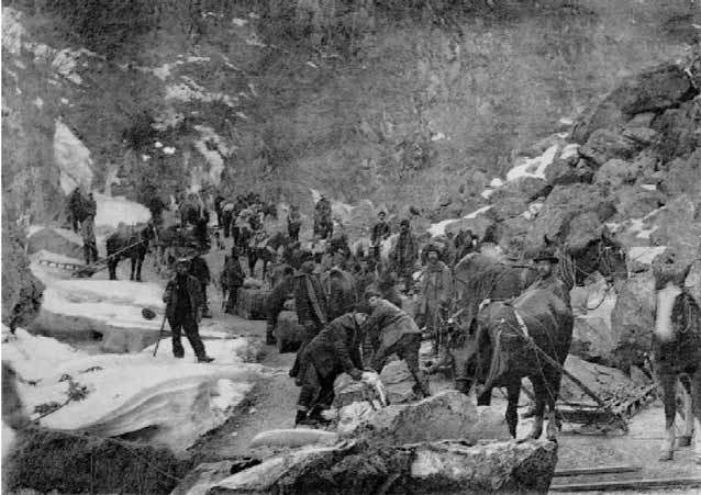
NPS Photo courtesy of the Anchorage Museum of History and Art
“At 3 o’clock this morning the steamship Portland, from St. Michaels for Seattle, passed up [Puget] Sound with more than a ton of gold on board and 68 passengers.” When this magic sentence appeared in the July 17, 1897, issue of The Seattle Post-Intelligencer, it triggered one of the last and greatest gold rushes in the history of North America. The great gold rush attracted worldwide attention and caused the first true exploration of Alaska and the Yukon by outsiders since its acquisition from Russia in 1867. From the early 1880s to the eve of World War I, the gold discoveries stretched from the Bering Sea to the Canadian Interior and from the Gulf of Alaska to the Brooks Range. While a few individuals “struck it rich,” most of the gold strikes did not meet the miners’ dreams of riches.
The discovery of gold set off two great rushes, the Klondike rush to goldfields near Dawson City and the rush to the hills beyond Cape Nome. Fueled by the economic depression of the mid-1890s, the dream of untold riches caused a mass migration to the north country from the United States and Canada. Beginning in 1897, argonauts set off by ship from Seattle or San Francisco and headed north to Dyea or Skagway, after which they headed up trails, then floated down the Yukon River to the Klondike goldfields. Two years later, thousands would head up to Nome by ship to take advantage of the second gold rush.
The majority of these people were unprepared for what lay ahead. Many would-be miners had never even pitched a tent as they set off into the wilderness. Merchants, honest and corrupt, were eager to provide supplies and expertise to these fortune hunters at a very healthy profit. These people became the true success stories of the Gold Rush. As a result of the mining rushes of the late 1890s, Alaska’s population grew from 4,298 whites in 1890 to 30,293 in 1900 as hopeful miners pushed north in search of riches. When the miners arrived, fur companies were the major power in the north. Eager to gain more economic and political control, the miners pushed for Alaska to become a territory, which concluded the powerful reign of the fur companies. New people also meant a need for a permanent police presence.
The federal government created a series of garrisons, such as Fort William H. Seward, to maintain order in the territory. The gold rush also affected Alaska Natives. In Southeast, the Tlingit and the First Nations groups in Canada had a long-standing tradition of trade. The Tlingit brokered goods between the fur companies and the First Nations of the Canadian Interior. After the gold strike, fur companies went farther into the Interior to establish posts which cut off the trade relationship between the Tlingit and the First Nations. The Tlingit continued to trade, but by the 1890s the way of life of many Alaska Native groups had changed dramatically as the miners strengthened their presence.These stampeders shaped the settlement of the land, the history, and the spirit of the north country for generations.
Fort William H. Seward National Historic Landmark
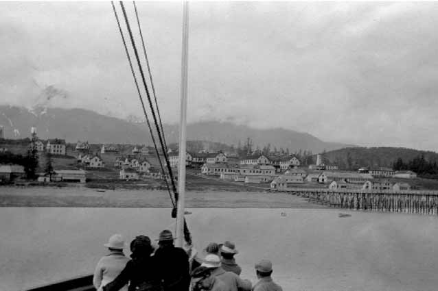
NPS Photo courtesy of the Anchorage Museum of History and Art
Then
The United States Government established Fort William H. Seward to maintain law and order over the Chilkoot, Chilkat, and White Pass trails. It also provided a military presence to help guard the U.S.-Canadian border. Fort Seward was the last of eleven police garrisons established in the District of Alaska during the gold rush period. The fort’s remoteness classified it as a foreign duty post for the U.S. Army. When crews completed construction in 1904, Fort Seward included eighty-five buildings and a large central parade ground.
However, the army never erected fortifications, since the main duties of the soldiers were fire watch, marching, and rifle practice. The army changed the name of the fort to Chilkoot Barracks in 1922. Between 1925 and 1940, the fort was the only active military post in Alaska. During World War II, the post became an induction and rest camp for military personnel stationed in the area. Early in 1946, the army deactivated the post and declared it surplus. A group of veterans purchased the fort in 1947 and established the city of Port Chilkoot. The residents voted to become part of Haines in 1970 and the area was once again know as “Fort William H. Seward.”
Now
The Secretary of Interior listed Fort Seward on the National Register of Historic Places on April 11, 1972, and officially designated it a NHL on June 2, 1978. Port Chilkoot Company stockholders and their descendants own most of the property and have converted several of the buildings into bed and breakfasts, hotels, and gift shops. A walking tour of Fort Seward showcases the many historic structures, including the commissary, the remains of a company barracks building, the historic fort headquarters and post office, Officer’s Row, and the guard house. The buildings are a clapboard and brick chimney military design, common in the Lower 48, but rare in Alaska.
The town renovated the education/recreation hall into the Chilkat Center for the Arts in 1967. Alaska Indian Arts, Inc. erected Totem Village, which includes a replica of an Indian Tribal House, Yukon
Trapper’s Cabin, and several other caches and a totem, on the parade grounds. Within the various buildings, local artists work and sell their art. This landmark represents the role of the U.S. Army in
maintaining order in Alaska’s Gold Rush era.
Access
Haines is located at the south end of the Haines Highway. Visitors driving the Alaska Highway may take the cutoff at Haines Junction, 155 miles north, of Haines. Bus service is also available from the surrounding area. Air taxi service is available from Juneau and Skagway. Ferry service on the Alaska Marine Highway also runs from Juneau and Skagway to the terminal in Lutak Inlet north of Haines. Contacts: the Haines Visitor Bureau at PO BOX 530, Haines, AK 99827, or call (800)458-3579, or (907)766-2234, or on the web at http://www.haines.ak.us/.
Skagway Historic District and White Pass National Historic Landmark
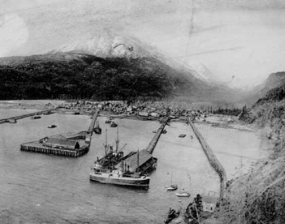
NPS Photo courtesy of the Anchorage Museum of History and Art
Then
Dubbed the “Gateway to the Klondike,” Skagway was the starting point for many gold rush stampeders. In 1897, it was Alaska’s largest town with a shifting population of up to 10,000. However, prospectors found the nearby White Pass Trail to be difficult because of the heavy rain and often stayed in Skagway, causing overcrowding and increased prosperity for local businesses. The town became infamous for its lawlessness due to Jefferson Randolph “Soapy” Smith and his nine month reign as mastermind of a ring of gambling, prostitution, thievery, and murder.
The city engineer, Frank Reid, killed Smith in a blazing shoot-out on July 8, 1898. In the spring of 1898, an Irish contractor persuaded English investors to build a railroad over White Pass to Whitehorse in the Canada. Crews began construction on the White Pass & Yukon Route Railroad in 1898 and finished July 1900. Yet, the rush had peaked and many prospectors moved on. The population decreased as gold production declined, dropping from 3117 people in 1900, to just 872 in 1910. Skagway survived as a shipping and supply center for the miners and trappers of the Klondike and other Canadian mining districts. It later became a supply point during the construction of the Alcan Highway.
Now
The Secretary of Interior designated the Skagway Historic District and White Pass a NHL on June 13, 1962, which includes approximately 100 original buildings of the 1897-1910 period. The Skagway Historic District provides the finest example of a town that played a significant role in a northern mining stampede. The White Pass & Yukon Route Railroad still operates with daily excursions. The old railroad depot now houses the Klondike Gold Rush National Historical Park Visitor Center, which offers an informative movie on the Gold Rush and daily walking tours through the historic district where one can see restored buildings with false fronts, a goldrush saloon, and wooden sidewalks. The Arctic Brotherhood Hall on Broadway contains The Trail of ’98 Museum. Also of interest is the home and property of Captain William Moore, the originalhomesteader of Skagway. A “ton of goods” display at the National Park Service Visitor Center illustrates how much the Canadian Mounties required the stampeders to pack when going over the pass.
Access
The airports at Juneau, Haines, and Glacier Bay have regular air taxi flights. Train and bus service is available. Cruise ships and ferries serve Skagway. Contacts: Klondike Gold Rush National Historical Park, PO BOX 517, Skagway, AK 99840, (907) 983-2921, https://www.nps.gov/klgo/; the Chamber of Commerce, PO BOX 194, Skagway, AK 99840, (907) 983-1898, http://skagchmbr.org/; the Skagway Visitor’s and Convention Bureau PO Box 415, Skagway, AK 99840, Phone (907) 983-2854, http://skagway.org/; and in Canada: Parks Canada, #205 - 300 Main Street, Whitehorse Y1A 2B5 (867) 667-3910, http://fas.sfu.ca/parkscan/ct/.
Chilkoot Trail and Dyea Site National Historic Landmark
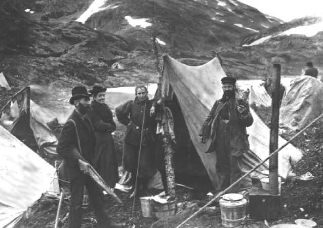
Special Collections Division, University of Washington Libraries, Photo by Frank LaRoche, Negative #1455.
Then
Before the Taiya River Valley became an active route for the gold stampeders, the Tlingit used the route to trade with the Athabascans. Lester A. Beardslee, a United States naval captain, negotiated with the Tlingit to share the trail with prospecting parties. Tlingit guides accompanied the first party over in May 1880, and transported the miners’ gear for a fee. This trip set the foundation for the Tlingit packing business, which thrived until the Gold Rush.
Located at the head of the Chilkoot Trail, Dyea erupted from a small trading post to a major port in 1897 after word of the Klondike gold discovery reached Seattle and San Francisco. Several trailside communities and two smaller clusters of tents and shacks soon developed along the U.S. side of the trail. Dyea did not have a steady population increase like Skagway; because the Chilkoot Trail was less difficult to traverse than Skagway’s White Pass, thus fewer people remained in Dyea for extended periods of time. The Chilkoot Trail, considered by some “the meanest 33 miles in history,” remained the prevailing route to the Klondike until April 1898, when an avalanche took more than 60 lives and frightened many people away. With the completion of the White Pass & Yukon Route Railroad in 1900, the Chilkoot Trail declined rapidly as a route to the gold and Dyea became a ghost town.
Now
The Secretary of the Interior designated the Chilkoot Trail and Dyea Site a NHL on June 16, 1978. The visible remains of the gold rush are foundation ruins, decaying old boat docks and pilings, wagon roads, the remains of the aerial tramway system, and the Slide Cemetery, where the 65 victims of the April 3, 1898 avalanche are buried. Dyea remains a major historic archeological site and is part of Klondike Gold Rush National Historical Park. From 1900 to 1960, very few people hiked the Chilkoot, but since then the trail has witnessed increased numbers of recreational hikers.
The National Park Service and Parks Canada now maintain the trail with campsites and rest facilities. Historic ruins are visible along the trail from Dyea to Bennett Lake. While the trail is of great historic value, it also has many natural wonders of the Pacific Northwest Coastal Forest, Alpine Tundra, and subalpine Boreal Forest zones. Mountain goats, brown and black bears, and moose inhabit the trail area. Hikers must carry a back country permit, available through the Trail Center in Skagway or Parks Canada. Travel time over the trail is 3-4 days for most hikers.
Access
From Skagway, visitors or hikers may walk, bicycle, or take a taxi to Dyea. Contacts: the NPS Visitor Center in Skagway, or in Canada: Parks Canada, #205 - 300 Main Street, Whitehorse Y1A 2B5 (867) 667-3910 or on the web at http://fas.sfu.ca/parkscan/ct/.
Eagle Historic District National Historic Landmark
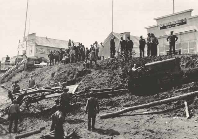
NPS Photo courtesy of the Anchorage Museum of History and Art
Then
Eagle began as a fur trading post around 1880 and remained that way until the Klondike gold rush stampede pushed westward into Interior Alaska. Gold discoveries on nearby American Creek in 1897 caused the U.S. Army to build Fort Egbert near Eagle to maintain law and order along the upper reaches of the Yukon River in 1899. Locals worried about hungry gold-seekers attempting to steal supplies. Furthermore, the government needed to “show the flag” during the dispute over the U.S.- Canadian border.
Judge James Wickersham, the first magistrate of a federal court in the District of Alaska responded by building a large courthouse in Eagle. His domain stretched from Eagle to the Aleutian Islands in southwest Alaska. Merchants erected substantial stores to supply stampeders at the last river stop on the United States side. The military declared Fort Egbert the headquarters for the District of North Alaska, and it eventually became the control station for the Washington-Alaska Military Cable and Telegraph System. Eagle’s proximity to the river and communications center made it a hub of transportation and business for many years. When the mining boom began shifting focus to other areas in 1911, the Army closed Fort Egbert, although a signal corps detachment remained until 1936.
Now
The Secretary of the Interior designated Eagle Historic District a NHL on June 2, 1978. Eagle is one of the best-preserved boom towns commemorating the mining era in Alaska. Most of the buildings are log cabins, which gives a glimpse and feeling of the town as it must have appeared during the gold rush era. The local citizens have put in a great effort to preserve these gold rush structures. Within the city, the local government and private citizens have restored several historic buildings, such as the old Customs house and the Federal Courthouse—both serving as museums.
The old parade grounds are currently in use as a grass airstrip by local citizens. The U.S. Bureau of Land Management maintains most of Fort Egbert, while the Alaska Highway Department controls the rest of the old military reservation. The post cemetery, now the city cemetery, contains many graves of pioneers with turn of the century headstones. Numerous other buildings are in private ownership, including Judge Wickersam’s residence.
Access
Eagle is over 200 air miles northeast of Fairbanks and air service is year round. Visitors can also reach Eagle via the Taylor Highway, a 160-mile dirt and gravel road running north from Tetlin Junction on the Alaska Highway. However, Taylor Highway is usually closed from October 15 to April 15. Tourboats from Dawson go into Eagle during the summertime. Contacts: the National Park Service Visitor Center at PO BOX 167, Eagle, AK 99738, (907)547-2233. The Eagle Historical Society offers daily walking tours of the historic district.
Cape Nome Mining District Discovery Sites National Historic Landmark
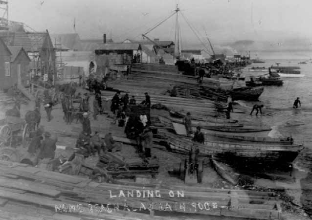
NPS Photo courtesy of the Anchorage Museum of History and Art
Then
In September 1898, “Three Lucky Swedes” discovered placer gold deposits in Anvil Creek. Jafet Lindeberg, Erik Lindblom, and John Brynteson were traveling up the Snake River testing its tributaries, when fate brought them to Anvil Creek and gold. The news of gold and a flood of fortune seekers created the tent city of “Anvil Creek.” Less than a year later, soldiers at nearby Fort Davis discovered gold on the beaches of Nome.
The beach discovery created a frenzy, since a miner could not stake a claim on a beach and sand did not require back-breaking digging. Many individuals crowded onto the shores of the Bering Sea seeking an easy, quick fortune. As a result, Nome became a booming gold rush town and the focus of Alaska’s greatest gold rush, both in gold yield and the increase in population. By 1900, miners excavated $4.7 million from the Seward Peninsula, the largest portion, $1.75 million, coming from Anvil Creek.
By 1900, over 20,000 people landed on the beaches of Nome causing a population expansion from just 250 people four years earlier. Gold production reached its peak in 1906. Nome’s population fell to 2,600 within the next four years due to the decline in gold production and mining activity. In total, the boom era of 1899 to 1910 yielded over $46 million in gold, including two large gold nuggets worth about $1500 each.
Now
The Secretary of the Interior designated Cape Nome Mining District Discovery Sites a NHL on June 2, 1978. A few Gold Rush era buildings remain, including the Discovery Saloon and St. Joseph’s Catholic Church, yet fires and violent storms erased many of the buildings and structures from the era. Many prospectors left artifacts from this time, including mining equipment, which can be seen around the town and surrounding area.
The Carrie McLain Museum houses a Gold Rush exhibit, which shows how miners extricated the gold from the creek and beaches of the area and how they survived in the local environment. The areas of the discovery sites reflect the many scars left from the mining activity including debris, evidence of cuts and ditches, and severe disturbances on the earth’s surface. Today, the lure of gold still draws people to Nome.
The beaches of Nome now have a sea wall to help prevent the erosion caused by the Bering Sea. The current owner of the Snow Creek site actively mines the claim. Visitors should obtain owner’s permission before entering the claim area.
Access
Visitors may take flights from Anchorage or Fairbanks to Nome. Anvil Creek Discovery Site is accessible by vehicle, as are the Lindblom and Snow Creek Discovery Placer mines. Visitors should make local inquiries and obtain permission prior to going to these areas. The sites are privately owned.
Contacts: the Nome Visitor and Convention Bureau, PO Box 240 Nome, AK 99762, (907) 443-5535 or on the web at http://www.alaska.net/~nome/.
Last updated: December 29, 2016
