Last updated: April 15, 2025
Article
Wetland Inventory Resource Brief

NPS Photo
Background Information
Wetlands are unique plant communities at the interface of land and water. Wetlands have saturated soils, water-loving plant species, and seasonal or year-round standing water. Great Smoky Mountains National Park (GSMNP) is home to many wetland types including open marshes, floodplain forests, and high-elevation stream headwater seeps. Wetlands occupy a small fraction of the park’s landscape but harbor high amounts of biodiversity including plants, amphibians, birds, mammals, and insects.Wetlands in GSMNP are also vulnerable to stress. Wetland stressors include climate change, air pollution (which can increase wetland acidity and nutrient levels), invasive plants, wild hogs, roads and developed areas, and historical wetland drainage.GSMNP has been collecting data on wetlands throughout the park since 2010. This brief highlights key findings from this wetland inventory project.
Finding GSMNP wetlands
In 1984, the U.S. Fish and Wildlife Service surveyed the park for wetlands via aerial imagery. Yet, with 96% of the park covered in dense canopy, the survey missed many wetlands and misclassified many other areas.
In 2010, we began the GSMNP wetland inventory project: a wetland database covering the entire park. From 2010 to 2015, we surveyed for wetlands using a simple spatial model that isolated areas of low slope. However, the utility of this model decreased in steeper high elevation reaches of the park. In 2016, we developed a new wetland habitat model based on 24 environmental variables. This model predicts wetland habitat very well at both high and low elevations.
To assess the status of each wetland in our inventory, we collect data on several variables, including:
1) Location and size (Fig. 1)
2) Plant community
3) Presence and type of stressor
4) Water source, landscape position and structure

NPS Photo
Status and Results
Wetland abundance and diversity
From 2010 to 2019, we mapped and inventoried 596 wetlands totaling 117 acres. Of these, about 80% occur below 3,500 ft (low-elevation) with the remaining 20% occurring over 3,500 ft (high-elevation). Our new wetland habitat model increased our high-elevation detection rate five-fold, highlighting the utility of spatial data and technology for on-the-ground efforts.
We collected 14,272 records of 514 unique plant species. While wetlands cover less than 1% of the park’s area, they represent over a quarter of GSMNP plant diversity!
We also documented 22 unique wetland community types (Fig. 2), including two of global conservation concern (ranked as ‘Critically Imperiled’ by NatureServe). These two wetland types—montane alluvial floodplain slough forests and Mt. Leconte Blue Ridge high-elevation seeps—merit priority monitoring and conservation.

NPS Photo
Wetland stressors
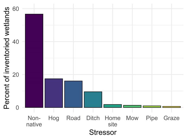
Fifty-seven percent of wetlands inventoried contained one or more non-native plant species (Fig. 3), while 18% contained four or more. We recorded 51 different non-native plant species. The most common were Japanese stiltgrass, multiflora rose, Japanese honeysuckle, and privet.
The three other most common stressors were wild hogs; roads, trails and developed areas; and historical ditching (Fig. 3).
Management Strategies
With inventory data collected from nearly 600 wetlands spanning ten years, GSMNP now has one of the largest wetland inventories throughout the NPS and country. Data from the project help the park manage invasive plant species, restore historical wetland areas, and protect priority wetlands from wild hogs, grazing, mowing, and roads and trails projects.We plan to move into a monitoring phase of the project, which will help us understand how ongoing changes and restoration activities affect GSMNP wetlands through time. Monitoring would include sampling a suite of wetland ‘vital signs’ every 3-5 years from a subset of wetlands in this inventory. We plan to implement the monitoring protocol in 2022.
So What?
Far from being ‘useless swamps,’ wetlands provide many important values. These include:-
Improving water quality
-
flood protection
-
carbon sequestration
-
wildlife habitat
- aesthetic and recreational opportunities
Call to Action
When we protect wetlands, we also protect our safety and wellbeing. Visitors can help protect wetlands by limiting the use of pesticides and fertilizers, landscaping with native plants, collecting and disposing of litter, and minimizing stormwater run-off.
More Information
Tom Remaley, e-mail us
NPS Profile: What’s in our wetlands?
Using spatial modeling to improve wetland inventories in Great Smoky Mountains National Park
GSMNP Inventory data package (NPS IRMA)
GSMNP Wetlands geospatial database (ArcGIS Online)
