Last updated: November 9, 2020
Article
Weather and Climate Monitoring in Glacier Bay and Klondike

NPS Photo
How is climate in the region changing over time?
Principal Researchers:
Andrew Bliss (NPS Southeast Alaska Network)Michael Bower (NPS Southeast Alaska Network)
Cory Thole (NPS KLGO)
John Hinrichs (NPS KLGO)
Tom Ziomek (NPS Southeast Alaska Network)
Dates:
Ongoing since 2015Introduction and Methods
Weather and climate (long-term averages and variations of weather) are important for a wide variety of organisms, including people. Beyond helping us decide what to wear, knowing about the weather aids in planning trips to remote backcountry sites in our national parks via boat or airplane.
Weather and climate are also crucially important to the glaciers of the park. Winter snowfall adds mass to the glaciers while warm summer temperatures melt glacial ice, leading to glacier mass loss. Most of the glaciers in the parks have been retreating since the Little Ice Age ended roughly 150 years ago, but the retreat is expected to continue well into the future as human-caused climate change continues.
Operating weather stations allows us to simultaneously aid operations of the parks and provide baseline measurements of climate change.
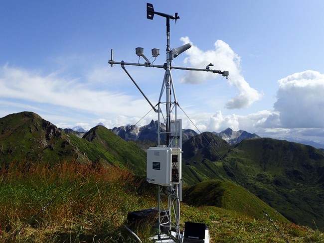
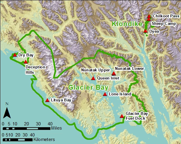
We maintain 8 weather stations in strategic locations across Glacier Bay National Park and 3 in Klondike Gold Rush National Historical Park. Each weather station records air temperature, relative humidity, wind speed, wind direction, rainfall, snow depth, solar radiation, and soil temperature. Data are uploaded via satellite so that measurements can be viewed in near real-time by the public and park staff:. Data are also stored on board the climate station and later downloaded and archived for quality control and analysis of long-term trends in weather and climate.
Study Area

NPS / Southeast Alaska Inventory & Monitoring Network (SEAN)
Results

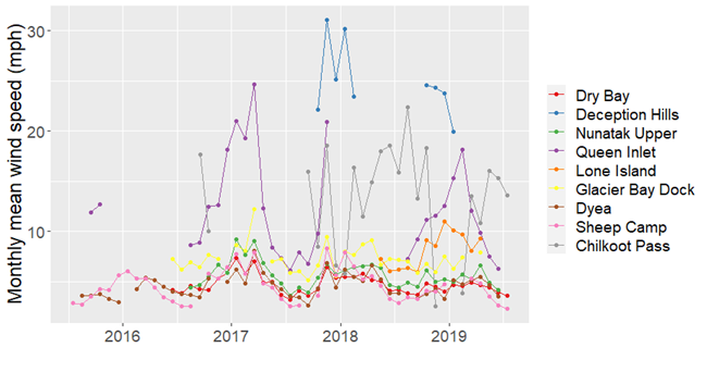
Deception Hills, Queen Inlet, and Chilkoot Pass are the windiest sites - so windy that multiple wind sensors have been destroyed. Low elevation, forested sites have the lowest winds but show faster winds in winter and calmer conditions in summer.

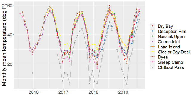
These stations do not have long enough records to assess climate trends at this point. Through comparisons with long-term stations in Juneau and Yakutat we hope to be able to estimate recent climate in Glacier Bay. Other researchers have been working on longer-term climate changes too, for example by looking at variations in tree rings.
Learn More
The data from these stations and detailed descriptions of station installation and data processing are available from the NPS Data Store:
https://irma.nps.gov/Datastore/Reference/Profile/2271988
https://irma.nps.gov/Datastore/Reference/Profile/2238818
Near real-time data are available at:
https://www.weather.gov/ajk/LatestObsSEAK
