Last updated: May 13, 2024
Contact Us
Article
Trail of Tears Commemorative Park Exhibits Audio Description

NPS Exhibit
A Winter Camp Exhibit Audio Description
-
Trail of Tears Commemorative Park - A Winter Camp Exhibit Audio Description
Interested in the Trail of Tears in Hopkinsville? Take a look at this interpretive exhibit and listen to the audio description.
- Date created:
- 05/13/2024
A Winter Camp
A Winter Camp. 718 words.
This panel is on the right of a pair that sits in the grass along a parking lot. As you face the panel, to the right there is a small log building with restrooms and a water fountain. Beyond that is a larger log building serving as a museum. Two parallel walkways cross left to right beyond the panel. The further path is on a slight hill along a wood rail fence. Brick columns with brass historic markers are set into the fence every few yards. At the end of the path to the left is a black metal fence surrounding two life sized statues, two raised gravesites, and two additional gravesites with brass plaque markers.
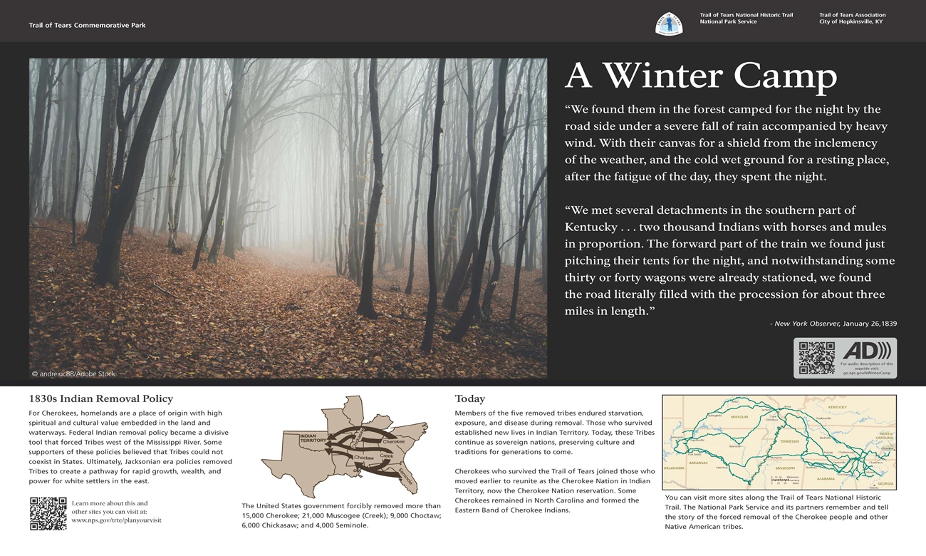
At upper left on this panel is a photograph of the view of a wide path heading away from us through woods. The trees are bare and partially hidden by fog. Brown leaves cover the ground which slopes slightly down to the right.
Text at the right has a quote from the New York Observer, January 26, 1839, which reads, "We found them in the forest camped for the night by the road side under a severe fall of rain accompanied by heavy wind. With their canvas for a shield from the inclemency of the weather, and the cold wet ground for a resting place, after the fatigue of the day, they spent the night. We met several detachments in the southern part of Kentucky . . . two thousand Indians with horses and mules in proportion. The forward part of the train we found just pitching their tents for the night, and notwithstanding some thirty or forty wagons were already stationed, we found the road literally filled with the procession for about three miles in length.”
At bottom left on the panel text reads, "1830s Indian Removal Policy. For Cherokees, homelands are a place of origin with high spiritual and cultural value embedded in the land and waterways. Federal Indian removal policy became a divisive tool that forced Tribes west of the Mississippi River. Some supporters of these policies believed that Tribes could not coexist in States. Ultimately, Jacksonian era policies removed Tribes to create a pathway for rapid growth, wealth, and power for white settlers in the east."
To the right of the text is a map of the southeastern United States from Florida to Texas, and as far north as Illinois. Wide dark arrows show movement west into Oklahoma, labeled as Indian Territory. The Cherokee were from the western Carolinas; the Creek from Georgia; the Seminole from Florida; the Choctaw from southern Alabama and Mississippi; and the Chickasaw from northern Mississippi ad western Tennessee and Kentucky. The caption reads, "The United States government forcibly removed more than 15,000 Cherokee; 21,000 Muscogee (Creek); 9,000 Choctaw; 6,000 Chickasaw; and 4,000 Seminole."
Next to the right more text reads, "Today. Members of the five removed tribes endured starvation, exposure, and disease during removal. Those who survived established new lives in Indian Territory. Today, these Tribes continue as sovereign nations, preserving culture and traditions for generations to come. Cherokees who survived the Trail of Tears joined those who moved earlier to reunite as the Cherokee Nation in Indian Territory, now the Cherokee Nation reservation. Some Cherokees remained in North Carolina and formed the Eastern Band of Cherokee Indians."
At bottom right is a map showing an area from the western Carolinas to eastern Oklahoma. A network of green lines crosses the map from east to west. The caption reads, "You can visit more sites along the Trail of Tears National Historic Trail. The National Park Service and its partners remember and tell the story of the forced removal of the Cherokee people and other Native American tribes."
Across the top of the panel is a black bar. At the left end text reads "Trail of Tears Commemorative Park." At the right end is the logo and text for Trail of Tears National Historic Trail. Other text reads, "Trail of Tears Association, City of Hopkinsville, Kentucky; National Park Service."
At the right side is the Audio Description symbol and text that reads, "For audio description of this wayside visit: go.nps.gov/AWinterCamp."
At bottom left is a QR code. Text reads, "Learn more about this and other sites you can visit at: www.nps.gov/trte/planyourvisit."
End of Description.

NPS Exhibit
Mourning at Camp Exhibit Audio Description
-
Trail of Tears Commemorative Park - Mourning at Camp Exhibit Audio Description
Interested in the Trail of Tears in Hopkinsville? Take a look at this interpretive exhibit and listen to the audio description.
- Date created:
- 05/13/2024
Mourning at Camp
Mourning at Camp. 473 words.
This panel is on the left of a pair that sits in the grass along a parking lot. As you face the panel, to the right is a small log building with restrooms and a water fountain. Beyond that is a larger log building serving as a museum. Two parallel walkways cross left to right beyond the panel. The further path is on a slight hill along a wood rail fence. Brick columns with a brass historic markers are set into the fence every few yards. At the end of the path to the left is a black metal fence surrounding two life sized statues, two raised gravesites, and two additional gravesites with brass plaque markers.
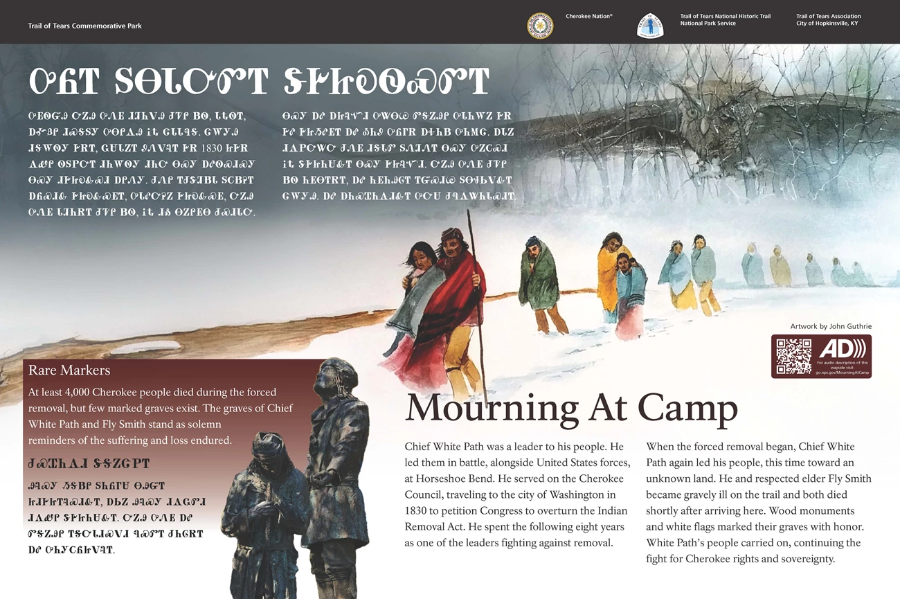
The background of this panel features a color illustration showing a line of Cherokee men, women, and children walking through snow from right to left. They are wrapped in colorful blankets and walk with heads bowed. In the upper right corner is a drawing of a great Horned Owl in full flight. At upper left is text written in the Cherokee language. At bottom right English text reads, "Chief White Path was a leader to his people. He led them in battle, alongside United States forces, at Horseshoe Bend. He served on the Cherokee Council, traveling to the city of Washington in 1830 to petition Congress to overturn the Indian Removal Act. He spent the following eight years as one of the leaders fighting against removal. When the forced removal began, Chief White Path again led his people, this time toward an unknown land. He and respected elder Fly Smith became gravely ill on the trail and both died shortly after arriving here. Wood monuments and white flags marked their graves with honor. White Path’s people carried on, continuing the fight for Cherokee rights and sovereignty."
At bottom left is an image of two Cherokee men. The one on the right stands looking up with hands held palms up. The other holds a rifle on front of him and stands with head bowed. Text to the left reads, "Rake Markers. At least 4,000 Cherokee people died during the forced removal, but few marked graves exist. The graves of Chief White Path and Fly Smith stand as solemn reminders of the suffering and loss endured."
Below that is more text in the Cherokee language.
Across the top of the panel is a black bar. At the left end text reads "Trail of Tears Commemorative Park." At the right end is the logo and text for the Cherokee Nation and the logo and text for Trail of Tears National Historic Trail. Other text reads, "Trail of Tears Association, City of Hopkinsville, Kentucky; National Park Service."
At the right side is the Audio Description symbol and text that reads, "For audio description of this wayside visit: go.nps.gov/MourningAtCamp."
End of Description.


