Last updated: April 7, 2025
Article
The Texas Freedom Colonies Project: Thick-Mapping Vanishing Black Places
National Center for Preservation Technology and Training
This presentation, transcript, and video are of the Texas Cultural Landscape Symposium, February 23-26, Waco, TX. Watch a non-audio described version of this presentation on YouTube.
Dr. Andrea Roberts, Texas A&M University
Dr. Andrea Roberts: Thank you so much for having me, and Perky Beisel, long fan of your work and glad to be a kindred spirit in our approaches.
So, in talking about the Texas Freedom Colonies Project, I'm essentially talking today about a process much like Perky's, that we call thick-mapping. And we engage in thick-mapping of vanishing black places. I'll walk you through our approach, but first I will give a review on what we're talking about when we say Freedom Colonies. What it is we do at the Texas Freedom Colonies Project, our approach, the Atlas, which is sort of the home of much of our work right now in working on the issue of visibility, and new initiatives coming down the pipe.
Dr. Andrea Roberts, Texas A&M University
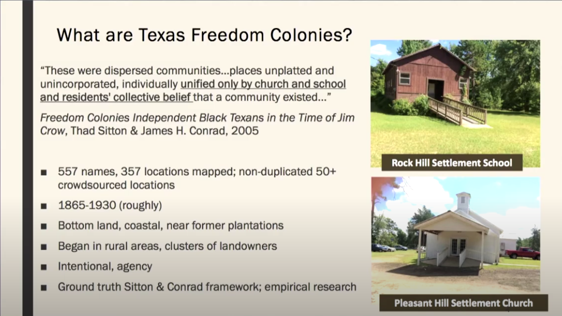
So just what are Texas Freedom Colonies? This picture is emblematic of sort of the origins of Texas Freedom Colonies because it's depicting the beginning of a settlement on the edge of a plantation. And in the WPA slave narratives, there are some people who share these stories of African Americans, even while enslaved, creating free spaces on the edge of plantations.
And so, Texas Freedom Colonies are, according to Sitton and Conrad, "dispersed communities, places unplatted, unincorporated, individually unified by only a church, school, and residents' collective belief that a community existed." In that last phrase, "residents' collective belief", is essentially what we're trying to get at with the Texas Freedom Colonies Project. Along with all of the remaining extant features, we're looking at their sociocultural geography that remains in the way of these collective beliefs and where they reside.
Dr. Andrea Roberts, Texas A&M University
Freedom Colonies were founded roughly between 1865 and 1930 in bottom lands. And they're distinct in that they're clusters of landowners, and these were intentionally created communities, not places that people were pushed to by default.
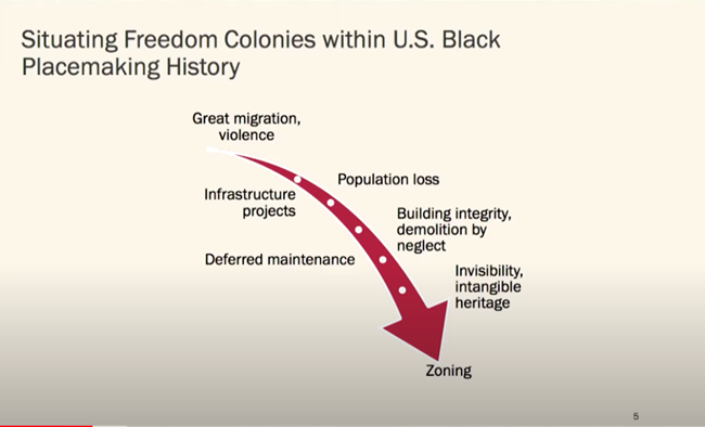
And so, to situate Freedom Colonies within the broader United States black placemaking history and movements, we can also think of places such as Eatonville in Florida, Nicodemus, Kansas. But what's distinct about Freedom Colonies, as I said before, is their intentionality and their status of often unmapped, not visible in public records for a number of reasons. And so the same problems that plague Freedom Colonies in Texas plague a lot of these historic black places around the United States. We can think of the great migration and the violence which originally pushed African Americans or encouraged them to seek opportunity and political asylum elsewhere in the United States, which led to a decline in population.
We have the intrusion of infrastructure projects and also disruption of circulation and connection between Freedom Colonies due to these infrastructure projects, deferred maintenance on buildings, and all of these things that compromise building integrity. And of course invisibility due to the remaining, understanding these places residing so much in intangible heritage.
And I say zoning at the end there because there are so many ways in which these communities have been zoned that lead to their decline, particularly including areas in which there is terrible environmental racism.
Dr. Andrea Roberts, Texas A&M University
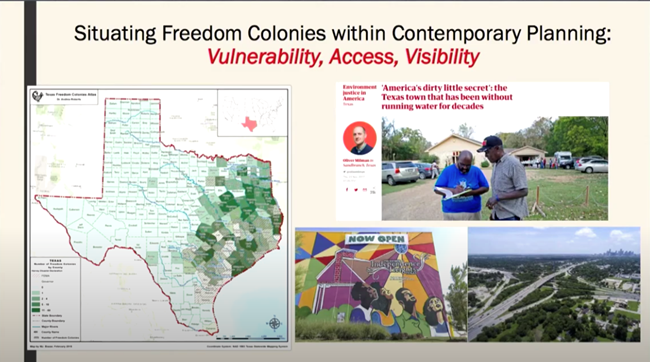
And so also what I want to do is situate Freedom Colonies within contemporary planning because much of our work is focused on just that. In thinking about the three key threats to the survival of these places, we can characterize it as thinking about vulnerability, access and visibility. Vulnerability due to their locations, historically in bottom lands, making them particularly susceptible to flooding. Access in that they have little access to resources. And because people don't know where they are, little access and interaction with professionals like yourselves. And of course the issue of visibility.
And so, what is the Texas Freedom Colonies Project? How do we attend to any of these grand challenges? So we were founded in 2014 through my doctoral research. And the Texas Freedom Project is an evolving social justice initiative, which celebrates, researches, and documents historic plaque settlements, landscapes, heritage and placemaking, and grassroots preservation practice. So we do that in three ways.
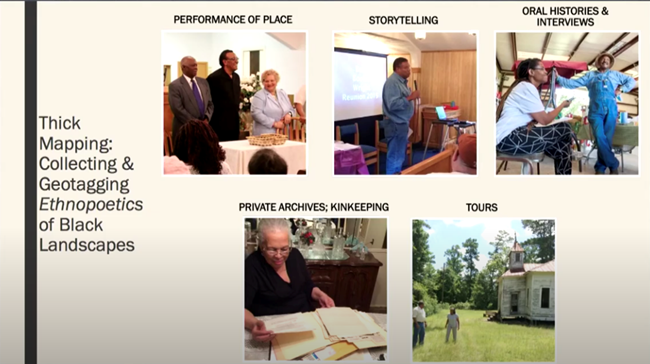
We're committed to preservation, education, service, and the transformation of the relationship between preservation and planning professionals and these communities. We record and analyze placemaking stories. We've built a secure Atlas and database of the locations, the known locations of these places. And we've developed an evidence-based community resilience strategies program where we engage in research and seek solutions in partnership with communities. But goal two is what I'll speak about mostly today, and about our approach to developing this Atlas and this way of documenting place.
And so, as I mentioned before, 2014 this started as part of my doctoral research. But it really has continued to inform our ways of understanding and listening to descendants of these places, characterize the nature of the landscapes and the relationship to them. And it really involves everything you see here, the storytelling, the interviewing, the walking tours, the private archives.

Dr. Andrea Roberts, Texas A&M University
However, much of what we've been able to do is, because I have geotagged and trained others to geotag, that is to affix locations to each of these items, and to any tours and walking and any of the experiences I have in these places.
So, what's the tangible result of that? Well, the tangible result was first revealed in the regional mapping I did in Newton and Jasper Counties. So over a year and a half period, the original Thad Sitton and Joseph Conrad book has a list of places, and it tells us that there are 14 places in these two counties. And afterward, after all of the research and the interviews, there's some 35. So upon noting that gap, I thought about how it is that we can roll this out considering we have a list of 557 places. So it wasn't practical to say, well great, I'll just do the same ethnographic process one by one by one.
But instead this Atlas was an approach that was a way to think about how do we capture the diaspora and connect the diaspora of these places back to these places and have a safe space for holding it? How do we connect the counter narratives of these places to the counter maps or the Atlas? And the rationale is that we do much of what Perky talked about, the same types of materials, but our method is very much about action research and centering the descendant rather than just engaging them. But really looking at the ways they're already recording these histories.
And so that brings me to sharing with you our Atlas and Survey. This online tool has actually been in existence since 2018. It originated with the list that I mentioned before, but also contains all of the sources you see there, including a lot of the already publicly available sources.

Dr. Andrea Roberts, Texas A&M University
We've mapped 357 of the 557 we have on our list, and we also use surveys that capture more information than just stories. We capture information about the challenges, the problems, the best practices of descendants in these places.
And so, I'll just flip through these rather quickly. This is simply showing you that we have a number of layers in which you can see the spatial relationship between different challenges, census data, political jurisdictions, various ways of searching. This is an example of the screen where you would be able to go in and complete a short survey. You can upload pictures, images, stories, videos. You can add directly to the map if you don't want to add a long survey.
So, what's so fascinating, and I'm not going to read all of this to you, but these are the types of information we get; school locations, church locations, times in which the churches still convene. All of this essential data to really triangulate and prove up that this place existed.
So, what are we doing now? So when we say evolving initiative, I really mean evolving initiative. And so many people, I do have to acknowledge all the people in the room on this journey with me. I'm looking at so many people that I've known since 2011, 2012 when I just walked around with a list and an idea. And I'm just happy to see you all.
I thought it would be fun to actually let you know what it is that people upload. And what I find most notable about this example is that people upload, but the first thing they usually say is, "I'm not sure." Or "I don't know if I have the information." And this is what you get.
And so, we go from that to the regional mapping to the building the Atlas. And now we're in a new phase of engagement. And some of the things that we're doing are, doing a Freedom Colony Diaspora Storytelling Project with major museums in major cities to connect rural people and urban people to one another. We're doing a participatory cemetery assessment project that's made possible by the National Trust for Historic Preservation. A Texas A&M Law School partnership on webinars about laws that can help protect family-owned land and Freedom Colonies. And a lot of targeted action research over the next two to three years.
And so I share all of this with you, but I'm actually asking all of you to do a few things too. Contact us, ask us to come out and demonstrate, to coordinate events, to share what we're trying to do, to get involved. And contact us.
Thank you.
Texas A&M University
Speaker Biography
Dr. Andrea Roberts is Assistant Professor of Urban Planning, an Associate Director of the Center for Housing & Urban Development, and Fellow at the Center for Heritage Conservation at Texas A&M University. She is the founder of The Texas Freedom Colonies Project. She was an Emerging Scholar Fellow at the University of Texas at Austin's School of Architecture where she also earned a PhD. in community and regional planning and holds an M.S. in government administration from the University of Pennsylvania and a B.A. in political science from Vasser College.
Tags
- ncptt
- african-american heritage
- african american history
- black history month
- history
- cultural heritage
- cultural resources
- dr. andrea roberts
- texas cultural landscape symposium
- freedom colonies
- texas freedom colonies project
- atlas
- texas
- the great migration
- slavery
- jim crow
- vanishing treasures
- oral history
- kinkeeping
- storytelling
- oral histories
- performance of place
- survey
- historic landscapes
- cultural landscapes
