Last updated: May 30, 2024
Article
The Camposanto at Mission San José
By Cristóbal López
One of the many characteristics and customs of Spanish Missions along the borderlands was the establishment of a camposanto (sacred burial ground) for baptized Native Americans and citizens of New Spain. Generally, Spanish missionaries established camposantos in front of the church or as near to the front of the church as possible. Today, there are two grave markers in a small camposanto located in front of the church at Mission San José.
Were these graves part of a larger cemetery? What is the history of the Mission San José camposanto?
The following decade, Jacinto Barrios Y Jauregui provided a detailed report of the structural and social conditions at Mission San José. In his 1758 report, Gov. Barrios noted that “the said reverend father likewise showed me three folio books for this mission from which it is evident that 964 persons have been baptized, 145 couples have been married according to the laws of the Church, and 466 deceased persons have received Christian burial.”3 Gov. Barrios was also the first to provide a detailed description of a cemetery's location at Mission San José. He noted that in the space between the church and soldiers’ quarters was “the cemetery which is more than 80 varas (222 feet, 4 inches) square and is surrounded by a rubblework fence having three entrances,” which served “as the military plaza. Here the natives have their gun and arrow practice and their drills.”4 (Figure 1)

Exhibit F, page 2-5, Juarez and Juarez Mission San Jose Cultural Landscape Report 1995.

Exhibit I, page 2-19, Juarez and Juarez Mission San Jose Cultural Landscape Report 1995.

Photograph courtesy of the University of Texas at San Antonio Special Collections.
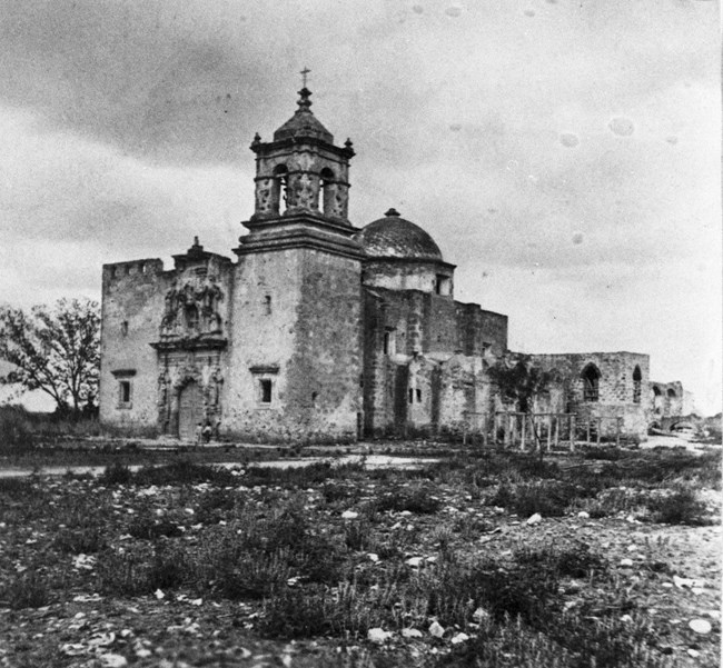
Since there are no remnants of the cemetery that Barrios described in his report, we cannot definitively pinpoint the exact location of where burials occurred. However, his report, along with various source material, provided us with a general location of where the cemetery might have been. As described in his report, the cemetery was located between the soldiers’ quarters and church, which measured 222 feet on a side. The distance from the church's southern wall – the wall where the Rose Window is located and what would have been the front of the church before the 1760s – to the ruins found on the southeast section of the plaza measured 280 feet. That distance allowed for a cemetery and plaza, as described by Barrios. 8
Even if this area served as the cemetery, we do not know if most burials took place in the entire plaza, remained close to the front of the church, or inside of the church. In his report, Barrios specifically stated that the 466 people buried at Mission San José received a “sepultura eclesiástica” or an ecclesiastical burial. Therefore, it is likely that most burials at Mission San José occurred on consecrated ground, either being within the church structure or in a camposanto located in front of the church before the construction of the new church during the 1760s.
The last reference of the cemetery’s location during the colonial era appeared in Antonio Huizar’s grant of the granary and land at Mission San José in 1815. When describing the measurements of the plot of land being granted to Huizar, José Antonio Bustillos noted that “the house has 40 varas in frontage facing the East, and is bounded by the little plaza which is in front of the chapel cemetery and by the house of Damian Cordova.” 9 The “vara” was a common unit of measurement used by colonial Spain and Mexico. One vara roughly equaled 2 ¾ feet. Therefore, the description and area of the cemetery in Antonio Huizar’s grant suggests that burials were taking place in front of the new church, in the vicinity of where the two gravestones are today. No official Mission San José church records were kept following the secularization of the Spanish missions in 1824. However, that does not imply that that the community at Mission San José did not continue and burials ceased. The Camposanto (downtown San Antonio Cemetery) burial book from 1808-1865 recorded multiple Mission residents buried at Mission San José after secularization. However, the location of these burials is unknown. 10

Photograph courtesy of the Catholic Archives of Texas.

Photograph courtesy of the DeGolyer Library, Southern Methodist University.

Photograph courtesy of the DeGolyer Library, Sothern Methodist University.
Burials in front of the church likely ceased after attention to the restoration of Mission San José grew. It remains unclear what happened to the graves depicted in the photographs. There is no written record if reinternments occurred at separate cemeteries or if burials remained in front of the church. To this day only two grave markers remain, one belonging to Juan Huizar who passed away in 1893 and the other is illegible.
2 Toribio Urrutia, “Captain Urrutia of the Bexar Presidio, Reporting to the Viceroy, Praises the Padres for the Work done in all of the San Antonio Mission, December 17, 1740,” San José Papers Part 1, 1719-1791, San Antonio Missions National Historical Park Library: 80.
3 Jacinto Barrios y Jauregui, “Informe del Gobernador Sobre la Misión de San José, May 28, 1758,” San José Papers Part 1, 1719-1791, San Antonio Missions National Historical Park Library: 130.
4 Ibid, 132.
5 José de Solis, “Fr. Solis 1768 Report on Mission San José, March 191768,” San José Papers Part 1, 1719-1791, San Antonio Missions National Historical Park Library: 156-160.
6, 7, 11 Architects James and Juarez, San Antonio Missions Cultural Landscape Report, (U.S. Department of the Interior, National Park Service, Southwest System Support Office, 1998), 5
8 Ivey, Of Various Magnificence, 240-241.
9 “Grant of Land and Granary to José Antonio Huizar,” MR-70, Bexar County Spanish Archives, San Antonio, Texas.
10 John Ogden Leal, “Camposanto, an ancient burial ground of San Antonio, Texas 1808-1865 i.e.,1860,” FamilySearch, Last Modified 1975. https://www.familysearch.org/search/catalog/2060263.
