Last updated: November 10, 2020
Article
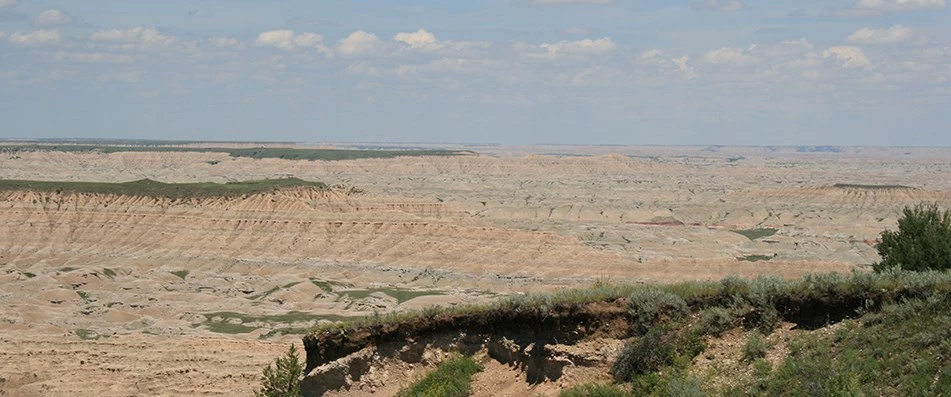
South Unit of Badlands National Park
NPS Photo

NPS Photo
History of the Unit
The South Unit of Badlands National Park holds some of the region's most valued natural resources. It contains spectacular scenery, including table mesas offering sweeping panoramas, deep canyons, washes, ravines, and foreboding walls. The large concentrations of mixed-grass prairies provide habitat for numerous wildlife species.
The South Unit is administered to provide for the care, maintenance, and preservation of historic, scientific, and scenic interest. Composed of two largely undeveloped and remote tracts of land, the South Unit offers an experience rich in the history and culture of the Lakota people and the natural heritage and scenery of the White River Badlands.
The South Unit is a landscape of great historical and spiritual significance to the Oglala Lakota. The South Unit is located within the Pine Ridge Indian Reservation as established in 1889. In 1942, the War Department took 341,725 acres from the Pine Ridge Indian Reservation to establish the Aerial Gunnery Range (Bombing Range) for training purposes during World War II. Most of the South Unit is located within the former Bombing Range.
Individuals and families were forced to vacate the area on very short notice, and the value of the lands was at an all-time low as a result of the Depression. The acquisition of the Bombing Range increased competition for land in the area and inflated the price of replacement sites to the point that the relocated persons were not able to buy substitute land with the compensation they had been paid. In many cases, individuals were forced to dispose of their livestock because their rangeland had been taken. The lands were acquired through declarations of taking filed in condemnation proceedings under the pressures of a wartime emergency. There is evidence that many of the Tribal members were told they would be given preferential status to repurchase their lands at the end of the war.

Oglala Lakota Tribal Council
In 1968, all but 2,486 acres of the acquired lands were declared excess by the U.S. Department of the Air Force and was returned to OST. Several groups and organizations wanted part or all of this excess land. Many of the former owners, both Indian and non-Indian, wanted to repurchase the lands taken from them; the OST wanted to acquire all of the excess lands; the National Park Service wanted to include much of the land in an enlarged Badlands National Monument; the U.S. Fish and Wildlife Service wanted an area set aside for preservation of endangered wildlife; and the U.S. Air Force wanted to exchange some of the excess land for Tribal land it was leasing in its tactical bombing range.
Congress authorized a land swap between the Departments of Defense and Interior, creating the South Unit. The land exchange was subject to approval by the OST, but if the Tribe did not approve it, the lands previously held in individual trust would be disposed under surplus property procedures and permanently lost to the Tribe. Only by surrending management of the land to the NPS would the land be held in trust for the Tribe. In 1976, the Tribe granted an easement to the NPS to management the lands of the South Unit as part of Badlands National Park.
These overlapping agencies and groups, each with different objectives and missions, reveals the complications involved in managing the South Unit.
In 1976, the NPS and OST entered into a Memorandum of Agreement expanding the Badlands National Park by establishing the South Unit. The addition of the South Unit to Badlands National Park has been a contentious issue among the residents of Pine Ridge Indian Reservation since it occurred.

NPS Photo
White River Visitor Center
The White River Visitor Center is located 55 miles from the Ben Reifel Visitor Center, 20 miles south of Scenic on BIA 27. WRVC is a good point to begin an exploration of Pine Ridge Reservation. Exhibits on the history and culture of the Lakota people are available, as well as videos about Badlands National Park and the Lakota. WRVC provides drinking water and restrooms. All camping in the South Unit is backcountry in nature, and interested visitors are encouraged to consult with WRVC staff before any such trip. Gas and food can be purchased in the nearby towns of Scenic, Kyle, and Sharps Corner.
The White River Visitor Center operates on a seasonal basis, roughly Memorial Day until mid-October depending on staffing availabilities. Operating hours are 9am until 6pm and it is located about an hour drive south of the Ben Reifel Visitor Center. Rangers at the center can be contacted at (605) 455-2878. Daily ranger talks are offered, check in at the visitor center for more details. No reservations required.
The visitor center is housed in a double-wide trailer located at the southern end of the boundaries of Badlands National Park. It is the only facility with direct access to the White River. The future of the center remains in question as various proposals are envisioned for a new building contribution some aspect to the interpretation and developed of Lakota culture.