Last updated: April 13, 2022
Article
Water Quality Monitoring, 2021 Annual Update

Water quality is an important and sensitive indicator of aquatic and terrestrial ecosystem health. Monitoring river conditions helps scientists and park managers detect environmental patterns driven by human activity, climate change and watershed dynamics, then use that information to make better-informed decisions. The Southeast Alaska Inventory and Monitoring Network (SEAN) has prioritized continuous water quality monitoring in Glacier Bay National Park and Preserve, Sitka National Historical Park, and Klondike Gold Rush National Historical Park since 2010. Data collected thus far suggest good river health with rare, brief exceedances of Alaska Department of Environmental Conservation (ADEC) water quality standards. No exceedances occurred in 2021 at any SEAN river.
This research program (1) tracks hourly river conditions at a single site in each park from early spring to late fall, (2) examines seasonal and interannual variability, and (3) compares observations against state standards indicating optimal or hazardous conditions for fishes. Continuously collected data include:
- Water temperature (°C) reflects air temperature patterns and snow or glacial melt.
- Dissolved oxygen concentration (mg/L) quantifies microscopic oxygen bubbles essential to aquatic organisms. Mainly regulated by temperature, oxygen fluctuations can also be caused by enhanced biological respiration or decomposition, and water aeration.
- pH is a unit-less measure of hydrogen ion concentration indicating relative acidity or alkalinity. The chemistry of local rocks, soils, and rain impact observed pH levels.
- Specific conductance (mS/cm) describes the ability of water to conduct an electrical current. In Southeast Alaska, higher values represent groundwater influence and lower values rain and snow runoff.
- Turbidity (NTU) measures water clarity due to sediment load, which is strongly influenced by glacial runoff. This metric is tracked at Klondike Gold Rush National Historical Park only.
2021 Southeast Alaska Weather Conditions
A substantial winter snowpack (175% of the long-term median; Alaska Snow Survey) combined with summer temperatures 0.5-1°C warmer than usual (Alaska Climate Center) to yield significant melt-driven flooding. The Salmon, Taiya, and Indian Rivers all experienced record-setting high streamflows in 2021. An August atmospheric river and series of fall storms impacted the entire region.
Methods
During the ice-free season, water quality sondes sampled each river hourly at fixed locations. Once a month, park staff visited the site to check sensor calibrations, download data, and resolve any problems. Initial sonde deployment in Klondike was delayed until July due to staffing changes and river flooding. Dissolved oxygen sensor and central wiper issues at all parks resulted in data gaps. The SEAN’s certified annual water quality data are publicly available, as is the peer-reviewed protocol guiding this monitoring program.

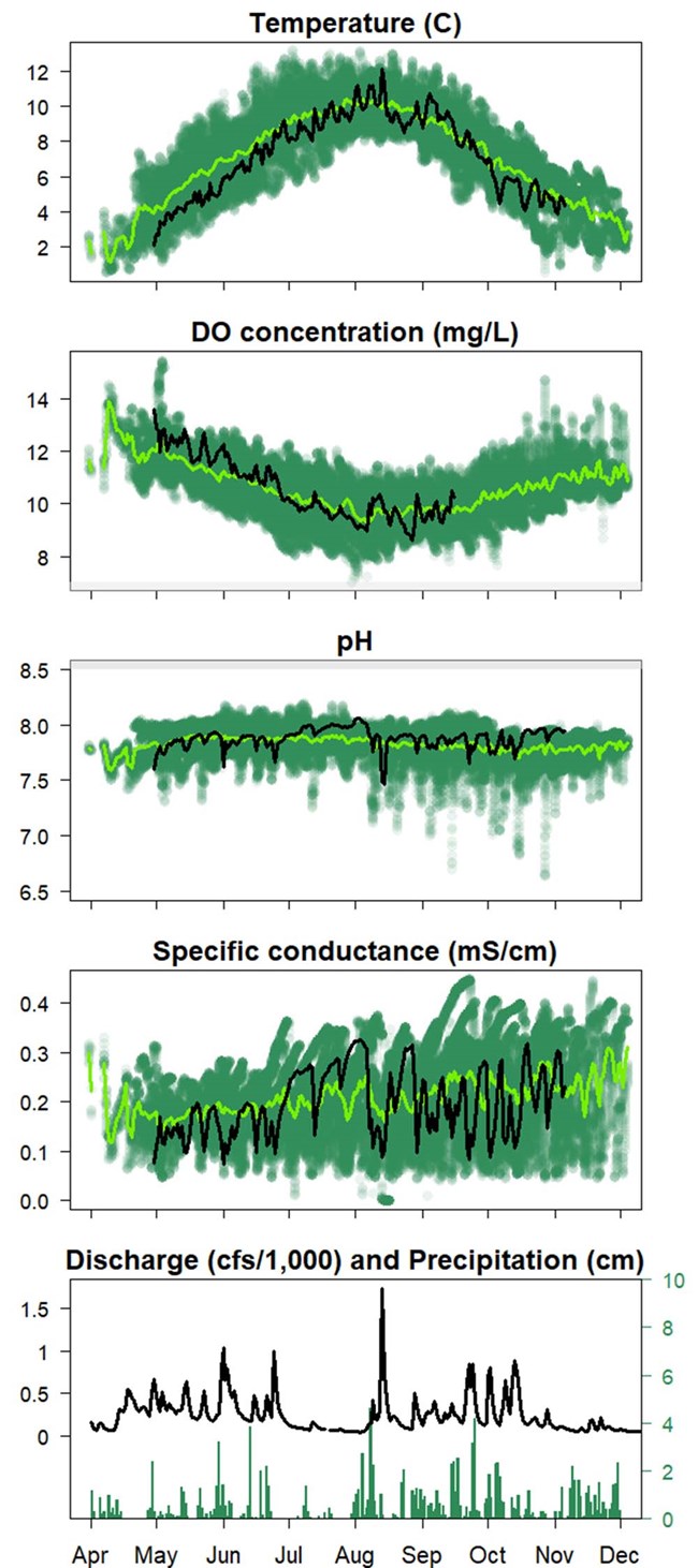
Shaded regions denote ADEC thresholds for unsuitable fish habitat for temperature (above 13°C), dissolved oxygen (below 7 mg/L), and pH (below 6.5 or above 8.5).
Glacier Bay National Park and Preserve
Glacier Bay National Park and Preserve has more than 300 streams flowing over 3,380 km through a diversity of glacially shaped landscapes. The SEAN monitors the Salmon River, whose watershed primarily drains Excursion Ridge to the east and features mature wetlands and forests. This system is strongly groundwater influenced, reflecting greater transport and storage capacity in wetlands and the local aquifer. The sonde is located at river km 9.0, just upstream from the park boundary (map). Since 2014, a U.S. Geological Survey (USGS) streamflow gage has operated about one km downstream from the monitoring site; no significant tributaries exist between the two stations.
The Salmon River is home to many productive anadromous fish populations. Although their life histories vary, especially with respect to spawning location and amount of time spent in the stream, all are vulnerable to environmental shifts due to climate processes. Tracking temporal changes in water temperature and flow patterns offers insight to these risks and is an established focus for Glacier Bay National Park and Preserve. 2021 April to November data are here compared to the 2010-2020 historical record.
2021 Observations
- Water temperatures were near normal throughout the sampling interval and followed the typical seasonal pattern. Peak summer conditions remained below the 13°C ADEC standard.
- Dissolved oxygen was above or near average during spring and summer, always above the ADEC threshold for anadromous fish (above 7 mg/L).
- pH values dropped slightly during storm events but were consistently well within ADEC optimums (between 6.5 and 8).
- Specific conductance fluctuations were driven by precipitation (low values) and stabilized during a mid-summer dry interval (high values, indicating greater groundwater influence).
- Discharge was well above normal during the spring and early fall. At the Salmon River gaging station, 2021 set record monthly mean discharge levels in April, May, and June, plus reached a record high for peak streamflow. Discharge peaks lag rainfall due to wetland storage.
| Parameter | Number of Readings |
Median | Mean | Standard Deviation |
Minimum | Maximum |
|---|---|---|---|---|---|---|
| Temperature (ºC) | 4,525 | 7.69 | 7.33 | 2.29 | 1.66 | 12.66 |
| DO concentration (mg/L) | 3,311 | 10.22 | 10.57 | 1.19 | 8.30 | 13.97 |
| pH | 4,520 | 7.89 | 7.88 | 0.11 | 6.93 | 8.26 |
| Specific conductance (mS/cm) | 4,521 | 0.19 | 0.20 | 0.07 | 0.05 | 0.33 |
| Discharge (NTU) | 4,501 | 214.00 | 279.79 | 229.68 | 48.80 | 1,730.00 |

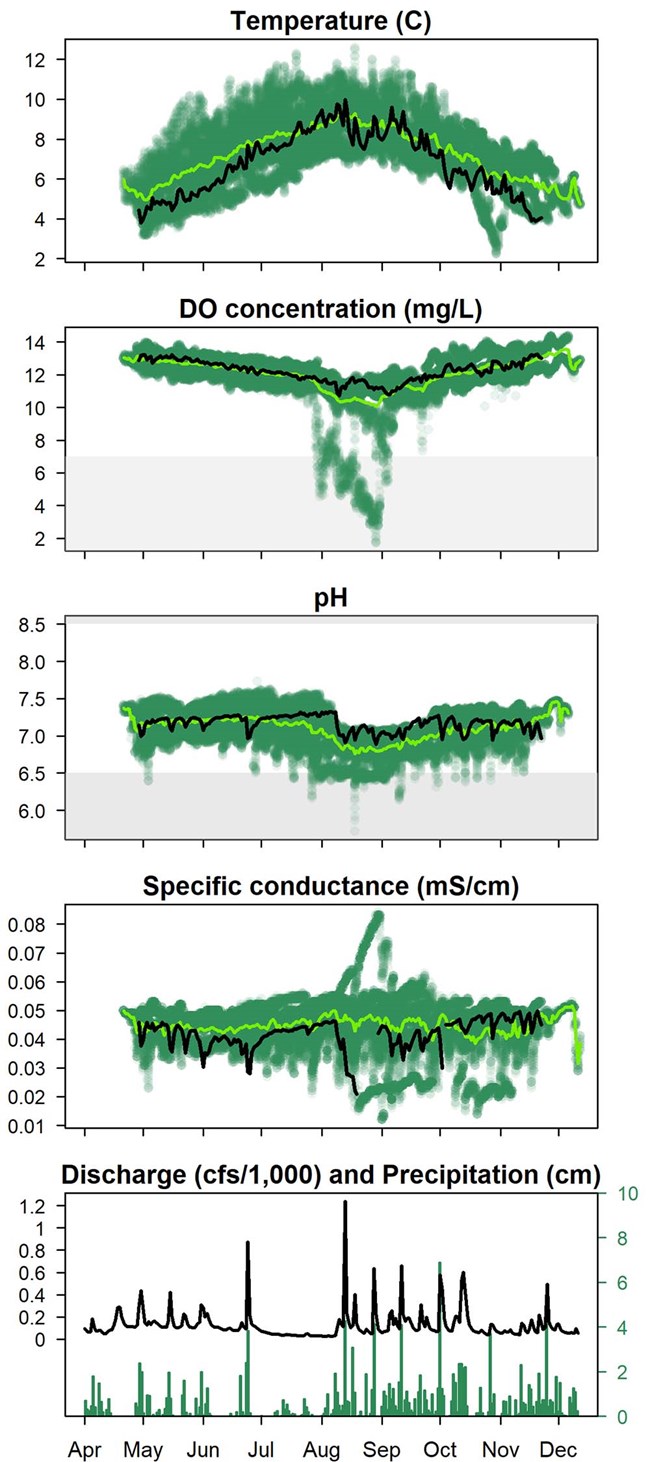
Shaded regions denote ADEC thresholds for unsuitable fish habitat for temperature (above 13°C), dissolved oxygen (below 7 mg/L), and pH (below 6.5 or above 8.5).
Klondike Gold Rush National Historical Park
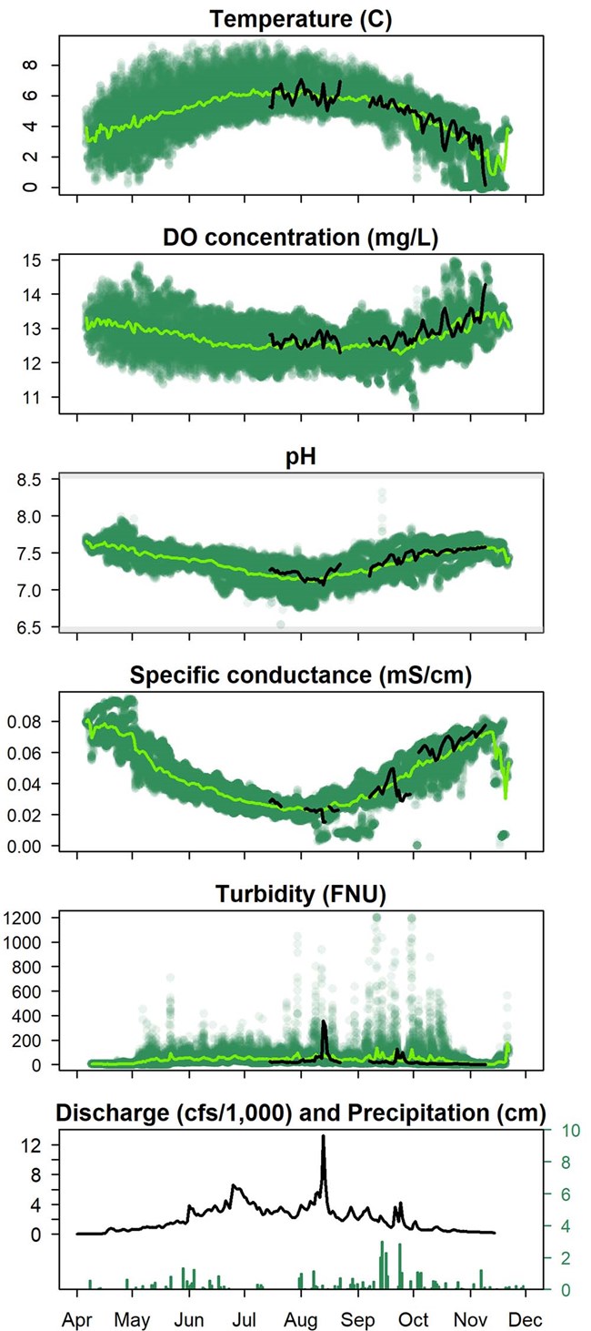
The Taiya River, located west of Skagway, is one of two major freshwater systems in Klondike Gold Rush National Historical Park. It drains a large mountainous watershed that was, as of 2010, approximately 29% covered by glaciers presently undergoing retreat. Glacial outburst events have caused large floods in the past and help shape this highly dynamic physical setting. The SEAN’s monitoring station is located near the Taiya River Bridge (map) adjacent to the long-established USGS streamflow gage. The Taiya watershed supports salmon populations as well as Dolly Varden and eulachon. Fish habitat conditions and turbidity fluctuations are particularly important to park natural resource managers. 2021 July to November data are here compared to the 2011-2020 historical record.
2021 Observations
- Water temperature in the glacially influenced Taiya River is less responsive to seasonal changes in air temperature than other sites. In 2021 data, temperatures were near normal with a sharp drop to the freezing point in November.
- Dissolved oxygen levels were slightly above average all months, with a fall increase driven by cooler temperatures.
- pH remained near normal for the entire season with minimal fluctuation.
- Specific conductance data gaps made discerning patterns difficult. Values were consistently within the historic range, dropping during an October storm and increasing to above average in late fall.
- Turbidity remained low; with sonde deployment delayed until July, the spring melt-driven sediment flush was not captured. The highest 2021 readings aligned with a mid-August warm weather interval with concurrent rainfall, snowmelt, and low-elevation flooding.
- Spring discharge increased gradually due to snowpack and glacial melt, reaching levels well above normal in June and July. In August, the Taiya River reached its highest recorded daily mean discharge and near record peak height during a short-lived flood event strongly driven by meltwater.
| Parameter | Number of Readings |
Median | Mean | Standard Deviation |
Minimum | Maximum |
|---|---|---|---|---|---|---|
| Temperature (ºC) | 2,432 | 5.18 | 4.96 | 1.36 | -0.07 | 9.14 |
| DO concentration (mg/L) | 2,432 | 12.80 | 12.83 | 0.37 | 11.79 | 14.39 |
| pH | 2,432 | 7.40 | 7.38 | 0.15 | 7.01 | 7.61 |
| Specific conductance (mS/cm) | 1,923 | 0.04 | 0.05 | 0.02 | 0.01 | 0.08 |
| Turbidity (NTU) | 2,427 | 16.80 | 28.25 | 56.83 | 1.80 | 835.90 |
| Discharge (cfs) | 2,432 | 1,700.00 | 2,053.11 | 1,912.38 | 210.00 | 13,200.00 |

Shaded regions denote ADEC thresholds for unsuitable fish habitat for temperature (above 13°C), dissolved oxygen (below 7 mg/L), and pH (below 6.5 or above 8.5).
Sitka National Historical Park
The Indian River provides the only significant freshwater habitat within Sitka National Historical Park. The 1-km section that flows through the park is a low gradient channel supporting a diversity of anadromous and non-anadromous fish. The quality of fish habitat, particularly during low flow and salmon spawning intervals, is a high resource management priority.
Draining a small, steep, and over 50% forested watershed, the Indian River is a mostly surface-water influenced system; discharge closely tracks precipitation events. Moderate development and human activity impact the lowest 2.5 km of the river. The National Park Service and City and Borough of Sitka collaboratively fund the USGS streamflow gage adjacent to the SEAN monitoring site (map), located just upstream of the park boundary. 2021 April to November data are here compared to the 2010-2020 historical record.
2021 Observations
- Water temperatures were below normal during spring and fall, though they reached typical levels by mid-summer. Overall, temperatures exhibited few sharp fluctuations over the sampling period.
- Dissolved oxygen was consistently near average and well above the ADEC threshold (7 mg/L) for optimal fish habitat all year. Cooler temperatures and abundant precipitation both contributed to observed oxygen conditions.
- pH readings remained near or above the long-term average, always within ADEC optimums (between 6.5 and 8).
- Specific conductance was below or near normal throughout the monitoring period. Distinct drops occurred with high rainfall and surface runoff; the lowest values were during the August atmospheric river.
- Discharge was well above normal all year except late July and early August. At the Indian River gaging station, 2021 set record monthly maximum discharge levels in April, May, and June, plus reached the site’s highest annual mean streamflow.
| Parameter | Number of Readings |
Median | Mean | Standard Deviation |
Minimum | Maximum |
|---|---|---|---|---|---|---|
| Temperature (ºC) | 4,977 | 6.82 | 6.79 | 1.62 | 3.47 | 11.73 |
| DO concentration (mg/L) | 4,976 | 12.24 | 12.20 | 0.63 | 9.92 | 13.40 |
| pH | 4,962 | 7.20 | 7.17 | 0.11 | 6.57 | 7.40 |
| Specific conductance (mS/cm) | 4,612 | 0.04 | 0.04 | 0.01 | 0.02 | 0.05 |
| Discharge (cfs) | 4,977 | 95.00 | 132.07 | 142.64 | 23.10 | 1,240.00 |
