Last updated: October 15, 2024
Article
Saving Precious Salt Marsh
The Inflation Reduction Act and Bipartisan Infrastructure Law bolster climate resilience at nine East Coast parks
By Bill O'Brian, October 2024
NPS / Cathy Johnson
Coastal marshes are important.
They provide nursery habitat for more than 75 percent of commercial fishery species, including shrimp, crabs, and many fin fish. They are vital to numerous, often rare or at-risk wildlife species, including the saltmarsh sparrow, a vulnerable bird whose population is in steep decline. They buffer communities from costly storm surges, flooding, and erosion. They capture atmospheric carbon with remarkable efficiency, thus mitigating climate change. They complement historically significant sites. They are peaceful places to paddle.
But they are disappearing. As a result of human development and sea-level rise, more than half of the original saltmarsh habitat in the United States has been lost. The problem is acute along the East Coast, where remaining marshes are especially vulnerable to future impacts.
With Inflation Reduction Act (IRA) and Bipartisan Infrastructure Law (BIL) funding, the National Park Service (NPS) is devising long-term plans to improve resilience of coastal marshes at nine East Coast parks.
“The overall project is focused on creating resilience in and around coastal marshes to conserve them and the ecosystem and socioeconomic benefits they provide to surrounding habitats and communities in the face of climate change and other impacts,” says Cathy Johnson, the NPS lead on the nine-park effort.
The project is in the planning stage. Johnson estimates it will take three to five years to complete, depending on the park.
The NPS is working with scientists and land managers from other conservation entities and academia to support marsh conservation on a wide scale. Together, they use predictive scientific models to guide how best to enhance resilience given projected sea-level rise rates.
Nature Has Been Disrupted
Salt marshes are flooded and drained twice daily by tides. In a healthy marsh, nature — left to its own devices — strikes the balance between too much and too little water. The challenge is that humans have disrupted that balance over the centuries by ditching marshes for agricultural or mosquito control purposes and, more recently, by extensively developing coastal areas.
The science is complex and the work painstaking, but the two basic ideas of this nine-park project are:
-
to promote natural water flow and sediment accretion (elevation buildup), thereby enabling marshes to restore themselves and stay ahead of sea-level rise.
-
to plan for inevitable sea-level-rise-related changes, including marsh migration (movement of marsh inland).

Google Earth
“A Lighter Touch”
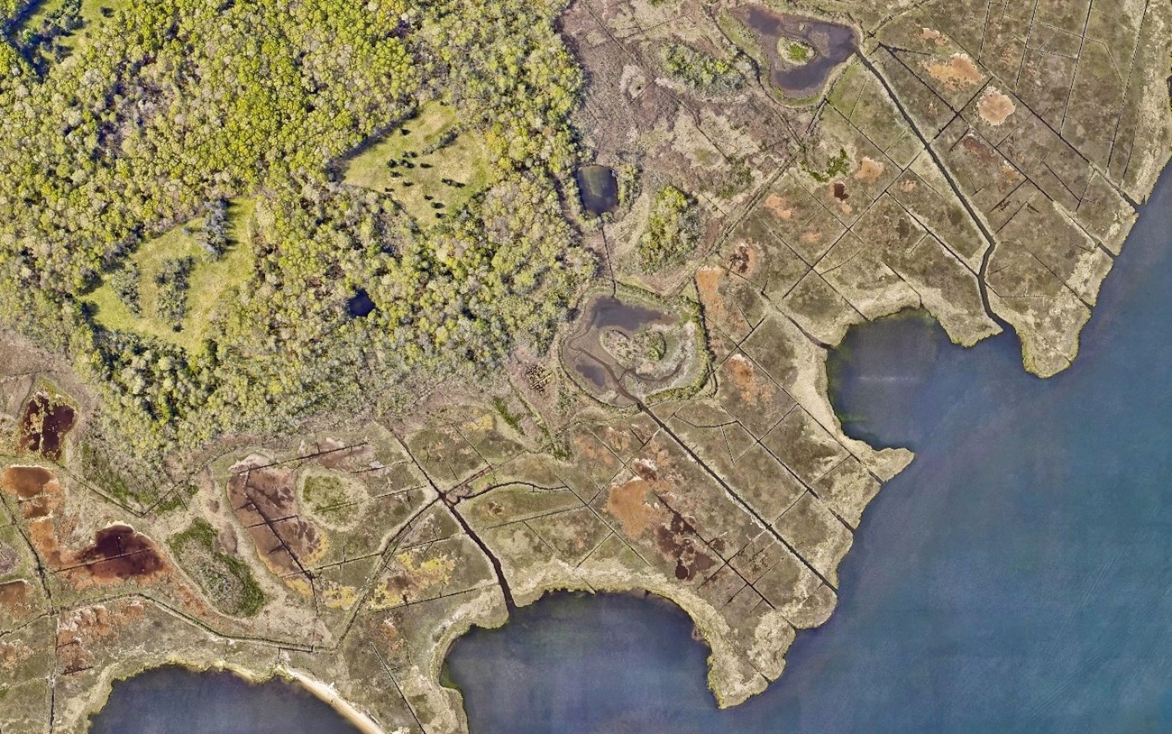
Fire Island National Seashore on Long Island, New York, is participating in the project.
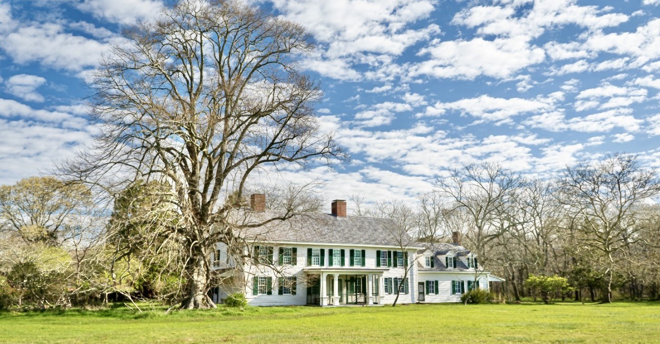
The focus at Fire Island is on salt marsh near the William Floyd Estate. The marsh is considered a cultural landscape because the estate pre-dates the American Revolution.
Many restoration projects involve heavy machinery spraying sand on marsh to elevate it in the face of sea-level rise. An approach developed by scientists and land managers in Salt Marsh Adaption & Resiliency Teams (SMARTeams) is “a lighter touch to the landscape compared to some of the other methodologies for saltmarsh restoration,” says Jordan Raphael, an NPS biologist who manages natural resources at Fire Island.
That approach involves placing salt hay (harvested from the marsh) in the deep ditches. Doing so traps material, starts the peat building process, and reestablishes vegetation. It also re-creates streamlets to restore natural tidal flow. No sand or other new material is brought in.
“We're really interested in this methodology, particularly at the William Floyd estate because of its cultural significance,” says Raphael. “This is using everything that's already in existence and sort of just moving some things around to help increase that water flow.”
Restoring the marsh is especially important because without restoration salt water will inundate — and start killing — a salt-intolerant oak-hickory forest that stands between the estate and the marsh.
Preserving and restoring salt marsh on Long Island is important to Raphael for another reason, too.
“I've got a young son. I stay up at night thinking about what the world's going to be like in 30 years, and I like to know that I'm trying to restore some of these areas so he can see and experience natural things like salt marshes,” Raphael says. “If we weren't doing this, 30 years from now it might not be there anymore.”
Saltmarsh Resilience at 8 Other East Coast Parks
IRA- and BIL-funded saltmarsh resilience projects also are underway at Cape Cod National Seashore, Massachusetts; Gateway National Recreation Area, New Jersey and New York; Assateague Island National Seashore, Maryland and Virginia; Colonial National Historical Park, Virginia; Acadia National Park, Maine; Harriet Tubman Underground Railroad National Historical Park, Maryland; George Washington Birthplace National Monument, Virginia; and Boston Harbor Islands National Recreation Area, Massachusetts.
Saltmarsh Conservation Partners
This nine-park saltmarsh resilience effort is supported by many partners, including: USGS Woods Hole Coastal and Marine Science Center; University of Rhode Island Coastal Resource Center and Environmental Data Center; Virginia Institute of Marine Science; Maryland Coastal Bays Program; Center for Coastal Studies and U.S. Fish and Wildlife Service.

NPS / Tyler Kuliberda

Bill O’Brian is a writing and editing partner with the National Park Service’s Natural Resource Stewardship & Science Directorate.
Tags
- acadia national park
- assateague island national seashore
- boston harbor islands national recreation area
- cape cod national seashore
- colonial national historical park
- fire island national seashore
- gateway national recreation area
- george washington birthplace national monument
- harriet tubman underground railroad national historical park
- ecosystem restoration
- climate resilience
- inflation reduction act
- bipartisan infrastructure law
- ecosystem
- cultural resource
- climate change
- saltmarsh restoration
- coastal parks
- northeast parks
- midatlantic parks
- smarteams
- william floyd estate
- outdoor recreation
