Last updated: January 5, 2022
Article
Quadrant

NPS / Michael David Brown
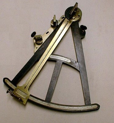
First used in the fifteenth century, the quadrant was the most popular navigational tool of the mid-eighteenth century. In order to determine his ship's position at sea, a sailor would use this instrument to measure the angle of the sun over the horizon at noon, and then use that measurement to calculate his vessel’s latitude. Celestial objects could be used to make similar calculations at night.
Navigators improved the quadrant throughout the eighteenth century, which made determining latitude at sea more simple and accurate than ever before. The quadrant is the ancestor of the more contemporary sextant, which is still used today by some nautical navigators.

NPS Photo
Quadrant, manufactured before 1800
Brass, Ivory, Ebony
SAMA 517
This quadrant was manufactured in the late eighteenth century by Spencer, Browning, & Rust, a London company that specialized in navigational instruments. It was a gift from the Bowden family of Marblehead and was used by a Mr. Bowden, a mate on U.S.S. Ino, during the American Civil War.
Ino was a speedy clipper ship, that assisted two other Union ships in blockading the famous Confederate vessel C.S.S. Sumter at the port of Gibraltar during the Civil War. The crewmen of Ino eventually captured two of Sumter’s sailors and sent them back to Boston as prisoners. The United States Navy continued to use Ino in blockades and cruises throughout the Civil War. Following the war, Ino was decommissioned.
|
“Physical Sciences Collections: Navigation,” Smithsonian National Museum of American History, Behring Center. Watts, Oswald M. The Sextant Simplified: A Practical Explanation of the Use of the Sextant at Sea. Thomas Reid Publications: London, 1973 |
