Last updated: April 7, 2025
Article
Podcast 080: Rapid Digital Documentation of Endangered Cultural Sites

CyArk
CyArk
Jason Church: Today I’m here at the Old Mint Museum in New Orleans, talking with Kacey Hadick the Manager of Heritage and Conservation Products with CyArk. So Kacey, tell us a little bit about who CyArk is?
Kacey Hadick: So CyArk is a 501C nonprofit based in Oakland, California. And our mission is to archive and share the world’s cultural heritage. So we’ve been around since 2003, documenting over 200 sites on all seven continents. I’m here talking about a kit that we created through a grant from NCPTT, how to rapidly document cultural heritage sites using photogrammetry.
Jason Church: Tell us a little bit about the kit? Why was it developed?
Kacey Hadick: Right now, as many people know, the Middle East is experiencing heritage loss, whether it’s in Iraq or Yemen or Syria. And so recognizing this need in these areas, it’s kind of difficult to use a laser scanner, which is one of CyArk’s traditional technologies. We wanted to create a kit that could be easily deployed and sent to these areas so locals on the ground could document their heritage using photogrammetry.
Jason Church: Now these locals on the ground, have they already been trained, or do they have knowledge of this, or is this something new for them?
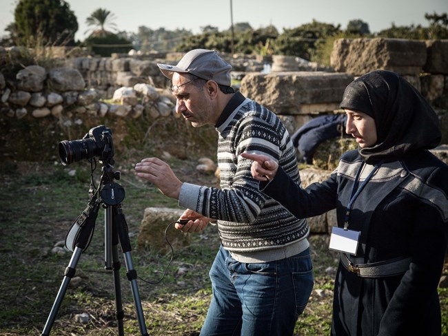
Kacey Hadick: So we’ve deployed three kits, the kit that’s currently being utilized in the Middle East was given to the UNESCO offices in Beirut, Lebanon. And in Lebanon we had teams from Lebanon as well as teams from Syria come and receive training on how to complete photogrammetry of heritage sites, so they do have some training.
Jason Church: So tell us a little bit, what is in this kit? What do they get?

Cyark
Rapid Digital Documentation Field Kit
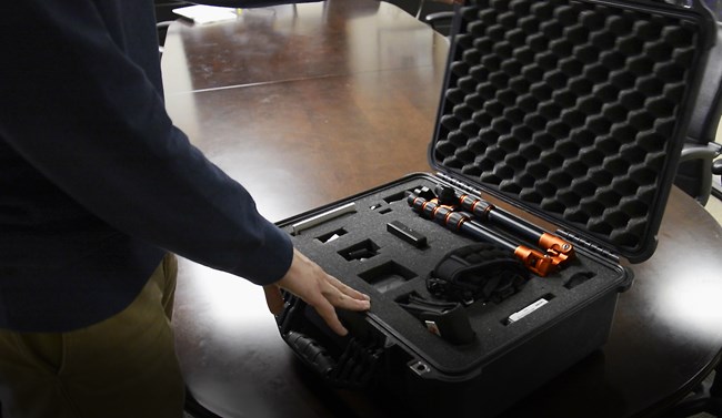
Kacey Hadick: The heritage documentation kit includes a digital camera, laser distance meter, a table computer, a GPS receiver and a compact tripod, as well as video tutorials, actually printed materials on best practices for how to document a heritage site. The kit is in English, the groups that we work with had some working knowledge of English, but it could be easily translated into Arabic or the language of the region. All of the materials that are within the kit are posted publicly online on the cyark.org website and you can select a checkbox and it will actually fill up your Amazon cart with all of the items within the kit. So the idea is that the materials in the kit, there’s nothing special that you have to special order, anything, this is all equipment that anyone can purchase and most people have some familiarity with digital cameras so that they can just begin documenting.
Jason Church: Once a kit’s been deployed, a team’s been trained, and they’ve gone out and they do the documentation, where does that documentation go?
Kacey Hadick: These are heritage organizations that we have deployed the kit to. And so it’s going back to their main offices where they can process the data. But there’s also an aspect where they store all of the data that they capture in the cloud and so associated with each kit is a Dropbox account so that the participants can upload their files that way, so that if the site is damaged and maybe their digital copies are lost, there’s still a copy in the cloud that’s safe
Internet Access via UNESCO
Jason Church: And what if they don’t have access to wireless or the cloud?
Kacey Hadick: They can move it to a different country. So in Syria, the internet is slow or spotty at times, and so what the participants have done is they’ve shipped actual hard drives containing the data that they captured to adjacent countries, in this case Lebanon, where we have a relationship with the UNESCO offices. And so in Lebanon at the UNESCO office, they upload the data to the cloud for us. The kit is currently being used in Damascus, Syria and in Aleppo. These are two regions that have experienced heavy fighting and both of the sites are UNESCO World Heritage properties and the UNESCO listing covers the whole entire old city, so there’s lots of historic buildings, from the 15th, 14th centuries. And so they’re documenting these structures with photogrammetry and uploading it to the cloud.

CyArk
So the initial project planned on six structures within Syria, but the idea is that they can take ownership and being documenting their own, and so that’s actually what they’ve done. So while Aleppo was not part of our initial project region, that area was recently recaptured by the government and so they have begun documenting the heritage there. So they have actually already gone beyond the scope of our initial project and are documenting heritage in the northern city of Aleppo.
Jason Church: Now we talked a lot about war torn areas, do you see this as a need in other areas as well?
Kacey Hadick: Definitely. The other two kits that CyArk produced were sent to the Center for Environmental Management of Military Lands, CEMML, as well as University of Colorado at Denver. And so we see a shift towards photogrammetry and the power that photogrammetric models have in heritage conservation programs as something really exciting, and we want to equip as many people as possible to use this technology.
CyArk is a small organization and the more people that are able to utilize these technologies, I think is better.
Jason Church: A small organization with a far reach.
Kacey Hadick: Yeah, it’s exciting. And again, like I said everything is online for people to purchase their own kits or learn about our documentation methods.
Jason Church: When they go out to document a site, are the groups then doing the 3D modeling and the photogrammetry or are they just capturing the data and sending it to someone else who will process it?
Kacey Hadick: So in the case of the Syrian heritage professionals, they are documenting it themselves, and then since we are getting the data back, we also create the models from the point clouds and so we can compare them to make sure that the quality’s as high as possible.
So this kit, if you could click through your Amazon cart today, it would cost less than $1500. Pretty exciting, what’s possible. As we learned today at the Mint, you can do photogrammetry with your phone. And so the quality is not going to be as great as you’re going to get with a digital SLR camera but for creating a model for interpretation uses that are maybe not for conservation but for posing on the web, you can use your simple cell phone camera.
Jason Church: Tell us about what CyArk ‘s got coming down the line?
Photogrammetry for Heritage Conservation

CyArk
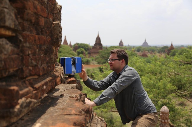
Kacey Hadick: So, CyArk is currently in Bagan, Myanmar, which is an archeological area located within the center of the country, and it’s called the land of 1,000 temples, and there’s actually over 3,000 Buddhist monuments within this valley. The majority of them were built in the 11th and 12th centuries and they’re built of un-reinforced brick masonry. And unfortunately, last year, the region experienced a pretty dramatic earthquake and over 300 of buildings were severely damaged. And so CyArk, this will be the third project that we do in Bagan. One expedition we completed before the earthquake and this will be the second following the earthquake, and so using our documentation strategies, which are laser scanning and terrestrial photogrammetry and drone photogrammetry, we’re creating conservation products for the government of Myanmar and the UNESCO regional office, so they can complete conservation work and restore the temples.
Currently, the government of Myanmar is proposing the site as a UNESCO World Heritage List and so all this documentation is going into their proposal. We got lucky this time that we had gone before the earthquake and so we could actually mesh the models before, and then mesh them following the earthquake and compare the two models to see where the building has been affected by the earthquake. So maybe where arches are collapsed, or even many of the temples have detailed frescoes inside and so where they’re exfoliating off, we can compare orthographic images that were created from the model before and after the quake to see where areas were damaged.
Jason Church: So CyArk ‘s website, do you have any of the data archived?
Kacey Hadick: Yeah, so cyark.org is a great resource. There’s some data available online. So CyArk welcomes academic institutions and other organizations in requesting data that we may have captured in the past. Projects that we have completed and are available online can be downloaded in some limited degree. You can download completed models, or CyArk also has a sketch web channel where you can download OBJ’s of our models that we’ve produced for sites. We are currently working on opening up our archive even better, so we’re currently working with Yale on best practices on how to do this better. We’re looking to improve in this.
Jason Church: Well, it’s got to be a daunting task, I know that’s a lot of data.
Kacey Hadick: Yeah, since our founding in 2003, we’ve documented a lot of heritage sites and getting these files online in the most usable way has been a challenge, and we’re working on the best ways to do this.
Jason Church: Well, we look forward to hearing more about the projects CyArk are doing.
Kacey Hadick: Great. Yeah, we’re extremely grateful and we know that Middle Eastern heritage professionals were grateful for receiving the kit and other groups, and it’s been a great project. Great collaboration.
Jason Church: Well, good. Maybe then at next podcast that we do with you can be from another grant.
Kacey Hadick: Sounds great, sounds wonderful. Hopefully.
Jason Church: Thanks for talking to us today Kacey.
Kacey Hadick: Thank you.
Read other Preservation Technology Podcast articles or learn more about the National Center for Preservation Technology and Training.
