Article

MRDAM Field Research


Fieldwork was conducted in 2019 by a team of two archeologists, Tad Britt and Sam Huey, geomorphologist Dr. Kory Konsoer, and students Macy Linton, Jon Oliver, and Sumaiya Siddique. The team visited 21 archeological sites. At many of the sites that were not yet underwater, the team found shells, ceramics, and stone tools. Erosion and sea level rise were noted at all sites. The geomorphologist used a drone to collect aerial photos, which were used to make geo-referenced images of the landscapes. Additionally, historic photos were compared to contemporary photos to see how the landscapes and archeological sites had changed over time. The photos were also used to measure land loss at each archeological site. This study is being used to make predictions about climate change, human activities, and their effects to cultural resources. In 2020, a geographic information system (GIS) database was developed to prioritize sites through which we can estimate and plan for the possible impacts from climate change and land alterations.
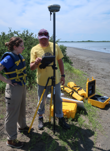
Two people staring at the screen display of a drone while the drone is operating on the beach of the marsh island.
Dr. Kory Konsoer and Macy Linton operate a drone.

National Park Service

Currently, MRDAM is continuing research through funding and a partnership with the U.S. Geological Survey South Central Climate Adaptation and Science Center (USGS South Central CASC). The funding was awarded in 2022 and the project will continue through 2024. This latest effort integrates community input with ethnographic, archeological, geomorphic, and climatic information, to inform future cultural resource management planning. Contact the Principal Investigator, Dr. Kory Konsoer, LSU, or visit the South Central CASC’s web page to learn more information.

_

Contact Us

Please send us an email if you have more questions about MRDAM.
MRDAM Contact Email.

Last updated: July 27, 2023