Part of a series of articles titled Whitebark Pine Monitoring in the Greater Yellowstone Ecosystem.
Article
Methods for the Interagency Whitebark Pine Monitoring Program in the Greater Yellowstone Ecosystem
This is the fifth article in the article series, Whitebark Pine Monitoring in the Greater Yellowstone Ecosystem.
This article summarizes the methods used by NPS Greater Yellowstone Inventory and Monitoring Network crews to track whitebark pine (Pinus albicaulis) health in the Greater Yellowstone Ecosystem (GYE). It is part of the article series, Whitebark Pine Monitoring in the Greater Yellowstone Ecosystem. Details of the sampling design and field methodology can be found by downloading the Interagency Whitebark Pine Monitoring Protocol for the Greater Yellowstone Ecosystem Version 1.1 (GYWPMWG 2011).
Study Area—The Greater Yellowstone Ecosystem
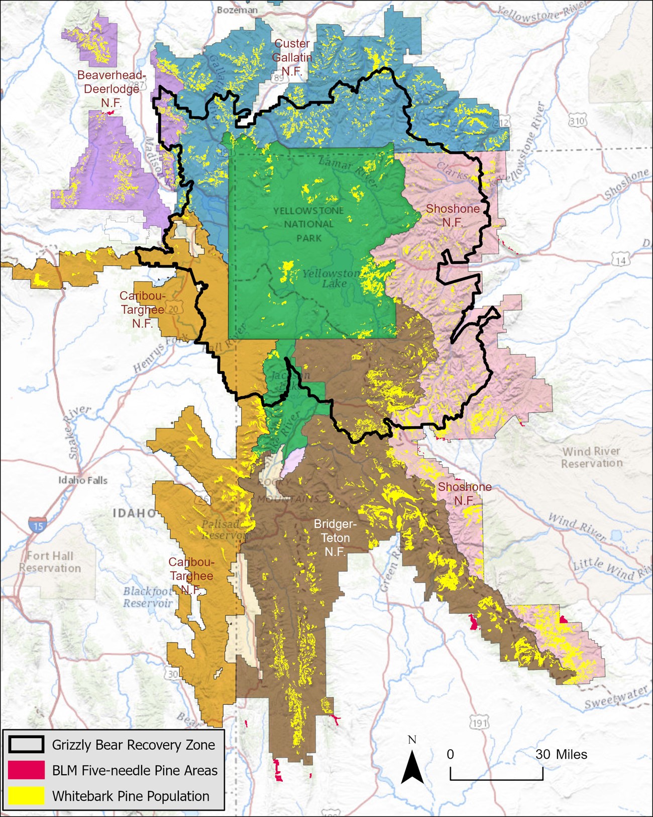
The GYE study area is geographically defined as the Yellowstone Plateau volcanic fields and the 14 surrounding mountain ranges (Marston and Anderson 1991). This area includes five national forests, three national parks, and Bureau of Land Management lands (Figure 1). Iconic Yellowstone and Grand Teton national parks (John D. Rockefeller Jr. Memorial Parkway is administered by Grand Teton National Park) are located at the center of this ecologically diverse region. The national forests are the Beaverhead-Deerlodge National Forest (MT), the Bridger-Teton National Forest (WY), the Custer Gallatin National Forest (MT), the Shoshone National Forest (WY), and the Caribou-Targhee National Forest (ID, WY).
NPS
Sample Frame
Whitebark pine, in mixed and dominant stands, occurs in over 2.5 million acres of the 15 million+ acres of the GYE. The target population for this program is all whitebark pine trees found on NPS and US Forest Service lands in the GYE. The sample frame included stands of whitebark pine approximately 2.0 hectares (5 acres) or greater within and outside of the US Fish and Wildlife Service grizzly bear recovery zone (RZ). Whitebark pine stands were defined as a contiguous area of forest with whitebark pine as the dominant or codominant component. Stands were identified using photo-interpretation (Dixon 1997) and stand composition cover maps (GYWPMWG 2011). At the inception of the monitoring program in 2004, a total of 10,770 whitebark pine timber stand polygons were identified in the mapping process, with 2,362 located within the RZ and 8,408 located outside of the RZ. Stands within the RZ were derived from the cumulative effects model for grizzly bears, while outside the RZ, the sample frame included whitebark stands mapped by each of the five US Forest Service units (Dixon 1997; pers. comm. with L. Landenburger, Grizzly Bear GIS Database Coordinator, 2012). Areas that burned after 1970 were excluded from the sample frame.
In addition to the whitebark pine population sampled since 2004 on NPS and US Forest Service lands in the GYE, several additional five-needle pine timber stands have been sampled since 2013 in areas administered by the Wyoming Bureau of Land Management (BLM) (Shanahan et al. 2022). In 2022, Montana BLM initiated a five-needle pine sampling program using the interagency whitebark pine monitoring program protocols (including the rapid assessment survey strategy). The BLM monitoring data are not included in this data summary, but they are available in the NPS.gov article series, “Five-Needle Pine Monitoring in Wyoming Bureau of Land Management Forests in the Greater Yellowstone Ecosystem,” as well as from Monitoring Five-Needle Pine on Bureau of Land Management Lands in Wyoming: Summary Report for 2013, 2014, 2016, 2017—republished (Shanahan et al. 2022), where detailed methods can also be found.
Sampling Design and Transect Establishment
The sampling design is a two-stage cluster design in which stands of whitebark pine are the primary units, and 10 meter wide by 50 meter long (10 × 50 m) transects within stands are the secondary units. The sample of transects is a probabilistic sample that provides statistical inference to the whitebark pine population in the Greater Yellowstone Ecosystem (GYE).
From 2004 to 2007, we established 176 permanent transects in 150 whitebark pine stands. All live, whitebark pine trees more than 1.4 meters (>1.4 m) tall (4,768 individual trees) located within the boundaries of transects were marked with a circular aluminum tree tag. Relocating and sampling each tagged tree every few years provides data useful for estimating changes in blister rust infection and survival rates over an extended period. Tree size (diameter at breast height in centimeters; DBH) was also recorded. We examined live trees for blister rust infection and recorded the location of blister rust infections (canopy or bole). A canopy canker was defined as any infection occurring within the branches of a tree ≥5 cm distal from the main bole. A bole canker was an infection on the main trunk of the tree or within 5 cm of the bole along branches. Bole cankers are considered more immediately lethal and therefore more severe than canopy cankers (McDonald and Hoff 2001; Schwandt and Kegley 2004).
Panel Assignment and Revisit Schedule
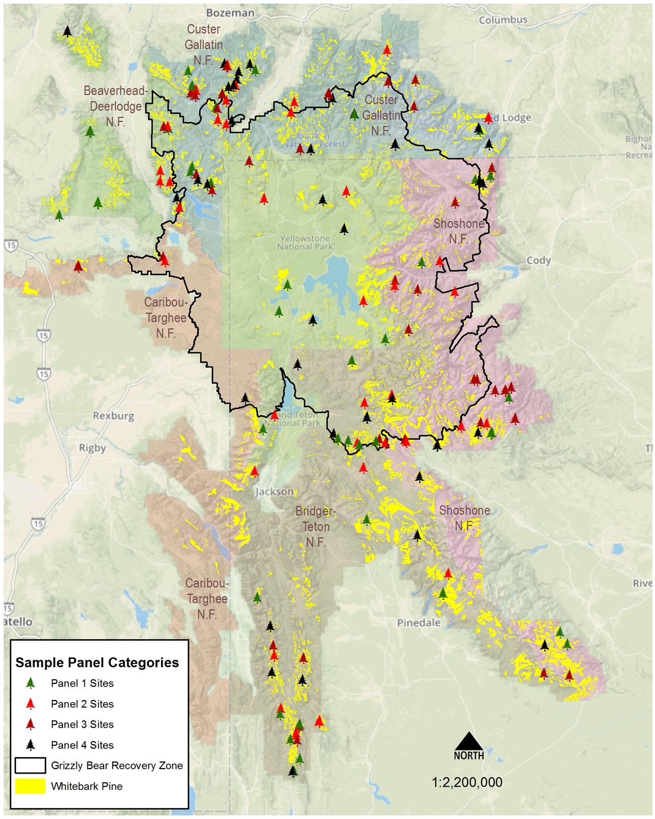
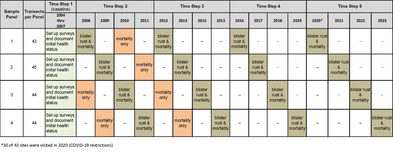
After 2007, stands were randomly assigned to one of four rotating panels. A panel is a grouping of about 44 permanent transects (Figures 2, 3). This is the number of transects that can be realistically visited in each field season by a two-person field crew. We conduct surveys from late June through mid-September each year, and each panel is revisited every four years. Four years is the approximate amount of time after initial infection with blister rust that visual signs become detectable (McDonald and Hoff 2001).
NPS
NPS
Time-Step Considerations for Whitebark Pine Health and Status
Status and trend assessments are more meaningful after many years of monitoring with comparable data accumulated over time (Witwicki 2012). For the whitebark pine monitoring program, more intensive evaluation of monitoring data is scheduled at four-year intervals after all 176 transects (divided into four annual panels) are resurveyed. Comparisons between years based on a single panel are misleading because each panel is composed of an entirely different set of transects. Data summaries from transects surveyed in any given year by panel do not reflect the entire sample of transects and therefore do not represent the estimated status or long-term trend of the overall GYE population of whitebark pine. The summary of data collected in a specific year should not be used to draw wide-reaching conclusions.
Objectives for Documenting Whitebark Pine Health
Objective 1: Estimate the proportion of whitebark pine trees >1.4 m tall infected with white pine blister rust, and estimate the rate at which infection of trees is changing over time.
Objective 2: Within infected transects, determine the relative severity of infection in whitebark pine trees >1.4 m tall (as indicated by aecia or canker location) and estimate the change in severity over time.
Objective 3: Estimate survival of individual whitebark pine trees >1.4 m tall, explicitly accounting for the effects of white pine blister rust infection, mountain pine beetle activity, and wildfire.
Objective 4: Document the recruitment of understory whitebark pine into the reproductive population and assess the multiple factors that influence regeneration and recruitment success over time.
All photos NPS/Shanahan, except swelling branch, by USFS/Hoff.
Objective 1—Blister Rust Infection Status
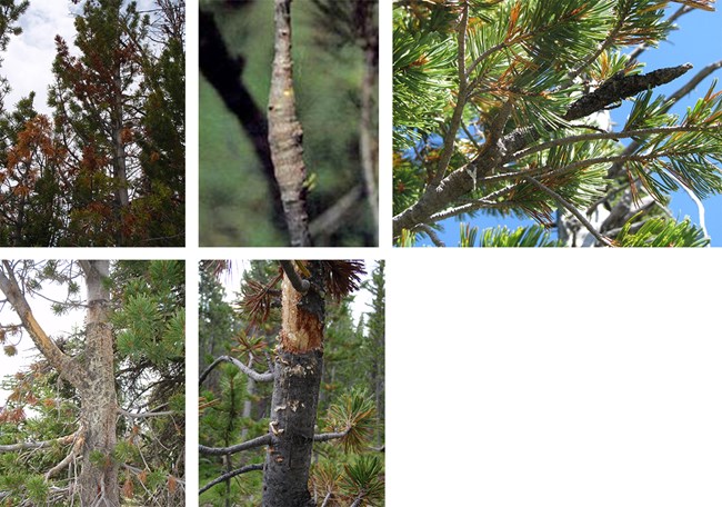
During a survey visit, the presence or absence of blister rust infection is recorded for all live trees on the 10 × 50 m belt transect. A tree is considered infected if either aecia or cankers are present. For a canker to be conclusively identified as resulting from blister rust, at least three of five ancillary indicators need to be present. Ancillary indicators of blister rust include flagging, rodent chewing, oozing sap, roughened bark, and swelling (Hoff 1992; Figure 4).

NPS

NPS/Shanahan
Objective 2—Blister Rust Infection Severity
To document the severity of infection, the location of a blister rust canker is recorded as occurring in the canopy (branches) or on the bole (trunk) of an infected tree. A canker located on a branch but within 5 cm or less from the bole of an infected tree is recorded as a bole canker. Bole cankers are more detrimental to the overall health of an infected tree and can be lethal by preventing essential nutrients from reaching sections of the tree above the infected area. Although a tree can persist for decades after becoming infected, cankers situated on the lower portions of the bole will eventually lead to tree death.
Change in infection severity is assessed following subsequent surveys of live, tagged trees. Infections that initiate in the canopy have the potential to spread to the bole of infected trees. However, trees can also self-prune branches (uninfected or infected), rodents can consume cankers entirely, and blister rust resistant trees can separate or wall off infected areas, which eventually scar over. Tracking infection location change through time can provide important insight into the potential health trajectory of individual, live tagged trees and possibly impart information on canker transition dynamics.
It should be noted that a 2017 statistical analysis of canker location data collected by multiple observers to investigate observer error indicated moderate to low agreement between observers on location assignment (bole or canopy; Wright and Irvine 2017). While this investigation revealed limitations in our ability to confidently report on location transition status, it did indicate a high degree of agreement in overall infection status among observers. Additionally, in 2020, only one observer collected infection data on all 30 transects surveyed. While this observer had over 20 years of experience identifying blister rust infection, observer subjectivity is always present regardless of the number of years of experience.

NPS
Objective 3—Mortality
For each tagged tree, observers identify if a tree is alive or dead. A tree with any green needles remaining on the tree is considered alive. Indicators of mortality influencing agents that may have impacted tree health are identified (i.e., mountain pine beetle, blister rust, animal damage, and mechanical damage such as windthrow, fire scar, and needle cast).
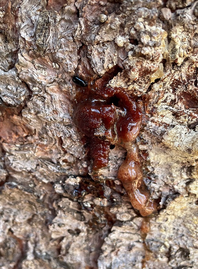
If mountain pine beetle activity is noted in live trees, observers record the type of indicator: pitch tubes and/or frass. Pitch tubes are small, popcorn-shaped resin masses produced by a tree to stave off a mountain pine beetle attack. Frass (boring sawdust) is created during a mountain pine beetle attack and can be found in bark crevices and around the base of an infested tree. For all dead trees (no green needles observed), a section of bark is removed to expose any J-shaped galleries that might be present. The presence of J-shaped galleries indicates that adult mountain pine beetles and their larvae occupied the tree.
NPS/Shanahan
Over the course of the mountain pine beetle epidemic (2008–2013), all transects were surveyed every two years to document mortality. Trees with all brown needles or devoid of needles were classified as dead in the year this was observed (any year from 2008 to 2013). After the peak of the mountain pine beetle epidemic, we returned to the four-year rotation of visiting the transects.

NPS/Shanahan
Objective 4—Recruitment
We base this assessment on three different indices of recruitment within the 10 × 50 m belt transects, as well as additional metrics collected within 1/300 acre recruitment subplots. The recruitment subplots overlap the beginning, center, and ending points of the belt transects. Note that several measurements include the term “five-needle pine” species. This generalization is due to the presence of limber pine (Pinus flexilis), another five-needle pine species found in the GYE. Without the presence of female or male cones on a tree, limber pine and whitebark pine are indistinguishable.
10 x 50 m Belt Transect
The three recruitment indices we measure within belt transects are
- The number of understory trees for any five-needle pine species <1.4 m tall (blister rust infection signs are noted). (Here "understory" refers to trees <1.4 m tall.)
- The number of whitebark pine trees (previously identified when <1.4 m tall), that grow to >1.4 m tall (blister rust infection signs are noted). These trees are tagged.
- The number of live, tagged whitebark pine trees, regardless of height, that show signs of reproductive activity (cones).
To approximate the average density of recruitment of five-needle pine trees per transect, we sum trees ≤1.4 m tall (within the 500 m2 transect area) across all transects sampled and divide by the total number of transects visited.
To investigate the proportion of reproducing whitebark pine trees, we conduct a visual assessment of all live, tagged whitebark pine trees on the transect for signs of current or past reproduction based on the presence of cones or cone scars. For reproducing trees, the cones are counted and categorized into five bins: 0 = no cones, 1 = 1–5 cones visible, 2 = 6–10 cones visible, 3 = >10 cones visible, and S = cone scars but no current year cones visible. To estimate the proportion of reproducing trees, we divide the total number of positively identified live, cone-bearing trees by the total number of live trees remaining in the tagged tree sample at the end of the revisit time-step.
Recruitment Subplots
To assess the influence of competition and other factors on whitebark pine regeneration and recruitment, we collect the following data in 1/300 acre (2.08 m radius) recruitment subplots associated with each belt transect:
- A count of all five-needle pine trees in four height categories (>0–15 cm, 15.1–61 cm, 61.1–140 cm, >140 cm; note that trees in the >140 cm category are tagged if they are within the 10 × 50 m transect boundary).
- A count of all trees by species, including lodgepole pines (Pinus contorta), fir (Abies lasiocarpa, Pseudotsuga menziesii), spruce (Picea engelmannii), and aspen (Populus tremuloides), in two height categories (15–140 cm, >140 cm).
- Bare ground cover and vegetation cover.
- Dominant and codominant vegetation species.
- Evidence of blister rust status on five-needle pines.
Circular recruitment subplots have a radius of 2.08 m and are associated with the beginning, center, and end monument points of each belt transect (Figure 5). Five-needle pine trees are examined and documented for blister rust infection based on the presence of aecia and other indicator criteria as described in the monitoring protocol. Recruitment subplot data are collected only when the entire 10 × 50 m belt transect is free of snow to ensure visibility of the small trees.

NPS
Trees Transitioning from the Understory
To document the transition of ≤1.4 m tall five-needle pine trees as they advance from the understory population into the sample frame of tagged trees (>1.4 m tall) in the established monitoring program, all trees 61.1–140 cm tall within the subplot boundaries are marked with a recruitment-specific tree tag, which is different than the tags used for trees >1.4 m tall. The distinct number on tagged understory trees is recorded by subplot location. Blister rust infection status and location (canopy/bole) is also documented, if present. Five-needle pine trees that grow above 1.4 m tall and occur within both a recruitment subplot and a 10 × 50 m monitoring transect are retagged for long-term monitoring.
Understory Species Composition and Ground Cover
To investigate competition among trees in the understory, all other conifer species, as well as aspen (Populus tremuloides), that are 15–140 cm tall within the subplot are tallied by species. Trees >1.4 m tall are also counted if at least half of the bole is located within the subplot.
Using Daubenmire cover class codes (Daubenmire 1959), the percentage of bare ground and understory vegetation cover is documented. The dominant or codominant vegetation species are noted.
Data Management and Analysis
Prior to analysis, all data are subjected to rigorous quality assurance and quality control (QA/QC) procedures as outlined in the protocol. Due to minor retroactive updates to the master database as part of ongoing quality controls, there may be an insignificant amount of variability (typically <1% difference) when comparing the current year’s data with data reported in previous years. All computational analyses and corresponding charts and graphs were produced using Microsoft Excel and the statistical computing language R (R Development Core Team 2019).
Data for all years are available from the NPS Integrated Resource Management Applications (IRMA) portal: Summary Data from Greater Yellowstone Ecosystem Interagency Whitebark Pine Long Term Monitoring Program.
Dixon, B. G. 1997. Cumulative effects modeling for grizzly bears in the Greater Yellowstone Ecosystem. Thesis. Montana State University, Bozeman.
Greater Yellowstone Whitebark Pine Monitoring Working Group (GYWPMWG). 2011. Interagency whitebark pine monitoring protocol for the Greater Yellowstone Ecosystem, version 1.1. Greater Yellowstone Coordinating Committee, Bozeman, Montana.
Hoff, R. J. 1992. How to recognize blister rust infection on whitebark pine. Research Note INT-406. USDA Forest Service, Intermountain Research Station, Ogden, Utah.
Marston, R. A., and J. E. Anderson. 1991. Watersheds and vegetation of the Greater Yellowstone Ecosystem. Conservation Biology 5(3):338–346.
McDonald, G. I., and R. J. Hoff. 2001. Blister rust: an introduced plague. Pages 193-220 in D. F. Tomback, S. F. Arno, and R. E. Keane, editors. Whitebark pine communities ecology and restoration. Island Press, Washington, DC.
R Development Core Team. 2019. R: A language and environment for statistical computing. R Foundation for Statistical Computing, Vienna, Austria. http://www.R-project.org/.
Schwandt, J. W., and S. Kegley. 2004. Mountain pine beetle, blister rust, and their interaction on whitebark pine at Trout Lake and Fisher Peak in northern Idaho from 2001–2003. R1-04-9. USDA Forest Service, Forest Health Protection, Missoula, Montana.
Shanahan, E., K. M. Irvine, K. Legg, S. Wilmoth, R. Daley, and J. Jackson. 2022. Monitoring five-needle pine on Bureau of Land Management lands in Wyoming: Summary report for 2013, 2014, 2016, 2017—republished. Natural Resource Report NPS/GRYN/NRR—2022/2412. National Park Service, Fort Collins, Colorado. https://doi.org/10.36967/nrr-2293294.
Witwicki, D. 2012. Integrated upland monitoring in Black Canyon of the Gunnison National Park and Curecanti National Recreation Area: annual report 2010 (non-sensitive version). Natural Resource Technical Report NPS/NCPN/NRTR—2012/542. National Park Service, Fort Collins, Colorado.
Wright, W. J., and K. M. Irvine. 2017. Assessment of imperfect detection of blister rust in whitebark pine within the Greater Yellowstone Ecosystem. Natural Resource Report NPS/GRYN/NRR—2017/1457. National Park Service, Fort Collins, Colorado.
Learn More
Find publications and an overview of whitebark pine monitoring on the Greater Yellowstone Network website.
Last updated: August 21, 2024
