Part of a series of articles titled Cultural Landscapes of Katmai National Park and Preserve.
Article
Brooks River Archeological District NHL Landscape
A Brief History
The Place
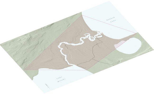
The Brooks River Archeological District National Historic Landmark is in the area immediately adjacent to and associated with the 1.5 mile long Brooks River, which connects Brooks and Naknek Lakes. The area, part of what is now Katmai National Park and Preserve, was formed by masses of moving glacial ice, gradually forming the present day interconnected system of glacially-carved lakes, rivers, and streams that ultimately empty into upper Bristol Bay. Volcanic activity has also played a major role in shaping the geology of the area, and layers of ash have blanketed the Brooks River area over a period of 4500 years.

NPS
The People
The Archeological District contains 21 sites that carry evidence of how people have hunted, fished, and gathered here for nearly 4500 years. Cultural remains and ethnographic reports document seasonal and and year-round human occupation of the area, influenced by important resources such as migrating land and marine mammals, spawning salmon, ripening berries, and plants. Different cultures used the Brooks River area at different time periods. As landscape conditions changed, long-standing lifeways adapted.
-
Focus on hunting migratory game
-
Temporary camps
-
Utilization of site by at least two different cultural groups prior to 1900 BCE
-
Part of a cultural tradition stretching across North America’s arctic coasts to Greenland
-
Unique to region:
-
A focus towards fishing
-
Constructed winter houses
-
-
A focus on fishing and hunting
-
Chipped chert and slate tools
-
Fiber-tempered ceramics
-
Coastal resource trade
-
Semi-subterranean houses with cold trap entries
-
Finely polished slate tools
-
Grit and sand temper ceramics
-
Bluffs phase: multi-room houses and incised pebbles

NPS / Alaska Regional Office
Significance and Condition
The Brooks River Archeological District is significant because it has yielded or
is likely to yield important data in the investigation of the 4500-year record
of Sugpiaq-Alutiiq and Yup’ik populations and their ancestors.
-
Period of Significance: 2500 BCE to 1912 CE
-
Significance Level: National
-
National Register Significance Criteria:
-
Criterion D: Archeology
-
-
Landscape Type: Historic Site
-
Condition: Fair— Cumulative impacts from historic and modern infrastructure, non-compliant projects, failing utilities, visitor impacts, cut-bank erosion and other natural processes may further degrade site integrity in the absence of proactive management.
Character Defining Features

NPS / Alaska Regional Office
Spatial Organization
Beach Ridges and River Terraces
Reveal past lake and river locations where traces of ancestral use are most often found.
An Orientation Towards the Water
-
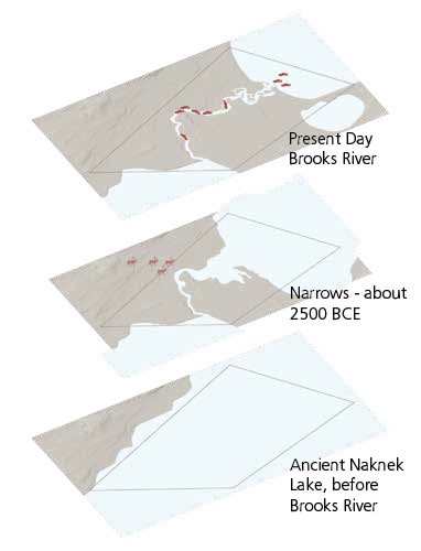
Fishing: Brooks Falls was exposed when lake levels dropped and provided an obstacle for migrating fish along with an opportunity for humans to harvest them.
-
Hunting: The narrows between Naknek Lake and Lake Brooks at about 2500 BCE create a short water crossing for migrating game and an advantageous location for hunting.
Topography
Over 900 surface depressions within the district represent human adaptation in seasonal mobility, cultural innovation, and social structure over several millennia. These remains of semi-subterranean houses (single-room and/or multi-room homes) with external storage pits contain cultural features like hearths, storage pits and house floors, and debris of terrestrial and marine animals.

NPS / Victor Cahalane
Information in the Landscape
The Brooks River Archeological District has already yielded important information about the region’s prehistory, and much more information remains in the land.
-
Sites: Archeological work since 1953 has identified 22 sites.
-
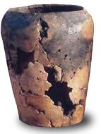
Excavations: Uncovered artifacts reveal information about the past.
-
Occupations: Multiple periods of use are often identified at the same location.
-
Ash Layers: Relative positions of ash deposits provide a timeline in the soil.
-
Testing: Carbon dating of organic remnants enable further refinements.
Last updated: November 21, 2023


