Last updated: January 23, 2023
Article
A Tapestry of Nations

Different tribes were connected by political alliances and trade, creating vast networks up and down the estuary and across the country. Life was not always peaceful, however. Inter-tribal conflict and raids were common. Conflicts had many motivations, ranging from ritualistic, retaliatory, demonstration, or territory acquisition.
By the late 1500s, some groups in the Chesapeake Bay developed a type of political system known as a “tributary network.” The chiefs of local tribes and towns would pay tribute to an overarching paramount chief. These tribute payments were made in the form of food and other items the tribe produced. The paramount chief had authority over tribes in his jurisdiction, though everyday governance was left to local leaders.
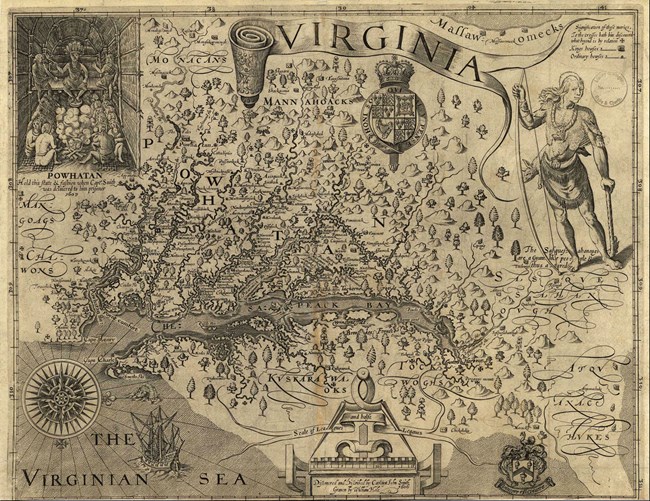
When the English began settling the Bay in the early 1600s, the political organization of the region was as follows:
The tribes of coastal Virginia from the James River in the south to the Potomac in the north were under the authority of the mamanatowick, or paramount chief. Chiefs of individual tribes and towns were called weroances (man) or weroansquas (woman). At the time of English arrival, the mamanatowick was Powhatan, the paramount chief who would be the first in the region to have political dealings with the Jamestown settlement. He lived at Werowocomoco, a significant town on the north bank of the York River. Today, tribes who were once a part of that political alliance are known as “Powhatan-descendent” tribes.
Paramount chiefs could be found on the Bay’s Eastern Shore as well. One example is the Kuskarawoak people. Today their descendants are the Nanticoke Indian Tribe. The Nanticoke were powerful traders, involved in the trade of shell beads and furs.
The groups mentioned above are Algonquian-speaking peoples. However, at the head of the Bay, two language families are represented: Algonquian and Iroquoian. The Algonquian-speaking peoples included tribes like the Tockwogh. The Iroquoian groups were the Massawomecks and the Susquehannocks.
The Massawomecks are thought to have lived far upriver somewhere on the Potomac. They frequently traveled downstream to raid Algonquian towns. The Susquehannocks were powerful traders, controlling the Susquehanna River that connected the Algonquian peoples of the Chesapeake to the Iroquoian peoples of the north.
On the north bank of the Potomac River was another tributary network, the Piscataway. Their paramount chief was known as the tayac. There were many densely populated towns in this region – perhaps a strategy to defend against raids from the Iroquoian-speaking Massawomecks and Susquehannocks to the north. Capital towns, like Moyaone and Accokeek, were fortified with walls.
