Holla Bend National Wildlife Refuge
Drops That Filled the River – Blood, Sweat, and the Trail of Tears. 824 words.
This graphic panel is mounted near the railing in the far corner of the covered pavilion as you come up the long ramp. As you face the panel, to your left you can see the oxbow lake which branches off the main river channel. A viewing scope sits near the railing on that side.
Text across the top of the panel reads, “Forced to Abandon the River. Low water levels in the rivers presented one of the biggest challenges on the Trail of Tears Water Route. Unlike today, there were no channels maintained for commerce. Shoals, sandbars, and snags were a daily problem. Yet changing to land travel presented its own challenges, like finding alternate transportation. The Drane and Whiteley detachments had to leave the river in this area and finish their journey to Indian Territory by land. They suffered in the oppressive summer heat, traveling partly at night to avoid the daytime misery.” End text.
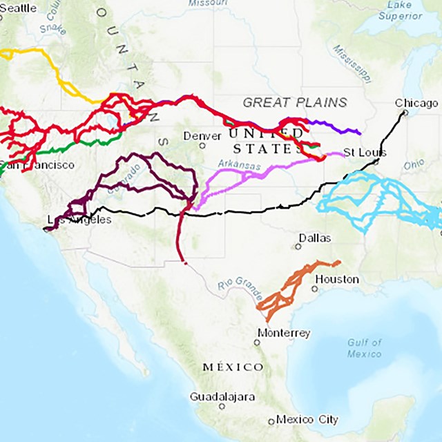
To the right of the text is a satellite image of this area with the main river channel between Lewisburg and Dardanelle traced in light blue. Near the bottom left a dotted white line traces the original river channel that formed an oxbow bend surrounding your current location on the eastern side. Across the top of the map is a yellow line that marks the path of the Land Route. The caption reads, “Today’s Holla Bend is bounded on one side by the Arkansas River and on its other sides by an oxbow lake that was formerly the main river channel. The river was straightened and channeled for flood protection in 1954. This far up the Arkansas River, sandbars, snags, or low water forced many detachments to end their Water Route journey and proceed to Indian Territory overland.”
The background of the panel is filled with a color illustration of three wagons alongside the river with a steamboat is docked. Two of the wagons are covered, while the one in the forground is being loaded by a man wearing a long tunic and feathers in his hair. Other people on the ground are moving bundles and crates. A captio at the right reads, “Groups of Cherokee going west were organized into detachments ranging from a few hundred to more than 1,000 people.”
More text at the left reads, “Whiteley Detachment. On July 13, 1838, the Tecumseh, carrying Lieutenant Robert Whiteley’s detachment of 740 Cherokee, got stuck on Bentley’s Bar, about four miles below Lewisburg. They camped near the town for six days while enough wagons were hired to finish the journey by land.”
“Drane Detachment. Captain Gustave Drane found his detachment aground one mile below Lewisburg, the steamboat and keelboats stranded in the river. Although they left with more than 1,000 people, by the time they arrived at Lewisburg only 660 remained. Over 400 disembarked in an attempt to lighten the load, but the steamboat could go no further. On August 13, 1838, they camped on shore, and within five days, Drane hired enough wagons to continue overland.”
“Black Seminoles Also Passed This Way. Whiteley’s detachment was joined by 33 Black Seminoles stranded in Little Rock who were separated from their party in New Orleans when some enslavers attempted to claim them as property. They camped with the Cherokee for five days.”
“Exhibit funded by a National Park Foundation Rivers and Trails grant.” End text.
On a dark band across the bottom of the panel more text reads, “Trail of Tears Water Route. 111 More Miles to Indian Territory. The United States government forcibly removed more than 16,000 Cherokee Nation citizens in 1838-1839 by land and water to Indian Territory (today’s Oklahoma). Other Native peoples removed from the southeastern US during the 1830s included 21,000 Muscogee, 9,000 Choctaw, 5,000 Chickasaw, and 4,000 Seminole. All who journeyed by water faced challenges and dangers, including the quick spread of sickness onboard, exposure to disease along the river lowlands, fires aboard steamers, unpredictable weather, and changing water levels that affected river navigation.”
At bottom right text reads, “Drops That Filled the River: Story and Itinerary. Travel the Arkansas River and follow the stories of the Trail of Tears Water Route. go.nps.gov/WaterRouteAR.” A QR code to the left of the text takes you to that web site.
Just to the right is the Audio Description icon with text that reads, "Listen, Learn and Follow the Trail. Audio description available. Learn more about this place and the Trail of Tears. go.nps.gov/HollaBend." There is also a QR code to take you to that web site.
Across the top of the panel is a black bar. At the left end text reads "Holla Bed National Wildlife Refuge." At the right end is the logo and text for Trail of Tears National Historic Trail. Other text reads, "US Fish and Wildlife Service, Trail of Tears Association, Arkansas Chapter, and National Park Foundation."
End of Description.