Last updated: August 31, 2021
Contact Us
Article
Fort Craig Exhibits Audio Description

BLM/NPS Exhibit
Fort Craig - The Royal Road Exhibit Audio Description
-
Fort Craig - The Royal Road Exhibit Audio Description
Listen to the audio description of the Fort Craig - The Royal Road exhibit.
- Date created:
- 08/31/2021
The Royal Road. 509 words.This panel is one of five that sit along a sidewalk at the side of the gravel drive. It is 3 feet wide by two feet tall, and sits 3 feet off the ground on two metal posts. That is approximately 1 meter wide by a half meter tall, and one meter off the ground.
The surrounding land is flat with various mountain features along the distant horizon. As you face the panels there is a closer peak that rises gradually at the left side and more steeply on the right. This is Fra Cristóbal Mountain. Another prominent feature is a wide flat-topped mesa to the left and slightly behind you, which is Mesa del Contadero.
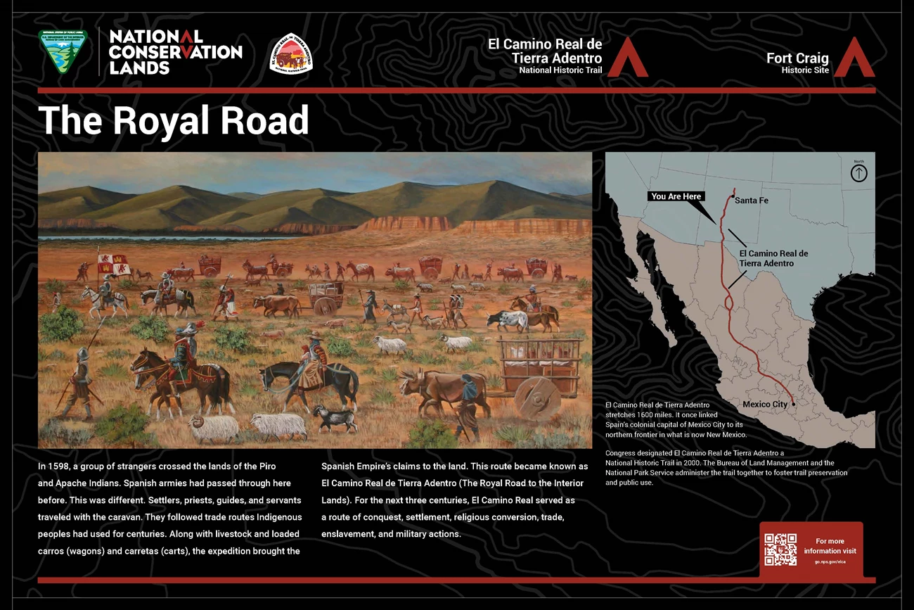
On the left side of this panel is a color illustration showing a view across scrub-dotted desert to mountains on the horizon. A river runs along the base of the mountain and several small mesas sit at right on the near side of the river. In the foreground are lines of people on horseback and on foot moving right to left. Some are dressed as soldiers with metal helmets. Others wear European clothing. Some wear native dress. Moving along with the people are wooden-wheeled carts pulled by pairs of oxen. There are also sheep and goats and some donkeys with packs on their backs. Text below the image reads, "In 1598, a group of strangers crossed the lands of the Piro and Apache Indians. Spanish armies had passed through here before. This was different. Settlers, priests, guides, and servants traveled with the caravan. They followed trade routes Indigenous peoples had used for centuries. Along with livestock and loaded carros (wagons) and carretas (carts), the expedition brought the Spanish Empire’s claims to the land. This route became known as El Camino Real de Tierra Adentro (The Royal Road to the Interior Lands). For the next three centuries, El Camino Real served as a route of conquest, settlement, religious conversion, trade, enslavement, and military actions."
On the right side of the panel is a map of the southwestern United States and Mexico. A red line labeled El Camino Real de Tierra Adentro runs from Mexico City in the south to Santa Fe in northern New Mexico. Your current location is marked in south-central New Mexico. Text below the map reads, "El Camino Real de Tierra Adentro stretches 1600 miles. It once linked Spain’s colonial capital of Mexico City to its northern frontier in what is now New Mexico. Congress designated El Camino Real de Tierra Adentro a National Historic Trail in 2000. The Bureau of Land Management and the National Park Service administer the trail together to foster trail preservation and public use."
Across the top are logos associated with various agencies. At left is the Bureau of Land Management, National Conservation Lands. Next is El Camino Real de Tierra Adentro National Historic Trail with an image of an ox-drawn cart. At the right are titles for El Camino Real de Tierra Adentro National Historic Trail and Fort Craig Historic Site. End of Description.

BLM/NPS Exhibit
Fort Craig - Guarding the Trail Exhibit Audio Description
-
Fort Craig - Guarding the Trail Exhibit Audio Description
Listen to the audio description Fort Craig - Guarding the Trail exhibit.
- Date created:
- 08/31/2021
Guarding the Trail. 636 words.This panel is one of five that sit along a sidewalk at the side of the gravel drive. It is 3 feet wide by two feet tall, and sits 3 feet off the ground on two metal posts. That is approximately 1 meter wide by a half meter tall, and one meter off the ground.
The surrounding land is flat with various mountain features along the distant horizon. As you face the panels there is a closer peak that rises gradually at the left side and more steeply on the right. This is Fra Cristóbal Mountain. Another prominent feature is a wide flat-topped mesa to the left and slightly behind you, which is Mesa del Contadero.
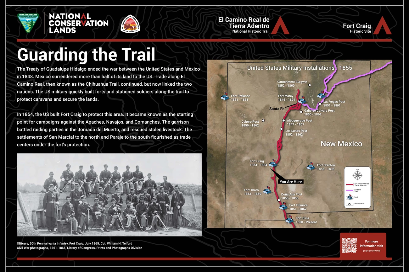
Text at upper left of this panel reads, "The Treaty of Guadalupe Hidalgo ended the war between the United States and Mexico in 1848. Mexico surrendered more than half of its land to the US. Trade along El Camino Real, then known as the Chihuahua Trail, continued, but now linked the two nations. The US military quickly built forts and stationed soldiers along the trail to protect caravans and secure the lands. In 1854, the US built Fort Craig to protect this area. It became known as the starting point for campaigns against the Apaches, Navajos, and Comanches. The garrison battled raiding parties in the Jornada del Muerto, and rescued stolen livestock. The settlements of San Marcial to the north and Paraje to the south flourished as trade centers under the fort’s protection."
At the bottom left is a historical photograph of three rows of men dressed in uniforms, some with double breasted jackets, others with single breasted. Each holds an unsheathed sword. The top row sits on an earthen rampart faced with planking. The bottom row sits on benches in front while the middle row stands in between. The caption reads, "Officers, 50th Pennsylvania Infantry, Fort Craig, July 1865. Colonel William H. Telford, Civil War photographs, 1861-1865, Library of Congress, Prints and Photographs Division."
On the right side of the panel is a map of New Mexico. A red line marks El Camino Real de Tierra Adentro extending up from the bottom to Santa Fe in the north central part of the state. Two pink lines mark the path of the Santa Fe Trail, coming in from the upper right, merging together and ending at Santa Fe. White dots for military posts and fort icons indicate the United States Military Installations of 1855. Beginning at the bottom of the map where the red line enters New Mexico is Fort Bliss, 1850 to the present. Just above that is Fort Fillmore, 1851-1862. Just above that is Doña Ana Post, 1855-1856. Above that and slightly to the left is Fort Thorn, 1853-1859. About a quarter of the way up the state is your current location at Fort Craig, 1854-1884. To the right of that, near the middle of the state is Fort Stanton, 1855-1896.Continuing upwards to just north of the center of the state is Los Lunas Post, 1852-1862 and above that is Albuquerque Post, 1847-1857. To the west of Albuquerque is Cubero Post, 1850-1862. At Santa Fe is Fort Marcy, 1846-1894 and just to the south is Galisteo Calvary Post, 1850-1862. West of Santa Fe on the state line is Fort Defiance, 1851-1861. A bit to the north of Santa Fe is Cantonment Burgwin, 1852-1860. East of Santa Fe, along the pink line is Las Vegas Post, 1851-1891.
Across the top are logos associated with various agencies. At left is the Bureau of Land Management, National Conservation Lands. Next is El Camino Real de Tierra Adentro National Historic Trail with an image of an ox-drawn cart. At the right are titles for El Camino Real de Tierra Adentro National Historic Trail and Fort Craig Historic Site.
End of Description.

BLM/NPS Exhibit
Fort Craig - Journey of the Dead Man Exhibit Audio Description
-
Fort Craig - Journey of the Dead Man Exhibit Audio Description
Listen to the audio description of the Fort Craig - Journey of the Dead Man exhibit.
- Date created:
- 08/31/2021
Journey of the Dead Man. 500 words.This panel is one of five that sit along a sidewalk at the side of the gravel drive. It is 3 feet wide by two feet tall, and sits 3 feet off the ground on two metal posts. That is approximately 1 meter wide by a half meter tall, and one meter off the ground.
The surrounding land is flat with various mountain features along the distant horizon. As you face the panels there is a closer peak that rises gradually at the left side and more steeply on the right. This is Fra Cristóbal Mountain. Another prominent feature is a wide flat-topped mesa to the left and slightly behind you, which is Mesa del Contadero.
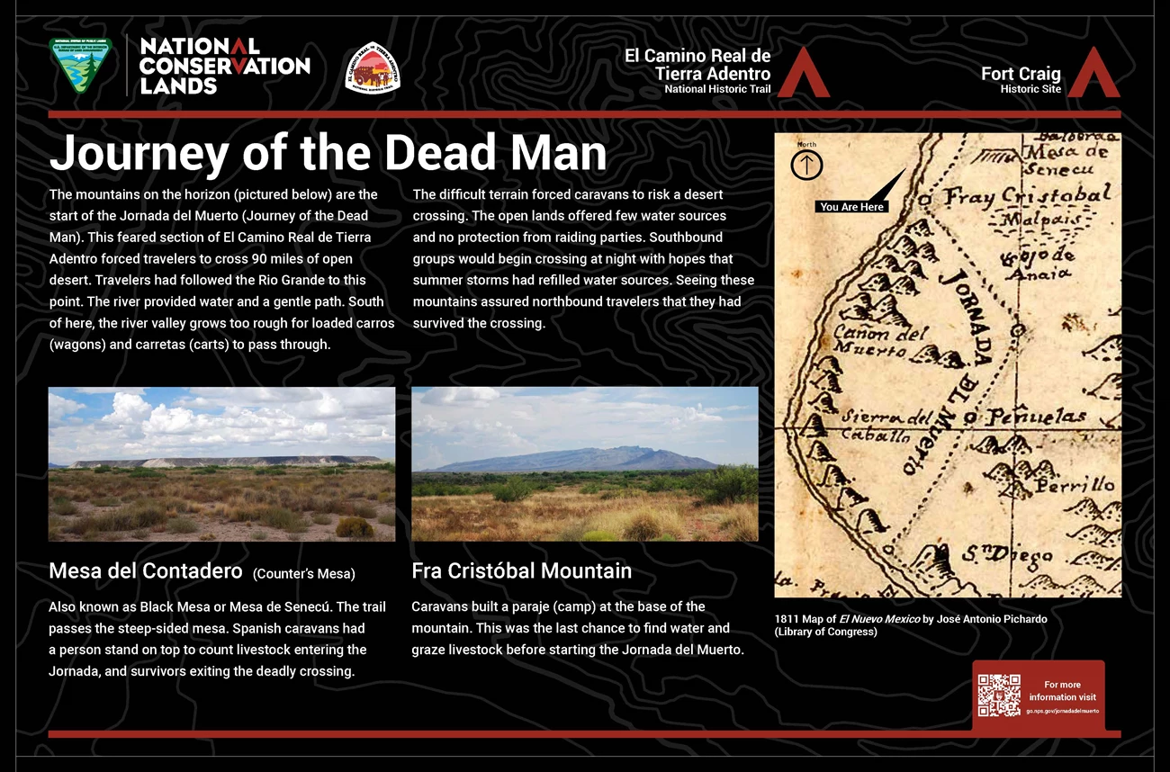
Text at the upper left on this panel reads, "The mountains on the horizon (pictured below) are the start of the Jornada del Muerto (Journey of the Dead Man). This feared section of El Camino Real de Tierra Adentro forced travelers to cross 90 miles of open desert. Travelers had followed the Rio Grande to this point. The river provided water and a gentle path. South of here, the river valley grows too rough for loaded carros (wagons) and carretas (carts) to pass through." “The difficult terrain forced caravans to risk a desert crossing. The open lands offered few water sources and no protection from raiding parties. Southbound groups would begin crossing at night with hopes that summer storms had refilled water sources. Seeing these mountains assured northbound travelers that they had survived the crossing.”
To the right of the text is an image of an 1811 Map of el Nuevo Mexico by José Antonio Pichardo from the Library of Congress. It shows the river winding down the left side in a wide curve with your current location being near the top of the map. Across the river and slightly below or south of your position is Fray Cristobal Mountian. Below that along the river is a series of small humps marking mountains. A dotted line follows the river down to Fray Cristobal then heads east, around the mountains and through a large open flat area, before turning downward to rejoin the river at the southern end of the map.
At lower left of the panel are two photographs. The one on the left shows a view across desert scrub to a wide mesa. The caption reads, "Mesa del Contadero (Counter's Mesa). Also known as Black Mesa or Mesa de Senecú. The trail passes the steep-sided mesa. Spanish caravans had a person stand on top to count livestock entering the Jornada, and survivors exiting the deadly crossing."
The photo on the right shows a low mountain with a gradual slope on the left and a steeper slope on the right. The caption reads, "Fra Cristóbal Mountain. Caravans built a paraje (camp) at the base of the mountain. This was the last chance to find water and graze livestock before starting the Jornada del Muerto."
Across the top are logos associated with various agencies. At left is the Bureau of Land Management, National Conservation Lands. Next is El Camino Real de Tierra Adentro National Historic Trail with an image of an ox-drawn cart. At the right are titles for El Camino Real de Tierra Adentro National Historic Trail and Fort Craig Historic Site.
End of Description.
