Last updated: January 18, 2023
Article
How vegetation has changed along subarctic river floodplains

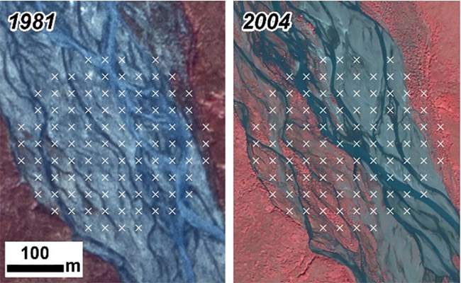
A study evaluating the patterns of vegetation change in riparian areas of Denali National Park and Preserve, Wrangell-St. Elias National Park and Preserve, and Yukon-Charley Rivers National Preserve was recently published in the journal Ecosphere. Using high-resolution aerial photography and satellite imagery, we compared patterns of vegetation in 12 streams across these parks from an initial period in the 1980s to early 2000s--a blink of an eye in ecological time.
We found a remarkable and consistent pattern of greening across the rivers studied, with the area occupied by rocky riverbed shrinking over the sample interval and vegetation coverage, density, and stature expanding. Given the ecologically vital role of riparian corridors in subarctic landscapes, our results reinforce important changes to the ecology and resources of these protected areas.
This publication represents the culmination of long-term observations, since 2005 or before, while we were working on a repeat photography project in Denali that revealed the (rather unexpected) insight that pairs of historic and modern photographs that included floodplains almost always showed an expansion of vegetation in the later image, and almost never revealed erosion or destruction of intact vegetation stands.
Dynamic disequilibrium: Recent widespread increases in vegetation cover on subarctic floodplains of Interior Alaska
Abstract
Boreal forest and tundra ecosystems are undergoing rapid climatic and environmental changes with consequences for ecosystem structure, function, and services. Although riparian zones occupy a small footprint within subarctic landscapes, they have disproportionately high value as foci of hydrological processes, biogeochemical cycling, ecological disturbance, biodiversity, and wildlife activity. Recent observations of increased winter discharge, reduced peak flows, and increased connectivity between catchments, streams, and groundwater in subarctic riparian zones have prompted predictions of altered riverine disturbance regimes, increased channelization, and a decline in the extent of active floodplains. However, few observational data exist concerning the spatiotemporal dynamics of subarctic floodplain vegetation, which can serve as a bioindicator to corroborate such predictions. We analyzed the distribution and extent of riparian ecotypes across a network of streams in 12 Interior Alaska watersheds using high-resolution image pairs from circa 1981–2010. All stream reaches encompassed pronounced elevational gradients and included elevational forest–tundra ecotones. We classified riparian ecotypes using an image-based point-intercept sampling approach, calculated the probability of ecotype transitions, and evaluated relationships between ecotype transitions and environmental covariates. Our results reveal widespread increases in the stature, density, and extent of riparian vegetation spanning gradients of elevation, floodplain morphology, and climate. Ecotype transitions occurred at >20% of sample points, and there was a strong imbalance toward forward successional transitions (16.5%) versus backward transitions (4.0%). That is, we observed a strong tendency toward increasing cover, stature, and density of vegetation communities across our extensive sampling domain across our approximately 30-year sample period. This relatively rapid riparian “greening” signal tended to be most pronounced in our glaciated watersheds. Although the streams we studied displayed high local variability in ecotype transitions, our results support hypotheses of increasing channelization and reduced extent of unvegetated surfaces on subarctic floodplains. They also likely reflect a trend toward more rapid and extensive plant recruitment and growth due to processes associated with conspicuous warming in northern ecosystems, consistent with greening documented in other subarctic landscape segments along gradients of elevation and latitude.
Frost, G. V., C. A. Roland, and J. H. Schmidt. 2023. Dynamic disequilibrium: Recent widespread increases in vegetation cover on subarctic floodplains of Interior Alaska. Ecosphere 14(1): e4344.
