Last updated: July 7, 2023
Article
Burnt Hills in South Dakota

South Dakota Magazine
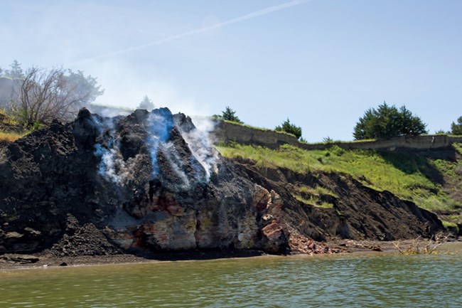
After traveling upstream about four-and-a-half months from St. Louis, the Corps found a natural phenomenon they surely found intriguing – a smoldering bluff along the Missouri River, about eight miles below the mouth of the Vermillion River in today’s Nebraska.
In August 1805, William Clark described the bluff as 180 to 190 feet high noting that “it appeared to have been recently on fire.” He said the crevice was too hot to keep their hands in it. But there were no flames, and Clark reported just witnessing searing heat and acrid fumes. Lewis stuck around the area to make additional observations and soon after became ill – it’s believed he likely inhaled some of the fumes, most likely sulfuric acid.
Known by the French trappers and traders as “Les Cotes Brulees,” the Burnt Hills bordered the west side of the Missouri River in today’s Lyman and Gregory counties of South Dakota, covering an area some 75 miles long from Scalp Creek (near Fort Randall Dam) to the mouth of the American Crow Creek (south of Oacoma, South Dakota).
The cause? Geologists of today explain that the phenomena of smoldering pits is centered on the fact that some of the shale deposits in this area contain oil, therefore making the rocks flammable. Some of the rocks also contain sulfide minerals which are known for their spontaneous oxidation and combustion.
Based on journal entries, this was the only location where smoldering outcrops were observed by the Corps. It’s likely the “fires” in other sections of the Burnt Hills were dormant at that time. Due to periodic river flooding, the creation of Lake Francis Case, and on-going erosion, the burn areas are today either extinct or have been covered. Those that remain are often dormant. However, occasionally a small section will smolder – which can be dangerously unstable, so it’s best viewed from a safe distance.
For more information on the Burnt Hills area, visit Snake Creek State Recreation Area, west of Platte, South Dakota. Or go to: https://gfp.sd.gov/parks/detail/snake-creek-recreation-area/
Image: South Dakota Magazine
Image Description: A photograph shows a small, dark rock face along the Missouri River which has smoke rising from it. Around the rock are green grass embankments with a few scattered trees. The river is in the immediate foreground.
