Last updated: June 3, 2021
Contact Us
Article
Black Jack Ruts Exhibits and Audio Description
NPS Exhibit
Photo/Roger Boyd
Orientation Exhibit Audio Description
-
Black Jack Ruts Orientation Exhibit Audio Description
Listen to the audio description of the Black Jack Ruts' orientation exhibit.
TrailheadWelcome to Black Jack Ruts and the Ivan Boyd Prairie Preserve. 783 words.
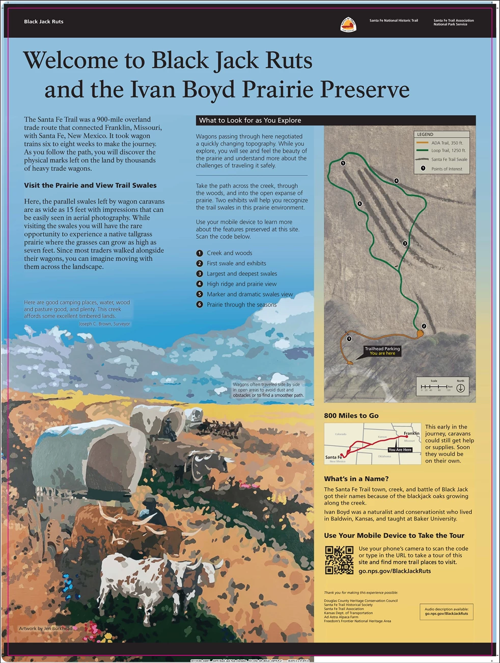
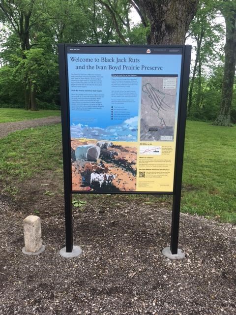
From the parking area, a wide gravel path leads to the wagon ruts. It curves to the right where it crosses a tree-lined creek with glimpses of the prairie beyond. Next to the path is this 3-foot-by-4-foot graphic panel.
In the upper right of the panel is a map of the area. In the lower left is a color illustration by Jen Burkhead showing three covered wagons moving across a yellow- and tan-colored prairie. One is in the lower left, facing diagonally toward the lower right. It is pulled by four oxen. The other two wagons are slightly behind and spaced to the right, moving in the same general direction. The middle one is pulled by oxen. The far wagon is pulled by mules. The caption reads, “Wagons often traveled side by side in open areas to avoid dust and obstacles or to find a smoother path.”
Above the illustration is a quote from Joseph C. Brown, Surveyor which reads, “Here are good camping places, water, wood and pasture good, and plenty. This creek affords some excellent timbered lands.”
Text at the upper left of the panel reads, “The Santa Fe Trail was a 900-mile overland trade route that connected Franklin, Missouri, with Santa Fe, New Mexico. It took wagon trains six to eight weeks to make the journey. As you follow the path, you will discover the physical marks left on the land by thousands of heavy trade wagons.”
“Visit the Prairie and View Trail Swales. Here, the parallel swales left by wagon caravans are as wide as 15 feet with impressions that can be easily seen in aerial photography. While visiting the swales you will have the rare opportunity to experience a native tallgrass prairie where the grasses can grow as high as seven feet. Since most traders walked alongside their wagons, you can imagine moving with them across the landscape.”
“What to look for as you explore. Wagons passing through here negotiated a quickly changing topography. While you explore, you will see and feel the beauty of the prairie and understand more about the challenges of traveling it safely. Take the path across the creek, through the woods, and into the open expanse of prairie. Two exhibits will help you recognize the trail swales in this prairie environment. Use your mobile device to learn more about the features preserved at this site. Scan the code below.”
The map at upper right shows the location of the wagon ruts and a loop trail around them. Numbered points of interest along the trail are identified by a list to the left of the map. The path at your current location begins near the lower left of the map, moves up, curves to the right where it crosses the creek in the woods (point 1), and ends at point number 2 near the lower center of the map. That section of the trail is colored amber and marks the ADA accessible portion of the trail. Point 2 marks the location of the first swale and exhibits. From that point the trail is green and continues up for about a quarter of the way. There it divides into a loop that crosses several Thick lines in dark gray which mark the location of the ruts or swales themselves. Moving counterclockwise, point 3 marks the place the trail crosses the largest and deepest swales. Farther along, point 4 marks a location on a high ridge with a prairie view. Point 5 is at the farthest point on the loop where there is a marker and dramatics swales view. Point 6 along the return path takes you through the prairie through the seasons.
At bottom right a small map shows the Santa Fe Trail from Franklin, Missouri to Santa Fe. Your current location in eastern Kansas is indicated. Text reads, “This early in the journey, caravans could still get help or supplies. Soon they would be on their own.”
“What’s in a Name? The Santa Fe Trail town, creek, and battle of Black Jack got their names because of the blackjack oaks growing along the creek. Ivan Boyd was a naturalist and conservationist who lived in Baldwin, Kansas, and taught at Baker University.”
“Use Your Mobile Device to Take the Tour. Use your phone’s camera to scan the code or type in the URL to take a tour of this site and find more trail places to visit. go.nps.gov/BlackJackRuts”
“Thank you for making this experience possible: Douglas County Heritage Conservation Council; Santa Fe Trail Historical Society; Santa Fe Trail Association; Kansas Dept. of Transportation; Ad Astra Alpaca Farm; Freedom’s Frontier National Heritage Area.”
End of Description.
NPS Exhibit
Photo/Roger Boyd
Swales on the Prairie Exhibit Audio Description
-
Black Jack Ruts Swales on the Prairie Exhibit Audio Description
Listen to audio description of the Black Jack Ruts' exhibit, Swales on the Prairie.
Swales on the PrairieSwales on the Prairie. 446 words.
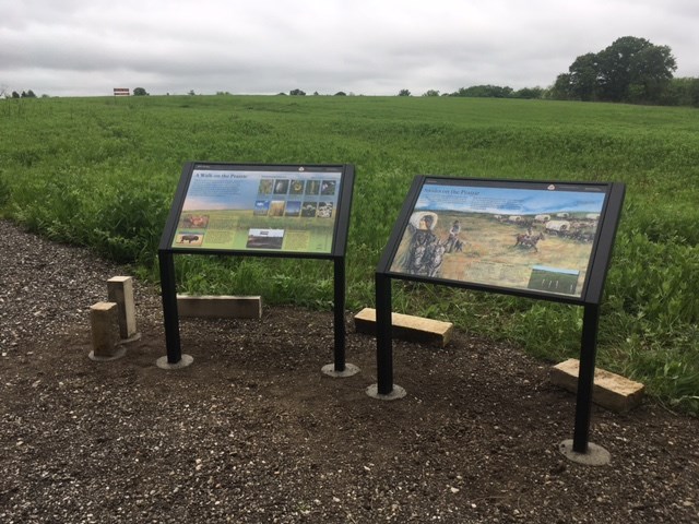
As you face this graphic panel at the side of the gravel path, you are looking out over a series of long swales running diagonally from your upper left to your lower right. They look like wide ditches covered with various grasses. The path continues to the left then curves towards the right to cross the swales. A small woody thicket lies on the far side of the swales.
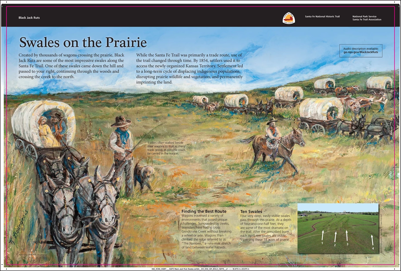
The graphic is three feet wide and two feet deep. The background shows a color illustration by Kathy Bourgeois of. A wagon train moving across a wide prairie. One covered wagon pulled by four mules is coming towards us at the lower left corner. A woman and a man sit in the wagon and another man walks alongside with a dog. A caption reads, “Traders often walked beside their wagons so that as many trade goods as possible could be carried in the wagon.”
Three more wagons form a line moving from upper center toward lower right and three more wagons move in the same direction farther to the right. Some are pulled by mules and others by oxen. One man rides a horse alongside the group. Text across the top of the panel reads, “Created by thousands of wagons crossing the prairie, Black Jack Ruts are some of the most impressive swales along the Santa Fe Trail. One of these swales came down the hill and passed to your right, continuing through the woods and crossing the creek to the north. While the Santa Fe Trail was primarily a trade route, use of the trail changed through time. By 1854, settlers used it to access the newly organized Kansas Territory. Settlement led to a long-term cycle of displacing indigenous populations, disrupting prairie wildlife and vegetation, and permanently imprinting the land.”
In the lower right corner of the panel is a small aerial photograph showing the four deepest and most visible swales, a whit arrow marking each. The trail crosses the swales in the foreground and then curves towards the distance. Text to the left of the photograph reads, “Finding the Best Route. Wagons traversed a variety of environments that posed unique challenges. Surrounded by creeks, teamsters here had to cross Grindstone Creek without breaking a wheel or axle. Wagons then climbed the ridge referred to as “The Narrows,” a nine-mile stretch of land between water hazards.”
“Ten Swales. Four very deep, easily visible swales pass through this prairie. At a depth of four-and-one-half feet, they are some of the most dramatic on the trail. After the prescribed burn each April, ten swales are visible, traversing these 18 acres of prairie.”
End of Description.
NPS Exhibit
A Walk on the Prairie Exhibit Audio Description
-
Black Jack Ruts Prairie Exhibit Audio Description
Listen to the Black Jack Ruts' Prairie Exhibit audio description.
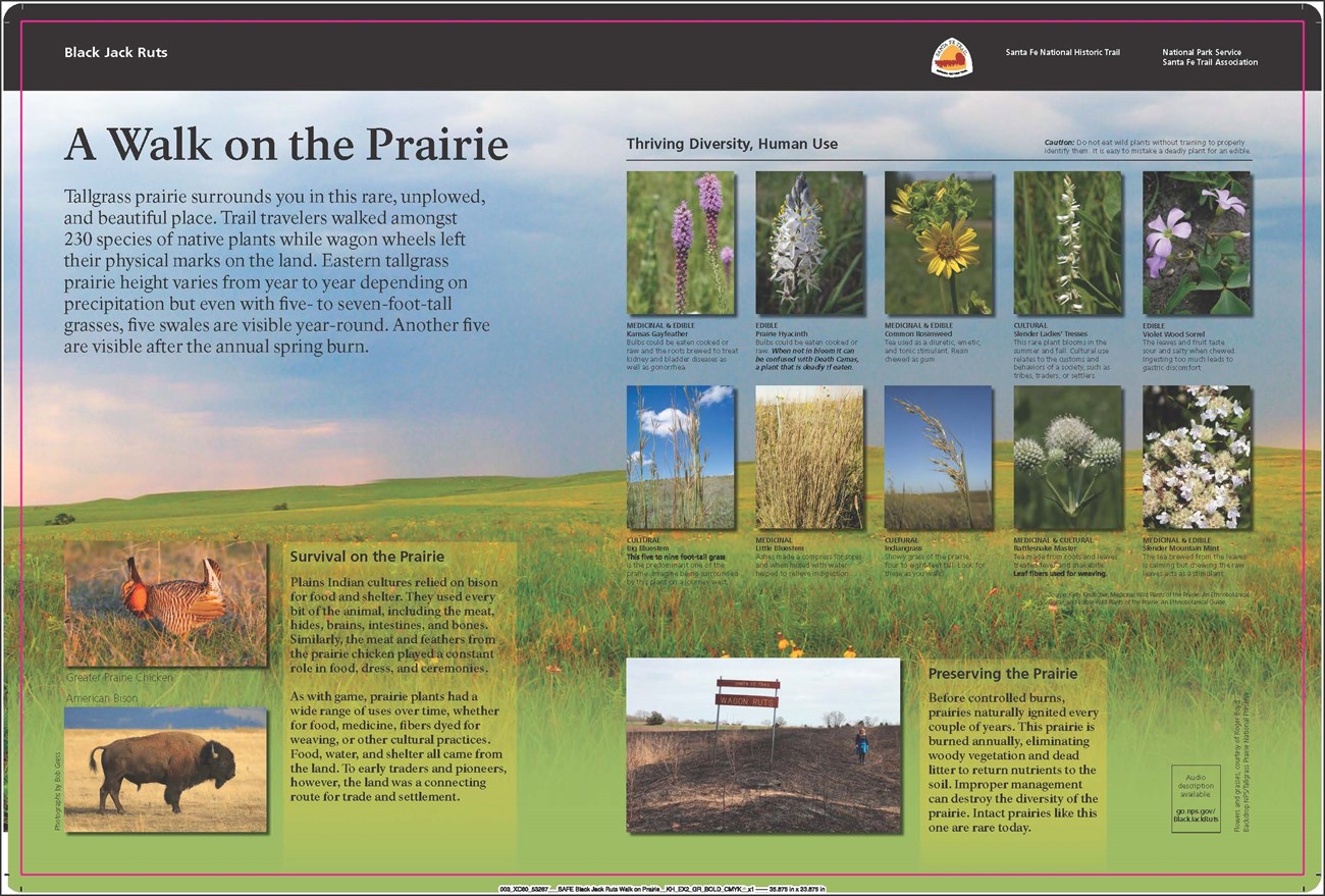
A Walk on the Prairie. 972 words.As you face this graphic panel at the side of the gravel path, you are looking out over a series of long swales running diagonally from your upper left to your lower right. They look like wide ditches covered with various grasses. The path continues to the left then curves towards the right to cross the swales. A small woody thicket lies on the far side of the swales.
The graphic is three feet wide and two feet deep. The background shows a photograph of a view across a gently rolling prairie. The grasses are green with yellow and red wildflowers dotted in the foreground. Tops of a couple of trees peek up past a small rise. Text at upper left reads, “Tallgrass prairie surrounds you in this rare, unplowed, and beautiful place. Trail travelers walked amongst 230 species of native plants while wagon wheels left their physical marks on the land. Eastern tallgrass prairie height varies from year to year depending on precipitation but even with five- to seven-foot-tall grasses, five swales are visible year-round. Another five are visible after the annual spring burn.”
In the upper right are ten photographs of flowers and grasses arranged in two rows. Text above the pictures reads, “Thriving Diversity, Human Use. Caution: Do not eat wild plants without training to properly identify them. It is easy to mistake a deadly plant for an edible”.
Beginning at the left end of the top row there is a picture of two long flower stalks with feathery purple blossoms open at the tops. The caption reads, “MEDICINAL & EDIBLE. Kansas Gayfeather. Bulbs could be eaten cooked or raw and the roots brewed to treat kidney and bladder diseases as well as gonorrhea.”
Next to the right is a photo of a cylindrical flower cluster with five-petaled white flowers. The caption reads, “EDIBLE. Prairie Hyacinth. Bulbs could be eaten cooked or raw. When not in bloom it can be confused with Death Camas, a plant that is deadly if eaten.”
Next is a picture of a green cluster with yellow, daisy-like flowers. The caption reads, “MEDICINAL & EDIBLE. Common Rosinweed. Tea used as a diuretic, emetic, and tonic stimulant. Resin chewed as gum.”
The next picture shows a slender flower stalk with white tubular flowers alternating on either side. The caption reads, “CULTURAL. Slender Ladies’ Tresses. This rare plant blooms in the summer and fall. Cultural use relates to the customs and behaviors of a society, such as tribes, traders, or settlers.”
The final photo in the top row shows several five-petaled pale violet flowers rising from low foliage with groups of three leaves. The caption reads, “EDIBLE. Violet Wood Sorrel. The leaves and fruit taste sour and salty when chewed. Ingesting too much leads to gastric discomfort.”
The leftmost photo on the second row shows the tops of several tall stalks of grass with groups of cylindrical seed clusters near the top. The caption reads, “CULTURAL. Big Bluestem. This five to nine foot tall grass is the predominant one of the prairie. Imagine being surrounded by this plant on a journey west.”
The next photo to the right shows a thick clump of medium-height grass stalks. The caption reads, “MEDICINAL. Little Bluestem. Ashes made a compress for sores and when mixed with water helped to relieve indigestion.”
Next is a picture of a grass stalk with a feather-shaped cluster of seeds at top. The caption reads, “CULTURAL. Indiangrass. Showy grass of the prairie, four to eight feet tall. Look for these as you walk.”
The next photo shows a stalk with several flower cluster at top, looking like prickly golf balls. The caption reads, “MEDICINAL & CULTURAL. Rattlesnake Master. Tea made from roots and leaves treated fever and snakebite. Leaf fibers used for weaving.”
The last photo in the row shows flat clusters of white flowers, some fully opened, others still in bid. The caption reads, “MEDICINAL & EDIBLE. Slender Mountain Mint. The tea brewed from the leaves is calming but chewing the raw leaves acts as a stimulant.”
Below the photos text reads, “Source: Kelly Kindscher, Medicinal Wild Plants of the Prairie: An Ethnobotanical Guide, and Edible Wild Plants of the Prairie: An Ethnobotanical Guide.”
At the bottom left corner of the panel are two photos of animals. The top one shows a Greater Prairie Chicken, a plump bird with brown and tan stripes on its body a tall ruff behind its head and large orange spots on the sides of its neck. Below that is a picture of an American Bison with its large shaggy head and short horns. Text to the right of the pictures reads, “Survival on the Prairie. Plains Indian cultures relied on bison for food and shelter. They used every bit of the animal, including the meat, hides, brains, intestines, and bones. Similarly, the meat and feathers from the prairie chicken played a constant role in food, dress, and ceremonies. As with game, prairie plants had a wide range of uses over time, whether for food, medicine, fibers dyed for weaving, or other cultural practices. Food, water, and shelter all came from the land. To early traders and pioneers, however, the land was a connecting route for trade and settlement.”
At lower right is a photograph looking down one of the swales. A woman stands at the bottom, showing that it is deeper than her waist. The ground is bare and blackened and a small sign reads, “Santa Fe Trail, Wagon Ruts.” To the right text reads, “Preserving the Prairie. Before controlled burns, prairies naturally ignited every couple of years. This prairie is burned annually, eliminating woody vegetation and dead litter to return nutrients to the soil. Improper management can destroy the diversity of the prairie. Intact prairies like this one are rare today.”
End of Description.
