Last updated: June 6, 2025
Article
Glacier Changes Drive New Challenges for Balancing Visitor Access and Natural Resource Protection
- Scott Gende, Natural Resources Team Lead, Alaska Region
- Jamie Womble, Program Manager, Southeast Alaska Network
- Andy Bliss, Physical Scientist, Southeast Alaska Network
When faced with these decisions, a prudent starting point for park managers is to ask whether limiting access or managing natural resources in a certain manner runs counter to the park’s founding purpose. Park purposes are derived from the act of Congress that set aside the unit for protection and provides the appropriate context for these decisions. For example, the founding mandate of some historical parks is to preserve landscapes for “authentic interpretation” of significant historical events, such as an important battle. Doing so allows visitors to experience the area as it was at the time of the historical event, thereby helping the park to meet its fundamental purpose. However, this may result in active manipulation of the park’s natural resources, such as maintaining a grassland that would normally be transforming into a forest due to successional dynamics (e.g., Young and Mahan 2023). In such a scenario, the impacts to the natural resources that result from intensive vegetation management is deemed acceptable in order to meet the site’s founding mandate.
While the tension between visitor use/access and natural resource protection has long been at the forefront of park decision making, rapid, landscape-scale changes are now forcing many park managers to reconsider what were historically deemed acceptable tradeoffs. These decisions are becoming more pressing owing to altered trajectories of plant and animal populations and fundamental shifts in ecosystem processes.
Here we describe an emerging issue in Glacier Bay National Park and Preserve that exemplifies the inherent difficulty when balancing resource protection with visitor access. Initially protected, in part, to provide access to tidewater glaciers, Glacier Bay will soon only have one accessible tidewater glacier. This glacier provides habitat for a large aggregation of harbor seals and is protected by limiting access. Thus, some difficult questions arise: Can the park still meet its founding mandate if existing tidewater glacier access restrictions persist? If not, are there access alternatives that produce acceptable levels of disturbance risk to seals? Our goal is to contextualize these questions by summarizing (1) the park’s founding purposes, (2) contemporary visitor access, (3) the dynamics of the tidewater glaciers and harbor seals in the park, and (4) the attributes of existing access regulations to help understand what’s currently deemed acceptable.
NPS
Founding Mandates and Visitor Access at Glacier Bay
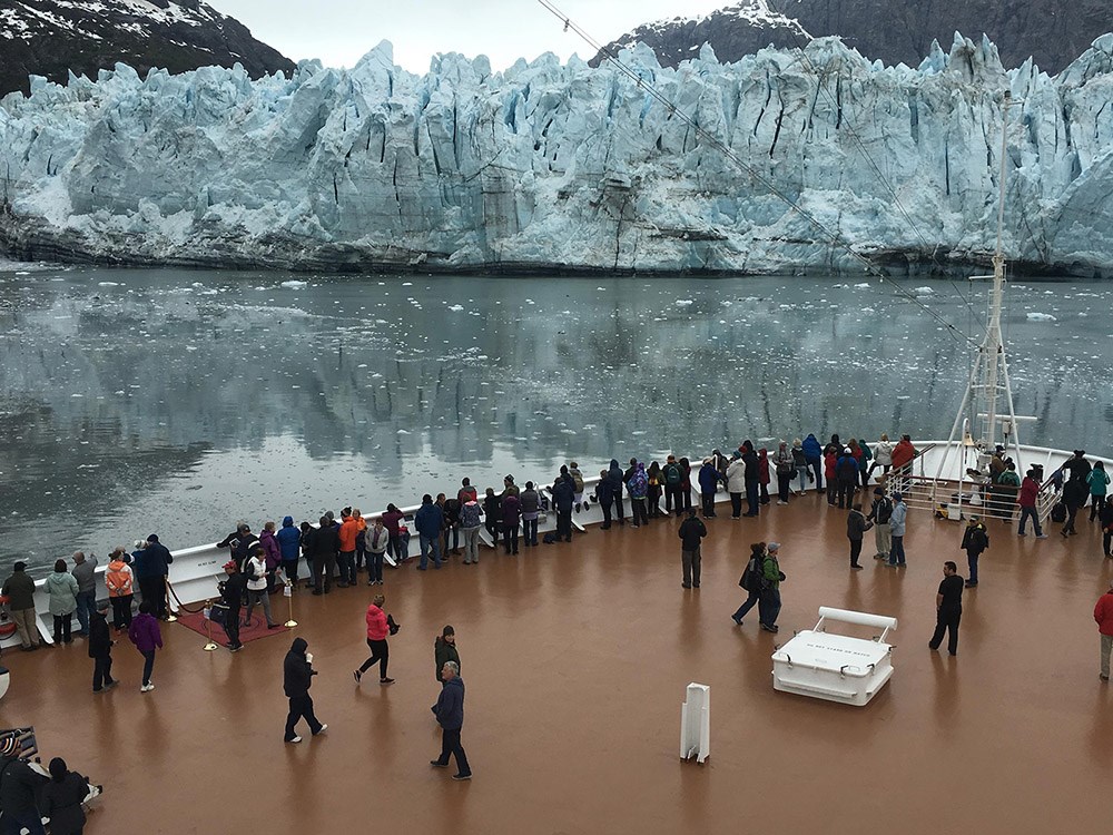
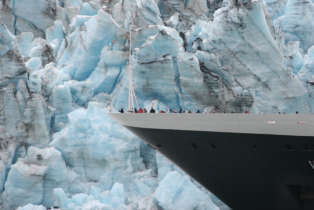
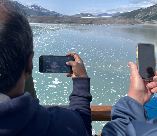
Glacier Bay was set aside for protection to achieve two fundamental purposes: to preserve an area that provides scientific opportunities to study landscape evolution in a dynamic glacial environment, and to protect an area where visitors can access and enjoy tidewater glaciers “of the first rank” by “ordinary travel.” In 1925, when Calvin Coolidge signed Presidential Proclamation #1733 that first protected Glacier Bay as a national monument, “ordinary travel” was by large steamship. Steamships started making transits into Glacier Bay as early as the late 1880s with the specific purpose of providing passengers access to the tidewater glaciers. Over time, steamships gave way to ocean liners and ocean liners evolved into large cruise ships. Today’s cruise ships, the largest of which (of those that currently visit Alaska) can carry nearly 5,000 passengers, bring more than 95% of the more than 700,000 visitors that annually visit the park. In addition to bringing a large volume of visitors, cruise ships also provide access to the tidewater glaciers to a wide diversity of visitors spanning socioeconomic backgrounds and physical capabilities, thereby making the park more “…accessible to every segment of American society” (NPS 2006). Given that there are no roads and few trails in the backcountry of the park, and owing to their historical access and reference in the original proclamation, cruise ships represent an important means by which the park meets its founding mandate.How does this access and enjoyment occur? When cruise ships visit Glacier Bay, they do not tie up to a dock or drop anchor to deploy tenders; all passengers remain onboard during the 8-12 hours the ship transits the fjord. Upon entry into the park, all cruise ships follow a similar course from the park’s entrance in Icy Strait up the western arm of Glacier Bay’s Y-shaped fjord and into Tarr Inlet to access and enjoy the Margerie Glacier. Depending on the density of icebergs calved from the glacier, the ships can often safely approach the glacier’s terminus, providing an extraordinary experience for visitors. Ships typically spend one to several hours near the tidewater glacier, which also allows on-board interpretation to occur.
NPS/Jamie Womble
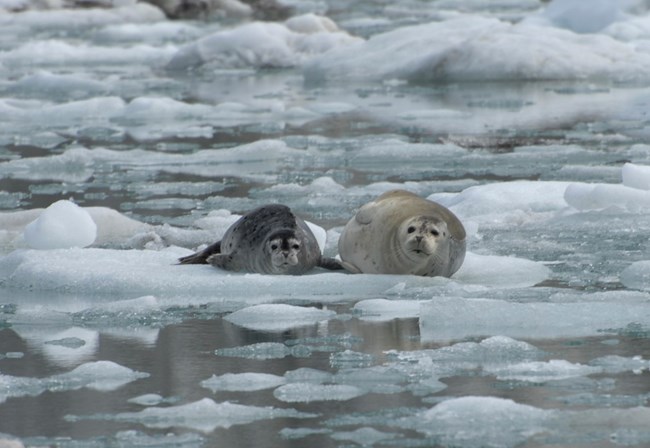
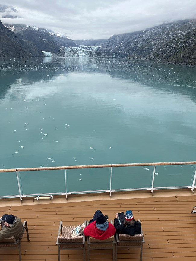
The unrestricted access to Margerie Glacier, and the extraordinary experience it provides, helps the park meet the mandate for access and enjoyment of a tidewater glacier “of first rank.” With this mandate met, the access restrictions for cruise ships to the Johns Hopkins Glacier are deemed acceptable, which allows the park to maximize protections from disturbance for the aggregation of seals in Johns Hopkins Inlet.
The Last Accessible Tidewater Glacier?
When Glacier Bay was first set aside for protection in 1925, a ship entering the fjord would be able to access a number of tidewater glaciers including but not limited to the Muir, Grand Pacific, Margerie, Lamplugh, McBride, and Johns Hopkins/Gilman (Figure 1; McNabb and Hock 2014). Today only Margerie and Johns Hopkins/Gilman glaciers are both tidewater and accessible, although their dynamics differ markedly.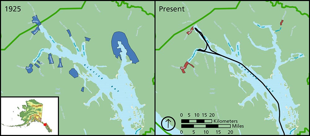
The right panel includes the route typically taken by cruise ships for most of the summer. Ships go to the face of Margerie Glacier in Tarr Inlet but turn around at Jaw Point at the mouth of Johns Hopkins Inlet so passengers see the glacier 7 miles away.
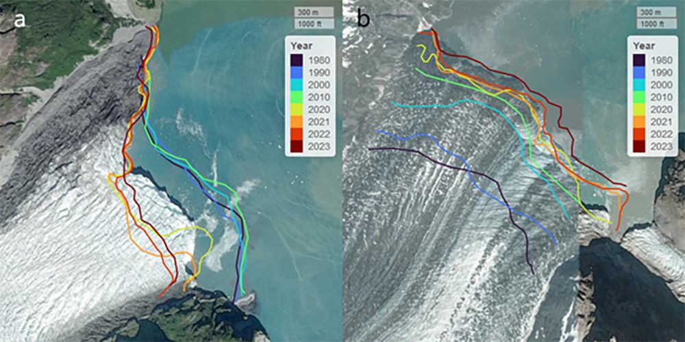
Outlines shown here were traced from Landsat and Sentinel satellite images (McNabb and Hock 2014, with updates by Bliss). Note: the color scale is decadal from 1980-2020, and then annual 2020-2023. Background images © ESRI.
Seasonal Dynamics of Seals and Ice
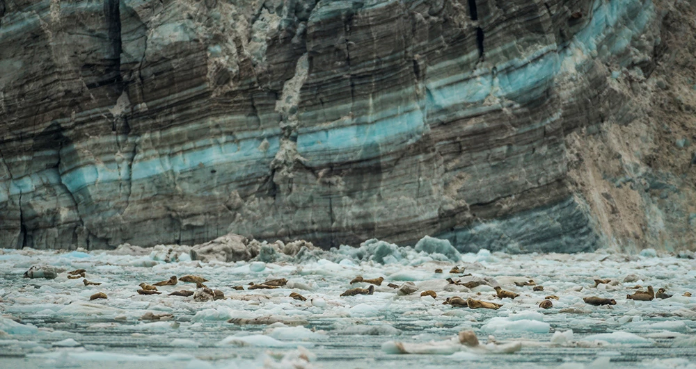
Managers at Glacier Bay National Park and Preserve have a long history of supporting research and monitoring efforts to help inform decisions when resources and values may be impacted by vessel operations and visitor activities (e.g., Gende et al. 2005, Piatt and Gende 2007). Given more than 30 years of managing visitor access in areas used by harbor seals, it’s not surprising that the park has supported long-term monitoring of the harbor seal aggregations in Glacier Bay since the 1990s (Mathews and Pendleton 2006, Womble et al. 2010, Womble et al. 2020). In sum, up to 4 replicate aerial photographic surveys are flown each year in mid-June, coinciding with the peak in pupping, and in mid-August to coincide with the peak in molting. In Johns Hopkins Inlet, the surveys follow a systematic route, whereas a more opportunistic route is flown to cover the myriad beaches, reefs, islands, and islets (collectively, “terrestrial sites”) that are also used by seals throughout the summer. All photos are analyzed to estimate the total number of seals present. These data have generated important insights into the dynamics of seals and ice, with possible implications regarding access restrictions in Johns Hopkins Inlet.
Foremost, analysis of the data during the first several decades of monitoring revealed that, in June, icebergs and harbor seals were typically spread throughout the inlet including areas just up to, and at times beyond, Jaw Point. By August, the density and distribution of ice had diminished significantly (up to 7 times reduction) resulting in seals and ice becoming highly clustered near the terminus of the glacier (Womble et al. 2020, Womble et al. 2021). More recently, however, the phenomena of largely clustered ice and seals near the glacier’s terminus has been documented during the June surveys as well (Figure 3), possibly due to the growth of the glacier’s end moraine (Kaluzienski et al. 2023).
UNESCO/Mark Kelly
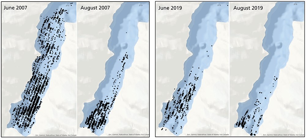
Together, the research and monitoring results demonstrate that the risk of seal disturbance, particularly near the mouth of Johns Hopkins Inlet, is comparatively much lower in recent years compared to several decades ago owing to larger expanses of open water free of both ice and seals. While these results are timely and scientifically derived, they do not resolve whether the lower level of risk represents an acceptable level of risk. We thus review the attributes and implications of the existing access restrictions to help contextualize what’s currently acceptable.
Acceptability in Disturbance Risk
Access restrictions to Johns Hopkins Inlet for cruise ships (and other vessels) have been in place since the 1990s by designating a line that demarcates when and where cruise ships can go. Prior to the tourism season, park staff communicate to the cruise ship companies the suite of restrictions and operating requirements for the upcoming summer, including a reminder of the “line” in place from 1 May through 31 August, that extends due west from Jaw Point separating the go/no-go area. This access regulation is easily understood, can be designated on an electronic chart, and is communicated in sufficient time prior to the season to allow ships to integrate into navigational planning. As a result, violations of the regulation are exceedingly rare.However, the designation of a static line at Jaw Point, and the decision to allow access to Margerie Glacier throughout the summer, represents a management approach for reducing, rather than eliminating, the risk of disturbance to seals. For example, there are a number of days, particularly in the early part of the summer, when large volumes of icebergs and, at times, many hauled-out seals, have drifted past Jaw Point and into the area where cruise ships are allowed. While ships are expected to maneuver to avoid disturbing seals (“except when safe navigation requires”), icebergs drifting into the cruise ship route constitutes an infrequent yet unavoidable scenario throughout the summer. What’s more, private, tour, and charter vessels are afforded access to Johns Hopkins Inlet beginning 1 July (CFR 36 13.1178 2025) and these vessels have also been documented disturbing seals, albeit at lower rates than cruise ships (Young et al. 2014). Finally, monitoring data have demonstrated that a small number of harbor seals still use icebergs in Tarr Inlet during the summer, occasionally including mothers with newborn pups. Indeed, NPS interpretative rangers traveling on the ships regularly point out seals on ice to passengers as part of the outreach efforts when ships are near the Margerie Glacier.
The current approach to managing acceptable levels of seal disturbance is based, in part, on static decisions: when and where vessels are allowed is designated independent of the actual conditions vessels would encounter in those areas during those periods. An alternative would be a more dynamic (adaptive) approach, although it is worth noting the hurdles that the park would face if it pivoted to a framework where access restrictions are based on ice and seal distributions encountered in real time. For example, recent studies have demonstrated that ice in the inlet can be highly variable depending on ice calving dynamics and local environmental variables including winds, currents, and tides (Kaluzienski et al. in press). Thus, it is unclear how long after a survey is conducted that the data would reflect the conditions in the inlet given that they can change daily or even hourly. Alternatively, the park could use satellite imagery to help inform the dynamic decision, although persistent cloud cover can preclude accurate information for weeks at a time. Finally, images from land-based cameras can be collected (and possibly transmitted) on an hourly basis (Keinholz et al. 2019, Kaluzienski et al. in press), but would need to be summarized and conveyed to ships in a useable format in near real-time—a labor-intensive and time-consuming process.
In 2023, a partnership was initiated between the NPS, the University of Texas, and Texas A&M University (with support from the National Science Foundation) with the goal of using existing data from research and long-term monitoring to better understand disturbance risk under possible alternatives to the existing access restrictions in Johns Hopkins Inlet. While the project will focus on developing state-of-the-art quantitative tools to explore different scenarios, ultimately it will be up to park managers to define acceptable risk levels relative to the benefits of enhanced visitor access. Through careful assessment of the science of seal behavior and a commitment to continued long-term monitoring of the seal population, the park is in excellent position to identify alternatives that fulfill the enabling legislation of the park and helping to resolve the inherent conflict of the dual mandate.
References
CFR 36 13.1178. 2025.Closed waters, islands and other areas. Available at: https://www.ecfr.gov/current/title-36/chapter-I/part-13/subpart-N/subject-group-ECFR519bb9a921283f6/section-13.1178 (accessed 30 April 2025)
Gende, S. M., A. N. Hendrix, and J. Schmidt. 2019.
Somewhere between acceptable and sustainable: When do impacts to resources become too large in protected areas? Biological Conservation 223: 138-146.
Gende, S. M., B. Kipple, C. Morehouse, G. C. Blundell, J. Bodkin, J. Jansen, L. Cerveny, and R. Schroeder. 2005.
Research and monitoring needs relevant to decisions regarding increasing seasonal use days for cruise ships in Glacier Bay. Glacier Bay National Park Science Advisory Board: Final Report. 112 pp.
Harding, K. C., M. Fujiwara, Y. Axberg, and T. Härkönen. 2005.
Mass-dependent energetics and survival in harbour seal pups. Functional Ecology 19(1): 129-135.
Jansen, J. K., P. L. Boveng, S. P. Dahle, and J. L. Bengston. 2010.
Reaction of harbor seas to cruise ships. Journal of Wildlife Management 74: 1186-1194.
Kaluzienski, L. M., J. M. Amundson, J. N. Womble, A. K. Bliss, and L. E. Pearson. In press.
Fine-scale variability in iceberg velocity fields and implications for an ice-associated pinniped. The Cryosphere.
Kaluzienski, L. M., J. M. Amundson, J. N. Womble, A. K. Bliss, and L. E. Pearson. 2023.
Impacts of tidewater glacier advance on iceberg habitat. Annals of Glaciology 64(90): 44-54.
Kienholz, C., J. M. Amundson, R. J. Motyka, R. H. Jackson, D. A. Sutherland, J. D. Nash, D. S. Winters, W. P. Dryer, and M. Truffer. 2019.
Tracking icebergs with time-lapse photography and sparse optical flow, LeConte Bay, Alaska, 2016-2017. Journal of Glaciology 65(250): 195-211.
Larsen, C. F., R. J. Motyka, A. A. Arendt, K. A. Echelmeyer, and P. E. Geissler. 2007.
Glacier changes in southeast Alaska and northwest British Columbia and contribution to sea level rise. Journal of Geophysical Research: Earth Surface 112(F1).
Mathews, E. A. and G. W. Pendleton. 2006.
Declines in harbor seal (Phoca vitulina) numbers in Glacier Bay National Park, Alaska, 1992-2002. Marine Mammal Science 22: 167-189.
McNabb, R. W. and R. Hock. 2014.
Alaska tidewater glacier terminus positions, 1946-2012. Journal of Geophysical Research, Earth Surface 119: 153-167.
National Park Service (NPS). 2006.
Management Policies. U.S. Government Printing Office, Washington, DC.
Piatt, J. and S. M. Gende. 2007.
Proceedings of the Fourth Glacier Bay Science Symposium. USGS Alaska Science Center. Scientific Investigations Report 2007-5047.
Womble, J. N., P. J. Williams, R. W. McNabb, A. Prakash, R. Gens, B. S. Sedinger, and C. R. Acevedo. 2021.
Harbor seals as sentinels of ice dynamics in tidewater glacier fjords. Frontiers in Marine Science 8: e634541.
Womble, J. N., J. M. Ver Hoef, S. M. Gende, and E. A. Mathews. 2020.
Calibrating and adjusting counts of harbor seals in a tidewater glacier fjord to estimate abundance and trends 1992 to 2017. Ecosphere 11(4): e03111.
Womble, J. N., G. W. Pendleton, E. A. Mathews, G. M. Blundell, N. M. Bool, and S. M. Gende. 2010.
Harbor seal (Phoca vitulina richardii) decline continues in the rapidly changing landscape of Glacier Bay National Park, Alaska 1992-2008. Marine Mammal Science 26(3): 686-697.
Young, J. A. and C. G. Mahan. 2023.
Assessing tradeoffs between current and desired vegetation condition in a National Park using historical maps and high-resolution lidar data. Restoration Ecology 31(5): e13911.
Young, C., S. M. Gende, and J. T. Harvey. 2014.
Effects of vessels on harbor seals in Glacier Bay National Park. Tourism in Marine Environments 10(1-2): 5-20.
