Part of a series of articles titled The Treaties of Fort Stanwix.
Previous: Treaties of the Fort
Article

The National Archives
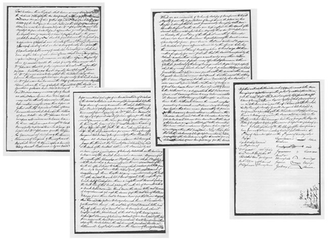
Nicknamed "the Fort Stanwix Land Lottery and Sweepstakes Treaty" by James H. Merrill in his book Into the American Woods: Negotiations on the Pennsylvania Frontier (2000, ISBN-13: 978-0393319767), the 1768 Boundary Line Treaty of Fort Stanwix was controversial before the ink dried on the parchment on November 2. The goal of the treaty was to resolve issues between American Indians west of the colonies, however the treaty would have profound impacts on the British American colonies, and later the young United States of America.
As a result of the 1763 Treaty of Paris which brought to an end the French and Indian War, also known as the Seven Years War (1756-1763), France ceded her North American colony to Great Britain. American Indians became dissatisfied with British policies towards them. As a result, an American Indian War for Independence started with the siege of Fort Detroit in April 1763. This war spread to the east and south. Known in the United States as Pontiac's Rebellion, named after the Ottawa leader, the conflict lasted from 1763 to 1764, with skirmishes continuing until 1765.
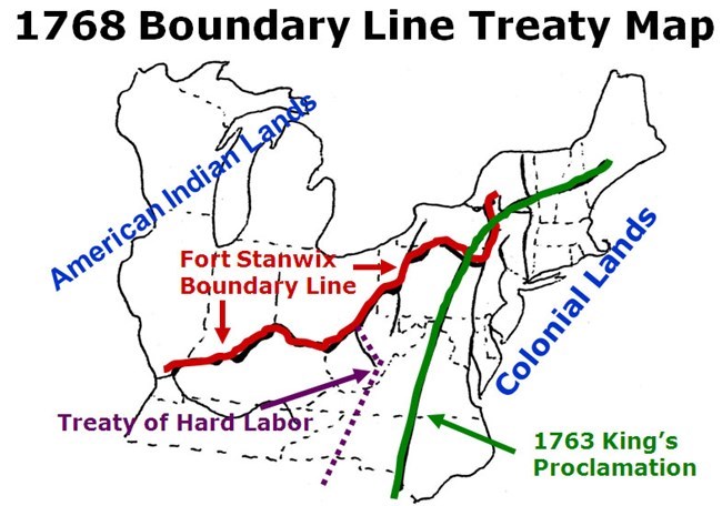
Of great concern to the colonists and British authorities was that a pan-Indian union was forming to the west of colonial lands. In October 1763, King George III unilaterally issued a royal proclamation establishing a boundary between American Indian to the west and British colonial lands in the east. The goal was to calm the American Indian unrest. This boundary was problematic from the outset. Land speculators had claims to lands on the Indian side of the line and similarly colonists had settled west of the boundary. There was also the problem that American Indians were living east of the boundary.
In July 1766, Pontiac and Sir William Johnson (British Superintendent of Indian Affairs, Northern Department) signed a treaty at Fort Ontario, in present day Oswego, New York which effectively ended the conflict, but did not resolve all of the concerns that started the war.
For the next two years Johnson and John Stuart (Superintendent of Indian Affairs, Southern Department) petitioned the British Board of Trade for treaties to be negotiated to formalize the boundary line established by the 1763 Royal Proclamation and resolve concerns of colonial settlers and officials and land speculators. The Board of Trade approved this request in 1768 and stipulated where the boundary line was to be drawn. The boundary line would start at Fort Stanwix, proceed south and west to the confluence of the Ohio and Kanawha Rivers, up the Kanawha River to its headwaters (located in present-day West Virginia), then south to Spanish East Florida.
Prior to receiving this approval, the Six Nations (Iroquois) negotiated a peace treaty with the Cherokee Nation. The Six Nations were better supplied than the Cherokee with access to British military arms and were perceived as winning the war. This treaty, negotiated at Johnson's home Johnson Hall, was signed in February 1768 and ended a war that was fought between the nations. This treaty was negotiated after repeated petitions from Virginia and North Carolina officials in response to Cherokee requests which Johnson resisted for months. Johnson had preferred for the nations to continue fighting. After the treaty was concluded, John Stuart reported to Johnson that when the Cherokee representatives returned home stated they were satisfied with the treaty results.
Once the Board of Trade's instructions were received by Johnson and Stuart they requested the Indian nations to attend councils in order to negotiate the boundary. The first council was held by Stuart where he negotiated the Treaty of Hard Labour with the Cherokee. This treaty was concluded on October 17, 1768, and drew a boundary line from the confluence of the Ohio and Kanawha Rivers, to the headwaters of the Kanawha River, then south to Spanish East Florida.
Johnson called the council in the north to be held at Fort Stanwix. The treaty grounds surrounded the dilapidated fort which had been abandoned by the British Army in 1765. A council house, living quarters for colonial officials, a storage building, and structures for craftsmen such as blacksmiths were constructed in advance of the negotiations. Colonial officials attending the council at Fort Stanwix included Johnson of New York, Sir William Franklin the Royal Governor of New Jersey, Frederick Smyth the Chief Justice of New Jersey, Dr. Thomas Walker of Virginia, and Richard Peters and Joseph Tilghman of Pennsylvania. Johnson recorded over 3,000 American Indians attending the council.
The American Indians began arriving at Fort Stanwix in August, with the negotiations lasting through September and October. On November 5, 1768, representatives for the Mohawk, Oneida, Tuscarora, Onondaga, Cayuga and Seneca signed the Boundary Line Treaty on behalf of the Six Nations, Shawnee, Delaware, Mingo and other dependent tribes, and ceded interests in land east and south of the boundary to Great Britain. The boundary line drawn starts at Fort Stanwix and proceeds south and west to the confluence of the Ohio and Kanawha Rivers as outlined in the Board of Trade's instructions. But, then continues down the Ohio River to its confluence of the Tennessee River (then known as the Cherokee or Hogohege River), further west than the Board of Trade's instructions.
Why the boundary line was extended west beyond the Board of Trade's instructions is subject to interpretation. For the Six Nations they were protecting their homelands from encroaching colonial settlement. But why did they negotiate a line as far west as they did? A clue may be found in the statement made by the Six Nations during the 1784 Treaty of Fort Stanwix.
"We are the only persons adequate to treat of, and conclude a peace, not only on the part of the Six Nations, but also on that of the Ottawas, Chippiwas, Hurons, Potowatamas, Messasagas, Miamis, Delawares, Cherokees, Chicasas, Coctas, and Creeks, and establish peace in the name of them all. Whatever Conclusion is made at this treaty will be strong, and whatever passes will be communicated throughout the various tribes."
Over a long period of time the Six Nations had extended their influence over other Indian nations including their successful war against the Cherokee which requested a peace treaty be negotiated earlier that year. Because of this the Six Nations were in a position to negotiate a treaty favorable to their interests by negotiating a boundary line that veered sharply to the west once it reached the Six Nations' southern border. Johnson was reacting to his own personal interests and the interests of land speculators and colonial settlers. He was also concerned about the French intrigue from the Spanish forts and communities along the Mississippi River and wanted to check this French threat to British and colonial interests. Johnson also inserted a wide wedge between American Indian nations to the west attempting to stop a pan-Indian union from forming again. Plus, the nations would be at odds with one another which would also aid in keeping the union from forming as well.

National Park Service
Without a doubt the treaty was controversial. Locally the Oneida and Sir William Johnson disagreed about whether the boundary line started on the east or west end of the Oneida Carrying Place that Fort Stanwix protected during the French and Indian War. If the line started on the east end, then the carry was controlled by the Oneida; if on the west end, the carry was controlled by the British and its New York colony. In the bigger picture, the Board of Trade was concerned about starting renewed conflict with and between the American Indian nations. Stuart also complained about the Fort Stanwix boundary line which negatively impacted his relationship with the Cherokee and called into question the line negotiated in the Treaty of Hard Labour. The Board of Trade and General Jeffery Amherst chided Johnson and ordered him to renegotiate the line to end at the confluence of the Ohio and Kanawha Rivers. Johnson refused. In future years the 1770 Treaty of Lochaber with the Cherokee was negotiated to adjust the line drawn by the Treaty of Hard Labour, and the Fort Stanwix line was adjusted in 1773 within Pennsylvania to finalize the Line of Property, also know as the Purchase Line.
Although the 1768 Boundary Line Treaty was controversial and an ominous sign for American Indian nations in respect to their future relations with the British and later the young United States, it is important to the westward expansion of the United States. The legacy of this treaty is that although relations between colonial settlers, land speculators and officials, and the American Indian nations remained strained, there was less conflict in the west permitting colonial settlers and land speculators to surge westward. This treaty opened lands that would eventually become parts of western Pennsylvania, Maryland, Virginia, and northeast Tennessee, and the future states of Kentucky (1792) and West Virginia (1863) which seceded from Virginia during the American Civil War.

Part of a series of articles titled The Treaties of Fort Stanwix.
Previous: Treaties of the Fort
Last updated: February 23, 2023