|
Wrangell-St. Elias is a wonderland of geology. Massive peaks, volcanoes, countless glaciers, and huge rivers set the stage for unsurpassed geologic exploration. This diverse landscape attracts researchers from all over the world to investigate volcanism, glaciation, plate tectonics, and quaternary geology. 
Diverse Origins Southern Alaska is a patchwork of geologically distinctive crustal fragments separated by major fault systems. These fragments exist in all shapes and sizes, but each has a history of its own. All are exotic—that is, they were formed elsewhere and transported to their present position by the motions of crustal plates. Some have been rotated relative to their neighbors, and some have been displaced vast distances compared to less traveled nearby fragments. Thus, adjacent fragments generally differ in the characteristics of the rocks which constitute them—their lithologies, and they differ in the structural modifications that those rocks have undergone—their tectonic histories. Thus, these fragments are called lithotectonic terranes—or, in shorthand, just terranes. In southern Alaska, juxtaposition of disparate terranes has created a collage on a grand scale. Collectively, the processes by which the collage was assembled (by which south-central Alaska has grown by the addition of exotic terranes over the past 200 million years or so) are termed accretionary tectonics. This process continues in Alaska today: the latest terrane to arrive—the Yakutat terrane—still is being displaced, jamming against and beneath terranes to the north and west. Fragmented Terranes The makeup of these terranes is diverse: some represent pieces of old continental crust, whereas parts of others consist of oceanic crust. Some fragments represent the remains of volcanic island chains formed in the open ocean (like the Aleutian islands). Others represent volcanic chains formed on the edge of a continent (like western South America). Some terranes consist almost totally of old eroded material from the edge of North America. Where these Alaskan terranes were formed originally and how they came to be fragmented and brought to Alaska is obscure. Most are presumed to have been derived from in and around the Pacific Ocean basin. Some may have been brought as “rafts” propelled on a conveyor belt of converging oceanic crust. Given sufficient time, oceanic crust created by seafloor spreading has the potential to convey exotic terranes great distances from their places of origin. Other terranes may have been brought northward along faults near the edge of the continent. The Yakutat terrane provides a prime example, having been transposed 375 miles along the Queen Charlotte–Fairweather transform fault system in the last 30 million years. In fact, it has been shown that so much of Alaska consists of displaced terranes that less than 1 percent of Alaska’s total area is an original part of the North American continent. It is against this ancient continental edge that all terranes to the south accreted, including all the rocks of Wrangell–Saint Elias National Park and Preserve. The park includes parts of seven terranes. From north to south, they are the Windy, Gravina Belt, Wrangellia, Alexander, Chugach, Prince William, and Yakutat terranes. 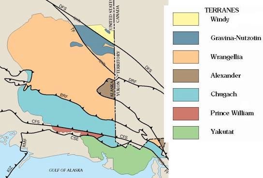

Forces of Change Wrangell-St. Elias National Park and Preserve is a fantastic laboratory and its extraordinary collection of mountains and geologic features was one of the primary reasons for the creation of the park. Four mountain ranges exist within the park - the Wrangell Mountains, St. Elias Mountains, Chugach Mountains, and the Alaska Range (Mentasta/Nutzotin Mountains) - and were created by the collisions of plates in the earth's crust. Many of the peaks within the Wrangell Mountains were once active volcanoes. Today, only Mount Wrangell (14,163') remains active. Geologist have concluded that the bedrock underlying these mountains formed much further south than its present position, perhaps off of California. The movement of this terrane northward and its collision with other crustal plates caused volcanic activity, subduction, and uplift resulting in massive mountain ranges in Alaska. These plate tectonics remain an active and powerful force of change today. On November 3, 2002 a massive 7.9 magnitude earthquake located in the central Alaska Range extended eastward along the Denali and Toshunda faults, rocking the northern district of the park. Displacement of the fault reached 5 meters in places. Damage to roads and personal property was extensive, but nobody was killed or seriously injured. This earthquake caused incredible changes to the topography of the region. Bedrock fractures were reactivated, cracks appeared in the surface and mountainsides, and huge mudslides came down many slopes. Scientists will be studying the impact of this earthquake for many years. As you travel throughout the park, imagine the forces and processes of change that created the beautiful scenery and then remember that those same forces continue their work today. This place looks different now than it did six months ago...what will it look like when you visit? Learn More!Geologic Guide to the Volcanoes of the Western Wrangell Mountains (pdf format, 8.8MB) USGS Geologic Map of Wrangell-St. Elias (USGS website, pdf format, 27 MB) Icy Bay Mega TsunamiDo you remember the giant tsunami in Icy Bay in 2015? 200 million metric tons of rock slid down the mountain in a crash that must have been deafening. It hit the ocean, sending up a wave that peaked at nearly 600 feet high. The wall of water stripped alder thickets from the hillside, tossed boulders up hills and carpeted the land in rubble from the bottom of the ocean. To learn more about this amazing event, check out the videos, https://youtu.be/QwjOP6FApsA (video 16:53 minutes) https://vimeo.com/186305663 (trailer 2:25 minutes)
Visit our keyboard shortcuts docs for details
Taan Fjord, Icy Bay, Alaska. The friction that held silt to silt and rock to rock began giving way. Those first rocks shoved more rocks, and then more still. Some 200 million metric tons of rock slid down the mountain in a crash that must have been deafening. It hit the ocean, sending up a wave that peaked at nearly 600 feet high. The wall of water stripped alder thickets from the hillside, tossed boulders up hills and carpeted the land in rubble from the bottom of the ocean. Video by Ground Truth Trekking. Earth Science Articles |
Last updated: February 17, 2023