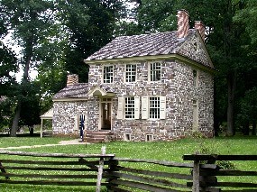
NPS Photo A Lesson in ContextJune 2 - 6, 2009The start of every archaeological excavation begins with laying in a grid. We are digging in 5ftx5ft excavation units, and we have oriented them parallel to the foundations of the Potts house. Our grid is 10 feet by 30 feet, giving us a two-by-six layout of squares aligned to the building, and they are marked with neon green mason’s line wrapped around galvanized spikes. We have assigned each unit a letter designation, starting with the northwest unit “A”. In addition to units being named by letters, we are designating each layer within the units by number. Therefore, the topsoil of every unit is “Level 1”, and subsequent layers are numbered as we come upon them. This is not to say that every “Level 2” will be the same soil, but every layer below topsoil in each unit will be called “Level 2” and so on. Once our grid is on the ground, we will establish a “datum”, a point from which we will record all elevations of the soil levels across the site. Having a datum is very important to a scientific archaeological excavation; it is the depth measurement, as well as the letter of the unit that are used to give artifacts and features “context”. Archaeologists can understand a lot about a site and a time period not only through the artifacts themselves, but from where those artifacts are found in the ground; the artifact itself, its historical function, and its location upon excavation all play a role in interpreting what it may have meant to someone, or to whom it may have belonged. Recording that something is found in unit A, level 3 is good, but recording exactly how many feet below our assigned datum “Level 3” occurs, is even better; the more accurate our measurements, the more accurate our interpretations. As you can see, it is more complicated than you might think to set up a proper archaeological investigation! The end of this week will include breaking ground, and the stripping of sod off of units C and D. The park archaeologists who observed and recorded the site in 1986 covered what they saw in plastic before they backfilled, so we know how deep to go to reach the bottom of our first layer. We expect to see many modern artifacts, but also some earlier objects, because the soil that was used to fill in the space was never sifted through screens to find artifacts. Already, the site is confirming our suspicions, but as we dive below the plastic, we hope to find some intact deposits from historical periods, particularly from the Continental Army’s 1777-1778 encampment. 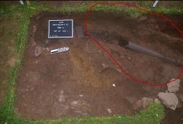
NPS Photo A Lesson in FeaturesJune 9 - 13, 2009This week, as we are pulling up the plastic from the 1986 excavation/observation, we are encountering soil which we expect is not from the encampment period. This soil is “fill” from an earlier landscaping episode. In fact, it may represent any or all of the following: the construction or the destruction of the 19th century Jones family addition, or the construction or the destruction of the 1887 interpretation of General Washington’s dining hut, all included with soil and artifacts churned up from the 18th century. Additionally, in our units that overlap previous excavations, it could represent the backfilling of the 1973 archaeological investigations. What this means is that we are still unable to recognize a layer of soil that is specifically a ground surface from the 18th century. We are, however, beginning to notice an interesting soil stain in unit E. It is not a uniform circle or square, but it has distinct edge; in other words, the dirt in the stain is very different from the rest of the soil on that level in unit E. In 1986, the archaeologists noted this feature and mapped it, calling it a trash pit labeled “Feature 1”. We have circled it in red. In order to dig a feature, several steps must be taken in preparation. First, technical drawings are made of the excavation unit(s) in which the feature sits. After the plan view (bird’s eye view) of the unit is drawn, elevations are often taken of the feature itself. Finally, a string line is established across the very middle of the feature, bisecting it at its longest points. It is often necessary to dig features in halves in order to understand the stratigraphy (layers) of soil within them, because it differs from that of the soil around it. Small tools like trowels and spoons are perfect for excavating small spaces. Since features are rarely uniform in shape as not only at their surfaces, but as they go down, archaeologists often need to improvise their tools. 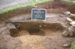
NPS/VAFO When most people think of archaeology, they think first of the artifacts, the small treasures we find in pieces in the soil, but features are just as important as artifacts, if not more so, because they alert us to undisturbed period deposits. On such a complex site as Washington’s Headquarters, we really look to the features to highlight each occupation period of the house, so that we can pinpoint the encampment period story on which we are focused. 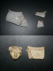
NPS/VAFO June 16-20, 2009 A Lesson in Artifacts
This week has been especially rainy! We’ve been in the lab a few days, processing artifacts, so this entry is a great opportunity to talk about the small objects we find in every bucket of dirt. Our particular favorites include some of the artifacts that came out of last week’s Feature 1.
On the right (top) are pieces of a porcelain teapot, hand-painted in red and black. It once also had gold leaf decorating it, but that is often lost in the archaeological record, especially on an object like this, which is painted over the glaze. On the right (bottom) are two piece of creamware. The one on the left is a cherub face that probably once decorated a fancy soup tureen or other serving piece, and the one on the right is a rim sherd from a highly decorated plate (you can see if you look closely a vine of laurel leaves, and some feathered moulding as well). All of these objects are things that would have belonged to the elite classes; no enlisted soldier in a hut would be using such beautiful pieces. These objects were almost certainly used by the General Washington and his officers.
Being in the lab gives each of the archaeologists (and our volunteers!) a chance to get up close and personal with all of the objects we’ve recovered so far. Everyone on the site doesn’t necessarily get to see every artifact coming out of the screens, so having a lab day is a good way to get up to speed on the kinds of things we’re finding. 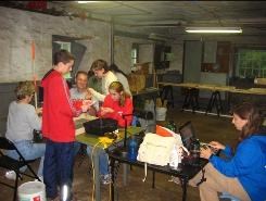
NPS/VAFO People don’t often get to see or experience what happens to the artifacts once they are out of the ground, but the rest of the process is very important! After artifacts are either gently washed with water and a toothbrush, or gently dry-brushed with a toothbrush, they are set out to dry. Later they are labeled and put into a catalog of artifacts for researchers and workers to reference later on. Eventually they are put into archival plastic bags for permanent storage with the collections held by the National Park Service. All of these artifacts belong to the American public, and are held in trust by the NPS, which cares for them in perpetuity.
Finding artifacts is probably one of the best parts of the job; it is literally our link to the past. This is the way in which we can reach out and touch the fingertips of the previous owners of each object. We treat the artifacts with care both in the field and in the lab, because their preservation is paramount to allowing not just ourselves, but everyone to experience the histories and lifetimes that they hold. 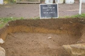
NPS/VAFO June 23-27, 2009 A Lesson in Stratigraphy
This week we had a lot of interesting things going on in the ground in terms of the soils and sediments we’re encountering, so it seems like an appropriate time for a quick lesson in how we “read” and understand the various layers we dig through.
Stratigraphy is the study of soil layers. We use it to aid us in what we call “relative dating,” which means studying the various layers and the features that cut across them and determining the order in which things were deposited. For example, in the very simplest of stratigraphic deposits, the layer on the bottom is the oldest, and will contain the oldest objects, and the layer on the top is the youngest, therefore containing the most recent objects, or at least objects that were deposited more recently.
Excavation unit G featured some particularly interesting stratigraphy, and provides an excellent example of how archaeologists “read” the soil. The important layers (or “strats”) in this unit were: 1) a dark layer of soil that marks the modern surface and consists of a fill- a soil that has been redeposited from somewhere else; 2) a yellowish layer consisting of redeposited subsoil; and 3) another dark layer that represents a plow zone- a layer of soil churned by plowing. This plow zone represents plowing done before the Headquarters building was constructed, so the top of it is actually an 18th century ground surface.
As you can see above, the layers are very clearly defined – they are separate deposits from separate times in history. The yellow layer, which is also considered to be a fill, consists of subsoil that was probably redeposited during a construction episode. It is soil that was dug up from somewhere nearby and redeposited in the area where we encountered it. It is most likely that the building episode in question was from the construction of Potts House itself, or the digging of the well behind it, because a trash pit which is clearly from the time of the Continental Army encampment cuts through this yellow soil. Because the trash pit cut across the yellow soil, we know that it was dug after the yellow soil was already in place, meaning that the yellow soil was at or very near the surface during the encampment period. Below the yellow layer is the plow zone. This layer runs all the way up to the wall of the house, so we know that it is related to plowing that happened before the house was built, as people wouldn’t have actually plowed so close to the building. So simply by looking at the various soil layers and features in this unit, we can deduce the following history of this part of the site:
1) The area was plowed and cultivated. 2) The house was built, and plowing in this particular area ceased. 3) Sometime during or after the construction of the house, but before or during the encampment period, a layer of yellowish subsoil was laid down. 4) During Washington’s occupation of the site, a trash pit was dug though the yellow soil, which was the ground surface at the time. 5) Sometime after the encampment period, another layer of fill was deposited.
As you can see, it is not only from the artifacts, but also from the soil itself that we learn the story of the landscape; however the artifacts that we recover from the various layers help us to identify what time periods and activities those layers represent. For example, we know that the trash pit is a trash pit because of the items found in it, such as the broken pottery, as well as a great deal of animal bone, which represents food waste. We know what time period it dates from because we recovered very fancy Revolutionary War-period ceramics (the kind of stuff that only Washington and his officers would have used), a polished bone-handled knife typical of the period, and a “double-D” buckle (the first specifically military object we’ve found to date, and the one which therefore told us that the trash pit definitely related to General Washington’s occupation of the site). 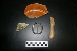
NPS/VAFO Stratigraphy is just another of many factors archaeologists have to take into account when attempting to analyze and interpret a site. Where objects are found in the soil, as well as where they are found in relation to one another, are important clues we use to determine how a site was used, as well as how the site landscape has changed through time (a concept that we refer to as “site formation,” which helps us understand how a site has changed from an active landscape to what we see in the ground today). Sometimes there is no simple way to explain what the stratigraphy of a site means to a trained eye, but archaeologists teach themselves to constantly think about how each object and layer of soil came to be where it was found, and each artifact or layer is considered to be an integral piece of the puzzle. The more pieces we can fit together, the more a clear picture emerges of what happened on the site in the past, and we can pass this picture on to those who may study the site in the future. 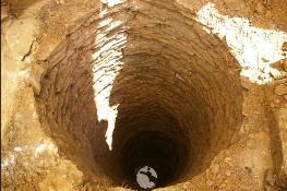
NPS/VAFO June 30-July 3, 2009 A Lesson in Record-Keeping
For our entry this week, we wanted to focus on how important it is to keep good records of our excavations. In fact, record-keeping is the archaeologist’s most important job. It is how we understand past investigations at a site, and how we provide future scholars with our excavation data, as well as our analysis and interpretations of our own work, in order to give them the most complete picture we can of the site. It must be remembered that archaeology is a destructive process- when we excavate a site, we are literally taking it apart, and we can never put it back together exactly like it was. This means that we must meticulously record all of our observations so that we preserve as much information about the site as possible, and can at least “put it back together” on paper, if not in reality.
For example, this week we discovered a well and a foundation wall, both of which had been seen before by other archaeologists, during the 1973 and the 1986 excavations respectively. However, if we didn’t have the reports left behind from those two investigations, we certainly wouldn’t have expected such large features. Happily, it wasn’t just the big features which were noted in those reports and maps – the archaeologists drew everything that they saw on a map, from the top of one of our 18th century trash pits to the late 19th century drainpipes. It is imperative that these maps be very accurate and to scale – with the use of the maps and their reference point (the “datum” – the fixed point on a site from which all measurements are taken, and to which they all relate), we were able to correctly predict in which squares we would find certain features, like the well pictured below, which we knew would be in excavation unit H. The reports we are consulting regarding the well, however, are draft reports; they are not as complete as full reports would have been, and because final analyses and interpretations still needed to be made at the time the drafts were written, they lacked some of the photographs and expanded text that we would like to have had. For example, the excavation report definitely showed us where the 20 foot deep well was, but it did not mention how much had been excavated, or that there was a concrete cap placed over the opening when the excavation was finished. Through the archaeology, we discovered both of these things, and we were able to adequately deal with them thanks to the “heads-up” that the report gave us.
Field journals are often kept on sites as a way to actively and immediately record everything that is occurring on any given day. They help us express our ideas about and impressions of the site without writing them in any official report; that way we can reference ourselves later, and decide whether we’d been on the right track, or whether we’d changed our minds about any of our preliminary conclusions. When thinking about the well mentioned above, we were able to reference some of the field notes from the 1973 excavations to help us fill in some of the gaps left in the draft report from that dig. Along with journals, technical drawings and photographs of the site are important records that must be kept. But we don’t only look at records kept by archaeologists; we seek out any records that might help us tell the story of a site. For example, one of the reasons we are able to make heads or tails of the numerous features from the various time periods is because we have photographs from the early 20th century showing additions to the house while they were still standing. Finally, pieces like this blog will become part of the permanent record of the site.
Our ideas about what we’re finding, and the way in which we explain it to you, the public, are all important additions to the history of the site; those ideas are informed by the past reports as well as by the present archaeology, and the ideas themselves will influence and shape our own official conclusions as we work through them in the public eye. Please stay tuned; only one week of fieldwork remains, and though we may have an idea of what we might find (from our previous records and observations), there is no guarantee that our expectations might be met in quite the way we anticipate they will, and new surprises await us with each shovel-full of soil. 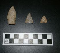
NPS/VAFO July 6-10, 2009 Site location and multi-component sites
The main focus of the excavations this summer has been to find artifacts and features relating to the historic period occupation of the site- specifically, the period of General Washington’s occupation of the house during the Revolutionary War encampment. However, the excavations have also produced evidence of the use of the site during other time periods. The house was occupied as a private residence both before and after Washington’s stay there, and the archaeology reflects this. We have even recovered clues to how the site has been used since it has become part of a park! Although we may mainly be interested in the encampment period, it is important that we not ignore the other occupations represented. We want to tell the whole story of the site- not just the part relating to the American Revolution. Even those things that happened at the site after the encampment may be of interest to future researchers, so we must record everything we find with equal care.
Archaeologists refer to sites that contain evidence of occupation during more than one time period as multi-component sites. It is common to find sites that contain, at minimum, occupation from the two basic periods into which we often divide the past; the historic period and the prehistoric period. Put simply, the historic period covers time for which written records exist, and the prehistoric period refers to times for which there are no written records. In eastern Pennsylvania, the prehistoric period covers the time when Native Americans were the only humans on the landscape (starting about 13,000 years ago), and ends with the arrival of European colonists in the early 1600’s, which ushers in the historic period.
The Washington’s Headquarters site is a multi-component site containing evidence of both historic and prehistoric occupations. In addition to the many historic period artifacts and features, we have also recovered evidence of Native American occupation probably dating back to at least 4000 years ago! The photo above shows some of the prehistoric artifacts we have found. The stemmed point on the left dates to the Late Archaic period (approx. 3000 – 1000 B.C.), and the triangular points on the right are typical of the Late Woodland period (approx. 1000 – 1600 A.D.). Only the triangles are “true” arrowheads, the bow and arrow not having come into use in this part of the world until around 1500 years ago, whereas the stemmed point is more likely a spear tip and/or knife.
Is it just a coincidence that the 18th century house that served as Washington’s Headquarters happens to have been built on an earlier Native American site? Not at all! The historic period occupants of the site chose this location for the same reasons that their prehistoric predecessors did. The site is located on flat, well-drained ground at the confluence of two streams- Valley Creek and the Schuylkill River. This type of location was as important to people in the 1700’s as it was to earlier Native American populations. It is simply a good place to live, regardless of the time period in question. This type of situation- a multi component site with both prehistoric and historic occupations- is not at all uncommon in archaeology, and demonstrates how important archaeology is in helping us to understand basic aspects of human behavior that apply to people all over the world and in all time periods. It also shows why archaeologists must train themselves to be able to excavate and interpret any artifacts and features that they may encounter on a site, no matter what time period they are from. The End! Having had a very successful field season, finding several thousand artifacts and some exciting features dating to General Washington’s occupation of the site, we’ve now closed the excavations for the year. Before backfilling the site, we lined the bottom of the excavation with a sturdy geotextile fabric, which will mark the point where we stopped digging as well as protect the foundation walls we uncovered. This way, future archaeologists who may want to open the site back up will be able to see exactly what we saw at the end of our excavation. Additionally, we kept iron spikes in the ground at the corners of our excavation block so it will be easy to relocate in the future. Now that we’ve stopped digging, we’ve spent the last several weeks in the laboratory, processing the objects we recovered from the excavations. The first step is, of course, washing the artifacts. Each object must be carefully cleaned before we analyze it and get it ready to be stored. This is sometimes rather tedious work, but often we notice things about the artifacts when we clean them that we didn’t see when they came out of the ground, so it is often during this process that we learn a lot more about the site and begin to refine our interpretations of what we found. After the artifacts are cleaned, they must be cataloged. During cataloging, each object is meticulously recorded, and we write down exactly what it is and where in the site it came from. Sometimes there are several very similar artifacts from the same part of the site. For example, Level 3 of excavation unit “E” may have contained 14 pieces of broken window glass. We call this a “lot” and catalog all of the pieces together. Each artifact, or “lot”, is given a unique catalog number, and that number tells us where to look in the master catalog to see all of the information about that artifact (such as where on the site we found it, what condition it is in, and all of the other information we recorded about it). When all the cataloging was done, we had over 2000 catalog numbers, and, because some of these represent “lots” that contain more than one object, you can imagine how many individual artifacts this represents! After cataloging, we must label the artifacts. Each object that is large enough will have its catalog number written on it so that we always know where to look in the master catalog to find all of the information we recorded about it. This allows us to separate individual objects from the rest of the collection, because we will know exactly where to put them back when we’re done with them. We often do this if we want to put a particular object on display. If you look closely next time you are at a museum, you may see tiny numbers written on some of the objects on display, and this is what they are for. It also sometimes happens that we have several pieces of the same object that were found in different areas of the site. For instance, this summer we found many pieces of a hand-painted porcelain teapot from General Washington’s time, but all the pieces didn’t come from the same place on the site. We want to glue all the pieces back together so we can see what the teapot looked like, but we want to keep track of where each individual piece came from. Therefore, we have to label each piece with its catalog number before we begin to glue them back together. Once the labeling is complete, we will proceed with analyzing everything we found. Part of this will involve gluing things like the teapot back together, which we call “mending” artifacts. We will also do things like study the artifacts from each layer of soil we excavated and determine when they were made, which we can often do by looking at how they were made and how they were decorated. This will allow us to figure out what time period each layer of soil dates to. We will also look at what types of artifacts were found in each layer, and what this says about the people who were at the site and what they were doing there. For instance, the “fancy” and expensive ceramics we found in the layers dating to the Revolutionary period tell us that they probably represent the occupation and use of the site by General Washington and his officers. Another type of analysis we might do involves looking at all of the food bone we found and seeing what types of animals it came from and what particular cuts of meat from those animals. This tells us about what was being eaten by the people living at the site, and allows us to compare it to what people on other sites from the same time period were eating. We certainly expect to see evidence that General Washington was eating a much different diet than most of his enlisted soldiers, and we will be able to prove this by comparing the food bone we found this summer to that found in excavations at regular soldiers’ huts. Not only do we have to analyze the artifacts, but we also have to carefully look back over all of the records we kept while in the field excavating. We will look at which artifacts came from each layer of soil and see how the various layers relate to one another. It is also at this point that we may begin to see differences in the types of artifacts recovered from different areas of the site, and to interpret what that means. This is when we really start to be able to tell the whole story of the site- when we look at everything all together- the artifacts, what they are, where they came from, and how and why they came to be deposited where we found them. All of this information will eventually be put together into a final report which will tell about what we found and what we think it means. This way, anyone in the future who is interested in General Washington’s stay at Valley Forge, or anything else that happened at the Headquarters site, will be able to look at our report and see what we did and what we learned from it. After all, this is ultimately why we do archaeology- so that we can not only learn about the past, but also preserve and share that knowledge with others. |
Last updated: August 31, 2022
