Courtesy of Inland Sea Productions Recycling EarthEarth’s geology moves at an imperceptibly slow pace. Except for catastrophic events such as volcanoes, floods, and earthquakes, today's landscapes require millions of years to form. Geology is created in many different ways. Tectonic plates constantly shift along fault lines creating mountains and valleys. Volcanoes erupt creating new land. The Earth's climates change due to its wobble on the axis and its relationship to the Sun's warmth. Climate affects geology by freezing, thawing, eroding, and depositing landscapes by way of wind and precipitation. Glaciers freeze and thaw affecting the depth of the oceans and the land that it covers. 
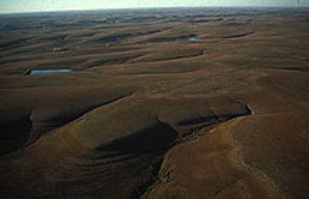
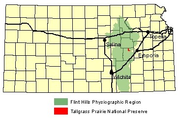
Courtesy of Kansas Geological Survey Tallgrass Prairie National Preserve is located in the heart of the Flint Hills region of Kansas. This physically geographic region extends from the Nebraska state line southward into northern Oklahoma and is from 30 to 100 miles wide. The hills are usually flat topped with concave slopes that have developed on the underlying limestone and shale layers. The Flint Hills are characterized by thin soils, limestone outcrops, vegetation-covered shale intervals between the limestones, deeply incised valleys, and dissected topography. Many of the limestones contain nodules and layers of flint, a type chert. Flint is a hard, dense rock that resists erosion. As the limestones erode, angular fragments of flint accumulate at the surface, giving the Flint Hills their name. Diving into the PastKansas was once the bed of a vast shallow body of water called the Permian Sea. During this extensive period, the earth’s oceans rose and fell many times creating different types of aquatic environments. It's difficult to imagine the prairie grass as the mucky bottom of an inland sea, but this was 250 million years ago. We would need boats rather than automobiles to get around. If humans were around, fishing would have been the main economy instead of agriculture. Tallgrass Prairie National Preserve offers us all an opportunity to study this amazing prehistoric past up close (and on dry land). 
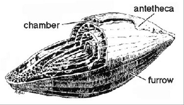
Courtesy of Kansas Geological Survey Lithify and FossilizeThe shallow warm seas supported enormous populations of invertebrates, fish, amphibians and plants. These creatures took calcium carbonate (CaCO3) out of the water and secreted it, forming shells or skeletons. As these organisms died, they sank to the sea floor where the organic parts decayed. The harder calcium carbonate accumulated and lithified into limestone. Clay and mud deposits lithified into shale. The limestone and shale sediments seen in the Flint Hills show us a cross section of a different landscape long ago. Most of the marine fossils found here are invertebrates - animals without backbones: Corals, clams, snails, bryozoans (colonies of animals resembling sea fans), sea urchins, crinoids (a stalked animal that is distantly related to the starfish and sea urchin), and clam-like animals called brachiopods. Particularly abundant in some limestones are fusulinids - fossils shaped like wheat grains. These one-celled animals floated in the warm tropical water. When they died, their skeletons were preserved in the lime mud of the ocean floor. Fusulinids can be seen in many of the limestone blocks used for building on the preserve. Flint, a type of chert, can occur within limestone as roughly spherical concentrations (nodules) or less commonly as layers (laminated). Some geologists believe flint nodules precipitated from volcanic ash which hardened in the cracks of limestone. Others theorize flint may form from the remains of marine organisms rich in silica. The remains fell to the ocean floor, then migrated together as the limestone formed. The layers of chert may have formed as the silica material recrystallized, chemically replacing the limestone. 
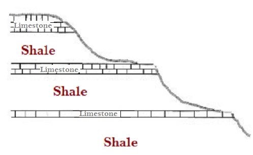
Courtesy of Kansas Geological Survey Differential ErosionLimestone ranges in color from nearly white to brown. It is harder and more erosion resistant than the shales which are usually gray or tan. The alternating beds of limestone and shale produce terraced hillsides. Many of the limestone layers create notable benches on the hillsides. The shales form steep slopes between the benches. The hills themselves are created by a process called differential erosion. Tougher limestones and flints cap the tops of the hills. The land between erodes away faster. The limestone and shale beds were deposited during the Permian Period of geologic history, about 280 million years ago. At that time, the climate here was hot. The surface was covered by water most of the time. The limestones represent periods when the region's surface was covered by shallow, tropical oceans which teemed with life. Shales represent times when mud was deposited on the ocean floor. Each of these sedimentary rock layers has been named after towns, creeks, or other nearby landmarks; the names are based on the locations where each rock layer was first found and described by geologists. CultivationFew places in the country demonstrate the connection between landscapes and people better than the tallgrass prairie of the Flint Hills. The surrounding area are shaped by the rocks that lie directly beneath the vegetation and soil. These same rocks made cultivation difficult and led to the use of native prairie grasses for ranching. This rocky terrain is closely tied to today's ranching culture. The thin, rocky soils and steep slopes of the Flint Hills have precluded cultivation, effectively preserving the native grasslands. Historically, only deep ravines and the flood plain of streams were forested. Most cultivation is limited to river and stream bottoms, such as along Fox Creek, just east of the ranch headquarters area. There, the bedrock is covered by a layer of river-deposited sediments which developed thick soils especially valuable for cultivation. Read More About Geology at the Preserve |
Last updated: March 5, 2022
