
Library of Congress Fort Harrison was key to General Butler's plan of attack. It represented the strongest point on the Confederate line of defenses. From it, one could see all the way to the James River. However, in 1864 most of the Confederate forces were in Petersburg and here the Confederate defenders numbered barely 200. Their guns were mostly so poor as to be scorned by the main field artillery. The Union attack pierced the fort quickly, with relatively few casualties. Had the Union attacks on the rest of the Confederate line succeeded as well as at New Market Heights and Fort Harrison, the overall military significance would have been greater. On September 30, Robert E. Lee personally organized a major effort to recapture the lost fort. His attack also lacked coordination, and the well prepared Union defenders-some of them armed with multiple shot weapons crushed the Confederate effort and inflicted great loss on the attackers. The victors abolished the Confederate title for the fort and renamed it Fort Burnham after the Union general killed in the attack of September 29. Walking Tour of the Fort 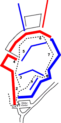
NPS STOP 1 -- You are facing the side gate of Union Fort Burnham. The short wall to your left and the portion of the earthworks visible immediately to your right were added by the Federal defenders after their capture of Fort Harrison. These walls protected the defenders in the event of a Confederate attack, and shielded them from a daily harassing fire delivered by Confederate guns north of here. STOP 2 -- Stay on the path to the left as you enter the fort. These earthworks make up the primary wall of Confederate Fort Harrison and are an extension of the exterior line of Richmond defenses. The height of this wall was 18-27 feet, and up to 15 feet wide. Beyond the wall is a deep ditch that discouraged attacks. STOP 3 -- The freestanding wall on your right is a traverse. It was built by Federal defenders as an inner wall to deflect artillery shells fired from Fort Johnson and Fort Gilmer to the north. STOP 4 -- The rectangular space in front of you was one of three Confederate artillery positions inside the fort. The other sections are not clearly visible because of alterations made by Union troops after the battle. On September 29, Federal troops first entered the fort over the wall on your left. This section was considerably weakened when two large artillery pieces became inoperable. The solid mass of earth to the right was called the Great Traverse, and was constructed by Confederate engineers as protection from artillery shells fired from Union gunboats on the James River. STOP 5 -- To your right is another traverse, the largest in the fort. To your left, beside the Great Traverse, is the trace of an original road-way that was constructed after the battle to provide Union troops with full access to the fort. In this vicinity on September 29, General Grant narrowly escaped death when a Confederate shell exploded nearby, showering him with dirt. STOP 6 -- This marks the abrupt end of Fort Harrison. The remaining walls to your right and front were built by Union troops as part of Fort Burnham. The Confederate walls are more substantial because the builders had two years in which to improve the position, while the Union walls were created in a few days with hostile Confederates in sight. STOP 7 -- The guard rail encloses the location of a fresh water well, dug by Confederates and retained by the Federals after the battle. Union troops feared that the Confederates knew the location of the well, and they built a small traverse beside it as protection from Confederate artillery fire. STOP 8 -- To the left is an emplacement for artillery called a barbette, built by Federal troops after the fighting. An artillery piece could be rolled up the ramp into position near the angle in the fort wall with its barrel projecting over the top of the wall. This provided little protection for the crewmen operating the piece, but gave the gun a wider angle of fire. STOP 9 -- Along this wall are the remnants of Federal bombproofs, used to protect soldiers from shells and stray bullets. |
Last updated: February 26, 2015