National Park Service LogoU.S. Department of the InteriorNational Park ServiceNational Park Service
National Park Service:  U.S. Department of the InteriorNational Park Service Arrowhead
Pony Express National Historic Trail Mud Spring relay station was located near this historical marker in western Nebraska.
view map
text size: largest larger normal
printer friendly
Pony Express National Historic Trail
Auto Tour Route - Nevada
Below are driving directions to follow the Pony Express National Historic Trail west through Nevada, from Utah to California. A simple map showing the general route is below the directions.

 From the Utah - Nevada state border:

1. Take Interstate 80 west to U.S. Route ALT 93.
2. Turn south onto U.S. Route ALT 93.
3. Take U.S. Route ALT 93 south to U.S. Route 93.
4. Take U.S. Route 93 south to U.S. Route 50.
5. Turn west onto U.S. Route 50 at Ely.
6. Take U.S. Route 50 west though to Carson City and California.

Total original route miles in Nevada: 404
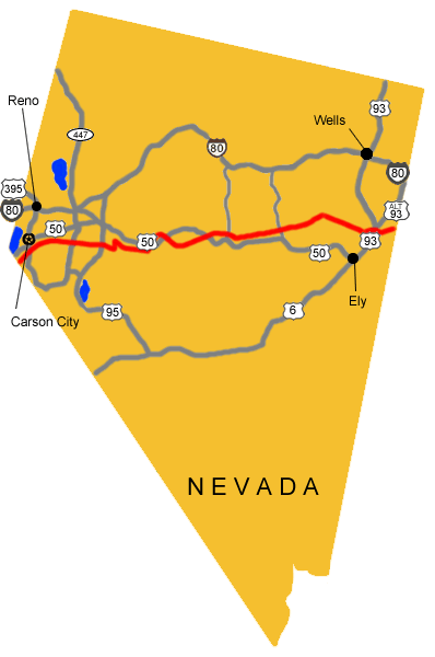
 
Map image showing the auto tour route driving directions across Nevada.
NPS Image
Map image showing the auto tour route driving directions across Nevada.

You are exiting the National Park Service website

Thank you for visiting our site.

You will now be redirected to:

We hope your visit was informative and enjoyable.

Simpson Springs Pony Express Station in the Utah west desert.

Did You Know?
Pony Express riders and Overland Stage passengers found a good source of water at Simpson Springs Station as they crossed the west desert of Utah.
more...

Last Updated: December 05, 2011 at 11:31 MST