National Park Service LogoU.S. Department of the InteriorNational Park ServiceNational Park Service
National Park Service:  U.S. Department of the InteriorNational Park Service Arrowhead
Pony Express National Historic Trail Mud Spring relay station was located near this historical marker in western Nebraska.
view map
text size: largest larger normal
printer friendly
Pony Express National Historic Trail
Auto Tour Route - Kansas

Below are driving directions to follow the Pony Express National Historic Trail west through Kansas, from Missouri to Nebraska. A simple map showing the general route is below the directions.

From St. Joseph, MO:

1. Take U.S. Route 36 west to State Route 148.
2. Turn north onto State Route 148.

From Atchison, KS:

1. Take U.S. Route 73 west to State Route 9.
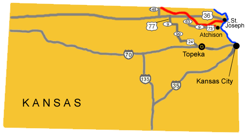
2. Turn west onto State Route 9.
3. Take State Route 9 west to State Route 63.
4. Turn north onto State Route 63.
5. Take State Route 63 north to U.S. Route 36.
6. Turn west onto U.S. Route 36.
7. Take U.S. Route 36 west to State Route 148.
8. Turn north onto State Route 148.

Total original route miles in Kansas: 139
 
Map image showing the auto tour route driving directions across Kansas.
NPS Image
Map image showing the auto tour route driving directions across Kansas.

You are exiting the National Park Service website

Thank you for visiting our site.

You will now be redirected to:

We hope your visit was informative and enjoyable.

Hollenberg Station near Marysville, Kansas

Did You Know?
Hollenberg Station served as the last Pony Express stop in Kansas as riders traveled west to Sacramento during the 19 month period between April 1860 and November 1861.
more...

Last Updated: December 05, 2011 at 11:31 MST