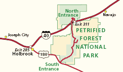
NPS Entering the ParkPetrified Forest National Park stretches north and south between Interstate 40 and Highway 180. There are two entrances into the park. Your direction of travel dictates which entrance is more convenient: 
NPS Petrified Forest National Park is located in northeastern Arizona, about 50 miles from the New Mexico border on Interstate 40. There is no public transportation to or within the park. By PlaneNearest major airports are in Phoenix, Arizona and Albuquerque, New Mexico. There are also smaller airports in Flagstaff and Show Low, Arizona and Gallup, New Mexico. From the airport, you may want to rent a car to drive to the park. For private planes, there is a small airport located in Holbrook, Arizona. By Private VehicleFrom the north and west side of greater Phoenix travel Interstates 17 North and 40 East, passing through Flagstaff (259 miles). From eastern side of greater Phoenix travel Highways 87 North to Payson, 260 East to Heber, 377 North to Holbrook, and 180 South to the park (215 miles). Driving from Albuquerque travel 204 miles west on Interstate 40 to Exit 311. 
NPS GPS CoordinatesIn this area, a regular map is better than using GPS. GPS doesn't understand the nuances of backroads and vast landscapes with locked gates. The park has two entrances, one off of I-40, the other from Hwy 180, both with obvious entrances.Be aware that some apps outside of NPS.gov don't always accurately locate sites within the park. One app actually places the headquarters in a remote wash out in the backcountry. Please be careful in using GPS units to find our park! Rainbow Forest Museum (South Entrance) |
Last updated: September 24, 2023
