|
NATIONAL PARK SERVICE
The National Parks: Index 2009–2011 |

|
|
| Touro Synagogue National Historic Site |
Part 3:
Related Areas
| Affiliated Areas |
In the Act of August 18, 1970, the National Park System was defined in law as “any area of land and water now or hereafter administered by the Secretary of the Interior through the National Park Service for park, monument, historic, parkway, recreational or other purposes.” The same law specifically excludes “miscellaneous areas administered in connection therewith,” that is, those properties that are neither federally owned nor directly administered by the National Park Service but that the National Park Service assists. The Affiliated Areas comprise a variety of locations in the United States and Canada that preserve significant properties outside the National Park System. Some of these have been recognized by Acts of Congress, others have been designated national historic sites by the Secretary of the Interior under authority of the Historic Sites Act of 1935. All draw on technical or financial aid from the National Park Service. |
|
Aleutian World War II |
This area preserves lands owned by the Ounalashka Corporation on the island of Amaknak. It provides for the interpretation of the unique and significant circumstances involving the history of the Aleut people and the role the Aleut people and the Aleutian Islands played in the defense of the United States in World War II. Authorized Nov. 12, 1996. Acreage—81, all nonfederal. | |
|
American Memorial Park |
This site on the island of Saipan in the Northern Mariana Islands was created as a living memorial honoring the sacrifices made during the Marianas Campaign of World War II. Recreational facilities, a World War II museum, and a flag monument keep alive the memory of over 4,000 U.S. military personnel and local islanders who died in June 1944. Authorized Aug. 18, 1978. Acreage—133, all nonfederal. | |
|
Benjamin Franklin |
In the Rotunda of the Franklin Institute the colossal seated statue of Franklin, by James Earle Fraser, honors the inventor-statesman. Designated Oct. 25, 1972. Owned and administered by the Franklin Institute. Acreage—0.00. | |
|
Chicago Portage |
A portion of the portage between the Great Lakes and the Mississippi, discovered by French explorers Jacques Marquette and Louis Joliet, is preserved here. Designated Jan. 3, 1952. Administered by Cook County. Acreage—91.20, all nonfederal. | |
|
Chimney Rock |
Pioneers camped near this landmark, which stands 500 feet above the Platte River along the Oregon and California trails. Designated Aug. 2, 1956. Owned by Nebraska; administered by the city of Bayard, the Nebraska State Historical Society, and the National Park Service under a cooperative agreement of June 21, 1956. Acreage—83.36, all nonfederal. | |
|
Fallen Timbers Battlefield |
The sites preserve and interpret U.S. military history and American Indian culture between 1794 and 1813. In 1794 Gen. Anthony Wayne and Shawnee Chief Tecumseh defeated a British-supplied federation of seven tribes along the Maumee River, securing Ohio and the Northwest Territory for U.S. settlement. Fort Miamis was later the site of a battle in the War of 1812. Established December 9, 1999. Acreage: 185, all nonfederal. | |
|
Father Marquette |
The memorial pays tribute to the life and work of Father Jacques Marquette, French priest and explorer. It is located in Straits State Park near St. Ignace, Mich., where Marquette founded a Jesuit mission in 1671 and was buried in 1678. Authorized Dec. 20, 1975. Acreage—52, all nonfederal. | |
|
Gloria Dei (Old Swedes’) |
This second oldest Swedish church in the United States was founded in 1677. The present structure, a splendid example of 1600s Swedish church architecture, was erected about 1700. Designated Nov. 17, 1942. Church site owned and administered by Corporation of Gloria Dei (Old Swedes’) Church. Boundary change: Aug. 21, 1958. Acreage—3.71 Federal: 2.08 Nonfederal: 1.63. | |
|
Green Springs |
This portion of Louisa County in Virginia’s Piedmont is noted for its concentration of fine rural manor houses and related buildings in an unmarred landscape. In 1974 the district was declared a national historic landmark by the Secretary of the Interior. NO PUBLIC FACILITIES. On December 12, 1977, the Secretary agreed to accept preservation easements for nearly half of the 14,000 acres in the district. Acreage—14,003.97 Federal (easements): 5,766.04 Nonfederal: 8,237.93. | |
|
Historic Camden |
This early colonial village was established in the mid-1730s and was known as Fredericksburg Township. In 1768 the village was named Camden in honor of Charles Pratt, Lord Camden, a British Parliamentary champion of colonial rights. The site was occupied by the British under Lord Cornwallis from June 1, 1780, until May 9, 1781. Camden was one of the few frontier settlements where two Revolutionary War battles were fought: August 16, 1780, and April 25, 1781. Authorized May 24, 1982. Acreage—undetermined. | |
|
Ice Age |
This reserve contains nationally significant examples of landforms resulting from continental glaciation. Each of the nine units is state-owned and managed as a park recreational area, natural area, or wildlife area. Authorized Oct. 13, 1964. Acreage—32,500, all nonfederal. | |
|
International Peace Garden |
Peaceful relations between Canada and the United States are commemorated here. North Dakota holds the 888-acre U.S. portion for International Peace Garden, Inc., which administers the area for North Dakota and Manitoba. Originated by North Dakota in 1931; federal aid authorized in acts of Oct. 25, 1949; June 28, 1954; Aug. 28, 1958; Oct. 26, 1974. Acreage—2,330.30, all nonfederal. | |
|
Inupiat Heritage Center |
This center is affiliated with New Bedford Whaling National Historical Park to commemorate over 2,000 whaling trips from New Bedford to the western Arctic in the 1800s. The center collects, preserves, and exhibits historical material, art objects, and scientific displays. Designated Feb. 3, 1999. Acreage—undetermined. | |
|
Jamestown |
Part of the site of the first permanent English settlement in North America (1607) is on the upper end of Jamestown Island, scene of the first representative legislative government on this continent, July 30, 1619. Designated Dec. 18, 1940. Owned and administered by Association for the Preservation of Virginia Antiquities. Adjacent areas of the historic Jamestown site and island are part of Colonial National Historical Park. Acreage—20.63, all nonfederal. | |
|
Kate Mullany |
Catherine A. (Kate) Mullany was an Irish immigrant laundry worker who organized and led Troy’s Collar Laundry Union during the 1860s, one of the first all-female unions in the United States. She lived in this house at 350 8th Street, Troy, N.Y., from 1869 to 1875, inherited the house when her mother died in 1876, moved away, returned in 1903, and died here in 1906. The house was privately owned until 2003, when it was purchased by the New York AFL-CIO on behalf of the American Labor Studies Center. Authorized Dec. 3, 2004. Acreage—.06, all nonfederal. | |
|
Lower East Side Tenement |
The heart of the Lower East Side Tenement Museum is its landmark tenement building, home to over 7,000 people from 20 nations between 1863 and 1935. The museum promotes tolerance and historical perspective at this gateway to America. Designated Nov. 12, 1998. Acreage—undetermined, all nonfederal. | |
|
New Jersey Coastal |
From the Raritan Bay near New York City south to the Delaware River and Bay, this scenic vehicular trail explores the diverse heritage of the New Jersey coast. Lighthouses, boardwalks, historic communities, and migratory flyways are part of the trail. There are fees for some activities sponsored by private and public institutions. Authorized Oct. 20, 1988. Acreage—undetermined. | |
|
Oklahoma City |
The bombing of the Alfred P. Murrah Federal Building on April 19, 1995, killed 168 people and injured over 650. The memorial is owned and operated by a private foundation. The National Park Service provides interpretive services on the Outdoor Symbolic Memorial. Established Oct. 9, 1997; redesignated as affiliated area Jan. 23, 2004. Acreage—6.24 Federal: 3.12 Nonfederal: 3.12. | |
|
Pinelands |
The Pinelands (Pine Barrens) is a unique ecosystem of historic villages and berry farms amid vast pine-oak forests, extensive wetlands, and diverse species of plants and animals. It is protected by state and federal legislation through management by local, state, and federal governments and the private sector. Public recreation facilities are provided within state parks and forests. Pinelands was the nation’s first designated national reserve. Authorized Nov. 10, 1978. Designated a Biosphere Reserve 1983. Acreage—1,164,025 Federal: 90,530 Nonfederal: 1,073,495. | |
|
Port Chicago Naval |
This memorial, located at the Concord Naval Weapons Station near Concord, Calif., recognizes the critical role Port Chicago played in World War II by serving as the main facility for the Pacific Theater. It also commemorates the explosion that occurred at the Port Chicago Naval Magazine on July 17, 1944, which resulted in the largest domestic loss of life during World War II. NOT OPEN TO THE PUBLIC. Authorized Oct. 28, 1992. Acreage—undetermined. | |
|
Red Hill Patrick Henry |
The law office and grave of the fiery Virginia legislator and orator are preserved at this small plantation along with a reconstruction of Patrick Henry’s last home, several dependencies, and a museum. Authorized May 13, 1986. Acreage—117 acres, all nonfederal. | |
|
Roosevelt Campobello |
President Franklin D. Roosevelt was stricken by poliomyelitis here at his summer home in New Brunswick, Canada, at the age of 39. Established July 7, 1964. Owned and administered by a U.S.-Canadian commission. Acreage—2,721.50, all nonfederal. | |
|
Sewall-Belmont House |
Rebuilt after fire damage from the War of 1812, this red brick house is one of the oldest on Capitol Hill. It has been the National Woman’s Party headquarters since 1929 and commemorates the party’s founder and women’s suffrage leader, Alice Paul, and associates. OPEN ON A LIMITED BASIS. Authorized Oct. 26, 1974. Acreage—0.35, all nonfederal. | |
|
Thomas Cole |
This is the Hudson River home of the eminent British-American landscape painter Thomas Cole (1801–1848). He is recognized as the founder of the Hudson River School, America’s first indigenous school of landscape painting. Cole created some of his greatest paintings, including the “Voyage of Life” series, in the small studio on the property. He lived in the 1815 Federal-period house. Owned and operated by the Greene County Historical Society. Authorized Dec. 9, 1999. Acreage—3.4, all nonfederal. | |
|
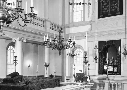
Touro Synagogue |
One of the finest examples of colonial religious architecture, designed by Peter Harrison, this synagogue is the present-day place of worship of Congregation Jeshuat Israel. Designated March 5, 1946. Owned by Congregation Shearith Israel, New York City. Acreage—0.23, all nonfederal. | |
| National Heritage Areas |
National Heritage Areas expand on traditional approaches to resource stewardship by supporting large-scale, community centered initiatives that connect local citizens to the preservation, conservation, and planning processes. Through the facilitation of a local coordinating entity, like a private non-profit corporation or a public commission, residents of a region come together to improve regional quality of life by protecting their shared cultural and natural resources. In National Heritage Areas, businesses, governments, non-profit organizations, and private individuals collaborate to promote sustainable economic development and community revitalization projects. This cooperative approach allows National Heritage Areas to achieve both conservation and economic growth in ways that do not compromise local land use controls. Participation in projects and programs is always voluntary, with zoning and land-use decisions remaining under the jurisdiction of local governments. National Heritage Areas are designated by Congress. Each National Heritage Area is governed by separate authorizing legislation and operates under provisions unique to its resources and desired goals. The National Park Service provides technical planning and limited financial assistance. Serving as a partner and advisor, the National Park Service leaves decision-making authority in the hands of local people and organizations. First inaugurated in 1984, National Heritage Areas encompass 40 regions, ranging from factory towns and city neighborhoods to farmland and battlefields. As part of a living, working, evolving landscape, National Heritage Areas reflect the diverse and evolving histories and cultures of the people who call the region home. Visitors who explore these special places will learn about an innovative approach to resource protection; they will also gain insight into the physical character and cultural legacy of the United States. |
|
Abraham Lincoln |
Here, in this 42-county region of central Illinois, are courthouses, log cabins, hotels, and homes where Lincoln argued cases and entertained neighbors and friends for over 30 years. Authorized May 8, 2009. | |
|
Arabia Mountain |
Located in parts of three counties east of Atlanta, Ga., the region has active quarries, rolling topography, rural landscapes, and unique granite outcroppings. Authorized Oct. 12, 2006. | |
|
Atchafalaya |
This treasury of nature, culture, and history in south-central Louisiana encompasses the nation’s largest river swamp. While the 14 parishes that compose the heritage area are best-known for the Cajun descendants of French-speaking Acadians, the area’s complex racial and ethnic mix is reflected in distinctive architecture, music, language, food, and festivals. Authorized Oct. 12, 2006. | |
|
Augusta Canal |
This corridor in northeastern Georgia interprets a piece of our nation’s history that transformed Augusta into an industrial center on the eve of the Civil War. Authorized Nov. 12, 1996. | |
|
Automobile |
The area consists of six corridors representing the region that put the world on wheels. Auto-related museums, historical sites, and natural, cultural, and recreational resources link, protect, preserve, and interpret the automobile’s story. Authorized Nov. 6, 1998. | |
|
Baltimore |
Authorized March 30, 2009. | |
|
Blue Ridge |
The area of 25 counties in the Blue Ridge Mountains of North Carolina contains eastern America’s tallest mountain (Mt. Mitchell) and deepest gorge (Linville Gorge). The heritage area preserves Cherokee and Scotch-Irish culture, traditional mountain music, arts and crafts, and associated historic sites. Authorized Nov. 10, 2003. | |
|
Cache La Poudre |
The corridor encompasses the river and its flood plain from the Roosevelt National Forest to its confluence with the South Platte River in Colorado. This heritage area commemorates the contributions of the Poudre River to the development of water laws in the western United States and the evolution of complex water delivery systems. Authorized Oct. 19, 1996. | |
|
Cane River |
This area in Louisiana is a largely rural landscape known for its historic plantations, distinctive Creole architecture, and multi-cultural legacy. It is home to a blend of cultures, including French, Spanish, African, American Indian, and Creole. Authorized Nov. 2, 1994. | |
|
Champlain Valley |
Here are the linked navigable waterways and adjacent lands of Lake Champlain, Lake George, the Champlain Canal, and portions of the Upper Hudson River in Vermont and New York. This region, homeland of Indian people of Algonquin and Iroquois descent, played an important role in the establishment of the United States and Canada. Authorized Oct. 12, 2006. | |
|
Crossroads of the |
This area encompasses 213 municipalities and all or parts of 14 counties from Bergen to Gloucester in New Jersey. Gen. George Washington planned and led some of the most decisive military actions of the American Revolution across this landscape. Authorized Oct. 12, 2006. | |
|
Delaware and Lehigh |
This 165-mile region, rich in anthracite coal and other natural resources, is a transportation crossroads. Canals and railroads in the Delaware and Lehigh valleys transported lumber, hard coal, slate, iron, and steel from mountain to market, fueling America’s Industrial Revolution. Authorized Nov. 18, 1988. | |
|
Erie Canalway |
This heritage corridor commemorates and celebrates the impacts of the Erie Canal on the creation of the United States. The 524-mile canal system is an engineering marvel that knitted together New England, New York, and the West, spreading commerce and ideas. Authorized Dec. 21, 2000. | |
|
Essex |
The area encompasses 500 square miles of eastern Massachusetts. It includes thousands of historic sites, rivers and marshes, and miles of unspoiled coastline. The heritage area illuminates almost 400 years of our nation’s history. Authorized Nov. 12, 1996. | |
|
Freedom’s Frontier |
This area encompasses counties in eastern Kansas and western Missouri. Along this border, before and during the Civil War, a conflict took place between the forces of slavery and freedom. As abolitionists and others fought to keep Kansas a free state and pro-slavery forces gathered in Missouri, the Eastern press began calling the region “Bleeding Kansas.” Authorized Oct. 12, 2006. | |
|
Freedom’s Way |
Authorized March 30, 2009. | |
|
Great Basin |
The heritage route incorporates the classic landscape of White Pine County, Nev., Duckwater Shoshone Reservation, Nev., and Millard County, Utah. This region of biological diversity and fragile ecological communities has cultural sites and American Indian heritage. Highlights include the Nevada Northern Railway Museum and Fillmore Territorial Statehouse, Nevada, and Topaz Japanese Relocation Camp, Utah. Authorized Oct. 12, 2006. | |
|
Gullah/Geechee |
This area recognizes the important contributions made to American culture and history by Africans and African Americans known as the Gullah/Geechee who settled in the coastal counties of South Carolina and Georgia, the southeast coast of North Carolina, and the northeast coast of Florida. Authorized Oct. 12, 2006. | |
|
Hudson River Valley |
The heritage area stretches from New York City to Saratoga County, north of Albany. The area promotes and interprets resources that support three corridor-wide themes: the interrelationship of nature and culture, the vital roles of freedom and dignity throughout the valley’s history, and the historical and contemporary role of commerce. Authorized Nov. 12, 1996. | |
|
Illinois & Michigan Canal |
The corridor commemorates and interprets the 97-mile canal, completed in 1848, that connected Lake Michigan to the Illinois River along an American Indian portage route. By forging the last link in water transport between the Great Lakes and the Mississippi watershed, the canal rapidly transformed Chicago from a small settlement to a critical transportation hub. Authorized Aug. 24, 1984. | |
|
John H. Chafee |
This area is composed of 24 cities and towns on 454 square miles of land in the watershed of the Blackstone River. Beginning in the 1700s, the Blackstone Valley provided the setting for a remarkable transformation from farm to factory, a local story that became the model for a national phenomenon—the American Industrial Revolution. Authorized Nov. 10, 1986. | |
|
Journey Through |
The area stretches 175 miles along the U.S. Route 15 corridor. The journey includes Gettysburg, Pa., Frederick and Washington counties, Md., Harpers Ferry, W.Va., and Thomas Jefferson’s Monticello in Charlottesville, Va. Its path is a treasure trove of history—American Indian and African American sites, restored architectural gems, presidential homes, and the nation’s greatest concentration of Civil War battle sites. Authorized May 8, 2008. | |
|
Kenai Mountains-Turnagain Arm |
Authorized March 30, 2009. | |
|
Lackawanna Valley |
This region in northeastern Pennsylvania gives residents and visitors a chance to understand the people and industries that made the United States a powerhouse of technology, wealth, and ingenuity. Visitors can see where anthracite was mined, steel forged, and textiles woven—and they can learn about the people who did that back-breaking work. Authorized Oct. 6, 2000. | |
|
Mississippi Delta |
Authorized March 30, 2009. | |
|
Mississippi Gulf Coast |
The area encompasses the Mississippi Coastal Plain that borders the Gulf of Mexico. The landscape has been shaped by the natural coastal and riverine environment and cultural influences, including early American Indians and Spanish, French, and English settlers. Authorized Dec. 8, 2004. | |
|
Mississippi Hills |
Authorized March 30, 2009. | |
|
Mormon Pioneer |
The region, stretching through six counties along U.S. Highway 89 in southern Utah, is recognized for its dramatic landscapes. Communities along the corridor reflect the experience of Mormon colonization. Authorized Oct. 12, 2006. | |
|
Muscle Shoals |
Authorized March 30, 2009. | |
|
National Aviation |
This heritage area in southwest Ohio builds on the Wright brothers’ legacy and the aviation history that followed them in the Dayton, Ohio, region. Authorized Dec. 8, 2004. | |
|
National Coal |
In no other place has coal mining so dominated an economy and social structure as the 5,300-square-mile region encompassed by this area in southern West Virginia. Huge amounts of coal, unsurpassed in quality, have been exported, leaving a society and landscape rich in history and culture. Today, the rugged area’s communities retain much of their original character as “company towns,” reflecting local traditions, immigrant laborers, and the dominance of the coal industry. Authorized Nov. 12, 1996. | |
|
Niagara Falls |
This area, stretching from the western boundary of Wheatfield, N.Y., to the mouth of the Niagara River on Lake Ontario, includes the communities of Niagara Falls, Youngstown, and Lewiston, N.Y. The region is home to natural wonders, cultural traditions, and nationally significant historical sites. It has associations with American Indians, European exploration, the French and Indian War, the American Revolution, the War of 1812, and the Underground Railroad. Authorized May 8, 2008. | |
|
Northern Plains |
Authorized March 30, 2009. | |
|
Northern Rio Grande |
In northern New Mexico, the area stretches from Santa Fe to Taos and includes Santa Fe, Rio Arriba, and Taos counties. It encompasses a mosaic of cultures and history, including eight Pueblos and the descendants of Spanish ancestors who settled here as early as 1598. Authorized Oct. 12, 2006. | |
|
Ohio and Erie |
This area of northeast Ohio celebrates the canal that enabled shipping between Lake Erie and the Ohio River and vaulted Ohio into commercial prominence in the early 1830s. The canal and Towpath Trail pass through agricultural lands and rural villages into industrial communities like Akron, Canton, and Cleveland that trace their prosperity to the canal. Authorized Nov. 12, 1996. | |
|
Oil Region |
This area in northwestern Pennsylvania tells the story of Col. Edwin Drake’s drilling of the world’s first successful oil well in 1859. Visitors learn about the legacy of the petroleum industry, which continues to shape the economy, society, politics, and daily life. Authorized Dec. 8, 2004. | |
|
Path of Progress |
This route promotes, interprets, and makes accessible the cultural and industrial heritage of a nine-county region associated with the industries in western Pennsylvania that were crucial to its development—iron, steel, coal, and transportation. Authorized Nov. 19, 1988. | |
|
Quinebaug and Shetucket |
This region in northeast Connecticut and south central Massachusetts is one of the last undeveloped areas in the northeastern U.S. It includes archeological sites, excellent water quality, rural landscapes, architecturally significant mill structures and villages, several National Historic Landmarks and historic districts, and large parks and open spaces. Authorized Nov. 2, 1994. | |
|
Rivers of Steel |
The area celebrates the industrial history of Pittsburgh and the surrounding region, which for over a century was the “Steel Making Capital of the World.” The area documents and shares the stories of immigrants who worked in the steel industry. Authorized Nov. 12, 1996. | |
|
Sangre de Cristo |
Authorized March 30, 2009. | |
|
Schuylkill River Valley |
For generations, people of southeastern Pennsylvania have viewed the Schuylkill River as integral to their way of life. They built homes, raised families, and shaped the course of history along its banks. The 125-mile river is central to the story of colonization and industrialization of America. Authorized Oct. 6, 2000. | |
|
Shenandoah Valley |
Here are the stories of the soldiers and civilians who shaped a critical period in American history. During the American Civil War, Virginia’s Shenandoah Valley was in the crossfire between the North and South. This agricultural valley was militarily significant due to its ability to feed armies and its location close to the capitals of the opposing sides, Richmond, Va., and Washington, D.C. Authorized Nov. 12, 1996. | |
|
Silos & Smokestacks |
Discover the story of agriculture, agribusiness, and farm life through sites, events, and communities. No other region in the United States shares such a rich agricultural legacy. Authorized Nov. 12, 1996. | |
|
South Carolina |
Bounded at one end by the historic port city of Charleston and at the other by the Blue Ridge mountains, the corridor has historical, cultural, and natural resources that tell the vibrant story of South Carolina’s centuries-old history. Authorized Nov. 12, 1996. | |
|
South Park |
Authorized March 30, 2009. | |
|
Tennessee Civil War |
A number of sites interpret and preserve the legacies of the Civil War and Reconstruction in Tennessee. The heritage area provides technical assistance with historical documentation and interpretation projects across the state. Authorized Nov. 12, 1996. | |
|
Upper Housatonic Valley |
This region in northwestern Connecticut and western Massachusetts is noted for its picturesque landscape, the meandering Housatonic River, and traditional New England towns. The area’s early history was marked by the American Revolution, early industrialization, and deforestation followed by a long history of reclamation and conservation. Authorized October 12, 2006. | |
|
Wheeling |
The area commemorates the 1849 suspension bridge that extended the National Road (U.S. Route 40) into Ohio. The bridge brought people and goods to the city and enabled eastern settlers to migrate to the western frontier. The heritage area preserves and celebrates Wheeling’s dramatic setting, resources, and history, including its role as birthplace of the state of West Virginia during the Civil War. Authorized Oct. 11, 2000. | |
|
Yuma Crossing |
This heritage area celebrates the pivotal role Yuma, Ariz., played as a Colorado River crossing point in the 1800s and the city’s innovative role in water management in the 1900s. Authorized Oct. 19, 2000. | |
| National Wild and Scenic Rivers System |
Public Law 90-542, of October 2, 1968, provides for the establishment of a system of rivers to be preserved as free-flowing streams accessible for public use and enjoyment. Components of the system, which may include only a portion of a river, are classified as wild, scenic, or recreational rivers. They are classified according to the degree of development on the river, shoreline, and adjacent lands. Thus a wild river shows little evidence of human activity, the river is free of dams, and it is generally inaccessible except by trail. A scenic river is one with relatively primitive shorelines but accessible in places by road. A recreational river has more development, is accessible, and may have been dammed or diverted in the past. Once a river is designated a component of the National Wild and Scenic Rivers System, the objective of the managing agency is to preserve or enhance the features that qualified the river for inclusion within the system; any recreational use must be compatible with preservation. The rivers listed here are administered by the National Park Service. Those administered by the U.S. Fish and Wildlife Service are components of the National Wildlife Refuge System. Rivers and streams that are in state-protected systems may become units of the national system if the state’s governor asks for such inclusion. The Secretary of the Interior may then designate the river, if it is appropriate, as a unit of the system. Federally managed components of the system are designated by acts of Congress. Usually Congress first authorizes a detailed study to determine the qualification of a river area for the system. |
|
Alagnak Wild River |
See Alagnak Wild River, Alaska, a unit of the National Park System. | |
|
Alatna Wild River |
The stream lies wholly within Gates of the Arctic National Park and Preserve, Alaska, in the Central Brooks Range. Wildlife, scenery, and interesting geologic features abound in the river corridor. Authorized Dec. 2, 1980. Length: 83 miles. | |
|
Aniakchak Wild River |
The river, which lies within Aniakchak National Monument and Preserve, Alaska, flows out of Surprise Lake in the Aniakchak caldera and plunges spectacularly through The Gates, a great cleft in the caldera wall. Authorized Dec. 2, 1980. Length: 63 miles. | |
|
Bluestone |
See Bluestone National Scenic River, West Virginia, a unit of the National Park System. | |
|
Charley Wild River |
Lying within Yukon-Charley Rivers National Preserve, Alaska, this stream is known for the exceptional clarity of its water. For the experienced canoeist or kayaker, it offers many miles of whitewater challenges. Authorized Dec. 2, 1980. Length: 208 miles. | |
|
Chilikadrotna Wild River |
The river lies within Lake Clark National Park and Preserve, Alaska. Long stretches of swift water and outstanding fishing are exceptional features. Authorized Dec. 2, 1980. Length: 11 miles. | |
|
Eightmile National Wild |
This is a 62-square-mile watershed of rolling forested landscape with over 150 miles of pristine rivers and streams and a variety of historic features. Authorized: May 8, 2008. Length: 25.3 miles. | |
|
Farmington National |
The West Branch of the Farmington River is recognized as one of the most valuable trout fisheries in Connecticut and the northeast region. It is also essential to Atlantic salmon recovery plans for the Connecticut River, and supports outstanding canoeing, kayaking, and tubing. Authorized Aug. 1994. Length: 14 miles. | |
|
Flathead River |
Coursing the western boundary of Glacier National Park, Montana, this is a noted spawning stream. Authorized Oct. 12, 1976. Length: 77.6 miles. | |
|
Great Egg Harbor Scenic |
See Great Egg Harbor Scenic and Recreational River, New Jersey, a unit of the National Park System. | |
|
John Wild River |
The river flows south through the Anaktuvuk Pass of Alaska’s Brooks Range, and its valley is an important migration route for the Arctic caribou herd. Gates of the Arctic National Park and Preserve contains the wild river. Authorized Dec. 2, 1980. Length: 52 miles. | |
|
Kern River |
This river includes both the North and South forks of the Kern. The South Fork is totally free-flowing. It descends through deep gorges with large granite outcroppings and domes interspersed with open meadows. The upper 47.5 miles of the North Fork flow through Sequoia National Park and Golden Trout Wilderness. Authorized Nov. 24, 1987. Length: 151 miles. | |
|
Kings River |
This river includes the entire Middle and South forks, which are largely in Kings Canyon National Park. Beginning in glacial lakes above treeline, the rivers flow through deep, steepsided canyons, over falls and cataracts, eventually becoming an outstanding whitewater rafting river in its lower reaches in Sequoia National Forest. Geology, scenery, recreation, fish, wildlife, and history are significant aspects. Authorized Nov. 3, 1987. Length: 55.5 miles. | |
|
Kobuk Wild River |
Kobuk Wild River is contained within Gates of the Arctic National Park and Preserve, Alaska. From its headwaters in the Endicott Mountains, the stream courses south through a wide valley and passes through two scenic canyons. Authorized Dec. 2, 1980. Length: 110 miles. | |
|
Lamprey |
The Lamprey River in southeastern New Hampshire is the largest tributary of the Great Bay National Estuarine Research Reserve. The largely undisturbed river corridor supports excellent recreation opportunities and diverse wildlife. Many important historical and archeological sites have also been preserved by the lack of modern development. Authorized May 2000. Length: 23.5 miles. | |
|
Lower Delaware |
Recreational opportunities combine with a wealth of natural, cultural, and historic features within the river valley. The corridor contains the site of George Washington’s famous crossing of the Delaware River. Sheer cliffs that rise 400 feet above the river are home to rare plants in this region, including prickly pear cactus. Authorized Nov. 1, 2000. Length: 67 miles. | |
|
Maurice Scenic and |
Portions of the Maurice River and three of its main tributaries, the Manumuskin River and Menantico and Muskee creeks, were designated to protect critical habitat on the Atlantic Flyway. The river flows through southern New Jersey to the Delaware Bay. Authorized Dec. 1, 1993. Length: 35.4 miles. | |
|
Merced River |
Including the South Fork, this segment of the Merced flows through superlative scenery—glaciated peaks, lakes, alpine and subalpine meadows—in alternating pools and cascades. The South Fork possesses one of the few remaining pristine Sierra fisheries with self-sustaining populations of rainbow, eastern brook, and brown trout. Authorized Nov. 2, 1987. Length: 81 miles. | |
|
Middle Delaware River |
See Middle Delaware National Scenic River, Pennsylvania, a unit of the National Park System. | |
|
Missouri |
See Missouri National Recreational River, Nebraska, a unit of the National Park System. | |
|
Mulchatna Wild River |
Mulchatna Wild River, which lies within Lake Clark National Park and Preserve, Alaska, is exceptionally scenic as it flows out of Turquoise Lake with the glacier-clad Chigmit Mountains to the east. Moose and caribou inhabit the area. Authorized Dec. 2, 1980. Length: 24 miles. | |
|
Musconetcong National |
Scenic farms, secluded natural areas, villages, and hamlets make the Musconetcong River valley one of the most scenic river valleys in New Jersey. Authorized: December 22, 2006. Length: 24.2 miles. | |
|
Niobrara |
See Niobrara National Scenic Riverway, Nebraska, a unit of the National Park System. | |
|
Noatak Wild River |
Noatak Wild River is situated in Gates of the Arctic National Park and Preserve and Noatak National Preserve in Alaska. The Noatak drains the largest mountain-ringed river basin in America that is still virtually unaffected by human activities. Authorized Dec. 2, 1980. Length: 330 miles. | |
|
North Fork of the Koyukuk |
The river flows from the south flank of the Arctic Divide through broad, glacially-carved valleys beside the rugged Endicott Mountains in Alaska’s Central Brooks Range. Authorized Dec. 2, 1980. Length: 102 miles. | |
|
Obed |
See Obed Wild and Scenic River, Tennessee, a unit of the National Park System. | |
|
Rio Grande |
See Rio Grande Wild and Scenic River, Texas, a unit of the National Park System. | |
|
Saint Croix |
See Saint Croix National Scenic Riverway, Wisconsin, a unit of the National Park System. | |
|
Salmon Wild River |
Salmon Wild River, located within Kobuk Valley National Park, Alaska, is small but exceptionally beautiful, with deep, blue-green pools and many rock outcroppings. Authorized Dec. 2, 1980. Length: 70 miles. | |
|
Snake River Headwaters |
Authorized March 30, 2009. | |
|
Sudbury, Assabet and |
The Sudbury and Assabet Rivers join in Concord, Mass., to form the Concord River. The Concord flows through both Great Meadows National Wildlife Refuge and Minute Man National Historical Park. The river played a significant role in early American history and in the writings of Henry David Thoreau, Ralph Waldo Emerson, and others. Authorized April 1999. Length: 29 miles. | |
|
Taunton River |
Authorized March 30, 2009. | |
|
Tinayguk Wild River |
Alaska’s Tinayguk River is the largest tributary of the North Fork of the Koyukuk. Both lie entirely within the pristine environment of Gates of the Arctic National Park and Preserve. Authorized Dec. 2, 1980. Length: 44 miles. | |
|
Tlikakila Wild River |
Located about 100 air miles west of Anchorage in Lake Clark National Park, Alaska, Tlikakila Wild River is closely flanked by glaciers; 10,000-foot-high, rock-and-snow-capped mountains; and perpendicular cliffs. Authorized Dec. 2, 1980. Length: 51 miles. | |
|
Tuolumne River |
The Tuolumne originates from snowmelt off mounts Dana and Lyell in Yosemite National Park and courses 54 miles before crossing into Stanislaus National Forest. The national forest segment contains some of the most noted whitewater in the High Sierra and is an extremely popular rafting stream. Authorized Sept. 28, 1984. Length: 54 miles. | |
|
Upper Delaware Scenic |
See Upper Delaware Scenic and Recreational River, Pennsylvania, a unit of the National Park System. | |
|
White Clay Creek |
White Clay Creek flows through southwestern Chester County, Pa., and northwestern New Castle County, Del. The White Clay Creek watershed is renowned for its scenery, opportunities for birding and trout fishing, and for its historic resources. The watershed is also an important source of drinking water for residents of Pennsylvania and Delaware. Authorized Oct. 24, 2000. Length: 190 miles. | |
| National Trails System |
The National Trails System Act of 1968, as amended, calls for establishing trails in both urban and rural settings for people of all ages, interests, skills, and physical abilities. The act promotes the enjoyment and appreciation of trails while encouraging greater public access. It establishes four classes of trails: national scenic trails, national historic trails, national recreation trails, and side and connecting trails. National scenic trails are to be continuous, extended routes of outdoor recreation within protected corridors. The first two established under the National Trails System Act were the Appalachian and Pacific Crest trails. They wind through some of the nation’s most striking natural beauty. National historic trails recognize past routes of exploration, migration, and military action. The term national recreation trail is given to an existing local or regional trail when recognized by the federal government, with the consent of any federal, state, or political entity having jurisdiction over these lands. Today over 1,050 of these trails have been designated throughout the country. They are located in 50 states, the District of Columbia, and Puerto Rico, totaling over 19,000 miles. Side and connecting trails provide additional access to and between components of the National Trails System. To date, two have been designated. Since 1968, 43 long-distance trails have been studied for inclusion in the system, and 26 have been designated. The National Park Service, U.S. Department of the Interior, administers 19; the Bureau of Land Management, U.S. Department of the Interior, administers one; and the National Park Service and Bureau of Land Management jointly administer two. The Forest Service, U.S. Department of Agriculture, administers four. The National Park Service encourages all public and private agencies to develop, maintain, and protect trails. With the cooperation and support of a nationwide trails community, the vision of an interconnected, cross-country trail system will become a reality. For information about the National Trails System Act visit: www.nps.gov/nts. |
|
Ala Kahakai |
Ala Kahakai, “trail by the sea,” connects shoreline trails associated with Polynesian settlement, illustrating how Hawaiians flourished as a civilization. Events commemorated along the trail include Captain Cook’s historic landing, the rise of Kamehameha I, and changes leading to Hawaii’s unique blend of cultures. The trail runs along beaches, passes ancient sites, and goes through natural, urban, and wilderness areas. Established Jan. 24, 2000. Length: 175 miles. | |
|
Appalachian |
About 2,150 miles of this scenic trail follow the Appalachian Mountains from Katahdin, Maine, through New Hampshire, Vermont, Massachusetts, Connecticut, New York, New Jersey, Pennsylvania, Maryland, West Virginia, Virginia, Tennessee, and North Carolina, to Springer Mountain, Ga. The trail is one of the two initial components of the National Trails System. It is also a unit of the National Park System. Established Oct. 2, 1968. Length: 2,175 miles. | |
|
Arizona |
Authorized March 30, 2009. | |
|
California |
The California Trail is a system of overland routes, starting at five points along the Missouri River and ending at many locations in California and Oregon. Over these trails, from 1841 to 1869, passed one of America’s great mass migrations, seeking the promise of gold and a new life in California. Established Aug. 3, 1992. Length: 5,600 miles. | |
|
Captain John Smith |
This historic trail consists of water routes in the Chesapeake Bay and its tributaries. It commemorates the exploratory voyages of Captain Smith in 1607–1608 and the American Indian cultures that he encountered. It also interprets the historic and contemporary natural history of the bay, connecting dozens of gateway communities. Established: December 19, 2006. Length: 3,000 miles. | |
|
Chesapeake Bay |
The network connects visitors with the Chesapeake Bay and its rivers through a partnership of 161 parks, wildlife refuges, museums, sailing ships, historic communities, and trails. Here people can experience the authentic Chesapeake—its spectacular natural areas, its contributions to America’s history, and its maritime heritage. The experience will hopefully inspire a commitment to conserve and restore the Chesapeake. Established: December 2, 2002. Chesapeake Bay watershed: 64,000 square miles. | |
|
Continental Divide |
Running the length of the Rocky Mountains near the Continental Divide, this trail extends from Canada’s Waterton Lake into Montana, along the Idaho border, and on to Wyoming, Colorado, and New Mexico, ending at the U.S.-Mexican border. Established Nov. 10, 1978. Length: 3,200 miles. | |
|
El Camino Real de los Tejas |
Established in the late 1600s as a route connecting missions across the plains of Texas, the route played key roles in securing the Spanish frontier with France, in holding Mexico’s northern frontier after independence in 1821, and as the gateway for American settlement of Texas after the Republic period. The route was known as the “Old San Antonio Road.” Established Oct. 18, 2004. Length: multiple routes totaling about 2,600 miles. | |
|
El Camino Real |
From 1598 to 1882, the 1,600-mile Camino Real de Tierra Adentro joined Mexico City and Santa Fe. It aided exploration, colonization, economic development, and subsequent cultural interactions among Spanish, Anglo, and native peoples. Only the 404 miles in the United States are designated as a National Historic Trail. Co-administered with the Bureau of Land Management. Established Oct. 13, 2000. Length: 404 miles. | |
|
Florida |
The trail runs north from Big Cypress National Preserve and the Kissimee Prairie through various national and state forests to Gulf Islands National Seashore. Over 800 miles have been developed for public use. Administered by Forest Service, U.S. Dept. of Agriculture. Established March 28, 1983. Length: 1,300 miles. | |
|
Ice Age |
Winding over Wisconsin’s glacial moraines, the trail links six of the nine units of the Ice Age National Scientific Reserve. It traverses significant features of Wisconsin’s glacial heritage. About 600 miles are open to public use; additional miles are being developed. Established Oct. 3, 1980. Length: 1,000 miles. | |
|
Iditarod |
One of Alaska’s preeminent Gold Rush trails, the Iditarod extends from Seward to Nome and is composed of a network of trails and side trails developed in the early 1900s. An annual dog-sled race from Anchorage to Nome brings this trail international attention. Established Nov. 10, 1978. Length: 2,350 miles. | |
|
Juan Bautista de Anza |
This trail commemorates the 1776 establishment of an overland route used by Spanish soldiers and their families as they emigrated from northern Mexico to establish a foothold on the edge of Alta California at San Francisco Bay. Established Aug. 15, 1990. Length in U.S.: 1,200 miles. | |
|
Lewis and Clark |
The route of the 1804–06 Lewis and Clark Expedition extends from the Mississippi River in Illinois to the Pacific Ocean at the mouth of the Columbia River in Oregon. Water routes, hiking trails, and marked highways follow the explorers’ outbound and return routes. Public and private recreational and historic sites in 11 states along the trail provide for public use and interpretation of the expedition. Established Nov. 10, 1978. Length: 3,700 miles. | |
|
Mormon Pioneer |
This trail follows the route over which Brigham Young led the Mormons from Nauvoo, Ill., to the site of today’s Salt Lake City, Utah, in 1846–47. Established Nov. 10, 1978. Length: 1,300 miles. | |
|
Natchez Trace |
Sections of this trail totaling 64 miles are found along the Natchez Trace Parkway near Natchez and Jackson, Miss., and Nashville, Tenn. The trail is a unit of the National Park System. Established March 28, 1983. Length: 64 miles. | |
|
New England |
Authorized March 30, 2009. | |
|
Nez Perce |
The Nez Perce Trail commemorates the flight of the non-treaty Nez Perce Indians in 1877. It begins in northeastern Oregon, extends across Idaho to central Montana, bisecting Yellowstone National Park in Wyoming and ending near the Bear Paw Mountains in Montana. Established Oct. 6, 1986. Length: 1,170 miles. | |
|
North Country |
The trail connects outstanding scenic, natural, and cultural sites in seven northern tier states extending from Crown Point, New York, to Lake Sakakawea in North Dakota. Additional miles are being developed. Established March 5, 1980. Length: 3,200 miles. | |
|
Old Spanish |
Opened by Santa Fe trader Antonio Armijo in 1829, this trail connected Santa Fe to Los Angeles across Mexico’s northern frontier. In the following years, Mexicans, Americans, and American Indians traded wool products, horses, mules, and human captives along the trail. Today’s route connects natural landmarks, springs, mountain and canyon passes, and historic towns. Established Dec. 4, 2002. Length: about 2,500 miles. | |
|
Oregon |
Between 1841 and 1860, hundreds of thousands of pioneers followed this trail westward from points along the Missouri River to Oregon City, Ore. Established Nov. 10, 1978. Length: 2,170 miles. | |
|
Overmountain Victory |
This route follows the path of a band of Revolutionary War patriots who mustered in western Virginia and eastern Tennessee and came across the mountains of North Carolina to Kings Mountain in South Carolina. There they defeated British-led militia in 1780, helping turn the tide for eventual American victory in the war. Established Sept. 8, 1980. Length: 330 miles. | |
|
Pacific Crest |
Extending from the Mexican border northward along the Sierra and Cascade peaks of California, Oregon, and Washington, the trail reaches the Canadian border near Ross Lake, Wash. The trail is one of the two initial components of the National Trails System. Established Oct. 2, 1968. Length: 2,638 miles. | |
|
Pacific Northwest |
Authorized March 30, 2009. | |
|
Pony Express |
For 18 months in 1860–61, horseback riders carried mail between St. Joseph, Mo., and Sacramento, Calif., in about 10 days, proving that a regular overland communications link to the Pacific coast was possible. Most of the 150 relay stations no longer exist. Established Aug. 3, 1992. Length: 2,000 miles. | |
|
Potomac Heritage |
This trail, a unit of the National Park System, connects the tidewater regions of the Potomac River with the Allegheny Highlands in Pennsylvania. The C&O Canal towpath serves as spine of the network, with trails and routes for different kinds of travel managed by various agencies and organizations. Established March 28, 1983. Length: 845 miles. | |
|
Santa Fe |
From 1821 the Santa Fe Trail was an international trade route between Missouri and New Mexico. After the U.S.-Mexican War (1846–1848), it continued to be used for commercial and military freighting, mail delivery, stagecoach lines, and general travel. Established May 8, 1987. Length: 1,203 miles. | |
|
Selma to Montgomery |
This trail commemorates the 1965 voting rights march led by Dr. Martin Luther King, Jr. The marchers walked along U.S. Highway 80 from Brown Chapel A.M.E. Church in Selma, Ala., to the State Capitol in Montgomery. The march helped inspire passage of voting rights legislation signed by President Johnson on Aug. 6, 1965. Established Nov. 12, 1996. Length: 54 miles. | |
|
Star-Spangled Banner |
This five-pronged set of land and water trails commemorates the movements of British and American forces in the Chesapeake Bay region during the War of 1812. In the summer of 1814, British naval forces occupied the Chesapeake Bay, burned public buildings in Washington, D.C., occupied Alexandria, Va., and laid siege to Fort McHenry in Baltimore, Md. During that unsuccessful siege, Francis Scott Key wrote the poem that became the U.S. national anthem. Established: May 8, 2008. Length: 290 miles. | |
|
Trail of Tears |
The Trail of Tears commemorates the primary land and water routes used for the forced removal of over 16,000 Cherokee Indians from their ancestral lands in North Carolina, Tennessee, Georgia, and Alabama to Indian Territory (today’s Oklahoma) in 1838–39. Established Dec. 16, 1987. Length: 2,200 miles. | |
|
Washington-Rochambeau |
Authorized March 30, 2009. | |
| <<< Previous | <<< Contents>>> | Next >>> |
nps/part3.htm
Last Updated: 30-July-2009