|
HAWAI'I VOLCANOES & HALEAKALA Volcanoes of the National Parks of Hawaii |

|
HALEAKALA VOLCANO
Haleakala (the house of the sun) is the big volcanic mountain that forms the eastern part of the island of Maui. It started its growth as a typical shield volcano like Kilauea and Mauna Loa. Thousands of thin flows of olivine basalt and closely related lavas followed each other in rapid succession, until the shield had been built from the ocean floor to an altitude 8,000 feet above the present sea level. At that stage the frequency of eruption decreased, weathering produced soil layers on the surface of some flows before the succeeding flows buried them, and slow changes in the magma body beneath the volcano produced new rock types. This new group of lavas, known as the Kula volcanic series, consists largely of andesites, with some basalts, and picrite-basalts rich in big crystals of olivine and augite. The andesites were more viscous than the basalts, and formed thicker, more massive flows that are well exposed in the western wall of Haleakala "crater" beneath the observation station and along the Halemau'u trail. Picrite-basalt containing large black crystals of augite forms the surface in the vicinity of the observation station.
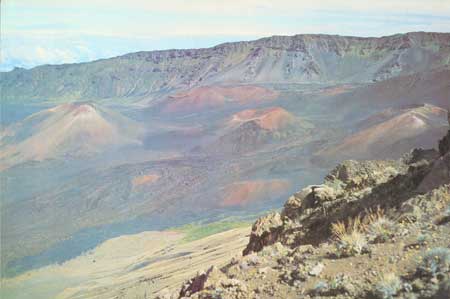
PLATE 29. Western part of Haleakala Crater, from Kalahaku
Overlook. Lava flows and cinder canes have partly refilled a stream-cut
valley. The cinder cones (left to right) are Puu o Maui, Puu o Pele,
Kamaolii, and Ka Lua o ka Oo. NPS photo.
Toward the end of the eruption of the Kula lavas volcanic activity decreased greatly in intensity or ceased altogether. Erosion was more than able to keep pace with the building of the mountain, and streams cut great canyons into the slopes of the mountain. Some of these were several thousand feet deep. Two of them, the Koolau and Kaupo canyons, cut far back into the heart of the mountain, and their heads coalesced to form one great central depression divided only by a low narrow ridge separating their drainage areas. This depression, modified by later erosion and volcanic activity, forms the present great "crater" of Haleakala (Plate 29), which thus is erosional, not volcanic, in origin.
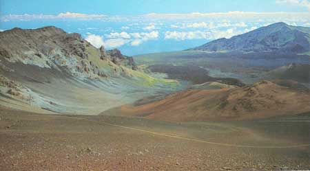
PLATE 30. Koolau Gap, formerly a deep stream-carved valley, is
now mostly filled with lava. NPS photo
At a still later time volcanism again increased in intensity, and a series of lavas and cinder cones (Plates 30, 31) known as the Hana volcanic series was erupted. Like the Kula rocks before them, the Hana lavas were erupted principally from a line of fissures that crossed the mountain from southwest to northeast. This line of fissures, forming the southwest and northeast rift zones of the volcano, crosses the crater. From the observation station at the crater rim a line of cinder cones and lava vents can be seen extending diagonally across the crater and up the far side. The original floors of the eroded valleys have been deeply buried by the lavas and cinder cones that form the present floor of the crater and of the Koolau and Kaupo gaps (Plate 29). The ridge that formerly separated the heads of the two valleys has largely been buried by the flood of later lavas, but part of it can still be seen projecting southward into the "crater" south-southwest of Hanakauhi Peak. The old lavas in the ridge are cut by many nearly vertical dikes, which are the congealed lava fillings of fissures many of which once fed surface lava flows.
Haleakala is the only volcano in the Hawaiian group, except on the island of Hawaii, that has erupted during the last few hundred years. About 1790, lava issued from two vents on the southwest rift, one at an altitude of 575 feet and the other at 1,200 feet, and formed a flow that went into the sea. This fresh flow is crossed by the road that follows the coast line from Makena to Keoneoio, at the head of La Perouse Bay.
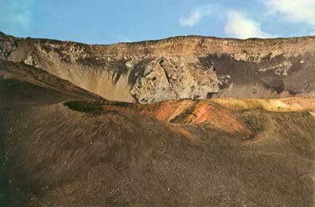
PLATE 31. Ka Luu o ka Oo cinder cone, from Kamaolii. In the
background dikes cut lava flows in the west wall of Haleakala
Crater. Hawaii Institute of Geophysics photo by G. A. Macdonald.