|
HAWAI'I VOLCANOES & HALEAKALA Volcanoes of the National Parks of Hawaii |

|
KILAUEA, HOME OF PELE, THE FIRE GODDESS
(continued)
Eruptions of 1972-74. In early February, 1972, lava quietly reappeared in the crater of Mauna Ulu, and on February 7 it started to pour down the east side of the cone into the shallow depression at the site of the former Alae Crater. Activity continued at fluctuating levels through 1972. The surface of the lava lake was generally between 60 and 100 feet below the crater rim. Vents on the east flank repeatedly produced small short-lived lava flows, and in late February one flow extended eastward as far as Napau Crater (Figure 8). In mid-March a new fissure opened east of Mauna Ulu and two vents formed on it, one at the north edge of the former Alae Crater and the other 650 feet farther northeast. From the latter a lava flow went eastward and spilled into Makaopuhi Crater. Lava from the other vent formed a lake in the Alae depression. Spattering around its edges built levees which held the lake at ever higher levels, and repeated overflows gradually built a broad, gently sloping shield volcano with the lake at its summit. Some overflows reached as much as 2 miles southeastward.
On August 9 a small eruption on the "mezzanine" floor in the eastern part of Makaopuhi Crater formed a flow which spilled into the deeper pit at the west end of the crater. Lava continued to drain sporadically into Makaopuhi from the Mauna Ulu vent complex, and by February 1973 the western pit was completely filled.
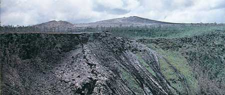
PLATE 24. Frozen lava cascades and vent fissure of the
November 1973 eruption on the wall of Pauahi Crater, June 1974. In the
center background is Mauna Ulu, with Puu Huluhulu on the left.
Hawaii Institute of Geophysics photo by G. A. Macdonald
Starting in the week of August 13, 1972, lava draining from Alae lava lake southeastward through lava tubes again flowed over Poliokeawe and Holei Palis, destroyed much of the Naulu forest, and spread over the coastal flat. On August 23 it reached the ocean. Lava continued to flow over the palis most of the time, with occasional short periods of flow into the sea, until about October 20. At that time activity in the Alae lake abruptly decreased, and drainage through the southeastern lava tubes ceased. Brisk activity resumed at Alae on October 24. November and December was a period of many short flows from vents on the flanks of the Alae shield, building it in both height and area. Flows entered the summit depression of the shield, gradually filling it, but the lava lake was not reestablished. The tube system in the flows gradually became better integrated and extended, and on January 5, 1973, a lava flow went over Poliokeawe Pali. By January 12 it had passed Holei Pali and was starting to spread slowly across the flat, and on February 24 it reached the ocean half a mile west of Apua Point. Through March and April lava continued to flow from the Mauna Ulu-Alae vent into the sea, again forming pillow lava, building the shoreline seaward 800 feet, and adding 0.1 square mile to the island. About May 1 the feeding tubes became clogged and lava stopped flowing to the sea, but for 5 days spectacular cascades tumbled down the palis.
On April 26 the island of Hawaii was shaken by a major earthquake that originated beneath the eastern slope of Mauna Kea, and this may have caused some disruption to Kilauea's internal plumbing system. At any rate, on May 5 the lava abruptly drained away from the vents at Mauna Ulu and Alae, leaving the Mauna Ulu crater more than 600 feet deep, with dangerously caving walls. Following a series of small earthquakes, at 10:25 a.m. a fissure opened in the western end of Pauahi Crater (Figure 8) and small lava fountains quickly flooded the western crater floor to a depth of 125 feet. At 11:20 the fountains started to die down rapidly, and lava started draining back into the fissure. By 12:30 the fountains were dead and the lava level had dropped 60 feet. About 12:55 a new series of fissures opened across the south edge of Hiiaka Crater, and at 1:07 p.m. still another fissure opened just west of the Chain of Craters Road. Lava crossed the road and cascaded into the crater. Activity started to die out about 3 p.m., and by 5 it was virtually over, but about 4:45 still another brief outbreak took place half a mile farther west, just west of the Hilina Pali Road.
On May 8 lava returned to Mauna Ulu crater. The level of the lake rose slowly, and by May 30, when lava also reappeared at the Alae vent, the lake surface was 130 feet below the crater rim. On July 20 the lake was only 40 feet below the rim, but activity became more and more sluggish, and by July 25 no live lava was visible. Not until September 4 did it reappear, only to disappear again on September 7. On September 26 red lava again became visible and activity gradually increased. By November 4 the crater was full and overflowing; but on November 10 a series of small earthquakes was accompanied by a strengthening of tremor, sinking of the Kilauea summit area, and rapid draining of the lava lake. Alert Volcano Observatory personnel recognized that the pattern probably indicated that a new outbreak was imminent, and prompt action by National Park personnel evacuated some 500 visitors from the observation area at Puu Huluhulu.
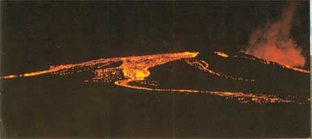
PLATE 25. Overflow of Mauna Ulu, seen from near the Chain of
Craters Road, June 1, 1974. NPS photo by Glen Kaye
Two hours later, at 9:47 p.m., the new outbreak came along fissures in the north wall of the east pit of Pauahi Crater. The fissures quickly extended both eastward and westward, and at 10:28 a row of lava fountains blocked the Chain of Craters Road. Shortly afterward more fountains blocked the emergency escape road. Fountaining outside Pauahi Crater stopped by 6 o'clock the next morning, and the activity within the crater decreased greatly, but spattering and a small lava lake continued in the western pit until December 9.
Mauna Ulu remained quiet until December 12, when again lava quietly reappeared. Activity remained weak until January 24, 1974, when there began a series of periods of more intense activity, each lasting from 11 to 35 hours, during which lava rose to the lip of the crater and sent flows down the flanks of the cone, while lava fountains up to 250 feet high built a spatter cone at its summit. In early April, and again in early May, flows reached the southern palis, but stopped short of the ocean. The period was characterized by geyser-like action, referred to by Volcano Observatory scientists as "gas-piston cycles," in which the level of lava in the vent gradually rose several meters, often overflowing, and remained at high levels for 5 to 30 minutes, culminating in intense spattering and roaring release of gas, after which the lava surface would drop abruptly to its former level. From May 29 to June 2 a spectacular overflow sent lava down all sides of Mauna Ulu, and a flow reached the flat at the foot of Holei Pali, but stopped nearly 2 miles short of the ocean. Following the overflow, the lake level dropped 60 to 150 feet below the crater rim, but remained sluggishly active until July 22. On that date, at the end of the eruption in the caldera, it drained away, and at the end of the year it had not reappeared. The Mauna Ulu shield had grown to a height of approximately 400 feet above the pre-1969 ground surface.
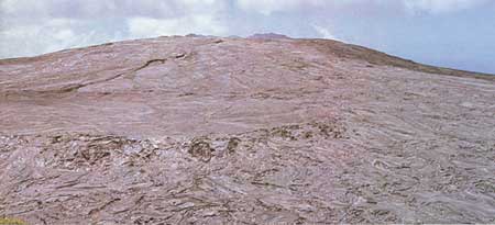
PLATE 26. Mauna Ulu, from Puu Huluhulu, June 19, 1974. A small
spatter cone is visible at the summit of the shield. Compare Plate
20. Hawaii Institute of Geophysics photo by G. A. Macdonald
At 4 a.m. on July 19 there began a rapid deflation of the summit region of Kilauea, accompanied by a swarm of sharp earthquakes, and at 10:30 strong tremor indicated the movement of subterranean lava. About 12:30 fissures opened across the edge of the caldera a short distance south of the fissures of the August 1971 eruption, and extended northeastward across Keanakakoi Crater. Fountains on the ledge between the caldera and Keanakakoi sent spectacular cascades down the caldera wall, to join other lava from fountains on the caldera floor. This formed a flow that moved northward to a point nearly below the Volcano House, covering most of the August 1971 lava. Meanwhile Keanakakoi Crater was partly filled by new lava. A separate flow advanced eastward, pouring into Lua Manu and crossing the Chain of Craters Road. Most of the activity had ended by the morning of July 20, but spattering and weak lava flow continued at one vent until July 22.
After the July eruption the summit of Kilauea soon started swelling again. The center of inflation migrated southwestward from near Keanakakoi to a point nearly south of Halemaumau. About 1:25 a.m. on September 19, an eruption started in Halemaumau, and activity spread southwestward to the wall of the caldera. The location of the fissure was very close to that of the September 1971 eruption. Lava spread southward across the Crater Rim Road, and quickly flooded the floor of Halemaumau. The eruption ended at about 9:30 a.m. By that time about 14,000,000 cubic yards of lava had been erupted, but about 6,000,000 of this drained back into vents in Halemaumau.
The September eruption had barely ended when inflation of the Kilauea summit resumed. It continued, slowly and irregularly, through the rest of the year until, at about 3 a.m. on December 31, lava again broke out. This time the eruption was in the Ka'u Desert at the south edge of the caldera near the center of swelling. Briefly, lava fountains played to heights of 100 to 200 feet, and lava flows poured down the south slope of Kilauea outside the caldera. But the show was over by about 8 a.m.
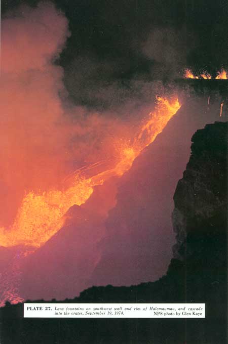
PLATE 27. Lava fountains on southwest wall and rim of
Halemaumau, and cascade into the crater, September 19, 1974. NPS
photo by Glen Kaye
Steam vents of Kilauea. Steam issues from the ground at many places in and around Kilauea caldera, and along Chain of Craters Road. For the most part the steam is accompanied by no other gases, and is the result of heating of ground water by underlying hot bodies of rock. The depth of these hot bodies is unknown, but is probably a few hundred to a few thousand feet. At two localities — Sulphur Bank, just west of Park Headquarters, and the low cliff about a mile east of Halemaumau — the steam is accompanied by small amounts of other gases, notably hydrogen sulfide (with an odor like that of rotten eggs), which are derived from a magmatic source. The partial oxidation of the sulfide close to the ground surface results in the deposition of native sulfur. Sulfur also is being deposited at some of the vents of the August 1971 eruption on the caldera floor.
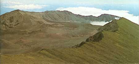
PLATE 28. An aerial view of the summit of Haleakala Volcano,
looking northeast. USGS Photo by G. A. Macdonald