
|
Geological Survey Professional Paper 215
Geology of the Southern Guadalupe Mountains, Texas |
INTRODUCTION
THE PERMIAN PROBLEM
The Permian system of the southwestern United States has been until recently one of the intriguing but little known subjects of American stratigraphy. In the latter half of the nineteenth century after the western United States was settled, the "red bed" sections of the Permian were studied and reported on by many geologists, but up to 1920 the existence of a contemporaneous marine sequence in western Texas and southeastern New Mexico was little appreciated. Since that year the discovery of extensive oil fields and potash beds in this region gave an impetus to the study of the Permian rocks, and furnished the geologist with records of hundreds of drill holes from which to deduce the nature of the strata not exposed at the surface. At the same time geologists have studied the rocks in the outcropping areas, and have compared them with the strata encountered by drilling.
Much remains to be done in order to understand the history of Permian time in the region. The physical and chemical conditions that caused the deposition of the various and often complexly related deposits need to be better understood. More of the fossils of the rich and interesting marine faunas should he described, and the relations of the fossils to their environments should be determined. Further, a satisfactory scheme of correlation is needed, and also a subdivision into series that will express the contemporaneity of strata in different areas. One useful contribution to the solution of these problems is the detailed study of sequences of rocks exposed at the surface in the different mountain ranges of Texas and New Mexico.
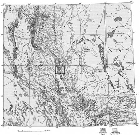
This report deals with one such sequence of rocks in western Texas, the one exposed in the southern Guadalupe Mountains (for location, see fig. 1). Here, the Permian rocks are magnificently exposed, to a thickness of about 4,000 feet (for a typical exposure, see pl. 1). They are all of marine origin, and belong to the middle part of the system, with the base concealed and the top absent. Overlying and underlying beds, however, are found in nearby areas.
|
| FIGURE 1.—Map of western Texas, southeastern New Mexico, and adjoining area in Mexico, showing topography, political divisions, oil and gas fields, and other features, compiled from various sources, including U. S. Geological Survey's topographic maps of Texas and New Mexico (1:500,000), oil and gas map of Texas (1:750,000), and American Geographical Society's Chihuahua sheet, millionth map of Hispanic America (1:1,000,000). (click on image for a PDF version) |
PRESENT INVESTIGATION
Field work on which this report is based was carried out mainly during eight months in 1934 and 1935, during which time I was assisted by H. C. Fountain. Expenses for this work were paid by a grant from the Penrose bequest of the Geological Society of America. Some additional field work was done in subsequent years, especially in the spring of 1939. In 1945 and 1946, I studied a series of vertical aerial photographs made by the U. S. Army, covering the southern Guadalupe Mountains and surrounding areas. This study made possible a final revision of the geologic mapping. As a result of the investigations between 1934 and 1946, an area 25 miles long and 18 miles wide, covering 42 square miles, has been surveyed geologically (pl. 3).
Most of the fossils mentioned in this report were collected by H. C. Fountain in 1934 and 1935, to obtain which he spent many hours of patient labor with the hammer. The excellence of the specimens that he obtained is a testimony of his devotion to the work.
The greater part of the fossils collected were studied by the late G. H. Girty of the Geological Survey, who also visited our party in the field for three weeks. The fusulinids have been studied by C. O. Dunbar of Yale University and J. W. Skinner of the Humble Oil Co., and the cephalopods by A. K. Miller and W. M. Furnish of the State University of Iowa. The results of the work of Dunbar and Skinner,1 and of Miller and Furnish,2 have been published; but the information that was Supplied by Girty is published for the first time in this report.
1Dunbar, C. O., and Skinner, J. W., Permian Fusulinidae of Texas, in The Geology of Texas, vol. 3, Texas Univ. Bull. 3701, pp. 519-525, 1937.
2Miller, A. K. and Furnish, W. M., Permian ammonoids of the Guadalupe Mountain region and adjacent areas: Geol. Soc. America Special Paper 26, 1940.
Some thin sections of sandstones from the region were studied by Ward Smith, thin sections of volcanic ash were studied by G. S. Ross, and insoluble residues of limestones by Charles Milton, all of the Geological Survey. Chemical analyses of limestones, of volcanic ash, and of other rocks were made by K. J. Murata and E. T. Erickson in the chemical laboratory of the Geological Survey.
The data in the chapters on tectonics and geomorphology of the southern Guadalupe Mountains are incidental results of the stratigraphic investigation; I believe they comprise information of so much interest, and are so useful a contribution to the knowledge of the Basin Ranges, that I give them in detail. In preparing these chapters, I have been aided by consultation with W. H. Bradley, James Gilluly, and W. W. Rubey of the Geological Survey.
Many of the pictures in the report are based on pencil drawings which I executed as accurately as possible in the field. I believe that these drawings bring out many geological features more accurately than photographs. Some of the views, especially plates 4 and 5, form a series of panoramas around the escarpments of the southern Guadalupe Mountains.
This report was largely written between 1936 and. 1938, but was extensively revised in 1940. Publication of the report by the Geological Survey was postponed during the period, of World War II. A preliminary description of the stratigraphic results was included in a general summary of the Permian of west Texas and southeastern New Mexico, published in 1942, and a preliminary edition of the geologic map was published in 1944.3 Because of the fact that a general summary of the Permian was published in 1942, only incidental mention is made of regional matters in this report, and main emphasis is given to descriptions of the local geology.
3King, P. B., The Permian of west Texas and southeastern New Mexico: Am. Assoc. Petroleum Geologists Bull., vol. 26, pp. 535-763, 1942. King, P. B., and Fountain, H. C., Geologic map of southern Guadalupe Mountains, Hudspeth and Culberson counties, Texas: U. S. Geological survey Oil and Gas Investigations, Preliminary map 18, 1944.
Since 1940, only minor revisions have been made in the present report, and it may be that some geological publications or discoveries made since that date, which are pertinent to the subject, have been overlooked.
ACKNOWLEDGMENTS
As may be seen from the preceding statement, I have had the aid of many collaborators and advisers through the years in which this report was in preparation. In addition to those mentioned, I have received aid from many others not named, especially on the staff of the Geological Survey and among the petroleum geologists stationed in west Texas and southeastern New Mexico. To all these persons, I wish to extend thanks and appreciation.
During the field work, A. J. Williams, Wallace Pratt, the Grisham-Hunter Corporation, and other landowners allowed access to their properties, and were helpful in many other ways. With J. T. Smith and Walter Glover, both residents of the region for many years, I have had many interesting conversations, during which I learned much regarding the local history and geography.
Thanks are also extended to the Edgar Tobin Aerial Surveys and to the U. S. Army Air Corps for supplying small collections of oblique aerial photographs of the southern Guadalupe Mountains, and for permitting the publication of two of them, which appear as plates 1 and 18 of this report. In the preparation of the topographic base for the eastern part of the area shown on the geologic map (pl. 3) use was made of surveys by the Humble Oil Co., the El Paso Natural Gas Co., and the Pasotex Pipe Line Co. The information supplied by these organizations is gratefully acknowledged.
My list of acknowledgments would not be complete if I failed to mention my wife, Helen Carter King, whose inspiration, both as a field companion and as a critic of this manuscript, has done much to bring it to completion.
| <<< Previous | <<< Contents >>> | Next >>> |
pp/215/intro.htm
Last Updated: 28-Dec-2007