
|
Texas Bureau of Economic Geology
The Big Bend of the Rio Grande: A Guide to the Rocks, Geologic History, and Settlers of the Area of Big Bend National Park |
CONTENTS
Front Cover (1971 edition): Santa Elena Canyon of the Rio Grande
Front Cover (1987 edition): View of Casa Grande from the lower part of the South Rim trail within the Basin, Big Bend National Park (photo by Raquelle Smalley Keegan)
The scene is set
Acknowledgments
Geologic time scale
Paleozoic era
Mesozoic era
Cenozoic era
Geology, place names, and legends
Marathon BasinVegetation
The Solitario
Persimmon Gap
Dog Canyon
Tornillo Flat
Hot Springs
Boquillas
Boquillas Canyon
Presidio de San Vicente
San Vicente Mountain
Mariscal Mountain
Cow Heaven anticline
Glenn Spring
The Chisos Mountains
Alsate's Face
The Watchman's House
The Basin
The South Rim Trail
Boulder Meadows
The Lost Mine Trail
The Window Trail
Burro Mesa
Castolon village
Santa Elena Canyon
Origin of the Rio Grande canyons
Candelilla
Guayule
Sotol
Maguey or century plant
Lechuguilla
Spanish dagger, Spanish bayonet, or soapweed
Beargrass or basketgrass
Mesquite
Ocotillo
Carrizo cane
The cactus family
Tasajillo
Cholla
Peyote
Grasses
Honey
Native healers
Sunstroke
Arthritis
Yellow jaundice
Heart disease
High blood pressure
Pneumonia and colds
Poison
Rattlesnake bite
Tonics
Nearby frontier towns
Terlingua
Study Butte
Lajitas
Index (omitted from the online edition)

|
| Frontispiece: "Nugget." This old horse never trained for the Kentucky Derby but he did carry the writer about 73 miles between sunrise and sunset in the southern Big Bend country. |
ILLUSTRATIONS
Frontispiece "Nugget," a cow horse of the Big Bend country
1. Map of West Texas showing some of the early trails and Big Bend National Park
2. The Texas Highway Department's first camp in the area that is now Big Bend National Park
3. A traveler's lonely camp in the Big Bend country
4. Big Bend National Park with principal geologic and topographic features and roads
5. Geologic time scale
6. Outline map of North America showing general location of the most persistent Paleozoic sea troughs
10. Primitive armored fish
11. Primitive amphibian
12. Outline map of North America showing area submerged by the Mesozoic sea
15. Swimming reptiles
16. Flying reptiles
17. Skull of Phobosuchus riograndensis collected in Big Bend National Park
18. Agatized tree stump with roots embedded in rock; west side of Tornillo Creek, southern Tornillo Flat
19. Blocks of the earth's crust that have been broken and tilted by faults
20. Some Cenozoic mammals
21. Exhibit shelter containing some of the Mesozoic mammal bones found in the Park
22. Anticlines and synclines produced by folding of layered rocks
23. Rocks that are tilted in one direction
24. Sketch showing intrusions and extrusions in cross-section and plan views
25. Steeply tilted Paleozoic rocks about 15 miles east of Marathon, Texas
26. Diagram showing the development of folds, overturned folds, and thrust faults in horizontal rocks
27. Structure section of Marathon Basin
28. Conodonts
29. The development of laccolithic domes
30. Aerial photograph of the Solitario
31. A, Thrust faulting and overturned fold in Cretaceous rocks. B, Panoramic sketch, Persimmon Gap area
32. Asymmetric fold in Dog Canyon
33. Vertical beds of Lower Cretaceous limestone in the south wall of Dog Canyon
34. A, Sketch showing development of simple stream erosion. B, Photograph of arroyo development in horizontal rocks
35. A, Sketch showing development of step-like topography on horizontal rocks. B, Badlands development
36. The Hot Springs trading post as it appeared in 1936
37. The Boquillas Formation
38. Mail day—a group of Mexican Nationals who came to get their mail
39. Boquillas Mexico, in 1936
40. The aerial tramway which crossed the Rio Grande
41. The Sada "family" in front of their restaurant-home at Boquillas, Texas
42. The head of Boquillas Canyon as seen from the look-out stop along the Park road to the canyon
43. The Sierra del Carmen in Mexico
44. A metate, or rock mill, in the limestone ledge exposed in the river bank at the west end of the Rio Grande Village
45. A tinaja, a natural depression in the rocks
46. One of the last inhabited places at San Vicente, Texas
47. Aerial view looking southeast across the north end of Mariscal Mountain, Sierra San Vicente, and toward the Sierra del Carmen—Fronteriza escarpment south of Boquillas, Mexico
48. The head of Mariscal Canyon
49. Sketch of a graben that illustrates the structure between Mariscal and San Vicente Mountains
50. Ruins of the old Mariscal mine and part of Mariscal village as they appeared in 1963
51. Aerial photograph showing folded rock at the north end of the Cow Heaven anticline
52. Sketch showing how erosion develops valleys along the crest of an anticline
53. Elephant Tusk
54. Dominguez Mountain
55. Punta de la Sierra
56. A dike exposed in the channel of the Rio Grande
57. The Johnson ranch home and trading post in 1936
58. Aerial photograph of the Johnson ranch area in 1936 with Rio Grande, fields, and landing strip
59. Furs at the Johnson ranch trading post in 1936
60. Mortar in a boulder
61. Rock ledges elevated by the Glenn Springs intrusion
62. Dike filling of a fissure which originated from the Glenn Springs intrusion
63. Glenn Spring in 1936
64. Some abandoned adobe jacales as they appeared in 1936
65. The Glenn Springs battlefield site in 1936
66. The Glenn Springs store in 1936
67. Green Gulch, the only entrance by road to the Chisos Mountains Basin
68. A massive lava flow, about 50 feet thick, that forms the South Rim of the Chisos Mountains
69. Vernon Bailey Peak
70. Casa Grande
71. Alsate's Face
72. The Watchman's House
73. The Basin
74. The Window
75. Panoramic view of the Basin in the Chisos Mountains
76. Looking across the Basin toward Emory Peak
77. Rock jointing in the top of Emory Peak
78. The Cowboy Boot
79. The piñon-juniper forest on the higher slopes of the Chisos Mountains
80. Piñon forest in the highest Chisos Mountains
81. Looking south at the north side of Pulliam Peak
82. A small group of wild burros which are commonly seen in the lowland desert areas
83. Looking west at the Burro Mesa fault-line scarp
84. A plug-like intrusion on Burro Mesa that tilted the lava beds to form ring hogbacks around the intrusion
85. Sketches showing the development of Burro Mesa
86. Crumpled beds in the Chisos Formation that crop out between the Ward Mountain intrusion and the Burro Mesa fault
87. Canyon cut in the Chisos Formation
88. Looking northeast at Mule Ear Peaks
89. Cerro Castellan
90. A small volcanic neck near Cerro Castellan
91. Aerial view of Santa Elena Canyon
92. Sketch of Santa Elena Canyon
93. Smugglers Cave in the wall of Santa Elena Canyon
94. Sketches showing the development of drainage across a fault-block mountain
95. Willow Mountain
96. Barren surface characteristic of much of the Big Bend area
97. An abandoned ranch home near Dodson Spring
98. Mule Ear Spring
99. The candelilla wax plant in its native habitat
100. Candelilla wax being taken by pack train to the rendering vat
101. A stack of candelilla wax plant awaiting rendering
102. A small candelilla wax-rendering operation at Glenn Springs
103. An old steam boiler used as a source of heat to render candelilla wax
104. Sotol
105. Maguey or century plant
106. Spanish dagger, Spanish bayonet, soapweed, or yucca
107. Beargrass or basketgrass
108. Ocotillo
109. Ruins of the old Straw House as it appeared in 1936
110. Pitaya or strawberry cactus
111. A bee cave in Estufa Canyon about 5 miles east of the Chisos Mountains
112. Terlingua, as it appeared in 1936
113. The Chisosmine and dump in 1936
114. Freight wagon en route to Terlingua in 1936
115. The Terlingua cemetery in 1936
116. Lajitas, Texas, in 1936
117. National Park Service headquarters and administration building (omitted from the online edition)
PLATES
II. Geologic map, Big Bend National Park, Brewster County, Texas
TABLE
|
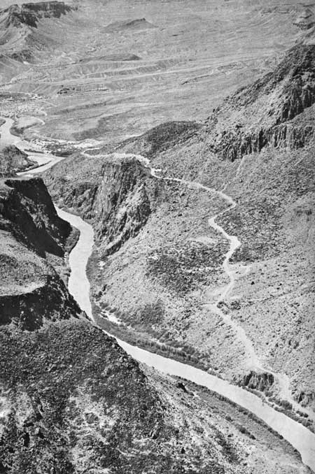
| Back Cover (1971 edition): Canyon of the Rio Grande at the "Big Hill." Santana Mesa to upper right. Road connects Big Bend National Park and Presidio, Texas. |
| <<< Previous | <<< Contents >>> | Next >>> |
state/tx/1968-7/contents.htm
Last Updated: 22-Jun-2009