
|
Geological Survey Professional Paper 754-A
Glacial and Postglacial Geologic History of Isle Royale National Park, Michigan |
MODIFICATION OF TOPOGRAPHY BY GLACIAL EROSION
Glacial quarrying was probably the most important process of glacial erosion on Isle Royale (Zumberge, 1955); it was controlled chiefly by bedrock structures. The alternation of massive, poorly jointed rock and highly jointed rock furthered the development of the preglacial topography by stream erosion and was also the major control for glacial quarrying. The main role of glacial erosion was to accentuate the asymmetry of the existing ridge-and-valley topography and to interrupt the preglacial subsequent streams with alined bedrock lake basins.
It is unlikely that short tributary creeks of low gradient could be responsible for the development of the deep, narrow ravines along some of the regional joints on the northwest end of the island. These ravines probably were excavated by glacial quarrying along a weakened zone of fractured rock, but it is difficult to imagine how they could have been excavated to this degree by ice moving roughly perpendicular to the ravines, that is, in the direction indicated for the Valders advance. There is abundant evidence in the northwestern Lake Superior region to indicate that during one or more pre-Valders advances, ice moved in a southerly direction nearly parallel to the ravines (compare Sharp, 1953; Zoltai, 1965). It is therefore suggested that the bedrock of these ravines was excavated by pre-Valders ice.
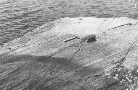
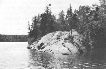
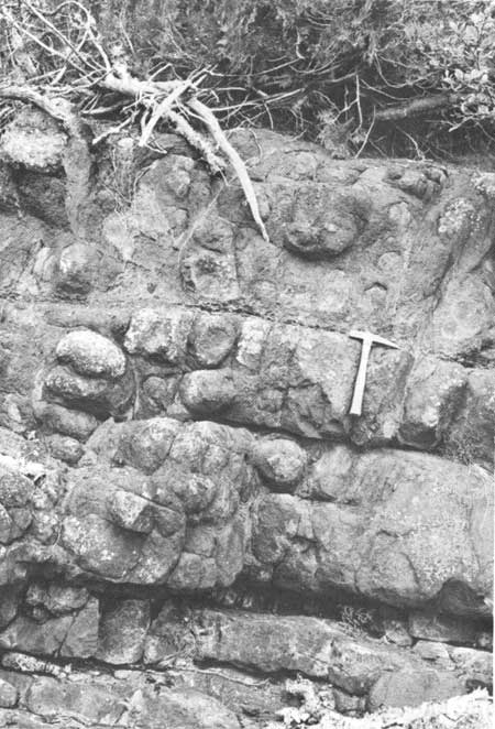
Whereas glacial quarrying was the major modifying factor in the development of the gross topography of Isle Royale, glacial abrasion was responsible for rounding, polishing, and striating the many rock outcrops that characteristically indicate the former passage of glacial ice (figs. 5, 6). The quarrying and scouring was so effective, in fact, that deeply weathered rock is found only in a few places on the lee sides of outcrops where it was protected from the action of moving ice. In one such protected place on the northwesternmost promontory of the main island, a basalt lava flow is spheroidally weathered to a depth of about 6 feet (fig. 7). In cross section, the weathered zone, exposed by storm waves along the shore, grades downward into less weathered rock that is more resistant to wave action. Here, chemical weathering along a rectilinear fracture system has resulted in the formation of remnant "corestones" embedded in decomposed material: the tendency of the corestones to become spheres is the result of more effective penetration by the decomposing solutions at edges and corners of the rectilinear blocks than in the middle of their planar faces. Because weathering to such depth could hardly have taken place since the retreat of the last ice sheet 10,000-11,000 years ago, the outcrop is interpreted as representing an earlier weathering cycle, either interglacial or possibly preglacial altogether.
|
| FIGURE 5.—Glacial striations. Near Moskey Basin campground. |
|
| FIGURE 6.—Glacially rounded and striated outcrop. Pickerel Cove near portage trail.< |
|
| FIGURE 7.—Zone of spheroidal weathering in a basalt lava flow. This zone of partly decomposed rock escaped removal by glacial erosion because of its protected location. Northwest ernmost promontory of Isle Royale. |
There is no residual soil profile developed upon the present upper surface of the weathered rocks at the described locality, indicating that some weathered rock was removed during glaciation. Because depth of weathering depends upon many local variables, this spheroidally weathered zone may not be representative of large areas of the island. Nevertheless, it gives a qualitative measure of the possible depth of preglacial weathering under local conditions and an estimate of the amount of material that might have been removed in areas having similar weathering conditions but lacking adequate protection from glacial erosion during Valders and earlier glacial advances.
| <<< Previous | <<< Contents >>> | Next >>> |
pp/754a/sec4.htm
Last Updated: 01-Mar-2005