
|
Geological Survey Professional Paper 754-A
Glacial and Postglacial Geologic History of Isle Royale National Park, Michigan |
BEDROCK GEOLOGY AND ITS CONTROL OF PREGLACIAL TOPOGRAPHY
The bedrock formations of Isle Royale consist of a series of lava flows with minor interbedded standstone, conglomerate, and pyroclastic rock (Portage Lake Volcanics) overlain by a thick sequence of conglomerate and sandstone (Copper Harbor Conglomerate). This succession of Precambrian rocks has been tilted south eastward and forms part of the north limb of the Lake Superior syncline or structural trough. Dips of the strata range from less than 10° to more than 50°; they are generally steeper on the north side of the island than on the south and average less than 20° for the island.
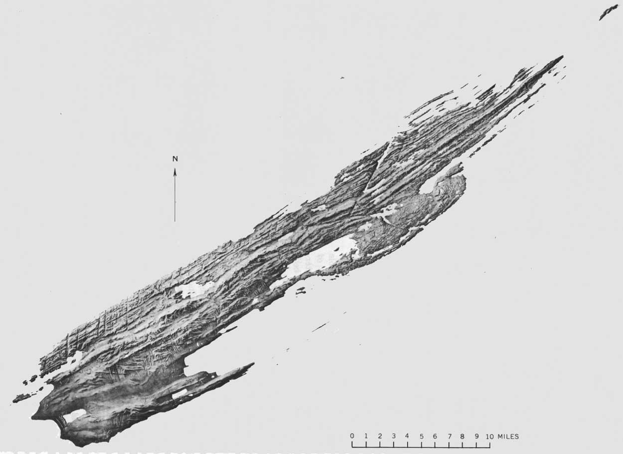
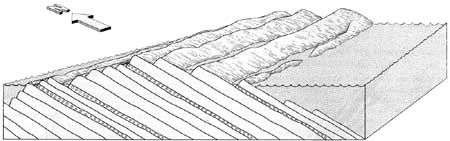
The present topography consists of a series of ridges and valleys alined in a northeast-southwest direction parallel to the regional strike of the bedrock formations (fig. 3). The southeast-facing slopes are controlled by the structural dip and are gentle compared with the northwest-facing antidip slopes; together the slopes provide a marked asymmetry to the ridge-and-valley cross section (fig. 4). Large variations in resistance to erosion are evident within the bedrock sequence. The sedimentary rocks and amygdaloidal zones at the base and top of flows are less resistant than the massive flow interiors and were selectively removed by stream erosion prior to glaciation. Moreover, the interflow sedimentary rocks and thinner flows have better developed and closer spaced jointing than the massive interiors of the thicker flows and are therefore more susceptible to erosion.
|
| FIGURE 3.—Shaded-relief map of Isle Royale National Park (prepared by Alexius J. Burgess). (click on image for an enlargement in a new window) |
|
| FIGURE 4.—Relation between ridge-and-valley topography and tilted lava flows and sedimentary rocks. Stippled areas indicate water; open circles, sedimentary deposits. |
Although the primary ridge-and-valley topography is controlled by the strike direction of the tilted bed rock formations, crosscutting ravines and drainages (fig. 3) are controlled chiefly by the regional joint system, a system of fractures developed in the rock formations in response to stresses imposed during the development of the Lake Superior syncline. One prominent joint set of this system trends northward at the west end of the island and changes progressively eastward to trend about 30° E. of N. at McCargoe Cove. Minor faulting has occurred along some of these regional joints, resulting in zones of closely jointed and fractured rock more susceptible to erosion than the surrounding rock with wider spaced jointing. These zones are now marked by a series of prominent crosscutting ravines, especially well displayed along the north coast of the island between its west tip and Lake Desor. McCargoe Cove is an outstanding example of a joint-controlled, linear topographic feature.
| <<< Previous | <<< Contents >>> | Next >>> |
pp/754a/sec3.htm
Last Updated: 01-Mar-2005