
|
Geological Survey Professional Paper 65
Geology and Water Resources of the Northern Portion of the Black Hills and Adjoining Regions in South Dakota and Wyoming |
WATER RESOURCES
SURFACE WATERS.
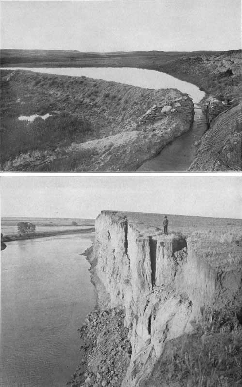
The average annual rainfall in the northern Black Hills region is about 20 inches, the amount being considerably smaller than this on the plains and greater in the higher mountains. A part of the precipitation is in the form of snow and the remainder falls mostly in heavy showers of short duration during the spring and early summer months. As much of the surface has thin soil and only moderate areas present porous rocks, the water of rain and melting snows runs off rapidly, usually in freshets that follow storms or the rapid melting of snow, the latter taking place during the warm spells of early spring. In the eastern portion of the area there usually is no continuous snow cover for any length of time. In consequence of these conditions the minor creeks contain but little running water during the greater portion of the year. Springs are rare and of small volume in the lower lands. A large amount of the local run-off in this region could be saved by dams and made available for stock and local irrigation. There are dam sites at many localities where a moderate water supply could be impounded (see Pl. XX, A), but as the evaporation in this region is about 6 feet a year a large extra amount of water would have to be collected to compensate for this loss.
|
| PLATE XX.—A (top), RESERVOIR NORTH OF BELLE FOURCHE, S. DAK., HELD BY SMALL DIRT DAM. B (bottom), CAVING BANK ON BELLE FOURCHE RIVER, EAST OF SNOMA, S. DAK. Wide alluvial flats in distance. |
BELLE FOURCHE RIVER.
Belle Fourche River has a drainage basin of about 3,250 square miles above Belle Fourche. The flow has been gaged at that city since 1903 and found to vary from a minimum of 1 second foot in June, 1903, to nearly 6,000 feet in June, 1904. Ordinarily it varies from 50 to 200 feet; the mean for 27 months in 1903-1906 is about 300 second-feet. In 1906 the river was gaged at the diversion dam of the United States Reclamation Service, 1-1/2 miles below Belle Fourche and below the mouth of Redwater Creek. After the usual flood in the latter part of May and June the flow varied from 72 to 775 second-feet in August and averaged from 221 to 266 feet in August, September, October, and November. The following table shows the monthly flow for three years:
Estimated monthly discharge of Belle Fourche River at Belle Fourche,
S. Dak.
[Drainage area, 3,250 square miles.]
| Date. | Discharge in second-feet. | ||
| Maximum. | Minimum. | Mean. | |
| 1903. | |||
| Junea | 225 | 1 | 57 |
| Julyb | 950 | 5 | 117 |
| August | 4,065 | 76 | 751 |
| September | 3,855 | 58 | 624 |
| October | 82 | 47 | 54 |
1904. | |||
| March 11-31c | 1,825 | 206 | 803 |
| April | 505 | 137 | 277 |
| May | 1,615 | 147 | 373 |
| June | 5,941 | 211 | 1,495 |
| July | 317 | 61 | 148 |
| August | 104 | 15 | 38.3 |
| September | 158 | 45 | 67.1 |
| October | 775 | 45 | 102 |
| November | 79 | 56 | 67.8 |
| Decemberd | 104 | 59 | 77.2 |
1905. | |||
| March 7-31e | 215 | 75 | 127 |
| April | 114 | 78 | 87.7 |
| May | 580 | 72 | 219 |
| June | 955 | 90 | 344 |
| July | 1,720 | 134 | 531 |
| August | 2,914 | 90 | 531 |
| September | 175 | 55 | 76.6 |
| October | 310 | 75 | 105 |
| November | 90 | 75 | 83.7 |
1906. | |||
| April | 1,640 | 170 | 473 |
| May | 1,940 | 175 | 606 |
| June 1-23 | 3,290 | 175 | 594 |
aJune 21 to 27, inclusive, estimated.
bJuly 19 and 20 estimated.
cIce, January 1 to March 10.
dIce, December 29-31; discharge applied as for open channel.
eIce, January 1 to March 6, inclusive.
| |||
REDWATER CREEK.
Redwater Creek rises on the east slope of the Bear Lodge Mountains, flows for many miles through the Red Valley, and receives several branches from the high limestone region to the south. The main stream heads north of Sheep Mountain and carries a small volume of water, which is augmented by a similar small flow from North Redwater Creek. Near Beulah the stream is joined by South Redwater and Sundance creeks, which ordinarily do not flow at their mouths, and by Sand Creek and Bear Gulch, two living streams that bring a large volume of water from the limestone region lying farther south. Sand Creek has a small flow in its upper course but sinks for some distance to emerge again in large springs about 4 miles south of Beulah. It then flows through a canyon for about 3 miles, and, joining the Redwater a short distance north of the village, triples or quadruples the volume of that stream. Crow Creek contributes a small flow and the volume is greatly increased by Spearfish Creek, which is the largest affluent. The latter receives considerable water from two large springs issuing from talus of the northwest slopes of Sundance Mountain.
The total area of the Redwater drainage basin is about 1,020 square miles. The stream has been regularly gaged for the past few years near its mouth in Belle Fourche. The flow is continuous and varies from 100 to 300 second-feet through most seasons; it averaged 285 feet for 27 months in 1903-1906. In some years its midsummer flow diminishes to less than 100 second-feet for a short period. In time of flood the flow exceeds 1,000 second-feet; in June, 1904, it reached 8,050 feet. There is an additional flow in the Redwater canal. The results of gagings of the creek and canal are given in the following tables:
Estimated monthly discharge of Redwater Creek at
Belle Fourche, S. Dak.
[Drainage area, 1,020 square miles.]
| Date. | Discharge in second-feet. | ||
| Maximum. | Minimum. | Mean. | |
| 1903. | |||
| July 21-31 | 136 | 72 | 91 |
| Augusta | 720 | 72 | 162 |
| Septemberb | 990 | 119 | 291 |
| October | 153 | 119 | 123 |
1904. | |||
| March 10-31c | 253 | 174 | 213 |
| April | 279 | 166 | 222 |
| May | 279 | 81 | 144 |
| June | 8,050 | 174 | 1,096 |
| July | 349 | 81 | 177 |
| August | 174 | 65 | 92.5 |
| September | 241 | 134 | 180 |
| October | 390 | 174 | 222 |
| November | 217 | 188 | 195 |
| Decemberd | 286 | 188 | 218 |
1905. | |||
| March | 210 | 134 | 171 |
| April | 210 | 178 | 192 |
| May | 1,144 | 178 | 554 |
| June | 410 | 163 | 256 |
| July | 1,097 | 303 | 520 |
| August | 374 | 120 | 247 |
| September | 194 | 120 | 170 |
| October | 410 | 184 | 296 |
| November | 457 | 410 | 445 |
1906 | |||
| March 26-31 | 1,070 | 283 | 611 |
| April | 240 | 206 | 219 |
| May | 727 | 216 | 333 |
| June | 355 | 230 | 281 |
aAugust 30 and 31 estimated.
bSeptember 1 to 5, inclusive, estimated.
cIce conditions January 1 to March 9.
dIce conditions December 20-31; discharge applied as for open channel.
| |||
Estimated monthly discharge of Redwater canala at Minnesela, S. Dak.
| Date. | Discharge in second-feet. | ||
| Maximum. | Minimum. | Mean. | |
| 1904. | |||
| May 8-31 | 81 | 35 | 52.0 |
| June | 67 | 0 | 21.4 |
| July | 89 | 28 | 60.3 |
| August | 97 | 59 | 83.3 |
| September | 81 | 0 | 24.3 |
| October 1-11 | 32 | 4 | 22.9 |
1905. | |||
| June | 87 | 0 | 37.0 |
| July | 67 | 6 | 22.6 |
| August | 89 | 55 | 63.0 |
| September | 55 | 31 | 47.7 |
| October 1-23 | 36 | 0 | 18.0 |
1906. | |||
| May 27-31 | 49 | 15 | 28.2 |
| June | 35 | 0 | 10.5 |
| July | 122 | 6 | 70.5 |
| August | 113 | 10 | 56.3 |
| September | 52 | 4 | 22.1 |
| October 1-31 | 29 | 0 | 13.2 |
aWater turned into canal in May and out in October.
| |||
The water at this station joins that from the Belle Fourche station and together they constitute the available supply for the Belle Fourche reclamation project.

|
| PLATE XXI.—FALLS AT MOUTH OF LITTLE SPEARFISH CREEK. Water pouring over ledge of Pahasapa limestone on east bank of Spearfish Creek. |
SPEARFISH CREEK.
Spearfish Creek drains part of the high limestone plateau and adjacent slopes in the northern Black Hills and has a catchment area of about 230 square miles above the gaging station at Spearfish. Its principal affluent is Little Spearfish Creek, which ordinarily in summer has a flow of about 10 second-feet. (See Pl. XXI.) It carries a remarkably regular flow into Redwater Creek, which it joins at a point about 6 miles south-southwest of Belle Fourche. The ordinary flow of Spearfish Creek varies from 50 to 100 second-feet; the average for 35 months in 1903-1906 was 100 second-feet. The flow rarely diminishes to less than 50 second-feet and seldom exceeds 150 second-feet. In June, 1904, a flood of 4,150 second-feet was reported, and in July, 1905, one of 517 second-feet.
Estimated monthly discharge of Spearfish Creek near Spearfish, S.
Dak.
[Drainage area, 230 square miles.]
| Date. | Discharge in second-feet. | ||
| Maximum. | Minimum. | Mean. | |
| 1903. | |||
| June | 74 | 34 | 49 |
| July | 52 | 31 | 42 |
| August | 59 | 38 | 42 |
| September | 108 | 42 | 73 |
| October | 74 | 59 | 70 |
| November | 74 | 31 | 63 |
| December 1-20 | 66 | 28 | 59 |
1904. | |||
| April | 149 | 70 | 112 |
| May | 162 | 113 | 138 |
| June | 4,150 | 149 | 550 |
| July | 164 | 95 | 111 |
| August | 95 | 75 | 76.3 |
| September | 95 | 75 | 83.0 |
| October | 95 | 75 | 83.1 |
| November | 85 | 75 | 75.7 |
| Decembera | 85 | 44 | 69.2 |
1905.b | |||
| February 23-28 | 52 | 52 | 52.0 |
| March | 70 | 52 | 53.7 |
| April | 110 | 61 | 79.1 |
| May | 496 | 110 | 231 |
| June | 176 | 132 | 153 |
| July | 517 | 132 | 185 |
| August | 132 | 100 | 113 |
| September | 100 | 90 | 91.3 |
| October | 90 | 90 | 90.0 |
| November | 90 | 80 | 88.0 |
1906. | |||
| March 11-31 | 100 | 70 | 81.9 |
| April | 100 | 80 | 83 |
| May | 237 | 110 | 136 |
| June | 142 | 100 | 119 |
| July | 100 | 80 | 92.3 |
| August | 153 | 80 | 85.6 |
| September | 110 | 80 | 84.0 |
| October | 121 | 80 | 84.5 |
| November | 80 | 80 | 80.0 |
aDischarge from December 28-31 assumed as 50 second-feet.
bNo estimate for ice period.
| |||
RAPID CREEK.
Rapid Creek heads in the central portion of the Black Hills uplift and some of its upper branches gather their water from the limestone plateau. It always carries a moderate flow of water, but the amount varies greatly and much is lost in passing over the sandstone outcrops in the canyon above Rapid. A gaging station was established in June, 1903, on the wagon bridge one-fourth mile north of the Chicago and Northwestern Railway, where the following gagings have been reported:
Estimated monthly discharge of Rapid Creek at
Rapid, S. Dak.
[Drainage area, 410 square miles.]
| Date. | Discharge in second-feet. | ||
| Maximum. | Minimum. | Mean. | |
| 1903. | |||
| June | 240 | 124 | 163 |
| July | 197 | 64 | 117 |
| August | 102 | 48 | 75 |
| September | 102 | 48 | 73 |
| October | 72 | 48 | 63 |
| Novembera | 81 | 40 | 52 |
| December 1-19b | 72 | 33 | 41 |
1904. | |||
| March 20-31 | 101 | 47 | 70.1 |
| April | 141 | 87 | 120 |
| May | 153 | 120 | 142 |
| June | 798 | 146 | 434 |
| July | 284 | 96 | 175 |
| August | 96 | 64 | 81.3 |
| September | 196 | 68 | 88.0 |
| October | 99 | 74 | 86.8 |
| November | 92 | 76 | 85.5 |
| Decemberc | 96 | 62 | 79.2 |
1905. | |||
| January 1-6 | 85 | 70 | 79.0 |
| February 21-28 | 70 | 51 | 63.6 |
| Marchd | 93 | 60 | 72.5 |
| April | 104 | 60 | 83.2 |
| May | 241 | 58 | 173 |
| June | 259 | 99 | 131 |
| July | 880 | 203 | 359 |
| August | 299 | 110 | 195 |
| September | 128 | 80 | 102 |
| October | 98 | 67 | 84.2 |
| November 1-27 | 104 | 64 | 82.3 |
1906. | |||
| April | 91 | 43 | 67.7 |
| May | 312 | 83 | 126 |
| June | 223 | 91 | 148 |
| July | 99 | 45 | 74.3 |
| August | 480 | 71 | 166 |
| September | 91 | 84 | 87.1 |
| October | 99 | 71 | 81.7 |
| Novembere | 84 | 60 | 70.5 |
aNovember 16-20, inclusive, estimated.
bDecember 13-14, inclusive, estimated.
cCreek frozen December 2-5 and 25-20; discharge estimated.
dDischarge interpolated, March 3-15.
eDischarge estimated, November 18-26.
| |||
BOXELDER CREEK.
Boxelder Creek rises in the eastern slope of Custer Peak and is a stream of moderate size in the crystalline-rock area, but most of its water sinks in crossing the outcrops of permeable sandstones. The following gagings are reported:
Estimated monthly discharge of Boxelder Creek at Blackhawk, S.
Dak.
[Drainage area, 157 square miles.]
| Date. | Discharge in second-feet. | ||
| Maximum. | Minimum. | Mean. | |
| 1903. | |||
| July | 31 | 8 | 14.6 |
| August | 17 | 8 | 10.6 |
| September | 8 | 4 | 6.60 |
| October | 4 | .5 | 2.71 |
| November | .5 | .5 | .50 |
1904. | |||
| April 18-30 | 17 | 4 | 12.0 |
| May | 42 | 10 | 28.5 |
| June | 500 | 35 | 182 |
| July | 62 | 10 | 36.2 |
| August | 10 | 1.5 | 4.03 |
| September | 8 | 2.5 | 5.46 |
| October | 6 | 1.5 | 4.62 |
| November | 2.5 | 1.0 | 1.33 |
1905. | |||
| May 9-31 | 184 | 66 | 109 |
| June | 51 | 9 | 35.4 |
| July | 650 | 27 | 210 |
| August | 306 | 34 | 84.5 |
| September | 34 | 11 | 21.6 |
| October | 60 | 7 | 19.0 |
| November | 11 | 2 | 8.1 |
MINOR STREAMS.
Elk Creek.—Elk Creek heads in the northern portion of the crystalline-rock area north and east of Custer Peak, but it is a very small stream and most of its water sinks in crossing the outcrops of Minnelusa, Lakota, and Dakota sandstones. During dry seasons it does not flow in the region east of Piedmont Butte.
Bear Butte Creek.—Bear Butte Creek, a branch of the Belle Fourche, rises in the northern portion of the crystalline-rock area near Woodville and for 15 miles is a stream of moderate volume. Spring Creek, one of its branches from the north, flows the greater part of the year, but its flow is small. A few miles west of Sturgis, Bear Butte Creek sinks into the Minnelusa sandstone, but some water begins to flow again near Sturgis, and thence to its mouth there is usually a moderate volume of water throughout the year.
Whitewood Creek.—Whitewood Creek is a flowing stream of moderate volume which drains a long, narrow basin on the northeastern slope of the Black Hills. No gagings are available. The headwaters are in the hills south of Englewood and the creek flows through Deadwood. It receives considerable water from the gold mills at Lead, which are supplied in large part by an aqueduct from Spearfish Creek.
Little Missouri River.—Little Missouri River rises about 10 miles southwest of the Devils Tower and flows northward across the northwest corner of the area treated in this report. Ordinarily it carries but a small volume of water, but it is subject to freshets, in which the flow is often large. In dry weather the only branches from which it receives running water are Prairie Creek and North Fork of Little Missouri River, both very small streams. The flow in the river is maintained by small seeps and springs in its bottom.
Lytle Creek.—Lytle Creek rises on the northwestern slope of the Bear Lodge Mountains and flows northwestward, reaching the Belle Fourche a short distance east of the Devils Tower. Its small flow is derived mainly from springs which rise at intervals along its bed.
Blacktail Creek.—Blacktail Creek drains an inconsiderable area along the western slope of the Bear Lodge Mountains and flows in small volume to the Belle Fourche, which it joins half a mile southeast of Hulett.
Miller Creek.—Miller Creek, another small tributary, reaching the Belle Fourche in the northeastern portion of T. 52 N., rises on the east slope of the Bear Lodge Mountains. Numerous springs along the valley of this creek are important factors in sustaining the flow.
Thompson Creek.—Thompson Creek ordinarily carries a small amount of water, mostly in pools with feeble overflow from one to another.
Beaver Creek.—Beaver Creek is a small stream which empties into the Belle Fourche 10 miles below Hulett. It heads in a number of branches fed by small springs along the western slope of the Bear Lodge Mountains, and flows continuously from head to mouth, except possibly for short periods during the driest seasons. Its waters are used to some extent for irrigation, but the alluvial flats in its valley are narrow and not all well located for agriculture.
Hay Creek.—Hay Creek has several branches, which rise on the eastern slope of the Bear Lodge Mountains; it carries a small volume of water through Aladdin and eastward to Belle Fourche. The water is used to a small extent for irrigation at a number of points about Forks and farther east.
Stockade Beaver Creek.—Stockade Beaver Creek is fed by numerous springs near its head and receives other springs at intervals in its course. In ordinary seasons it carries about 10 second-feet of water.
Sand Creek system.—In its upper portion Sand Creek has a small flow, which has been extensively used for working placer deposits. The stream sinks near its junction with Cold Springs Creek and emerges again in extensive springs at its junction with Red Canyon. These springs occupy an area of about a half acre, and flow about 12 second-feet from the base of the Minnelusa. Many other springs are derived from this source in various parts of the Black Hills. The Red Canyon above Sand Creek contains but little water, mainly in local pools. Cold Springs Creek has extensive springs near the state line; it flows as far as the Crook-Weston county line and sometimes a little farther, but for the remainder of its course it is dry or presents only occasional pools, except in times of freshet. The various canyons east of Cold Springs Canyon ordinarily are dry or only occasionally contain water pools.
Beaver Creek.—Beaver Creek, in the Nigger Hill district, is a small flowing stream for part of its course, but seldom contains more than half a second-foot of water.
Oil and Skull creeks.—Oil Creek and Skull Creek flow only in parts of their courses and in small volume. The largest amount of water in Skull Creek is found in the vicinity of Holwell's ranch, where it flows nearly all the year about 2 second-feet.
Inyankara Creek.—Inyankara Creek usually contains water below Inyankara, but the amount is very small, and there are generally some points at which there is no flow. Two large springs in the red shale, 2 miles southwest of Inyankara, empty into this creek.
Soldier Creek.—Soldier Creek has pools at intervals, but is nearly always dry in its lower portion.
UNDERGROUND WATERS.
GENERAL RELATIONS.
The slopes of the Black Hills and the plains adjoining them are underlain by an extensive series of sedimentary rocks, including several beds of sandstones which contain water. The succession of these beds and their stratigraphic relations are shown in figure 12; which, in connection with the geologic map, also affords data for determining the depth from the thickness of the various overlying formations. These sandstones receive their water supplies at the surface in the higher ridges and slopes of the Black Hills. The sandstones are carried underground in the general dip on the flank of the Black Hills and, owing to the relative steepness of this dip, soon attain considerable depth. In most portions of the area water-bearing beds at one horizon or another lie at a depth within the reach of the well borer. As the region is semiarid, with an inadequate supply of surface water or with waters of bad quality in most localities, underground water is much needed.

|
| FIGURE 12 —Columnar section of sedimentary formations in the northern Black Hills region, showing water-bearing beds. |
The principal water-bearing formations rise above the surface, as already described, and outcrop in wide zones encircling the Black Hills uplift. They receive large amounts of water, not only from rainfall on their surfaces, but from streams which at many points sink into them in whole or in part in crossing their outcrops. The sinking of streams in this manner is to be observed in almost every valley leading out of the central area. Few of the streams carry into Cheyenne River more than a small portion of the whole original run-off of their watersheds, for much of it sinks underground in crossing the sandstones, particularly those of the Minnelusa, Lakota, and Dakota formations. The water thus absorbed by the sandstones passes far beneath the surface, as the water-bearing beds descend on the slopes of the Black Hills uplift, and its loss by leakage is prevented, in greater part at least, by the thick masses of shale which overlie most of the sandstones.
DAKOTA-LAKOTA HORIZON.
Englewood limestone.—The Dakota and Lakota sandstones are the principal formations in which water supplies are to be expected in the wide areas of plains adjoining the Black Hills. They outcrop in the hogback range and pass beneath overlying shales, with dips differing considerably in amount (see cross sections in Pl. XV) that finally carry them to depths of 1,000 to 3,000 feet, or even more in some districts. The depths to 2,500 feet, which is about the limit of ordinary well boring, are shown on Plate XXII.
The Dakota and Lakota sandstones underlie a wide area of plains in all directions from the Black Hills. In eastern South Dakota they are a source of supply for a large number of artesian wells, mostly from 400 to 1,000 feet deep, which yield a great volume of water for domestic use and even for irrigation. Various wells have been bored in the vicinity of the Black Hills, and most of them have yielded satisfactory supplies of water. The most notable of these are in the vicinity of Belle Fourche; one is at Jerome siding, and several are in the region south of the area to which this report relates.
The map (Pl. XXII) shows the area in which artesian flows may be expected, the outcrop areas of the water-bearing formations, and the location and depths of deep borings.
The depth to the Dakota sandstone has been ascertained by careful measurements of the thickness of the overlying formations and by determination of the structure in the region which it underlies. One important guide to the structure of the wide area east of the Black Hills is the occurrence of the horizon of limestone lenses in the Pierre shale, giving rise to tepee buttes. It should be noted that the depths shown on Plate XXII are those to the top of the Dakota sandstone, and in some areas it is necessary to bore some distance farther before any large volume of water or the maximum pressure can be expected. In some districts the principal supply is found in the Lakota sandstone, 100 feet or more below the top of the Dakota sandstone.
MINNELUSA SANDSTONE.
In its outcrops the Minnelusa sandstone appears to be very porous and is therefore likely to imbibe much surface water and to constitute a water-bearing formation available for deep wells. The numerous springs which sometimes emerge from the upper sandstone furnish a further indication of its properties in this regard. The formation was penetrated by a deep boring at Cambria and there found to consist of a very fine textured rock, with the sand grains so closely cemented by lime that the interstices are filled up, without leaving room for much water. To the north the rock, especially the upper bed of white sandstone, appears to be of much coarser grain and less calcareous, so that it probably contains much water in the northern Black Hills region. The depth to its top is shown on the map (Pl. XXII), from which it will be seen that there is a considerable area all along the Red Valley in which the formation can be reached by wells 500 to 1,500 feet deep. As the sandstone rises high on the slopes of the central portion of the Black Hills, the water which it contains should have sufficient head to afford a flow in all the lower portions of the Red Valley. It has been tested by wells near Spearfish, with very satisfactory results.
UNKPAPA SANDSTONE.
It is probable that the Unkpapa sandstone, lying between the shales of the Morrison and Sundance formations, contains water, and, although no wells have yet utilized this source, it may prove to be one of some importance, especially on the southeastern side of the area, where the sandstone is thick.
DEADWOOD FORMATION.
It is certain that the upper and lower sandstones of the Deadwood formation contain water, but, as these beds lie very deep in most portions of the region, they can not be expected to prove an important source of supply. Possibly at some time, wells sunk in the Red Valley will penetrate to the Deadwood formation, especially if they fail to obtain a water supply in the Minnelusa sandstone. The approximate depth of the formation is indicated in figure 12, and in the cross sections of Plate XV.
BORINGS AND PROSPECTS.
SOUTHERN BUTTE COUNTY, S. DAK.
Development.—Butte County, S. Dak., extends from the northern foothills of the Black Hills far over the plains to the north; the portion treated in this report is that lying south of latitude 45° and is very nearly all in the Belle Fourche drainage basin. A number of successful wells in the vicinity of Belle Fourche have demonstrated that a large amount of artesian water is available from the Dakota and Lakota sandstones, and wells in the valleys of Oak and Indian creeks indicate that this horizon is within reach of ordinary well boring over a wide area and that the water is under sufficient head to afford flows in all the lower lands.
The following is a list and brief description of wells in this county so far as reported; further details regarding some of these wells are given in the succeeding pages.
List of artesian wells and deep borings in Butte County, S. Dak.
| Location. | Depth. | Depth to main flow. |
Diameter. | Yield per minute. |
Pressure. | Remarks. |
| Belle Fourche city wells: | Feet. | Feet. | Inches. | Gallons. | Pounds. | |
| No. 1 | 550 | --- | --- | --- | 55 | |
| No. 2 | 525 | 525 | --- | 200 | 45 | |
| No. 3 | 881 | 560 | 4 | 30 | --- | |
| Belle Fourche, many small wells | 300-400 | --- | 1-2 | 1 | --- | First flow; soft. |
| Belle Fourche, Craft's addition | 897 | 560 | --- | 45 | 55 | Second flow; small one at 840 feet. |
| Land and Cattle Company, NW. 1/4 sec. 11, T. 8, R. 2 | 635 | 635 | 1 | Many. | 55 Many. | Second flow; first flow at 450 feel; in valley; hard. |
| Do | 745 | 680 | --- | 15 | 40 | Second flow; water also at 450 and 650 feet. |
| F. A. Durst, NW. 1/4 sec. 14, T. 8, R. 2 | 550 | 500 | 4-1/2 | 100 | 26+ | |
| F. N. & G. S. Fuller, NW. 1/4 sec. 6, T. 8, R. 3 | 835 | 800 | 2 | 30 | 15 | First flow; very soft. |
| J. A. Gilbert, SE. 1/4 sec. 36, T. 9, R. 2 | 836 | 836 | 2 | 15 | --- | Some water at 600 feet; soft. |
| Orman & Crook, see. 19, T. 9, R. 4 | 1,417 | 1,325 | 3-2 | 60 | --- | Flow also at 1,345 feet; temperature 94°. |
| H. L, Barnett, SE. 1/4 sec. 31, T. 9, R. 3 | 935 | --- | 2 | 5 | --- | First flow; soft. |
| J. Wiehert, SE. 1/4 sec. 24, T. 8, R. 2 | 381 | 360+ | --- | 2 | 30 | First flow; soft; sandstone begins at 280 feet. |
| Case ranch, SE. 1/4 sec. 14, T. 8, R. 2 | 241 | --- | 1-1/4 | 2 | --- | First flow; very soft. |
| Do | 355 | --- | 4-1/2 | 40 | 26 | Soft. |
| G. H. Ray, SE. 1/4 sec. 12, T. 8, R. 2 | 818 | 760 | 2 | 5 | --- | Hard; water also at 500 feet. |
| U. S. Reclamation Service, sec. 36, T. 9, R. 2 | 627 | 625 | 2 | 20 | --- | First flow at 567 feet; shale between. |
| U.S. Reclamation Service, SE. 1/4 sec. 18, T. 9, R. 4 | 1,388 | 1,380 | 2 | 1 | 9+ | |
| Newland ranch, SW. 1/4 sec. 4, T. 8, R. 3 | 1,033 | 1,013 | 2 | 15 | 15 | |
| Brant's road ranch, S. 1/4 see. 25, T. 10, R. 2 | 2,019 | --- | --- | --- | Flows. | |
| Fred Rosa, NW. 1/4 sec. 4, T. 9, R. 4 | 1,858 | 1,738 | 1-1/4 | 3-1/2 | --- | First flow; soft. |
| M. Snyder, SE. 1/4 sec. 13, T. 8, R. 4 | 1,096-1/2 | 1,080 | 2 | 60 | Flows. | First flow; soft but irony. |
| J. A. Scotney, NE. 1/4 sec. 20, T. 8, R. 2 | 330 | --- | 4 | 25 | 30 | |
| Do | 225 | --- | 6 | 15 | --- | Hard. |
| S. Johnson, SW. 1/2 sec. 13, T. 8, R. 2 | 330 | --- | --- | --- | 15 | |
| W. R. Glassie, NE. 1/4 sec. 28, T. 8, R. 2 | 320 | --- | --- | --- | 5 | Second flow. |
| D. Richardson, Hay Creek, 6 miles west of Belle Fourche. | 220 | --- | 4 | 25 | --- | |
| T. Rawling, SW. 1/4 NE. 1/4 see. 17, T. 8, R. 2 | 535 | 515 | 3 | 5 | 10+ | First flow at 330 feet. |
| H. M. Stearns, SE. 1/4 NW. 1/4 sec. 13, T. 8, R. 3 | 600 | --- | --- | 450 | 125 | |
| Schaffer ranch, SW, 1/4 sec. 14, T. 9, R. 2 | 900 | --- | --- | --- | --- | In progress; in shale. |
| R. D. Evans, sec. 6, T. 8, R. 2 | 900 | 470 | 3 | 15 | 20 | Water also at 274 feet; soft. |
| Wm. Barbour, NE. 1/4 sec. 35, T. 9, R. 1 | 350± | --- | 4 | --- | --- | |
| J. Chambers, SE. 1/4 sec. 17, T. 8, R. 1 | 280 | 180 | --- | --- | --- | Hard water to —9 feet; abandoned. |
| J. Chambers, NE. 1/4 sec. 20, T. 8, R. 1 | 356 | 310 | 4-1/2 | 1-1/2 | --- | Do. |
| J. chambers, NW. 1/4 sec. 8, T. 8, R. 1 | 700 | --- | --- | --- | --- | Water to —100 feet; into red beds 15 feet; abandoned. |
| H. Wittenbaugh, NE. 1/4 see. 9, T. 9, E. 7 | 460 | --- | 6 | --- | --- | Failure. |
| Vale | 2,215 | --- | --- | --- | --- | In progress, March, 1909. |
Belle Fourche and vicinity.—Since 1904 the city of Belle Fourche has been supplied by water from artesian wells which penetrate the Dakota or underlying sandstone. The deeper wells have sufficient pressure to flow into a reservoir tank 75 feet above the ground (Pl. XX, A) on a knoll just south of the railroad depot. The first deep well was under this tank and had a depth of 525-1/2 feet. It flowed 60 gallons a minute and originally the pressure was considerably more than 55 pounds to the square inch. It finally got out of order, apparently owing to a break in the casing, and other wells were sunk which obtained additional supplies. The materials penetrated in the first well were as follows: Shales, 207 feet; sandstone (Dakota), 100 feet, yielding a small flow at a depth of 245 feet; soft clay (Fuson), 118 feet, containing a thin layer of sand yielding a small second flow; and sandstone (Lakota), 100 feet. The Lakota sandstone contained water at various horizons with gradually increasing volume and head, the maximum flow being at about 510 feet, in the lower part of the formation. The second well, situated on somewhat lower land near the center of the city, had the following record:
Record of second well at Belle Fourche, S. Dak.
| Feet. | |
| Shale | 0-300 |
| Hard Sandstone, Small flow (Dakota) | 300-330 |
| Soft Sandstone with flow at 410 feet (Dakota) | 330-410 |
| Red, white, and mottled clay (Fuson) | 410-435 |
| Gray Sandy clay and Sandstone with lignite fragments | 435-470 |
| Sandstone (Lakota) | 470-525 |
A pressure of 45 pounds is reported in this well. A third well, bored in 1903 to a depth of 881 feet, found water-bearing strata at intervals from 297 to 560 feet. This well is 4 inches in diameter and has a flow of 30 gallons a minute.
Several small wells in Belle Fourche are supplied by the first flow at depths from 300 to 400 feet. A well in Craft's addition, about three-fourths of a mile southeast of city well No. 1, obtains water (the second flow) at 560 feet, With a pressure of 55 pounds. This well was drilled to 897 feet with no increase of water below 560 feet.
There are two artesian wells on the property of the Belle Fourche Land and Cattle Company in the NW. 1/4 sec. 11, T. 8 N., R. 2 E., a mile north of Belle Fourche. The first, which was sunk in 1904, has a depth of 650 feet. It draws from the second flow, at 635 feet. The water is somewhat hard and the pressure is 55 pounds. A first flow of soft water was found at a depth of 450 feet. The following record is given:
Record of artesian well 1 mile north of Belle Fourche, S. Dak.
| Feet. | |
| Shale | 0-350 |
| Sandstone (Dakota) | 350-450 |
| Shale and clay (Fuson) | 450-550 |
| Sandstone (Lakota) | 550-650 |
A second well on a small knoll north of the river in the northwest quarter of the same quarter section has a depth of 744 feet. It yields a 15-gallon flow of soft water under a pressure of 40 pounds. A small flow was found at a depth of 650 feet in this well.
F. Durst has a well in the NE. 1/4 NW. 1/4 sec. 14, T. 8 N., R. 2 E., on a hill about 70 feet above Belle Fourche. It was sunk in 1906 and has a diameter of 4-1/2 inches and a depth of 550 feet, with a main flow at 500 feet and minor flows at 350 and 400 feet. The pressure is sufficient to raise the water 60 feet. The volume is 100 gallons a minute. and the water is fairly soft. The following record is supplied by the driller:
Record of Durst artesian well south of Belle Fourche, S. Dak.
| Feet. | |
| Sand and gravel | 0-20 |
| Black shale | 20-220 |
| Gray shale | 220-320 |
| Sandstone | 320-332 |
| Shale | 332-422 |
| Clay and shale | 422-442 |
| Hard, close sandstone; no water | 442-492 |
| Soft, white sandstone; much water | 492-550 |
Two wells on the Case ranch, a mile farther south, have depths of 241 and 355 feet and yield good flows of soft water. The deeper well shows a pressure of 26 pounds.
Another shallow well just south of Minnesela, with a depth of 381 feet, has a 2-gallon flow of soft water under a pressure of 30 pounds.
Belle Fourche reclamation project.—The United States Reclamation Service has drilled two artesian wells in connection with the Belle Fourche project, one at the dam site on Owl Creek, in the SE. 1/4 SE. 1/4 sec. 18, T. 9 N., R. 4 E., and the other at the intake of the diversion canal 1-1/2 miles below Belle Fourche. The well at the dam site is 1,380 feet deep and has a 1-gallon flow under pressure sufficient to raise the water 20 feet or more. The boring went through Carlile and Graneros shales with hard streaks at 250, 540, 640, 790, 900, and 1,330 feet, that at 250 feet probably representing a portion of the Greenhorn limestone. The Dakota sandstone was entered near the bottom, so the well is supplied by the first flow. The following analysis is given:
Analysis of water from Reclamation Service well at dam site on Owl Creek, S. Dak.
| Parts per million. | |
| Total solids | 711 |
| Calcium and magnesium carbonates | 59 |
| Sulphate radicle | 0 |
| Sodium carbonate | 142 |
| Undetermined constituents | 510 |
The well at the intake of the diversion canal is on the north bank of Belle Fourche River, in the SE. 1/4 sec. 36, T.. 9 N., R. 2 E. It is 627 feet deep and 2 inches in diameter, and obtains its supply from a depth of 625 feet. A first flow was found in the Dakota sandstone at a depth of 567 feet. Shale (Fuson) separates the two flows. The following analysis of the water is by F. M. Eaton, of the United States Geological Survey:
Analysis of water from artesian well at intake 1-1/2 miles below Belle Fourche, S. Dak.
| Parts per million. | |
| Calcium (Ca) | 9.7 |
| Magnesium (Mg) | 2.4 |
| Sodium (Na) | 154 |
| Sulphate radicle (SO4) | 141 |
| Chlorine (Cl) | 16 |
| Bicarbonate radicle (HCO2) | 222 |
| Carbonate radicle (CO3) | 16 |
| Nitrate radicle (NO3) | 0.04 |
| Total Solids | 482 |
Chambers ranch.—On the Chambers ranch, in the SW. 1/4 NW. 1/4 sec. 8, T. 8 N.. R. 1 E., on the hogback ridge 9 miles west of Belle Fourche, a boring was sunk in 1899 to a depth of 700 feet. It obtained no flow and was finally abandoned. The following record is given:
Record of boring on Chambers ranch, 9 miles west of Belle Fourche, S. Dak.
| Feet. | |
| Soil | 0-10 |
| Sandstone and clay (water rising to —100 feet at 180 feet) | 10-300 |
| Clay, some sandstone | 300-490 |
| Reddish sandstone | 490-540 |
| Water rising to —100 feet from gray sandstone | 540 |
| Green shale and clay | 540-580 |
| Red sandstone | 580-685 |
| Red beds under hard ironstone layer | 685-700 |
The boring began at the top of the Dakota sandstone and penetrated that formation and the underlying Fuson and Lakota beds within the first 200 feet. The water at a depth of 180 feet was in the Lakota sandstone, which affords the large flows in the valleys about Belle Fourche, but the boring was on land over 100 feet too high for a flow. The reddish sandstone at a depth of 490 to 540 feet was in the Sundance formation and the water at 540 feet was in the sandstone near the lower portion of that formation. The Spearfish red beds were entered at a depth of 580 feet and penetrated for 120 feet.
Orman well.—The Orman well is situated in the NE. 1/4 SW. 1/4 sec. 19, T. 9 N., R. 4 E., at the south end of the Owl Creek dam. It was finished in October, 1906. The diameter is 3 inches and the depth 1,417 feet. The water-bearing bed, a very coarse sandstone, 40 feet thick, was entered at a depth of 1,325 feet. The flow at an altitude of 3,017 feet, or 18 feet above the ground, is 50 gallons a minute, and 26 feet higher it is 32 gallons. The temperature of the water is 94°. Another well 6 inches in diameter is now being drilled on ground 45 feet higher a few rods farther south, and in May, 1907, it had reached a depth of 1,100 feet. An analysis of the water from the 3-inch well, by W. A. Converse, is as follows:
Analysis of water from well at Orman S. Dak.
| Grains per gallon. | |
| Silica | 0.75 |
| Oxides of iron and alumina | .16 |
| Calcium sulphate | 36.18 |
| Magnesium carbonate | 10.05 |
| Magnesium sulphate | 2.00 |
| Sodium and potassium sulphates | 15.20 |
| Sodium and potassium chlorides | .34 |
| Loss, etc | .03 |
| Total Solids | 64.71 |
Parts per million. | |
| Total solids | 1,107 |
| Organic and volatile matter | .5 |
| Silica (SiO2) | 13 |
| Oxides of iron and aluminum (Fe2O3 + Al2O3) | 2.7 |
| Calcium (Ca) | 183 |
| Magnesium (Mg) | 57 |
| Sodium and potassium (Na + K) | 86 |
| Bicarbonate radicle (HCO3) | 248 |
| Sulphate radicle (SO4) | 640 |
| Nitrate radicle (NO3) | 0 |
| Chlorine (Cl) | 3.5 |
Vale.—A deep boring at Vale had reached a depth of 2,215 feet in March, 1909. Shale was found to extend to about 2,100 feet, below which were shale and sand.
NORTHERN LAWRENCE COUNTY, S. DAK.
Lawrence County, S. Dak., comprises a large portion of the northeastern slope of the Black Hills. It extends from the central area of crystalline rocks on the south to the Red Valley along Redwater Creek on the north and into the outcrop zone of the Benton on the northeast. The northern part of the county is underlain by the water-bearing Minnelusa sandstone and the northeastern part is underlain by Dakota and Lakota sandstones. Three flowing wells are reported, one in the canyon south of Spearfish, another in the slopes northwest of Spearfish, and a third on the outer slope of the hogback ridge south of St. Onge.
The well south of Spearfish is at the electric-light plant in Spearfish Canyon, 1-1/2 miles south of the town. Its depth is 415 feet. At 323 feet water was found which flowed 20 gallons a minute from yellow sandstone of the Minnelusa formation. The flow increased to 50 gallons as this formation was bored through to its bottom at 398 feet. The Pahasapa limestone was penetrated for 17 feet, but yielded no water.
It is reported that the town of Spearfish is sinking a well to obtain a flow from the Minnelusa formation, and that a depth of 500 feet had been reached in May, 1907.
A well completed in 1907 in the NE. 1/4 NW. 1/4 sec. 4, T. 6 N., R. 2 E., 2-1/2 miles northwest of Spearfish, is 312 feet deep and has a flow under sufficient pressure to rise 45 feet above the surface. The principal source is at a depth of 305 feet. The water is medium soft and flows 15 gallons a minute. Red beds are reported to a depth of 203 feet, below which 2 feet of limestone was penetrated, underlain by a 1-foot bed of water-bearing sand.
A flowing well 2-1/2 miles due south of St. Onge is 175 feet deep. It begins on the Dakota sandstone and obtains its flow from the lower portion of the Lakota sandstone.
J. W. Harriman has a deep boring three-fourths of a mile east of Spearfish, that had reached a depth of 701 feet in 1907. The expectation is to obtain water from the Minnelusa sandstone. The boring was begun in the upper portion or the Spearfish red beds. It is reported that the Minnekahta limestone was reached at a depth of 453 feet and found to be 30 feet thick. The characteristic 3-foot purple clay at the top of the Opeche formation was a notable feature. The record is somewhat indefinite as to the underlying beds, but water which rose within 150 feet of the surface was found at a depth of 666 feet, presumably in the upper part of the Minnelusa formation.
The prospects for underground water in the northern portion of Lawrence County present considerable diversity. In Falsebottom Valley, both above and below St. Onge, is the southern extension of the Belle Fourche artesian area. The water-bearing Dakota sandstone lies at depths of 100 to 400 feet, the amount increasing from west to east, and probably flows may be obtained in all the lower lands of the valley. (See Pl. XXII.) Similar conditions also exist in the extreme northeast corner of the county, especially along the valley of Whitewood Creek, where flows may be expected from depths of 100 to 300 feet; the latter amount being the depth to the top of the Dakota sandstone at the point where the creek crosses the eastern margin of the county.
In the Red Valley water supplies may probably be obtained by sinking to the Minnelusa sandstone at depths of 200 to 900 feet, in greater part. Doubtless this water will flow on the lower lands, for the sandstone outcrops at a high level on the slopes to the south. The conditions for obtaining flows from this horizon appear to be especially favorable along Redwater, Spearfish, and Whitewood creeks, for the Minnelusa sandstone is coarse in the outcrop area on the south. Probably its top lies at a depth of about 800 feet at Whitewood station.
MEADE COUNTY, S. DAK.
Development.—The Dakota and associated sandstones exposed in the hogback ridge pass beneath the surface toward the east, so that along Belle Fourche River in Meade County, S. Dak., they lie at depths of 1,900 to 2,000 feet in the lowlands, and of more than 2,500 feet on the divides. Probably the Dakota lies still deeper in the northeastern portion of the county. These sandstones contain artesian water, which enters at an altitude of 3,500 feet or more, so that it has sufficient head to afford flows in the lower lands to the east. A number of wells have been sunk to these sandstones in the region north of Sturgis and obtain large flows of excellent water. The following is a list of wells in the county.
List of artesian wells in Meade County, S. Dak.
| Location. | Depth. | Depth to main flow. |
Diameter. | Yield per minute. |
Pressure. | Remarks. |
| Feet. | Feet. | Inches. | Gallons. | Pounds. | ||
| N. P. Hansen, NW. 1/4 see. 15, T. 6, R. 5 | 1,116 | 1,090 | 2 | 35 | --- | Flows 5 feet above surface; soft. |
| R. Stephens, NE. 1/4 sec. 22, T. 6, R. 5 | 377 | 357 | 2 | 60 | 50 | Soft water. |
| K. F. Kambisch, sec. 20, T, 6, R. 5 | 720 | 480 | 2 | Many. | --- | No Increase of water below 300 feet; water rises to —4 feet; soft. |
| J. S. Jansen, SE. 1/4 sec. 8, T. 6, R. 5 | 632 | 600 | 2 | Many. | 20 | Water at 300 feet also; soft. |
| J. H. Enkert, sec. 26, T. 6, R, 5 | 1,310 | --- | --- | Few. | --- | In progress. |
| Bear Butte Oil Co., SR. 1/4, sec. 8, T. 6, E. 5 | 755 | 600 | 3-3/4 | 100 | 20 | |
| W. H. Bowman, sec. 2, T. 6, R. 5 | 1,560 | --- | --- | 4 | Few. | Water somewhat mineralized. |
| J. Dacy, 5-1/2 miles east of Whitewood | 570 | 570 | --- | Many. | 15 | First flow at 330 feet. |
| Fort Meade | 1,450 | 322 | --- | 12 | --- | No water below a good flow at 322 feet. |
Wells north of Sturgis.—The first well in this district was completed in February, 1904, in the SE. 1/4 sec. 8, T. 6 N., R. 5 E., about 6 miles north of Sturgis. It was sunk for oil, but found a large flow of excellent water at a depth of 600 feet in a 85-foot bed of white sandstone of the Lakota formation. The well has a diameter of 3-3/4 inches, a total depth of 755 feet, and a pressure said to be sufficient to raise the water to a head of 35 feet or more above the surface. The following record is furnished.
Record of artesian well 6 miles north by west of Sturgis, S. Dak.
| Feet. | |
| Dark shale | 0-275 |
| Light shale and sand | 275-435 |
| Red clay | 435-505 |
| "Rocks" | 505-585 |
| Soft sandstone with large flow of water at about 600 feet | 585-670 |
| Coal, 1 inch thick | 670 |
| Dry sand | 670-685 |
| Black shale with 2-inch coal | 685-705 |
| Green shale with thin limestone layers | 705-755 |
A small flow was found at 440 feet. The altitude of the surface at this boring is 3,225 feet. It began in the Graneros shale, passed through 70 feet of the Fuson formation from 435 to 505 feet, then through 180 feet of the Lakota sandstone, and penetrated 70 feet into the Morrison.
The well of J. S. Jansen is reported to have passed through 40 feet of surface material, 250 feet of shale, 10 feet of sandstone, 240 feet of hard shale, and 92 feet of sandstone which yields the water supply.
In the Stephens well the first 250 feet consists of blue shales, which are underlain by 25 feet of sandstone, followed by 82 feet of gray shales and 22 feet of sandstone containing water.
Fort Meade.—Several years ago a well sunk by the Quartermaster's Department, U. S. A., at Fort Meade, just east of the Dakota hogback ridge developed a 12-gallon flow of excellent water at a depth of 322 feet. With the expectation of finding additional supplies it was continued deeper and penetrated the Spearfish red shale to the Minnekahta limestone, where, unfortunately, it was discontinued without testing the prospects of obtaining water in the upper sandstones of the Minnelusa formation. The record of this boring, based mainly on samples furnished by the quartermaster, is as follows:
Record of boring at Fort Meade, Meade County, S. Dak.
| Feet. | |
| Sandstone and gravel | 0-25 |
| Buff sandstone, fine grained | 25-50 |
| Buff sandstone, coarser | 50-75 |
| Buff sandstone, medium grained | 75-100 |
| Gray shale | 100-125 |
| Yellow sandstone, fine grained | 125-153 |
| Gray shale | 153-185 |
| Coarse sandstone, dark colored | 185-200 |
| Gray sandstone; some shale | 200-225 |
| Light-gray shale | 225-250 |
| Dark shale with pyrite | 250-288 |
| Sandstone, fine-grained basal Lakota, with shale layers | 288-322 |
| Water of good quality, which rose 2 feet above the surface, and flowed 10 to 12 gallons per minute | 322 |
| Light greenish-gray shale | 322-600 |
| Very dark shale | 600-603 |
| Blue shale | 603-745 |
| Red shale | 745-770 |
| Blue shale | 770-771 |
| Red shale with gypsum at 890 feet, some gray shale at 850 and 940 feet, and gypsum at 910 to 930 feet | 771-1,440 |
| Limestone (Minnekahta) | 1,440-1,450 |
It is probable that in the Red Valley, in the western part of this county, the sandstones of the Minnelusa formation could be reached at moderate depths and would furnish water supplies.
NORTHWESTERN PENNINGTON COUNTY, S. DAK.
The greater portion of the western part of Pennington County, S. Dak., lies in the higher slopes of the Black Hills, but in the area about Rapid and to the east the conditions are favorable for underground waters. A few borings of moderate depth are reported east of Rapid, but none of them have been sufficiently deep to reach the Dakota sandstone. Owing to the relatively steep dip of the formations, the depth of this sandstone increases rapidly east of the hogback ridge. In the eastern portion of the town of Rapid the depth is 500 feet and along the eastern margin of R. 8 E. it is probably considerably more than 2,500 feet. Doubtless flowing wells could be obtained along the valley of Rapid Creek at depths of 500 to 1,500 feet west of the center of R. 8 E. and at a depth of 1,500 feet in the wide flats west of Boxelder Creek, 2 miles northeast of Rapid. At Brennan the sandstone probably lies at a depth of about 1,300 feet, but whether or not it would yield a flow is somewhat doubtful, for the limit of the flow area is in the vicinity of the railroad at Brennan.
EASTERN CROOK COUNTY, Wyo.
Only the eastern half of Crook County, Wyo., is included in the area to which this report relates. Very few borings have been made, and the only deep ones reported are in the Moorcroft oil field and in the vicinity of Aladdin. A deep boring made several years ago at Aladdin is reported to have reached a depth of 1,150 feet, but it was practically a dry hole. It began in Morrison shale and it is stated that it entered the "Red Beds" at a depth of 400 feet, but did not reach their bottom. Probably, however, it penetrated the Opeche red sandstone and was discontinued not far above the top of the upper sandstone of the Minnelusa formation. It is unfortunate that the boring was not carried sufficiently deep to reach this sandstone, so as to test its water capabilities.
A well at Aladdin 280 feet deep obtains a small supply of excellent, water which rises within 8 feet of the surface. It appears to be derived from the massive sandstone in the lower part of the Sundance formation. On the ranch of Charles Mortison, 4 miles east of Aladdin, the same horizon appears to have been reached in a well 330 feet deep, yielding a flow of a few gallons a minute, under sufficient head to flow 25 feet above the surface.
In the Moorcroft oil field, 10 miles northeast of Moorcroft, there are a number of deep borings, some of which reach the Dakota sandstone and obtain a small flow of water. No details have been obtained as to volume or quality.
NORTHEASTERN WESTON COUNTY, WYO.
In the two tiers of townships, 47 and 48, forming the portion of Weston County, Wyo., included in the area to which this report relates, there are two deep wells, one at Thornton and the other at Jerome. The latter is at the siding on the Chicago, Burlington and Quincy Railroad and obtains a flow from a depth of 520 feet. The boring begins in the Graneros shale and probably obtains its water supply from the upper part of the Dakota sandstone. The railroad company has kindly furnished the following analysis:
Analysis of artesian water from Jerome, Wyo.
| Parts per million. | |
| Calcium (Ca) | 11 |
| Magnesium (Mg) | 26 |
| Sodium and potassium (Na+K) | 170 |
| Bicarbonate radicle (HCO3) | 12 |
| Sulphate radicle (SO4) | 469 |
| Chlorine (Cl) | 7.3 |
Grains per gallon. | |
| Sodium chloride | 0.7 |
| Sodium sulphate | 29.8 |
| Magnesium sulphate | 7 |
| Lime sulphate | 2.3 |
| Magnesium carbonate | 5 |
The well at Thornton was sunk by the railroad company to a depth of 980 feet. It furnishes a satisfactory water supply, but the land is too high for a flow, and the water has to be pumped. No record was obtained, but the boring begins high in the Graneros shale, penetrates the Dakota, and possibly reaches the Lakota sandstone.
AREA OF FLOW.
The map forming Plate XXII shows the area in which flowing wells may be expected. This representation is based on the pressures reported in various flowing wells and on the theoretical head indicated by altitudes of the outcrops of the water-bearing sandstone in the hogback ridge. Owing to the small amount of evidence available the boundaries of the area are only approximately ascertained, and it should be borne in mind also that they vary somewhat for the different flows. Ordinarily the water from the basal beds of Lakota sandstone has the greatest pressure, so that it will afford flows at higher altitudes than the water from the Dakota sandstone, or first flow. The pressure of the wells in Belle Fourche indicates that the head of the water is sufficient to raise it to an altitude of about 3,150 feet, and a somewhat greater head is indicated by wells on higher lands to the south, although these wells have less surface pressure. The head diminishes toward the east, and in the valley of Indian Creek it is less than 3,000 feet. The well at the Ross ranch, however, indicates that the head is sufficient to afford a flow to heights somewhat over 2,885 feet. The flow of the well at Brant's road ranch in Oak Creek valley, north of Belle Fourche, indicates that in that vicinity the water will rise to an altitude of more than 3,060 feet. Unfortunately, the pressure of this well was not ascertained, so that the maximum altitude of head was not determined. Flowing wells in the area north of Sturgis afford definite evidence as to the altitude of head in that region, and the flowing well 2-1/2 miles south of St. Onge confirms the belief that flows may be obtained up to the base of the hogback ridge. Doubtless, also, the flow area will be found to extend up some of the valleys part way across the hogback ridge, up to the line along which the base of the Lakota sandstone passes underground.
It is probable that artesian flows may be obtained from the upper part of the Minnelusa sandstone in the Red Valley area and adjoining slopes, as explained on page 85.
| <<< Previous | <<< Contents >>> | Next >>> |
pp/65/sec3.htm
Last Updated: 24-Aug-2009