
|
Geological Survey Professional Paper 1180
Grinnell and Sperry Glaciers, Glacier National Park, Montana: A Record of Vanishing Ice |
TABLE OF CONTENTS
Summary of investigations
Acknowledgments
Location and accessibility
Discovery and early descriptions
Pictorial record
Area
Recession
Movement
Fluctuations in surface elevation
Profiles
Ablation
Precipitation and runoff
Vegetative succession
Location and accessibility
Discovery and early descriptions
Pictorial record
Area
Recession
Movement
Fluctuations in surface elevation
Profiles
Ablation
ILLUSTRATIONS
FRONTISPIECE. Aerial photograph of upper part of Sperry Glacier, 1969.
PLATE
1. Map and profiles of Grinnell Glacier (omitted from the online edition)
2. Map and profiles of Sperry Glacier (omitted from the online edition)
FIGURE
1. Index map showing location of Grinnell and Sperry Glaciers
2. Graphs showing annual precipitation and temperatures and departures from mean for Summit, West Glacier, and Kalispell
3. Photograph of George Bird Grinnell, discoverer of Grinnell Glacier
4-8. Comparative photographs of Grinnell Glacier:
4. Grinnell Glacier from upper end of Lake Josephine, 1887 and 1952
5. Front of Grinnell Glacier, 1887 and 1969
6. Grinnell Glacier from side of Mount Grinnell, 1900, 1911, 1935, and 1956
7. Grinnell Glacier from mountainside on the north, 1911 and 1966
8. Crest of moraine north of Grinnell Glacier, 1911 and 1956
9. Graph showing mean annual elevations of segments of the profiles, Grinnell Glacier, 1950-69
10. Graphs of cumulative departures from mean water content at Allen Mountain snow course and mean May-September runoff for Swiftcurrent Creek at Many Glacier
11. Photograph of Lyman Beecher Sperry, discoverer of Sperry Glacier
12-17. Photographs of Sperry Glacier:
12. Sperry Glacier from Avalanche Basin
13. Crevasses on Sperry Glacier
14. Sperry Glacier, October 18, 1901
15. Terminal area of Sperry Glacier, 1897 and 1969
16. Panoramic views of Sperry Glacier from side of the Little Matterhorn, 1913 and 1956
17. Terminus and terminal area of Sperry Glacier, 1913 and 1956
18. Photograph of moat at east side of Sperry Glacier, 1913
TABLES
TABLE
1. Selected precipitation and temperature records for Summit, West Glacier, and Kalispell
2. July and August 1960-69 temperatures and precipitation at Sperry Chalets
3. Movement of marked rocks on Grinnell Glacier, 1947-69
4-6. Mean elevations of segments of profiles at Grinnell Glacier:
4. Profile A—A'
5. Profile B—B'
6. Profile C—C'
7. Ablation measurements at Grinnell Glacier
8. Annual ablation measurements at Grinnell Glacier
9. Precipitation and runoff in vicinity of Grinnell Glacier, 1949-69
10. Monthly and annual runoff at Grinnell Creek near Many Glacier (PDF format)
11. Runoff measured at two gaging stations on Grinnell Creek below Grinnell Glacier
12. May-September monthly precipitation at Grinnell Creek gaging stations near Many Glacier
13. Mean snow depth, water content, and density at Allen Mountain and Marias Pass snow courses
14. Annual ring count of trees near the Grinnell Glacier, as determined from cores
15. Movement of marked rocks on Sperry Glacier
16. Mean elevation of segments of profile A—A' on Sperry Glacier
17. Mean elevation of segments of profile B—B' on Sperry Glacier
18. Seasonal ablation at Sperry Glacier
19. Annual ablation measurements at Sperry Glacier
|
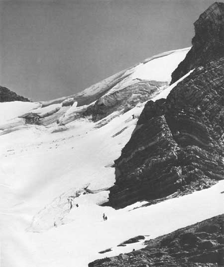
| Aerial view, southeastward, of the upper part of Sperry Glacier, July 27, 1969. Part of Gunsight Mountain is visible at the right. Photography by Mel Ruder, Hungry Horse News, Columbia Falls, Montana. Published through the courtesy of the photographer. |
Recorded observations, during approximately 80 years of the shrinkage of the two largest glaciers in Glacier National Park
UNITED STATES DEPARTMENT OF THE INTERIOR
CECIL D. ANDRUS, Secretary
GEOLOGICAL SURVEY
H. William Menard, DirectorLibrary of Congress Cataloging in Publication Data
Johnson, Arthur, 1903-
Grinnell and Sperry Glaciers, Glacier National Park, Montana
(Geological Survey Professional Paper 1180)
Bibliography: p. 29
Supt. of Docs. no.: 11916:
1. Grinnell Glacier, Mont. 2. Sperry Glacier, Mont. 3. Glacier National Park I. Title II. Series: United States Geological Survey Professional Paper 1180
GB2425.M9J63 551.3'12'0978652 80-607150
CONVERSION FACTORS FOR METRIC EQUIVALENTS
| English unit | Metric unit | |
| To convert |
Multiply by |
To obtain |
| Inch | 2.54 | Centimeter |
| Foot | .3048 | Meter |
| Mile | 1.609 | Kilometer |
| Acre | .4047 | Hectare |
| Acre-foot | 1,233.00 | Cubic meter |
| Square mile | 2.590 | Square kilometer |
| °Fahrenheit | Subtract 32 and divide by 1.8 | °Celsius |
| <<< Previous | <<< Contents >>> | Next >>> |
pp/1180/contents.htm
Last Updated: 08-Jul-2008