
|
Geological Survey Bulletin 611
Guidebook of the Western United States: Part A |
ITINERARY
|
|
SHEET No. 16. (click on image for an enlargement in a new window) |
|
Central Park. Elevation 4,324 feet. Population 178.* St. Paul 1,047 miles. Manhattan. Elevation 4,255 feet. Population 570.* St. Paul 1,052 miles. Logan. Elevation 4,114 feet. Population 481.* St. Paul 1,057 miles. |
At Central Park the railway crosses West Gallatin River and on the left is a beautiful rolling upland country, every acre of which is under good cultivation. This upland is on the lake beds and rises toward the southwest, with the rise of the beds composing it, to a height of at least 500 feet above the railway. Near Manhattan (see sheet 16, p. 112) a branch line turns to the left (south) to Anceney. The plain continues northwestward almost as far as Logan, and throughout that distance the only rocks which are exposed are the gravel and sand of the river flood plain and the slightly more indurated materials of the old lake beds.
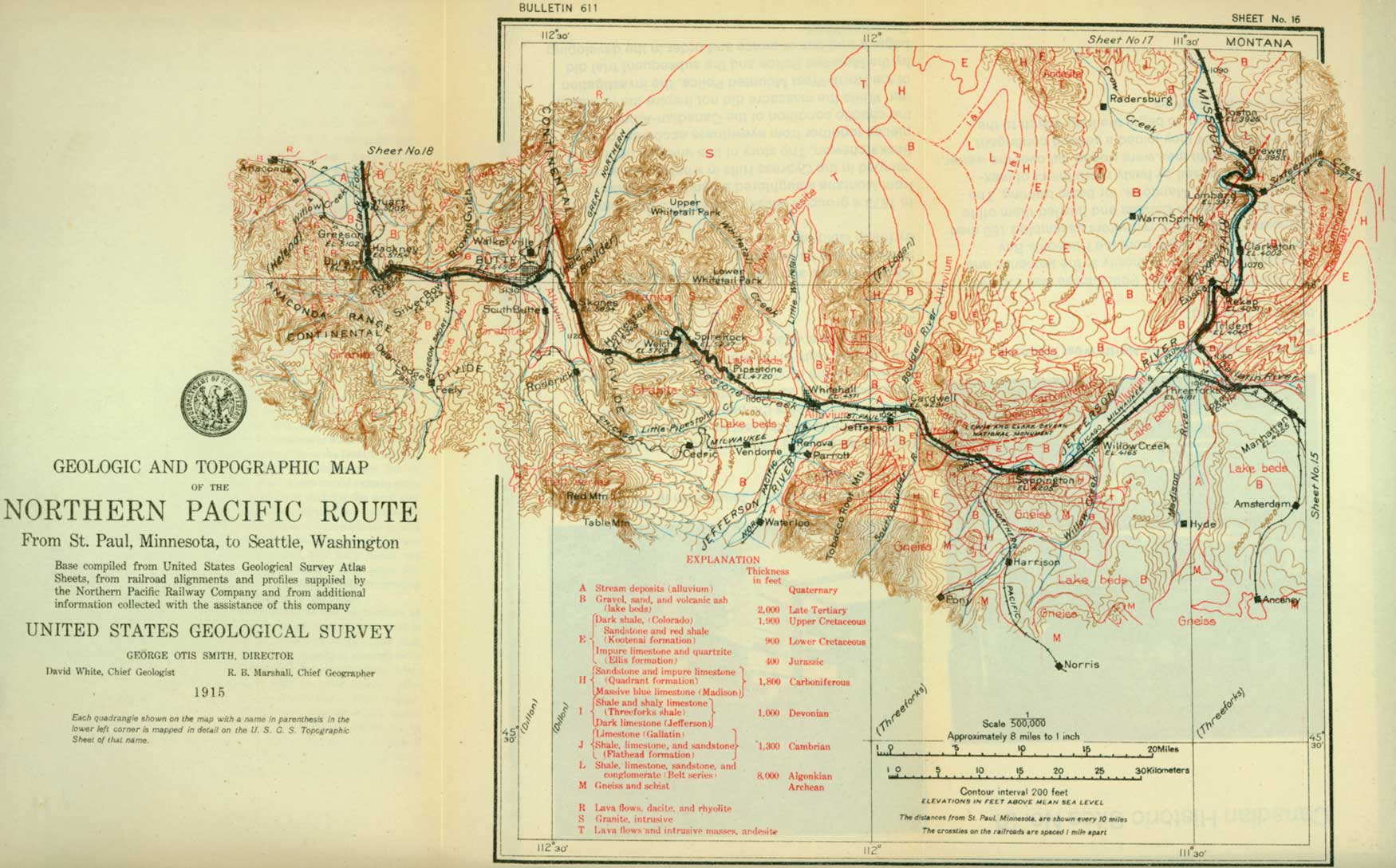
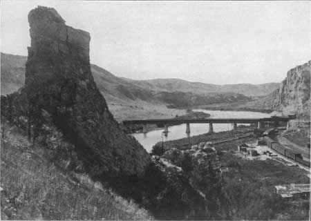
Near Logan the whole of the Paleozoic succession present in this region is exposed across Gallatin River, on the north. The first rocks to be seen are those of the Belt series (Algonkian), which are so far away that their character can not be determined from the train, but the traveler, in the course of his journey farther west will see this series in many places and will have opportunity to study it at close range. The rocks across the river near Logan constitute the southeastern limb of a great synclinal trough (see fig. 25, p. 116) and therefore dip toward the northwest, or away from the observer. The next system above the Algonkian is the Cambrian, which is represented by two formations. The lower one (Flathead) is composed mostly of shale and sandstone, but includes a layer of massive limestone through which the railway passes in a deep cut near milepost 164. The Gallatin limestone, overlying the Flathead formation, makes a prominent bluff across the river which can be seen just as the train enters the yards at Logan. The section as seen from the station is represented in figure 18. The Gallatin limestone, at the extreme right of the section, is generally light blue or gray and is easily distinguishable from, the overlying Jefferson limestone (Devonian), which is dark and more resistant. The Jefferson limestone is one of the most conspicuous members of the section, for it is much darker than any of the other limestones, and as it lies directly below a fairly soft shale it forms a distinct ridge or prominent spurs. It is overlain by the Threeforks shale, which is conspicuous only in that, as it is softer than the limestones on either side, it forms valleys or ravines. Overlying the shale is the massive bluish-gray Madison limestone, which forms the bluff opposite the station and extends westward on both lines of the railway for a distance of at least half a mile.
|
| FIGURE 18.—Southeast side of the great synclinal basin north of Logan, Mont., as seen from the station. |
From Logan to Garrison the Northern Pacific has two lines, the original line turning to the right and running by way of Helena and the other keeping to the left by way of Butte. A description of the Helena line begins on page 116.
LOGAN TO GARRISON BY WAY OF BUTTE.
West of the station at Logan a few outcrops of Madison limestone occur near the track, but these are soon passed; and then the only surface features visible from the train are the broad flood plain of Gallatin River on the north and a bluff composed of Tertiary lake beds on the south. The character and composition of these beds and also of similar beds found in most of the other broad valleys of the mountain region are well shown by the bluffs on the east side of the valley of Madison River and can be seen by looking back after passing milepost 3. Here the material is largely sand and the lower layers exposed along the terrace front are hardened into real sandstone. The coarse sand above is less coherent and is being used in the manufacture of cement blocks. Farther south the sandstone is limited to the upper part of the terrace, and all the material below consists of white volcanic ash.
|
Threeforks. Elevation 4,081 feet. Population 674. St. Paul 1,063 miles. |
At milepost 5 the railway crosses Madison River.1 On the right (north) is the thriving town of Threeforks, situated near and named from the three forks of the Missouri. This place was first visited in 1805 by Lewis and Clark,2 who named the easternmost branch for Albert Gallatin, Secretary of the Treasury; the middle branch for James Madison, Secretary of State; and the largest and westernmost branch in honor of President Jefferson. The western branch, by reason of the volume of water and its greater length, is generally regarded as the real head of the Missouri.
1Fifty miles to the south Madison River cuts through gneiss in a narrow, rocky canyon. Here the river has been dammed and two hydroelectric plants installed, which develop about 15,000 horsepower and supply current to the cities of Butte, Bozeman, Livingston, and Billings; to placer mines in the vicinity of the plant; and to the cement mill at Trident, below Threeforks. A dam is under construction on Madison River which will store about 350,000 acre-feet of water in what is known as the Hebgen reservoir. It is estimated that this reservoir when completed will increase the total present development along Madison River by about 23,000 horsepower.
2When Lewis and Clark reached this point in their journey up the Missouri River, they were greatly worried by their inability to find a pass through the mountains or to meet Indians from whom they might obtain information regarding such a pass. They knew not where the river would lead them, nor whether the mountains that lay in their pathway could be crossed. The reader may obtain some conception of the difficulties that beset them by reading a brief quotation from their notes written while they were at Threeforks:
"We are now very anxious to see the Snake Indians. After advancing several hundred miles into this wild, mountainous country, we may soon expect that the game will abandon us. With no information of the route, we may be unable to find a passage across the mountains when we reach the head of the river—at least such a pass as will lead us to the Columbia. Even are we so fortunate as to find a branch of that river, the timber which we have hitherto seen in these mountains does not promise us any fit to make canoes, so that our chief dependence is on meeting some tribe from whom we may procure horses. Our consolation is that the southwest branch [Jefferson River] can scarcely head with any other river than the Columbia, and that if any nation of Indians can live in the mountains we are able to endure as much as they can and have even better means of procuring subsistence."
It was here that Sacajawea, the Indian woman who was the real guide of the expedition, found the place of her capture several years before. In recognition of her services in the early exploration of the country a bronze tablet, presented by former Senator W. A. Clark, has recently been placed on a large bowlder in the public park of Threeforks by the Montana Daughters of the American Revolution.
|
Willow Creek. Elevation 4,165 feet. Population 333.* St. Paul 1,070 miles. |
Beyond Threeforks the railway leads up the broad flood plain of Jefferson River and is paralleled by the Chicago, Milwaukee & St. Paul Railway as far as Cardwell. The flood plain is composed largely of sand and gravel washed down from the mountains on either side, consequently the soil is thin and the region not well adapted to farming. At Willow Creek, however, soft lake beds cover the coarse gravel, and the country is more fertile.
Beyond Willow Creek the railway approaches the bluffs on the south side of the valley, which consist of quartzite, shale, and limestone, of the Quadrant formation, backed by a higher ridge of Madison limestone. At milepost 17 the river flows in a narrow canyon through a point of this limestone which projects into the valley, and the two railways follow the passageway that the river has cut through the hard rock.1
1It is by no means uncommon to find that a river has cut its way through hard rock which it might have avoided by pursuing a slightly different course. The explanation for Jefferson River lies in the fact that when the present course was established the valley was not cut to its present depth, and the hard limestone that now seems like a barrier in the pathway of the stream lay concealed below the surface. Under such conditions the stream was free to meander from side to side of its flat-bottomed valley, and one of its loops was located directly above the limestone ledge. In time the stream cut a deep channel in the soft rocks of its valley bottom and revealed the hard rock beneath, but it was confined by walls of its own slow cutting and could not dodge aside when it encountered a more resistant rock. As the channel was worn lower, the stream became intrenched so deeply in this hard rock as to make direct escape impossible, even after the whole aspect of the country had been changed by erosion and easier routes which the river might have taken had become evident.
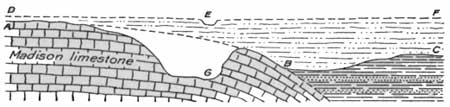
FIGURE 19.—Diagram to explain the course of Jefferson River west of Willow Creek, Mont. The river cut through soft lake beds (DEF) to hard limestone (AB), but was then so deeply intrenched that it could not avoid the hard rock. The situation is represented by figure 19, in which ABC represents the cross section of the valley which one sees on looking west, with the limestone ridge AB projecting into it from the left. When the present location of the river was determined it was flowing on the top of the lake beds, on a surface represented by DEF which was smooth and with no irregularities to prevent the stream flowing in any part of the valley. Let us suppose that it was located at E; then some change occurred, such as an elevation of the land or an increase in the volume of water, either one of which would give the stream greater cutting power, and it began to trench the soft material over which it flowed. As it cut deeper it came into contact with the limestone, but the stream was intrenched in its course and so maintained its position, cutting its way down to G, its present level.
The soft rocks upon which Jefferson River assumed its present course are the Tertiary lake beds, which probably filled the valley to a depth of several hundred feet.
|
Sappington. Elevation 4,205 feet. St. Paul 1,076 miles. |
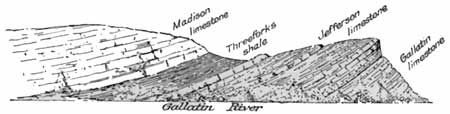
From Sappington a branch line continues up the south side of the river for a mile or so and then turns up Antelope Creek to Norris and Pony. A short distance beyond the station the Northern Pacific crosses the St. Paul line, and from this point on through the canyon the Northern Pacific is on the north side of the river. About 2 miles above Sappington the river again cuts through a ridge of the hard rocks which project from the great mass on the left. In this canyon the formations composing the earth's crust have been greatly disturbed and tilted up on edge, but it is not easy to understand just how the originally horizontal beds of limestone and quartzite were forced into their present positions.1 Here again the stream has cut a canyon across a spur of hard rock projecting from the left, and here, as below Sappington, the stream could have avoided the obstruction by keeping on the soft rocks farther north.
Beyond this canyon the river flows through an open valley composed of Jurassic and Cretaceous rocks which the traveler will hardly be able to distinguish from the train. At milepost 26 he enters the deepest and most picturesque canyon on this part of the line. The rocks in this canyon are in the form of a great anticline, as shown in figure 20, but the fold is so large and so badly broken that its form is difficult to determine. This fold has been produced by pressure from the north so great that the rocks have broken, as shown in the diagram, and the Paleozoic formations on the north have been pushed over the Cretaceous formations on the south. Such a break is called an overthrust fault.
|
| FIGURE 20.—Section of great anticlinal fold near Lime Spur, Mont., as seen from the Northern Pacific Railway, looking west. |
1The peculiar relations of the several formations, as seen in the small canyon west of Sappington, could have been produced only by folding and faulting, which were the results of strong forces that crowded the rocky layers into this region from both the north and the south. This caused them to buckle along east-west lines, much as a pad of paper will buckle when grasped by the hands along two opposite opposite edges and compressed. The great compression which affected the rocks in this canyon produced at least three upward folds or anticlines, and as the movement was strongest from the north the folds were pushed over toward the south. As the pressure continued the rocky folds were broken, crushed, and crowded together into the positions shown on the west side of the river.
The main part of the arch visible from the train is composed of Madison limestone, which is first seen from a westbound train at a point between mileposts 25 and 26. As shown in the diagram, the limestone at this place is only the broken fragment of the south side of the fold which has been nearly removed by the fault that crosses at the small loading platform on the right. The limestone at this place is overturned, dipping to the north, and it is probable that if it could be followed downward it would be found to grow thinner (beveled) and finally to be cut off altogether by the fault.
At milepost 26 the Madison limestone gives place to the underlying Threeforks shale (Devonian). The upper shaly part of this formation is covered so that it can scarcely be seen, but the lower part, consisting of a conglomerate composed largely of red granite debris, is seen in rugged cliffs on the east side of the track.
In the high mountain on the right there is said to be a wonderful cave in the Madison limestone, which has not yet been thoroughly explored. A quarter section (160 acres) of land, including the cave, was set aside by President Roosevelt on May 11, 1908, as the Lewis and Clark Cavern National Monument. The cavern, however, is so nearly inaccessible that it has been visited by only a few of the more hardy travelers.
|
Lime Spur. Elevation, 4,260 feet. St. Paul, 1,084 miles. |
Opposite Lime Spur, 8 miles west of Sappington, the beds of Madison limestone outcrop along the canyon wall like great white ribs, making some of the most rugged scenery to be found on the road. The limestone is quarried extensively at this place and shipped for the manufacture of cement.
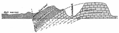
West of Lime Spur the Madison limestone gives place to the Quadrant formation, which is well marked by the bright-red color of some of the limestone and shale beds that it contains. Beyond this band of bright color is a small exposure of Jurassic rocks which are cut off by an immense overthrust fault, shown in figure 20. This fault separates the rocks already described from conglomerate and argillite (slate or hardened shale) of the Belt series (Algonkian). The railway follows the west base of a mountain slope of this formation for nearly a mile and then enters the broad valley at the junction of Boulder and Jefferson rivers.
|
Cardwell. Elevation 4,291 feet. St. Paul 1,088 miles. |
On looking back from the vicinity of Cardwell one is impressed with the abrupt ending of the broad valley a little east of this place and the mountainous barrier that has apparently been thrown across the pathway of the stream. It is evident that either the mountains have risen across the valley, or the valley about Cardwell has been depressed far below its former level, or perhaps both of these movements have taken place. As the river has succeeded in cutting a canyon through the uplifted mass, the movement must have been very slow, else the stream would have been ponded and found an outlet in some other place.
|
| FIGURE 21.—Diagram of braided stream. |
The valley of Jefferson River, although little above water level, is very fertile, and good crops are raised in the vicinity of Cardwell. In flowing through this flat-bottomed valley the river is not confined to a single channel but breaks up into a number of channels, which in turn branch and unite in a complex and confusing manner. Such a system of interlacing channels is called a braided stream. It is caused by the slight fall of the stream, which prevents it from carrying away all the sediment swept in by the numerous tributaries. This material chokes the stream and forces it to spread into numerous shallow and shifting channels, resembling the strands of a braid, as shown in figure 21.
The Tobacco Root Mountains are prominent on the south, at Cardwell, and Bull Mountain on the north, though the latter is less conspicuous than the former. The end of Bull Mountain nearest the railway is composed of the Belt series, with the Tertiary lake beds lapping in around its base. The geology of the Tobacco Root Mountains is too complicated to describe here, and the rocks are so far distant that they can not be recognized from the train.
The railway for a long distance west of Cardwell is on an island in the braided stream, but beyond milepost 36 it crosses to the mainland, and Jefferson River is seen no more in the westward journey. At this place the railway leaves the trail of Lewis and Clark, for they followed up the main river toward the southwest, whereas the Northern Pacific strikes across the range to the west, though it means a climb that even to the modern, high-power locomotive is a severe test. The St. Paul road also turns to the left, but merely to seek another pass in the same range ahead.
|
Whitehall. Elevation 4,371 feet. Population 417. St. Paul 1,095 miles. |
At Whitehall a branch of the Northern Pacific turns to the left, going up the valley of Jefferson River to Twin Bridges and Alder. The town at the end of the line was named from Alder Gulch, which was one of the most noted placer camps in the years immediately following its discovery in 1863. It is said to have yielded at least $60,000,000 and is still producing in a small way. Alder Gulch lies near Virginia City, at one time the capital of Montana. West of Whitehall the road begins the ascent of about 2,000 feet to Homestake Pass, on the Continental Divide 23 miles away.
|
Pipestone. Elevation 4,720 feet. St. Paul 1,012 miles. |
Just beyond Whitehall the low hills on both sides of the track are composed of soft lake beds which are particularly well exposed just west of Pipestone. In the valley some distance to the south there are hot springs and a hotel. West of Pipestone the cuts along the railway show a fine-grained, dense igneous rock (andesite). This is part of a large body of similar rock that lies to the right (north) of the railway and east of the great mass of granite that forms the Continental Divide. Most of the andesite was poured out over this region as lava when the surface was very different from that which the traveler sees to-day, but some of it was intruded from below into the older sedimentary rocks. The volcanic activity which gave rise to the andesite took place long before the granite was intruded, as is proved by the fact that near Pipestone the granite includes fragments of the older rock which were broken off and mixed with the molten granite as it ascended through a fissure in the rocky crust of the earth.
Near milepost 48 the railway enters the great area of granite which extends northward along the range to Mullan Pass, west of Helena. The granite (quartz monzonite) came up from below in a molten condition, forcing the rocks asunder or melting them as it came. It probably did not reach the surface, but since it cooled and solidified it has been exposed by the streams, which have removed the overlying rocks and cut deep ravines in the granitic mass.
As the slope is too steep for a direct ascent, the road winds out and in, around projecting spurs, and up into the heads of valleys, but ever climbing toward the top. On the hills and upland the slopes are smooth and gentle, but in the gulches they are rocky in the extreme.
Near milepost 50 the traveler, by looking ahead on the left, can see a bare dome of granite, known as Spire Rock, the base of which the train will pass farther up the grade. Other knobs or domes of gray granite appear from time to time, standing above the general surface. These landmarks resemble the domes of Yosemite Valley, which are formed of similar rock. Such domes and indeed the great number of rounded forms which the granite assumes on weathering are due to the facts that the corners and edges are more exposed to the attacks of weather than broad surfaces are, and that this rock, which is popularly regarded as the type of stability, readily disintegrates or falls to pieces on exposure to the atmosphere. At many places along the track the granite has been reduced by weathering to fine fragments called "sand."
The general slope leading to the summit seems to be an old surface, on which the granite is deeply decayed, indicating long exposure to the weather, but the ravines, which have been cut more recently, are jagged and irregular. The difference in the two surfaces may be seen near milepost 56, where the railway leaves the smooth surface of the upland and enters a gorge which is cut below the general level and which is marked by blocks of all sizes and shapes, including domes, towers, and pinnacles that seem to be scattered over the ground in hopeless confusion.
This combination of smooth upland and rocky canyons continues to the top, which is remarkably free from rugged peaks. Although there is a short tunnel here, the real summit of the mountain is only about 100 or 150 feet above the railway track.
|
Homestake. Elevation 6,345 feet. St. Paul 1,118 miles. |
This is the backbone of the continent, the height toward which the train has been climbing since leaving Missouri River at Mandan. The traveler may be disappointed in the Continental Divide, for it is no more conspicuous than many of the other ranges in sight. In fact, the Rocky Mountains are a great complex of mountain ranges, no one of which dominates the others to any extent. On the west side of the Homestake tunnel can be obtained a better realization of height, for the descent to Butte is made along a rugged, mountain side, and one can look down to the left 1,000 feet to the valley, seemingly almost vertically below.1 (See Pl. XVI.)
1The difference in the appearance of the two sides of the Continental Divide is very striking. On the east side the slopes are gradual, so that the railway can follow almost directly up the old smooth slope, but on the west the slope is so precipitous that the road must be graded along the rocky mountain side for 8 or 9 miles in order to get down to the valley floor. So steep and regular a front bordering a broad, flat valley suggests some other mode of origin than erosion, which is the normal agency in the production of mountains and valleys. It gives the impression that this range, instead of owing its relative height to the carving out of the valley by rain and streams, is really separated from the low land by an actual break in the rocks and has been lifted bodily to its present position, or the valley has been depressed with reference to the mountain. If the rocks along the mountain front south of Butte are examined, evidence will be found to show that there has been recent movement in them and a break (fault) or series of breaks along the west face which allowed the great block of strata on the east side of the fault to be raised at least 1,000 feet with reference to the strata on the other side. The steep mountain front is therefore the cut edge of a great block of rock that has been tilted gently to the east, and the time since it was raised to its present position has not been sufficient to permit the streams to cut deep ravines on it.
The tilting and lifting of this block of strata have disarranged many of the streams, causing some of them to flow in opposite directions from those which they pursued prior to the uplift. It seems probable also that the block west of the fault was depressed at the same time, for it is difficult to understand how the headwaters of Silver Bow Creek could be ponded and produce the flat that can be seen from the train, unless it were the result of the downward tilting of the block west of the fault. The condition is illustrated by figure 22, in which the cross profile of the range before the faulting occurred is represented by the line ABC. The surface around Butte showed little relief, the mountain north of Homestake Pass being only a few hundred feet high. Then came the break along the line indicated by the arrows, the part on the right rising about 1,000 feet. Now the mountain top, instead of being at B, is at D, more than 1,000 feet above the valley.
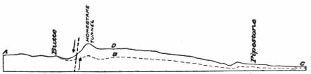
FIGURE 22.—Diagram of Continental Divide east of Butte, Mont. Before faulting occurred the divide, as shown by the broken line ABC, was an upland of slight relief and no higher than Butte is to-day. Although the main movement that raised the Continental Divide to its present position is supposed to have ceased, there still appears to be slight movement in the rocks under Butte. Many underground water pipes have been broken, and considerable difficulty has been experienced from the irregular settling of foundations. For a long time these slight movements have been attributed to the extensive mine workings beneath the city, but on close study it was found that water pipes were broken in parts of the town far removed from any mine. This suggests that there may be movement along some of the old fault planes. The United States Geological Survey has run some very exact levels and has set a number of bench marks, so that in the future it can be told positively whether the rocks under the town are moving and, if so, at what rate.
|
Butte. Elevation 5,490 feet. Population 39,165. St. Paul 1,128 miles. |
The train winds in and out around the spurs of the mountain, plunging through deep cuts and speeding over high trestles. In the course of a few miles the city of Butte comes into view on the side of a barren hill. Its general appearance is most desolate. Bare, brown slopes, burnt and forbidding, from which all vegetation was long ago driven by the fumes from the smelters, rise from an almost equally barren valley. The slopes, even in the city, are gridironed by railway tracks leading to the different mines, and great mine buildings, tall smokestacks, steel hoist frames, and the heaps of gray waste rock from the mines are the most conspicuous features of the landscape. West of the city is the sharply conical hill, Big Butte, from which the city takes its name. If the traveler enters Butte in the evening he may obtain a beautiful view of the lights of the city twinkling through the smoke and haze, but in the daylight all beauty disappears.
|
| PLATE XVI.—VIEW LOOKING WEST FROM HOMESTAKE SUMMIT, MONT. The roadbed is cut in granite along the steep mountain side nearly 1,000 feet above the bottom of Silver Bow Valley. The Continental fault is at the bottom of the slope. Photograph by Haynes, St. Paul, Minn. |
When the smelters were pouring out their destructive fumes there was not a spear of grass nor a green leaf visible, but now most of the ore is smelted at Anaconda and Great Falls, and the valley is gradually recovering some of its vegetation. Of the city itself perhaps no better description can be given than that contained in "Along the scenic highway," a pamphlet issued by the Northern Pacific Co.:
Butte is unique among the cities of the world, * * * possessing all the united wealth of its tremendous copper deposits, with thousands of well-paid miners. With a large and growing trade in commercial lines, it is an odd and interesting combination of frontier mining camp and modern city, smoke-begrimed manufacturing point, and an orderly, well-kept residential center. It is a city of glaring, violent contrasts, where money seems quite the easiest thing to obtain, where men work furiously and spend the proceeds of their labor with open hand, where the fine instincts of modern city life struggle constantly with the old order of things, and where the mining camp and twentieth-century municipality have been mixed into one rugged mass but have not yet quite blended. Butte boasts with reason that it is the greatest mining camp in the world and may with equal reason boast of its achievement as a modern city.
The positions of the famous copper mines are indicated by the great shaft buildings and tall smokestacks in and about the town. Underground the rocks are honeycombed with workings, and day and night, without cessation, the work goes on at depths which in some of the mines reach 3,000 feet. Up to the present time the value of the metal output of the district has reached the enormous sum of over $1,000,000,000. The ore is found in the granite, but the highly mineralized rocks are confined to an area only a few square miles in extent. The mining conditions are described below by B. S. Butler.1
1Butte was at first a placer camp, and the district was named the Summit Valley district on account of its nearness to the Continental Divide. This is still the official name of what is commonly called the Butte district. Gold was discovered in gravel near the present site of Main Street in 1864, and in the next few years the district produced gold to the value of about $1,500,000. While the placers were being operated, efforts were made to work the quartz veins for silver, but without success. About 1875, however, attempts to work these ores were renewed, and the Dexter 10-stamp mill was erected, but important production did not begin till 1876, when the mill was completed by W. A. Clark, later United States Senator from Montana. About the same time Marcus Daly arrived in the district and began operations in the Alice mine. The camp developed rapidly, and for many years these two men were prominent in mining enterprises in this district. The district continued to be a large producer of silver ore until the decrease in price of that metal in 1893 caused many companies in Butte, as elsewhere in the West, to cease operations.
The presence of copper minerals was noted in the district probably as early as placer gold or the silver veins, but under existing conditions there was little inducement for prospecting the copper veins. Nevertheless some unsuccessful attempts to smelt the copper ores were made in 1866, and early in the seventies some copper ore was hauled 400 miles to Corinne, Utah, whence it was shipped by rail to smelters in other parts of the country.
The first successful smelter in this district was put into operation about 1880 by the Colorado & Montana Smelting Co., and this was followed by a rapid development of the copper industry. Production was greatly stimulated in 1881 by the completion of the Utah Northern Railroad (now Oregon Short Line) to Butte, followed a few years later by other railroad connections. The first smelting plants were near Butte, but in 1883 the Anaconda Co. began the construction at Anaconda, in Deer Lodge Valley, about 27 miles from Butte, of a plant which has become one of the largest copper smelters in the world, its capacity being 12,500 tons of ore a day. It was rebuilt in 1902 at a cost of $7,500,000. About 1892 the Boston & Montana Co. erected a plant having a daily capacity of 4,500 tons at Great Falls, where the water power of the Missouri is available. At present there is but one smelter near Butte, that of the East Butte Copper Co.
In recent years the development of large bodies of zinc ore at Butte has led to the construction of plants for its concentration, and the mill of the Butte & Superior Co. has successfully demonstrated the economic importance of these ores.
The efforts to apply to the complex and enormously valuable veins at Butte that provision of our mining law which permits the owner of the upper part (apex) of a vein to follow his ore under the surface of adjoining claims has burdened the district with protracted and costly litigation, to an extent probably unequaled in the history of mining in other parts of the world.
The Butte district has yielded more copper than any other district in the world, the total output to the close of 1913 being 6,154,196,000 pounds, or about one-third of the total copper output of the United States. It has produced also $26,268,500 in gold, 275,119,000 ounces of silver, 11,300,000 pounds of lead, and 181,540,000 pounds of zinc. The values of these metals are as follows:
Gold $26,268,500 Silver 191,765,300 Copper 865,794,300 Lead 513,500 Zinc 12,093,600
1,096,435,200A large part of the output has come from an area of but a few square miles, which so far as value is concerned, has undoubtedly been the most productive metalliferous area of its size in the world.
In recent years some arsenic has been recovered from the smelter fumes and small quantities of the rarer metals have been recovered in the electrolytic refining of the copper.
The metallic deposits at Butte occur near the western border of an area of the granitic rock technically known as quartz monzonite. Near Butte this rock has been intruded by dikes of light-colored siliceous rocks known as aplite and rhyolite. The Big Butte and a large area northwest of it are composed of rhyolite that has risen through openings in the older rocks and covered the surface.
The rocks in the vicinity of Butte have been broken by many faults and fissures, the greatest of which is the Continental fault, described on page 107. Long before the break of the Continental fault and soon after the intrusion and solidification of the granite, the rocks were broken by one series of fissures and faults having a general northwesterly direction and another series having a general northeasterly direction. Water carrying minerals in solution rose along these fissures and deposited the ore in part as a filling of the fissures and in part as a gradual replacement of the rock adjacent to the fissures.
The composition of the veins shows a progressive change in metal and mineral composition from a central area outward. The central area contains mainly copper ores. These grade outward into ores containing increasing quantities of zinc, lead, and silver, together with abundant manganese minerals, and chewing a decrease in copper, until in the outer zone the ores are valuable chiefly for their silver, gold, and zinc content.
The veins at the surface have all been highly oxidized, and from some the copper has been leached to depths of several hundred feet. In mining some of the veins have been followed to a depth of 3,000 feet and show little change in mineral composition after the first few hundred feet. In fact, in many veins the change in depth is less striking than in an equal distance horizontally.
In the early days of copper mining in the district the ores extracted were of high grade and were smelted direct. Later large bodies of low-grade ores were mined and concentrated at the plants at Anaconda and Great Falls, and the resultant concentrates smelted to recover the metal. More recently a plant has been constructed at Anaconda for leaching the tailings from the concentrating plant to recover the copper lost in the operation. A plant has also been placed in operation at East Butte, by the Butte & Duluth Co., to leach the copper from oxidized ores. A portion of the copper from Butte is electrolytically refined at Great Falls, but the greater part is sent to the Atlantic seaboard for refining. The water from the mines carries a considerable quantity of copper in solution, the metal being recovered by precipitation on old iron.
In the early days Butte, like the other mining camps of Montana, suffered greatly from the lack of transportation facilities, as the only way to get supplies was to have them brought up the Missouri or Yellowstone River as far as steamboats could come and then by team over the mountains to the camp, and the metals produced had to be sent out by the same slow, expensive way. The city is now served by five railways, three of which are transcontinental lines.1
1The railroads were naturally anxious to get the trade of such places as Butte and made every effort to reach them at the earliest moment possible. While the Northern Pacific was pushing its line from the east and from the west, the Utah Northern, now the Oregon Short Line, built into the district from the south, the first train arriving December 21, 1881. This road gave direct connection with the Union Pacific. Although the Northern Pacific had through trains running by way of Helena in 1883, not until 1888 did it make a vigorous effort to reach Butte. At the same time the Montana Central Railroad Co. was organized, and both it and the Northern Pacific began to build parallel lines from Helena to Butte. There was great rivalry in the construction work, but as the Montana Central, now the Great Northern, succeeded in getting its line though first, the Northern Pacific line was abandoned after it had been built as far as Boulder. The Montana Central line from Helena to Butte was opened for traffic on July 12, 1888.
The Northern Pacific, however, did not give up the project of reaching Butte and a few years later built a line from Logan, giving the camp a direct outlet to the east, but still there was no main line through the camp. On September 8, 1893, the Montana Union Railroad was completed by Union Pacific interests from Butte to Garrison, thus giving a direct outlet to the west. This line was used jointly by both the Union Pacific and the Northern Pacific for a few years, but eventually it passed into the hands of the latter, and it is now one of the main lines of the system.
After leaving Butte the railway follows down Silver Bow Creek, which received its name from a party of prospectors who, in 1864, reached the valley in the vicinity of Butte. They had an extended discussion regarding the best name for the stream, and while they were talking the clouds broke away and the sunshine falling on the creek as it circled around the mountain suggested the name Silver Bow. At that time the creek may have looked like a silver bow, but now there is little similarity.
|
Silver Bow. Elevation 5,345 feet. St. Paul 1,135 miles. |
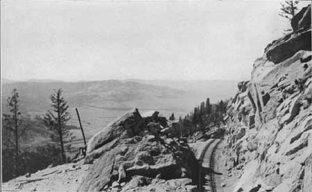
The valley is wide, the immediate hills are low, and the slopes are gentle and rolling. At Silver Bow station, 7 miles from Butte, the Oregon Short Line (Union Pacific) turns to the left (south) and after a short climb crosses the summit at Deer Lodge Pass. Beyond Silver Bow station the valley continues open for a distance of 4 miles to a point where the stream enters a very narrow, rugged canyon cut in massive rhyolite, a volcanic rock that covers much of the country west of Butte. The rock when freshly broken is nearly white, but under the influence of the weather it turns to a deep, rich red, which gives a pleasing relief to the somber-gray color of the granite to the east. The Butte, Anaconda & Pacific Railroad (recently electrified) and the Chicago, Milwaukee & St. Paul and Northern Pacific railways also occupy the canyon, which, on account of its narrowness, is very much congested. (See Pl. XVII, p. 107.)
|
| PLATE XVII.—SILVER BOW CANYON, MONT. Recent gorge cut by Silver Bow Creek, which as forced to take this course by the filling of its old valley to the north by lake sediments. Cliff of red lava (rhyolite) on the right. Photograph by Butte Photo View Co., Butte, Mont. |
Aside from its ruggedness and picturesqueness this canyon has an added interest because it owes its origin to the filling of the original valley on the north with lake sediment and the cutting of a new course by the stream, similar to that of Jefferson River, described on page 101. After the disappearance of the lake Silver Bow Creek came into existence, and on the swampy bottom of the lake it meandered broadly. In its windings it had assumed its present position, when, through the elevation of the land, it gained cutting power and began to deepen its channel. In doing so it encountered the rhyolite, but it continued to cut, and the canyon is the result.
|
Durant. Elevation 5,174 feet. St. Paul 1,142 miles. Stuart. Elevation 5,006 feet. St. Paul 1,146 miles. |
At Durant the train emerges from the canyon into a valley much broader than the one at Butte or Silver Bow. This, the renowned Deer Lodge Valley, is much too large to have been carved by the stream now occupying it. The eastern traveler has doubtless noticed that the valleys in this region are generally different from those with which he is familiar. Valleys that are the result of stream erosion have generally a width that is roughly proportional to the size of the stream, and as a rule they decrease in size toward the head of the stream. In the northern part of the Rocky Mountains many of the larger valleys are out of proportion to the size of the streams occupying them, and hence it does not seem probable that they were formed alone by the erosive action of the streams.1
1As the origin of many of the broad valleys of the northern Rocky Mountains can not be attributed to erosion, it is manifest that they must have been produced by movement in the earth's crust, either the direct subsidence of the valley itself or the elevation of the surrounding mountain masses. Subsidence may have been accomplished in one of three ways, as illustrated by figure 23. In this diagram AB represents a section across a country with a hilly surface. A broad valley may be formed by a simple depression of the region, as illustrated by CE, in which the center D is depressed so much that the tops of the hills fall below drainage level. In such a case the depressed portion becomes a lake, and the lake is finally filled by waste material washed in from the surrounding region. Similar results may be produced by a fault, as shown in FG. Here the block of strata on the left has been tilted toward the right and at the same time dropped along the fault HI until a depression and lake are formed. The third and last case is that of a block of the earth's crust dropped between two nearly parallel faults, as shown in JK.
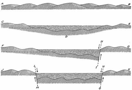
FIGURE 23.—Diagrams illustrating the ways in which the broad valleys of the Rocky Mountain region were formed. Deer Lodge Valley was probably produced by one of the three methods described above, but by which one can be told only by close examination and mapping.
The most conspicuous artificial object in the Deer Lodge Valley is the giant stack of the Anaconda smelter on the left (west), 350 feet high, from which issues a never-failing cloud of yellow smoke. The train does not pass close enough to Anaconda for the traveler to see much of the town, which is reached by a spur from the main line at Durant, but he is soon made aware of the effect of the waste waters from the concentration plant, which have flowed down the creek and killed most of the vegetation. Back of the smelter is Mount Haggin, named for James B. Haggin, who for many years was prominent in the mining industry of Butte. On the west side of the valley farther north is Racetrack Peak, which stands like a sentinel keeping guard over the entire valley. In 1910 Anaconda had a population of 10,134.
|
Warm Springs. Elevation 4,832 feet. Population 866.* St. Paul 1,153 miles. |
The town of Warm Springs (see sheet 18, p. 134) is built around a group of springs having a temperature of about 150° and affording a copious flow of water. The valley floor is several miles wide and is so flat that much of it is swampy. The hills on the right (east), about 500 feet high, are composed of light—colored clay and volcanic ash and are remnants of the Tertiary lake beds that once filled the valley at least as high as the top of these hills. These materials were deposited in a great lake, which occupied this valley at the same time that similar lakes occupied the Gallatin and Madison valleys to the east.1
1There is no more interesting subject in the geology of the mountain region of Montana than that of the lake beds. They imply conditions which at first sight seem to be anomalous—that is, extensive bodies of water in a rough mountainous region. As shown by the map of western Montana on sheet 18 (p. 134), lake beds have been found in practically every valley from the Yellowstone on the east to the Bitterroot on the west, but they have not been observed in many of the valleys north of Blackfoot River. It therefore seems fairly safe to assume that in Tertiary time lakes existed in nearly every mountain valley in the State. Many of the valleys that to-day are separated were doubtless connected though the canyons, but in such locations the material deposited in the lakes has been removed by the swiftly flowing streams. In other valleys the lake sediments that were once continuous have been separated by the breaking of the earth's crust into great blocks and the tilting of these blocks in various directions. Although the distribution of the materials that were laid down in these lakes indicates that many of them were connected, a study of the bones of animals that lived at the time and were buried in the mud and sand of the lakes indicates that the lake-forming conditions extended over a long period of time, some of the fossils being of Oligocene, some of Miocene, and some of Pliocene age. It is generally supposed, however, that most of the lakes were in existence in the Miocene epoch.
Lakes are abnormal features and have no place in the orderly development of a drainage system—that is, when a drainage system is established on the land there is no tendency in the action of the streams to form lakes, and when such features are formed they are the direct result of some interference with the work of the streams.
Most lakes in mountainous regions are due to the action of glaciers, either in scouring out rock basins or in damming valleys with moraines or with the outwash of sand and gravel from the front of the ice. If the old lakes of Montana were due to the action of ice, there would remain some trace of the glaciers that did the work and of the great dams which they must have built. Dams formed by landslides or lava flows would likewise leave some evidence of their existence, and they could not have been so extensive as to pond the water in all the principal valleys opening out on both sides of the range.
The wide extent of the lakes seems at once to rule out all local causes, so it is necessary to appeal to some cause that would have been operative throughout a wide region and that would have been adequate to produce such results. The great regional cause that is fully competent to pond rivers or produce lake basins is movement within the crust of the earth whereby one area is raised or depressed with relation to another. To the geologist the history of the earth, so far as it has been interpreted, consists of the record of an almost infinite number of such oscillations, with accompanying changes in the outline of the land and water.
A regional subsidence in the Rocky Mountains of Montana relative to the plains would readily account for the formation of lakes in all the valleys that were deep enough to lie below drainage level, and this will be accepted as at least a reasonable working hypothesis. According to this view a rough mountain region, probably as mountainous as it is to-day, was depressed hundreds or perhaps thousands of feet, until the streams failed to flow out in their accustomed courses, as the plains beyond were higher than the mountain valleys. The water from the rains and melting snows of the mountains soon filled the valleys until the water rose high enough to discharge over the plains country. Under such conditions there may have been many lakes or there may have been one large lake with ramifications in the valleys among the mountains.
Into the lakes thus formed the mountain streams poured mud, sand, and gravel, the mud being carried far out in the lake to settle as fine clay while the sand and gravel were dropped near shore. At least 600 feet of such material has been measured in some of the valleys, and probably it was originally much thicker. In some valleys the lakes were evidently filled and the surface became a swamp in which vegetation flourished and finally was converted into coal or lignite. Such beds have been found near Drummond and Missoula, along the line of the Northern Pacific Railway, and in the vicinity of the Glacier National Park, near the Great Northern Railway.
The climate of this region in the lake period, as indicated by the animals and plants that lived then, seems to have been much like that of central or southern Africa at the present time. The lake beds have not been searched thoroughly, but it is known that mastodons, horses, camels, and rhinoceroses roamed the hills in that far-off time, and that the filled basins were swamps in which flourished a luxuriant vegetation.
|
Race Track. Elevation 4,710 feet. St. Paul 1,160 miles. |
Beyond Warm Springs the valley of Clark Fork continues broad and flat; in many places near the stream it is swampy, but on the terraces on each side there is good farm land. On the left (west) from Race Track there are many deep canyons in the side of Flint Creek Mountain, through which glaciers, long past, have flowed down from the high summits even to the level of the main valley. This indicates that most if not all of the side ravines were cut before the glaciers were developed, and that since their disappearance there has been little change in the surface features.
|
Deer Lodge. Elevation 4,530 feet. Population 2,570. St. Paul 1,169 miles. |
At Deer Lodge terraces about 200 feet high are well developed on both sides of the valley. Apparently these terraces are remnants of the floor of the valley at a much earlier epoch, and possibly they may correspond with those observed on the east side of the valley near Warm Springs. North of Deer Lodge there is a terrace on the left, but the one on the right has disappeared and is replaced by low hills composed of soft Cretaceous rock.1
1The broad Deer Lodge Valley extends from Durant northwestward to Drummond, but its continuation beyond Garrison may not be apparent from the train.
The present condition and possible mode of formation of the valley are illustrated by figure 24, which represents a section along the railway from Durant on the south to Drummond on the north. As first formed, this valley was a great structural depression in the hard rocks, as represented by AB. In that basin sediment accumulated in Miocene time until the depression was filled, as shown in the diagram. The place where Garrison now stands was then near the middle of the basin, and probably only soft lake sediments showed at the surface from Durant to Drummond.
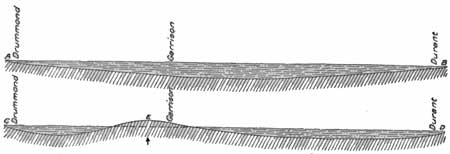
FIGURE 24.—Sections along Northern Pacific Railway between Durant and Drummond, Mont., showing probable mode of formation of Deer Lodge valley. At some later stage the floor of the basin was upraised midway between these two ends (see CD), so that the lake beds were exposed to erosion. The soft, incoherent lake sediments were soon washed away, and the stream trenched the underlying Cretaceous rocks to a depth of several hundred feet. The upraising of the middle part of the trough left a depression at either end, and at the present time these structural depressions are marked by broad valleys, such as can be seen at Deer Lodge and at Drummond. The presence of a broad valley connecting these two marked depressions can be realized only by a study of a contoured map or by a view from some commanding summit on the valley rim.
On account of the deformation of the old basin or trough, the immediate stream channel below Garrison for several miles is a veritable canyon in the Cretaceous rocks, but farther down it opens out into another wide expanse deeply covered by material laid down in the lake.
|
Garrison. Elevation 4,344 feet. St. Paul 1,180 miles. |
Garrison was named in honor of William Lloyd Garrison. Here the railway line through Butte unites with the original line of the Northern Pacific through Helena. The valley at Garrison is much narrower than it is above that place, the cliff on the west being composed of a volcanic rock (andesite) and that on the east of sandstone, shale, and beds of volcanic tuff 1 of Upper Cretaceous age.
1Tuff is a rock composed of fragments of lava, as a rule more or less distinctly bedded. These fragments may have been blown from a volcanic vent and may have settled down on dry land or in water. Even if deposited on land, the material may be so fine and loose as to be rapidly washed into the nearest body of water, there to accumulate as a stratified rock. Some of the finer-grained tuffs are largely volcanic ash—that is, the dustlike material produced when hot lava, thrown into the air, is blown into small particles by the explosive action of the steam that is an original constituent of all molten lava. Coarser tuffs may include angular blocks of lava many feet in diameter or rounded masses that have solidified as they flew though the air, and are known as volcanic bombs. Some tuffs include also much sedimentary material from the erosion of freshly erupted lavas.
[The itinerary west of Garrison is continued on page 127.]
LOGAN TO GARRISON BY WAY OF HELENA.
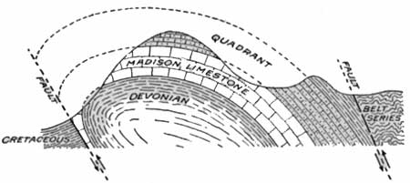
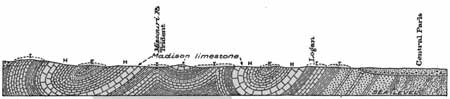
A short distance west of the station at Logan (see sheet 16, p. 112) the Helena line crosses Gallatin River and then follows this stream to its junction with the other rivers that form the Missouri. At the bridge and for a short distance beyond it the railway skirts the foot of a bluff of Madison limestone, but this rock dips below river level and beyond it the bluff is composed of the overlying Quadrant formation. Although the Quadrant resembles limestone it contains little of that rock, being generally composed of quartzite or flinty beds that are much harder and generally of a lighter color than the limestone. These beds in turn dip below water level and the rocky bluffs give way to a low rolling country with swampy land near the track. The railway follows the flat bottom of Gallatin River for some distance and thence more follows the cliffs of the Madison limestone, which is brought up from below water level by a great anticlinal fold. On the left (west) there is an extensive flat valley through which Gallatin, Madison, and Jefferson rivers flow on their way to join forces and form Missouri River. They unite at the entrance to the gorge which the combined stream has cut through the limestone and which the train is about to enter. This junction, known as Threeforks, has attracted the attention of every traveler who has entered this region since 1805, when it was first seen by Lewis and Clark. (See p. 100.) North of Threeforks the river has cut a canyon along a great arch or anticline which at the entrance to the canyon brings up to view only the Madison limestone, but the fold increases in magnitude northward (downstream) and lower formations are successively brought above water level. As shown in figure 25 this fold is not a simple arch, but the force which bent the rocks was so great that the fold was pushed over to the east, or overturned. The rocks were then broken or faulted, as shown in figure 26 (p. 117).
|
| FIGURE 25.—Section between Logan and Trident, Mont. The rocks, as seen from the railway, appear to be jumbled, but really they are bent into symmetrical folds. |
|
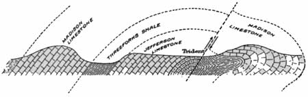
| FIGURE 26.—Faulted fold at Trident, Mont., looking northeast. |
|
Trident. Elevation, 4,045 feet. St. Paul, 1,063 miles. |
At Trident, in the canyon of the Missouri, there is a large plant for the manufacture of cement from the Threeforks (Devonian) shales,1 which is obtained from the crushed rock in the overturned anticline shown in the diagram. From Threeforks to Lombard, a distance of 15 miles, the Chicago, Milwaukee & St. Paul Railway parallels the Northern Pacific, on the opposite side of the river.
1The mill at Trident has a daily capacity of 1,600 to 1,800 barrels of cement and is modern in all its equipment, having been erected in 1910. Material most suitable for the manufacture of Portland cement contains approximately 75 per cent carbonate of lime, 15 per cent silica, and 5 to 7 per cent alumina and iron oxides, with very little magnesia and no sulphur. This combination is found in the Threeforks (Devonian) shale, which is quarried extensively along the east bluff of the river. The shale varies considerably in composition, that from the upper end of the cut being very limy and that from the lower end earthy and sandy. Rock is taken from all parts of the cut and then mixed until the proper proportions of the constituents are procured for the manufacture of cement. The raw material is burned in a revolving steel cylinder, with Red Lodge coal as a fuel. (For a description of Red Lodge coal see footnote on p. 82.) The coal, crushed until 95 per cent of it will pass though a 100-mesh sieve, is blown into the front ends of the revolving cylinders. It burns like gas, producing a temperature of about 3,000° F. The burned cement is crushed and mixed with a little gypsum to regulate the setting time and is then ready for the market.
For 5 miles beyond Trident the railway winds in and out on the flanks of the anticline, making a long cut in the Madison limestone at the sharp bend of the river. From this point the river turns back toward the southeast, cutting down through the formations, until it reaches the Belt series—the lowest in the section. Beyond this point the soft material of the lake beds obscures the hard rocks, and the hills formed by those rocks recede a mile or more from the river.
|
Clarkston. Elevation 4,002 feet. St. Paul 1,071 miles. |
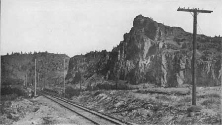
The valley on the right (east) is wide and the hills are low as far as Clarkston siding, but on the opposite side of the river and rudely parallel with it there is a mountainous ridge, formed by the overturned northwest side of a syncline which lies parallel with the general course of the road and which is shown in figure 25. The southeast side this fold is obscured by the lake beds, which cover all older formations as with a mantle, but in the vicinity of Clarkston the Madison limestone is exposed, dipping to the northwest. At milepost 181 begins a long hillside cut in the upper part of this limestone, but as the beds trend in nearly the same direction as the track not much of the formation can be seen. The cut continues to milepost 183, where the valley opens out. On the right the hard formations are covered by clay deposited in the old lake, but on the left the Madison limestone swings across the river and makes a bluff more than 100 feet high above the St. Paul road. Before reaching Lombard the river makes a sharp bend to the left (north) and enters a box canyon1 in the Madison limestone. (See Pl. XVIII.) The height of the walls of this canyon is about 300 feet, but it decreases downstream, owing to the fact that rocks dip in that direction.
1The term box canyon is applied in many parts of the West to a narrow canyon having vertical or nearly vertical walls.
|
| PLATE XVIII.—CLIFFS OF MADISON LIMESTONE AT LOMBARD, MONT. View from the crags a short distance up Sixteenmile Creek. Photograph by Curtis & Miller, Seattle, Wash. |
|
Lombard. Elevation 3,977 feet. Population 155.* St. Paul 1,077 miles. |
At Lombard the St. Paul line crosses the Northern Pacific and turns to the east up Sixteen Mile Creek, crossing the divide to the head of Musselshell River. Beyond Lombard the thick beds of the Madison limestone descend rapidly and pass below water level about a mile from the station. The Quadrant formation does likewise, and at milepost 186 attempts have been made to open a mine on a coal bed either in this formation or in the overlying Kootenai formation, but the coal is badly crushed and dirty and the project has been abandoned.
A short distance beyond the coal mine there is a fault that brings the coal-bearing rocks into contact with the Belt series, which consists of red and green shale and argillite, very much broken and disturbed. (See fig. 27.) The Belt rocks form the surface along the river for about 3 miles, including the large bend which the river makes to the left. At milepost 189 the railway crosses this fault again and an igneous mass that was intruded along the fault. The road then enters the Quadrant formation, the lower part of which is generally characterized by very brilliant red limestone and clay. This color is well shown on the right as the train rounds a sharp bend of the river and it is visible up the hill slope beyond milepost 190, where the train crosses a spring that wells up in large volume from the limestone. The spring forms a beautiful pool, and the stream that flows from it is carried in ditches for a long distance and used to irrigate the bottom land farther down the river.
|
| FIGURE 27.—Fold and fault in the rocks near Lombard, Mont. |
About 1,000 feet beyond milepost 191 the fault is crossed for the last time, and here the conditions are much like those that prevail at the other crossings. The rocks south of the fault carry a coal bed similar to the one opened near Lombard, and the formation is in contact with a large mass of igneous rock which on the other side rests against the rocks of the Belt series. The Belt rocks are considerably altered, apparently by the heat of the intruded mass, and some mineralization of the rocks has been the result, but although many prospect pits can be seen on the hillsides, little of value has been found.
|
Toston. Elevation 3,925 feet. Population 384.* St. Paul 1,086 miles. |
The hard rocks that form the high hills soon give way to the soft clay of the lake beds, and at Toston the valley opens out on both sides nearly as far as the eye can reach. The river has no well-marked channel, and its surface is only a few feet below the general level of the plain. This is the result of the washing in of fine silty material, in which the valley has been cut. The valley was originally formed by some downward movement in the crust of the earth (see p. 112) and then it was occupied by a lake, probably an extension of the body of water that occupied Gallatin Valley in Miocene time. After the lake basin was filled or drained the land was raised, and Missouri River has carved its present valley almost entirely in the soft materials laid down in the old lake. Owing to the softness of this material it is washed into the river at every shower and so the stream is supplied with more sediment than it can carry. This material therefore settles to the bottom, and the channel of the stream is kept at nearly the same level as the bottom land on either side.
Opposite milepost 201 the hills on the left closely approach the river bank and for a height of 400 feet they appear to be composed entirely of clay deposited in the old lake.
| <<< Previous | <<< Contents >>> | Next >>> |
bul/611/sec17.htm
Last Updated: 28-Mar-2006